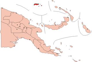
Location of Wuvulu Island at top left (as "Wululu")
Wuvulu Island (also known as Mary Island, Matty, Maty Island, Tiger Island, Tiger-Inseln and Wuwulu) is part of the Western Islands of the Bismarck Archipelago in the western Pacific Ocean, part of Manus Province, Papua New Guinea. It is the westernmost island of the thirteen island groups that make up island chain in the archipelago.[1] It is an island of volcanic origin encircled by a coral reef with a maximum height of three meters (10 feet) above sea level.[2]
The first sighting by Europeans of Wuvulu Island was by the Spanish navigator Iñigo Órtiz de Retes on 27 July 1545 when on board of the carrackSan Juan tried to return from Tidore to New Spain. He charted this island together with the nearby islands, Aua and Manu, as La Barbada (the bearded island in Spanish).[3][4]
Wuvulu Island was part of German New Guinea until the First World War. During German times, the island was purchased by the German Administration, which excluded from the purchase three areas for ‘native reserves’. Two of these reserves were at the western end of the Island and the third was at the eastern end. The latter area was known as Ruvuraue (230 hectares, 568 acres).
In 1907 the German Administration transferred the property known as Agita (800 hectares, 2170 acres) to Rudolph Wahlen – the property was all of the island with the exception of the three reserves. The German Administration, however, also gave a restricted occupancy to Wahlen over Ruvuraue Reserve.
In 1912 the area known as Ruvuraue appears to have been transferred to Rudolph Wahlen. This was apparently in return for the granting to the local people of certain rights to taro pits on the properties. The reserve aspect of this land would have been extinguished by this action. Both titles were made the subject of encumbrances relating to mining and to transfer back to the Administration for landing places and other public purposes.
After the First World War the title vested in the custodian of expropriated property. In 1928 a draft certificate of title was issued in respect of both parties.
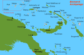
New Britain is the largest island in the Bismarck Archipelago, part of the Islands Region of Papua New Guinea. It is separated from New Guinea by a northwest corner of the Solomon Sea and from New Ireland by St. George's Channel. The main towns of New Britain are Rabaul/Kokopo and Kimbe. The island is roughly the size of Taiwan. When the island was part of German New Guinea, its name was Neupommern . In common with most of the Bismarcks it was largely formed by volcanic processes, and has active volcanoes including Ulawun, Langila, the Garbuna Group, the Sulu Range, and the volcanoes Tavurvur and Vulcan of the Rabaul caldera. A major eruption of Tavurvur in 1994 destroyed the East New Britain provincial capital of Rabaul. Most of the town still lies under metres of ash, and the capital has been moved to nearby Kokopo.
The Admiralty Islands are an archipelago group of 18 islands in the Bismarck Archipelago, to the north of New Guinea in the South Pacific Ocean. These are also sometimes called the Manus Islands, after the largest island.
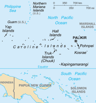
The Caroline Islands are a widely scattered archipelago of tiny islands in the western Pacific Ocean, to the north of New Guinea. Politically, they are divided between the Federated States of Micronesia (FSM) in the central and eastern parts of the group, and Palau at the extreme western end. Historically, this area was also called Nuevas Filipinas or New Philippines, because they were part of the Spanish East Indies and were governed from Manila in the Philippines.
The Bismarck Archipelago is a group of islands off the northeastern coast of New Guinea in the western Pacific Ocean and is part of the Islands Region of Papua New Guinea. Its area is about 50,000 square km.
The Biak Islands are an island group of Papua province, eastern Indonesia in the Cenderawasih Bay 50 km off the north-western coast of the island of New Guinea. The group consists of the main islands of Biak, Supiori and Numfor, and numerous smaller islands, mostly covered in rain forest. The population of the archipelago is about 130,000.
AUA may stand for:
The Bismarck Sea lies in the southwestern Pacific Ocean within the nation of Papua New Guinea. It is located northeast of the island of New Guinea and south of the Bismarck Archipelago. It has coastlines in districts of the Islands Region, Momase Region, and Papua Region.
The Admiralty Islands languages are a group of some thirty Oceanic languages spoken on the Admiralty Islands. They may include Yapese, which has proven difficult to classify.
Manus Province is the smallest province in Papua New Guinea in terms of both land area and population, with a land area of 2,100 square kilometres (810 sq mi), but with more than 220,000 square kilometres (85,000 sq mi) of water, and the total population is 60,485. The provincial town of Manus is Lorengau.
The Wuvulu-Aua language is an Austronesian language which is spoken on the Wuvulu and Aua Islands and in the Manus Province of Papua New Guinea.
The Western Islands are a group of islands in the Bismarck Archipelago, and within Manus Province of the Islands Region, in northern Papua New Guinea.
Aua is an island in the Bismarck Archipelago. It is part of the Western Islands within Manus Province of northern Papua New Guinea.
New Guinea is the world's second-largest island, with an area of 785,753 km2 (303,381 sq mi). Located in Melanesia in the southwestern Pacific Ocean, the island is separated from Australia by the 150-kilometre wide Torres Strait, though both landmasses lie on the same continental shelf, and were united during episodes of low sea level in the Pleistocene glaciations as the combined landmass of Sahul. Numerous smaller islands are located to the west and east. The island's name was given by Spanish explorer Yñigo Ortiz de Retez during his maritime expedition of 1545 due to the resemblance of the indigenous peoples of the island to those in the African region of Guinea.
The Solomon Islands (archipelago) is an island group in the western South Pacific Ocean, north-east of Australia. The archipelago is in the Melanesian subregion and bioregion of Oceania and forms the eastern boundary of the Solomon Sea. The many islands of the archipelago are distributed across the sovereign states of Papua New Guinea and Solomon Islands. The largest island in the archipelago is Bougainville Island, which is a part of the Autonomous Region of Bougainville along with Buka Island, the Nukumanu Islands, and a number of smaller nearby islands. Much of the remainder falls within the territory of Solomon Islands and include the atolls of Ontong Java, Sikaiana, the raised coral atolls of Bellona and Rennell, and the volcanic islands of Choiseul, Guadalcanal, Makira, Malaita, New Georgia, the Nggelas, Santa Isabel, and the Shortlands. The Santa Cruz Islands are not a part of the archipelago.
The Seimat language is one of three Western Admiralty Islands languages, the other two being Wuvulu-Aua and the extinct Kaniet. The language is spoken by approximately 1000 people on the Ninigo and the Anchorite Islands in western Manus Province of Papua New Guinea. It has subject–verb–object (SVO) word order.
The Ninigo Islands are a group of 31 islands within the Western Islands of the Bismarck Archipelago, Papua New Guinea. Their coordinates are 1°16′S144°15′E.
The Hermit Islands are a group of 17 islands within the Western Islands of the Bismarck Archipelago, Papua New Guinea. Their coordinates are 1°30′S145°4′E.
The Kaniet Islands are the easternmost group islands within the Western Islands of the Bismarck Archipelago, Papua New Guinea. It consists four islands and one islet. Their coordinates are 0°54′S145°32′E, located north-east of the Hermit Islands. Sae Island is a nearby island often subsumed under the Kaniet(-Sae) Islands, albeit the two are distinct. Another name for the Kaniet(-Sae) Islands is "Anchorite Islands".
Sae Island is the northernmost island within the Western Islands of the Bismarck Archipelago, Papua New Guinea. It is located just north-west of the Kaniet Islands, under which it is often subsumed, although the two are distinct. Another name for the Kaniet(-Sae) Islands is "Anchorite Islands".
This page is based on this Wikipedia article Text is available under the CC BY-SA 4.0 license; additional terms may apply. Images, videos and audio are available under their respective licenses.