Unionville, North Carolina

Last updated

Unionville, North Carolina
Seal of Unionville, North Carolina.jpg
NCMap-doton-Unionville.PNG
Location of Unionville, North Carolina
Coordinates: 35°04′18″N80°31′02″W / 35.07167°N 80.51722°W / 35.07167; -80.51722
Country United States
State North Carolina
County Union
Incorporated1911, 1998 [1]
Government
  MayorRandy Baucom
Area
[2]
  Total29.40 sq mi (76.16 km2)
  Land29.22 sq mi (75.67 km2)
  Water0.19 sq mi (0.49 km2)
Elevation
[3]
584 ft (178 m)
Population
 (2020)
  Total6,643
  Density227.37/sq mi (87.79/km2)
Time zone UTC-5 (Eastern (EST))
  Summer (DST) UTC-4 (EDT)
FIPS code 37-69260 [4]
GNIS feature ID2406780 [3]
Website http://unionvillenc.com/

Unionville is a rural town in Union County, North Carolina, United States. The population was 6,643 at the 2020 census.

Contents

Geography

According to the United States Census Bureau, the town has a total area of 26.2 square miles (68 km2), of which 26.2 square miles (68 km2) is land and 0.04 square miles (0.10 km2) (0.11%) is water. It is situated in the foothills of the Uwharrie Mountains.

Demographics

Historical population
CensusPop.Note
1920 135
1930 1403.7%
1940 1442.9%
1950 124−13.9%
1960 119−4.0%
2000 4,797
2010 5,92923.6%
2020 6,64312.0%
U.S. Decennial Census [5]

2020 census

Unionville racial composition [6]
RaceNumberPercentage
White (non-Hispanic)5,92389.16%
Black or African American (non-Hispanic)1372.06%
Native American 120.18%
Asian 560.84%
Pacific Islander 80.12%
Other/Mixed 2033.06%
Hispanic or Latino 3044.58%

As of the 2020 United States census, there were 6,643 people, 2,614 households, and 2,094 families residing in the town.

2000 census

At the 2000 census, there were 4,797 people in 1,670 households, including 1,382 families, in the town. The population density was 183.1 inhabitants per square mile (70.7/km2). There were 1,717 housing units at an average density of 65.5 per square mile (25.3/km2). The racial makeup of the town was 96.48% White, 2.23% African American, 0.19% Native American, 0.33% Asian, 0.48% from other races, and 0.29% from two or more races. Hispanic or Latino of any race were 1.71%. [4]

Of the 1,670 households, 44.3% had children under the age of 18 living with them, 72.4% were married couples living together, 6.8% had a female householder with no husband present, and 17.2% were non-families. A total of 14.4% of households were one person and 5.3% were one person aged 65 or older. The average household size was 2.85 and the average family size was 3.15.

The age distribution was 29.0% under the age of 18, 6.6% from 18 to 24, 34.8% from 25 to 44, 20.9% from 45 to 64, and 8.8% 65 or older. The median age was 35 years. For every 100 females, there were 97.3 males. For every 100 females age 18 and over, there were 96.2 males.

The median household income was $57,478 and the median family income was $62,736. Males had a median income of $40,145 versus $28,889 for females. The per capita income for the town was $20,266. About 3.0% of families and 5.3% of the population were below the poverty line, including 5.6% of those under age 18 and 15.6% of those age 65 or over.

Education

The Unionville community has a rich educational history dating to the nineteenth century with the founding of the Union Institute in 1886. Currently, Unionville houses Piedmont High School, Piedmont Middle School, Unionville Elementary School, Porter Ridge Elementary School, Porter Ridge Middle School, Porter Ridge High School.

History

The town of Unionville was originally chartered by the North Carolina General Assembly in 1911. Town officials met in the Union Institute building until the building was destroyed by fire. Local leaders, working with the general assembly succeeded in reactivating the town's charter in 1998.

Union County was formed in 1842 from parts of Anson County and Mecklenburg County. The town of Unionville was created in the Goose Creek community on the former Mecklenburg / Anson county line which ran north to south along what is now Unionville Road.

Union Institute

Founded in 1886 by Professor Oliver C. Hamilton, the Union Institute was organized to serve the educational needs of the community. In 1885, local residents provided materials and labor for the construction of the school which served students of all ages from Union County as well as upstate South Carolina. Professor Hamilton left the school in 1898, but returned to the institute serving as head instructor in 1904. Originally constructed as a private school, the Union Institute was turned over to the county board of education in 1910. The two story structure was constructed next to the site of the current Unionville Community Center. In January 1917, a fire destroyed the building in its entirety. Students escaping from the building saved the school bell from the second story porch. The original Union Institute bell has served each successive Unionville School since; and today is displayed from the main entrance to Unionville Elementary School.

Town Hall

Unionville Town Hall is located at the intersection of Unionville Road and Unionville-Indian Trail Rd. Town Hall was originally constructed as the fellowship for the Unionville Presbyterian Church which was constructed in 1915. The sanctuary of the Unionville Presbyterian Church was destroyed by fire in July,1994. After meeting for the next five years in the former fellowship hall, the congregation of Unionville Presbyterian Church dedicated the building and grounds to the town of Unionville for municipal use. The first town meeting held in the current town hall occurred on February 17, 2000.

Government

The Town of Unionville operates under the Mayor-Council form of government as provided by part 3 of Article 7 of Chapter 160A of North Carolina general statutes. Established in 1911, the original town charter provided for a Mayor, five Commissioners as well as a secretary, treasurer, and town Constable. In 1911, the town's first Mayor was J.B. Little. Commissioners were C.D. Benton, T.L.A. Helms, J.T. Price, A.A. Secrest and Dr. A.D.N. Whitley.

After a fire destroyed many town records in 1917, town officials ceased meeting; resulting in a loss of the town's charter.

In 1998, a majority of voters cast votes to revive the charter of the town.

Currently, the Mayor and Commissioners are elected to serve four year terms.

Public Safety

Law enforcement in the town of Unionville is provided by the Union County Sheriff's Office as well as the North Carolina State Highway Patrol.

Fire protection is provided by the Town of Unionville Volunteer Fire Department, an ISO class 3 rated fire department. The Unionville Fire Department is a combination paid / volunteer department which operates out of two stations; Station 21 (located at 4919 Unionville Road, Monroe, NC 28110) and Station 22 (located at 3229 Concord HWY, Monroe, NC 28110).

Advanced Life Support level Emergency Medical Services (EMS) in the town is provided by Union Emergency Medical Services, and augmented by first responder / EMT support from the Unionville Fire Department.

Community Involvement

Unionville is widely known for its community spirit. For over 70 years, the annual Unionville Barbeque, held at Unionville Elementary school, has served as one of the largest fundraisers for a school in the state of North Carolina. Other community events held annually include an annual July 4 parade, Christmas parade and tree lighting ceremony, and community concerts (Concerts in the Park) held on the grounds of the community center.

Unionville Lion's Club

Since becoming chartered in December 1970, the Unionville Lion's club has remained active in the community as well as town events.

Sam F. Keziah American Legion post.

Unionville is served by the Sam F. Keziah American Legion Post; Post 535.

Related Research Articles

<span class="mw-page-title-main">Yancey County, North Carolina</span> County in North Carolina, United States

Yancey County is a county located in the U.S. state of North Carolina. As of the 2020 census, the population was 18,470. Its county seat is Burnsville.

<span class="mw-page-title-main">Union County, North Carolina</span> County in North Carolina, United States

Union County is a county located in the U.S. state of North Carolina. As of the 2020 census, the population was 238,267. Its county seat is Monroe. Union County is included in the Charlotte-Concord-Gastonia, NC-SC Metropolitan Statistical Area.

<span class="mw-page-title-main">Towns County, Georgia</span> County in Georgia, United States

Towns County is a county located in the northeastern part of the U.S. state of Georgia. As of the 2020 census, the population was 12,493. Its county seat is Hiawassee. The county was created on March 6, 1856, and named for lawyer, legislator, and politician George W. Towns.

<span class="mw-page-title-main">Zionsville, Indiana</span> Town in Indiana, United States

Zionsville is a suburban town located in the extreme southeast area of Boone County, Indiana, United States, northwest of Indianapolis. The population was 14,160 at the 2010 census, 30,693 at the 2020 census.

<span class="mw-page-title-main">Leland, North Carolina</span> Town in North Carolina, United States

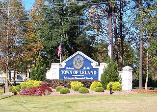
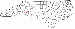
Leland is the most populous town in Brunswick County, North Carolina, United States. The population was 23,504 at the 2020 census, up from 13,527 in 2010. As of 2020, it is considered to be one of the fastest growing towns in North Carolina. It is part of the Wilmington, NC Metropolitan Statistical Area. and the Cape Fear Council of Governments. The town of Leland is in the northeastern part of Brunswick County, with the town of Navassa to the north, Belville to east, and Boiling Spring Lakes to the south. It is part of the Town Creek township, and Cape Fear region of North Carolina, a short distance north of the South Carolina state line. Leland is located five miles (8.0 km) west of Wilmington, 71 miles (114 km) north of Myrtle Beach, 84 miles (135 km) southeast of Fayetteville, and 135 miles (217 km) southeast of Raleigh.

<span class="mw-page-title-main">Woodfin, North Carolina</span> Town in North Carolina, United States

Woodfin is a town in Buncombe County, North Carolina, United States. The population was 6,123 as of the 2010 census. It is part of the Asheville Metropolitan Statistical Area. The town is named for Nicholas Washington Woodfin, a renowned lawyer and statesman of early North Carolina, under whom Governor Zebulon Vance clerked as an attorney. Woodfin is the only municipality bearing the name Woodfin in the United States. The town was incorporated in 1971, although the community itself dates back to at least the mid-19th century.

<span class="mw-page-title-main">High Shoals, North Carolina</span> City in North Carolina, United States

High Shoals is a city in Gaston County, North Carolina, United States, named for the high rocky shoal across the Catawba River. The population was 696 at the 2010 census.

<span class="mw-page-title-main">Stanley, North Carolina</span> Town in North Carolina, United States

Stanley is a town in Gaston County, North Carolina, United States. The population was 3,556 at the 2010 census.

<span class="mw-page-title-main">Summerfield, North Carolina</span> Town in North Carolina, United States

Summerfield is a town in Guilford County, North Carolina. As of the 2020 census, the population was 10,951.

<span class="mw-page-title-main">Harmony, North Carolina</span> Town in North Carolina, United States

Harmony is a town in Iredell County, North Carolina, United States. The town was incorporated in 1927 and is located in northeastern Iredell County and lies in the eastern portion of the North Carolina High Country. It is primarily located in Turnersburg Township, with its northernmost portion in Eagle Mills Township. The population was 531 at the 2010 census.

<span class="mw-page-title-main">Mint Hill, North Carolina</span> Town in North Carolina, United States

Mint Hill is a suburban town in southeastern Mecklenburg and northwestern Union counties in the U.S. state of North Carolina, it is a major suburb on the outskirts of Charlotte and near the Cabarrus County line. The population was 22,722 at the 2010 census.

<span class="mw-page-title-main">Carolina Beach, North Carolina</span> Town in North Carolina, United States

Carolina Beach is a beach town in New Hanover County, North Carolina, United States, situated about 12 miles (19 km) south of Wilmington International Airport in southeastern coastal North Carolina. As of the 2020 census, the city population was 6,564. It is part of the Wilmington metropolitan area. The community of Wilmington Beach was annexed by the town in 2000.

<span class="mw-page-title-main">Kure Beach, North Carolina</span> Town in North Carolina, United States

Kure Beach is a town in New Hanover County, North Carolina, United States, approximately 15 miles south of Wilmington. It is part of the Wilmington Metropolitan Statistical Area. The population was 2,012 at the 2010 census. It is found on Pleasure Island directly south of the Wilmington Beach annex of Carolina Beach and just north of Fort Fisher. The town is less than 1 square mile (2.6 km2) in area, stretching along about 3.5 miles (5.6 km) of coastline along Pleasure Island, and a maximum width of less than 0.5 miles (0.80 km), in most places only a few hundred yard/meters wide.

<span class="mw-page-title-main">Gaston, North Carolina</span> Town in North Carolina, United States

Gaston is a town in Northampton County, North Carolina, United States. The population was 1,152 at the 2010 census. It is part of the Roanoke Rapids, North Carolina Micropolitan Statistical Area.

<span class="mw-page-title-main">Wentworth, North Carolina</span> Town in Rockingham County

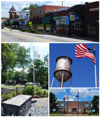
Wentworth is a town in Rockingham County, North Carolina, United States. The population was 2,646 at the 2020 census. Wentworth is the county seat of Rockingham County and is part of the Greensboro-High Point metropolitan area of the Piedmont Triad. On May 6, 2022, an EF-1 Tornado hit Wentworth. The storm traveled as a supercell with crazy structure from the Pilot Mountain, North Carolina, and Pinnacle, North Carolina, area across central Stokes County and into Rockingham County. It took out trees, damaged homes, and blocked roads before it lifted off southwest of Reidsville.

<span class="mw-page-title-main">Waxhaw, North Carolina</span> Town in North Carolina, United States

Waxhaw is a town in Union County, North Carolina, United States. The population was 20,534 according to the 2020 Census. The population grew 108.28% from 2010. The name is derived from the indigenous people who lived in the area, who were known as the Waxhaw people.

<span class="mw-page-title-main">Birmingham Township, Chester County, Pennsylvania</span> Township in Pennsylvania, United States

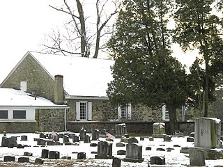
Birmingham Township is a township in Chester County, Pennsylvania, United States. The population was 4,085 at the 2020 census.

<span class="mw-page-title-main">Williamston, South Carolina</span> Town in South Carolina, United States

Williamston is a town in Anderson County, South Carolina. The population was 4,043 at the 2020 census.

<span class="mw-page-title-main">Friendsville, Tennessee</span> City in Tennessee, United States

Friendsville is a city in Blount County, Tennessee. Its population was 896 at the 2020 census. It is included in the Knoxville, Tennessee Metropolitan Statistical Area.

<span class="mw-page-title-main">Addison, Vermont</span> Town in Vermont, United States

Addison is a town in Addison County, Vermont, United States. It was founded October 14, 1761. The population was 1,365 at the 2020 census.

References

  1. "North Carolina Gazetteer" . Retrieved November 25, 2023.
  2. "ArcGIS REST Services Directory". United States Census Bureau. Retrieved September 20, 2022.
  3. 1 2 U.S. Geological Survey Geographic Names Information System: Unionville, North Carolina
  4. 1 2 "U.S. Census website". United States Census Bureau . Retrieved January 31, 2008.
  5. "Census of Population and Housing". Census.gov. Retrieved June 4, 2015.
  6. "Explore Census Data". data.census.gov. Retrieved December 21, 2021.