The Lionshead district of VailLost Lake north of Vail
Vail was incorporated in 1966, four years after the opening of Vail Ski Resort. The ski area was founded by Pete Seibert and local rancher Earl Eaton in 1962, at the base of Vail Pass. The pass was named after Charles Vail, the highway engineer who routed U.S. Highway 6 through the Eagle Valley in 1940, which eventually became Interstate 70. Seibert, a New England native, served in the U.S. Army's 10th Mountain Division during World War II, which trained at Camp Hale, 14 miles south of Vail between Red Cliff and Leadville. He was wounded in Italy at the Battle of Riva Ridge but went on to become a professional skier after he recovered.[13]
Seibert, with other former members of the 10th Mountain Division, returned to Colorado after World War II with the intention of opening a ski resort. During training for ski troopers at Camp Hale, he bivouacked on Vail Mountain and identified it as an ideal ski mountain. In the early 1960s, Seibert got funds from a group of Colorado investors, including Jack Tweedy, and with Earl Eaton bought a ranch at the base of the mountain and eventually incorporated as Vail Associates. As plans continued for a new ski resort, Seibert hired Morrie Shepard as Vail's first ski school director. Shortly after, Shepard recruited Rod Slifer from Aspen to be the assistant ski school director. Slifer also became the only real estate broker in the early years of Vail and would later be the broker in the transaction that allowed Vail to buy a ranch, now known as the world-famous Beaver Creek.
In December 1962, Vail officially opened for its first season. It operated a gondola lift and two ski lifts on the mountain owned by the United States Forest Service. The village was established at the base of the mountain for local residents and offered lodging for visitors. It quickly grew throughout the valley, with housing added first in East Vail and then West Vail, and additional lodging added in Lionshead in the late 1960s.[13][14]
Within the first year, the village had a ski shop operated by Dick Hauserman and Joe Langmaid, a ski boutique operated by Blanche Hauserman and Bunny Langmaid, a hotel and restaurant operated by Pepi Gramshammer, and the mountain had a manager.[15] By 1969, Vail was the most popular ski resort in the state. In 1988 Vail opened China Bowl, making Vail the third largest ski area in North America.
In 2023, the village paid $17 million to Vail Resorts to prevent Vail Resorts from building housing for 165 workers. This was preceded by a lengthy conflict where the village sought to block the construction of housing.[16]
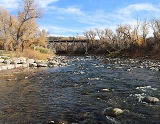
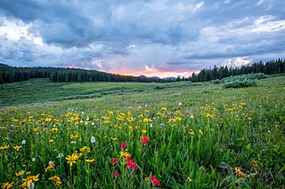
Vail's average elevation is 8,150 feet (2,480m)above sea level. The town has a total area of 4.5 square miles (12km2), with no lakes (there is, however, at least one pond). Gore Creek flows from east to west through the center of town.
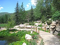
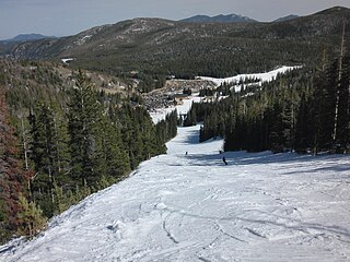
Vail Mountain rises from 8,120 feet (2,470m) to 11,570 feet (3,530m), giving a vertical rise of 3,450 feet (1,050m).[17] It has a 5,289 acres (2,140ha) skiable area, 33 ski lifts, 193 marked skiing trails on three faces: the front side, the back bowls, and Blue Sky Basin. The seven back bowls are Sun Down Bowl, Sun Up Bowl, Teacup Bowl, China Bowl, Siberia Bowl, Inner Mongolia Bowl, and Outer Mongolia Bowl. Blue Sky Basin includes Pete's Bowl and Earl's Bowl—to commemorate Pete Seibert and Earl Eaton. The mountain resort also includes 17 miles of recreation paths, botanical gardens, and an outdoor amphitheater.[18]
Climate
Vail has warm summers and cold winters because of its elevation. Depending on the classification used, it is either an alpine or subarctic climate transitional with humid continental due to the mild daytime temperatures in September bringing the daily mean to around 50°F (10°C). Minimum temperatures mostly remain below the freezing point from late September to late May. The town receives an average of 200 inches (5.1m) of snowfall per season, with even more in the surrounding mountains. Roads may close occasionally during heavy snowfall. Summer temperatures can reach the 80s, but are more often in the mid to high 70s. Combined with mountain breezes, this makes summers refreshing and cool. For being a borderline subarctic climate daytime temperatures are very mild, indicating high diurnal temperature variation due to the altitude.
Climate data for Vail, Colorado, 1991–2020 normals, extremes 1985–present
The 2020 census[22] found 4,835 people living in the 2,268 households in the town. There were 7,300 housing units, with 67.3% of them being unoccupied. The racial makeup of the town was 86.33% White, 0.83% African American, 0.41% Native American, 1.80% Asian, 0.00% Pacific Islander, 3.02% from other races, and 7.60% from two or more races. Hispanic or Latino people of any race were 10.34% of the population.
Of the 2,268 households, 46.4% were married couples, 18.4% had a female householder with no spouse present, and 26.6% had a male householder with no spouse present. The average family size was 2.62 people.
The population age distribution was 7.8% people under the age of 20, 31.7% from 20 to 39, 28.7% from 40 to 59, 29.7% from 60 to 79, and 3.6% who were 80 years of age or older. The median age was 50.2 years.
The median household income was $100,417, and the median family income was $127,336. 6.0% of the population were in poverty. The average rent was $1,514, and the homeownership rate was 75%.
7% of the population had a high school or equivalent education, 19.2% had some college but no degree, 6.5% had an associate's degree, 41.5% had a bachelor's degree, and 25.1% had a graduate or professional degree.
Economy
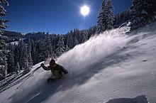
The Vail economy relies heavily on tourism. The main attraction in Vail is winter sports such as skiing and snowboarding on the mountain, in addition to snowmobiling and snowshoeing, among many other winter sports. Vail is also a summer resort and golfing center. Summer activities include guided hikes, mountain biking, horseback riding, carriage rides and fishing. Vail is also developing as a cultural center, with various art and music venues active throughout the summer. The town has a developed culinary center, with a variety of restaurants.
A Vail Resorts spokesperson said in 2022 that there is a deficit of some 6,000 beds for the county's work force.[23]
Charles "Ted" Kindel was the first mayor of Vail, elected when it became a town on August 3, 1966.[24]
Vail has a council-manager form of government and is led by a seven-member town council elected at-large. The current mayor is Kim Langmaid, whose seat will be vacated following the 2023 town council election due to term limits.[3]
Flag
The flag of Vail is flown by government buildings and businesses in Vail. It is composed of three stripes which are light blue, white, and dark green, which represent the blue Colorado sky, white powder snow, and the surrounding Evergreen forest, respectively. Centered on the flag is the original Vail element, which consists of two "V"s, the upper to represent the surrounding mountains, while the lower represents the Vail Valley. A gold wreath surrounds the element to represent excellence and achievement.[25]
Education
Vail's public schools are part of Eagle County School District RE-50, with high school students attending the nearby Battle Mountain High School in Edwards. Eagle County Schools also offers the Vail Ski & Snowboard Academy, a joint program with area ski programs for students in grades 5–12 who are involved in competitive skiing and snowboarding. Private schools in the Vail area include Vail Mountain School (K-12), Vail Christian High School (9–12), St. Clare of Assisi Catholic School (K-8), and the Vail Academy (PK-8). Higher education is available at the Vail Eagle Valley campus of Colorado Mountain College.
A broadcast translator for public radio station KUNC allows listeners in the Eagle Valley to listen at 99.7 FM.
Two specialty television networks have stations in Vail, Plum TV and Resort Sports Network. The latter, branded as TV-8, also broadcasts on the low-powered UHF station K34QB-D. The Ski Channel is available only on DirecTV on Channel 1860.
During the mid-1970s, Vail became known as the Western White House of PresidentGerald Ford, when he conducted much of the nation's business from The Lodge at Vail hotel. The national media followed Ford to Vail and often broadcast television pictures of Vail's mountain slopes.[26]
Vail is served by Eagle County Airport near Gypsum, 30 miles (48km) to the west. Native Americans used to call the area near the airport the "hole in the sky" because storms seemed to avoid it. Vail is modeled on European ski towns, many of which are car-free, and the town is partially pedestrianized. The town operates the largest free shuttle bus system in the United States and has ten hybrid-electric buses. At each bus stop, a sign reports when the next two buses will arrive.
The In-Town Shuttle provides service every five minutes during peak winter times, and every 15 minutes off-peak, between Golden Peak, Vail Village, the business district, and Lionshead, with live schedule information provided at bus stops by Global Positioning System technology, which tracks buses. Other routes centering on the Transportation Center service the East and West Vail districts on a scheduled, but less frequent basis.[27]
The Colorado Department of Transportation, through its Bustang program, provides intercity transportation to Vail along its West Line. The West Line goes from Denver to Grand Junction and back.[28]
Highways
Interstate 70 runs east–west through the middle of Vail and is the only road to or from Vail, with exits at East Vail, at the base of Vail Pass, the town of Vail, and West Vail. From the east, the highway comes from Denver, 97 miles (156km) away, passes through Eisenhower Tunnel and over the Continental Divide, by-passing Loveland Pass, and over Vail Pass, dropping down into Vail Valley. To the west, it meets U.S. Highway 24 at Dowd Junction, passes through Avon, Edwards, Colorado, and Eagle, through Glenwood Canyon traveling and on to Grand Junction, and reaches Utah, where it ends at the intersection with Interstate 15.
In West Vail, U.S. Route 6 (which still exists as a service road between East Vail, Vail, and West Vail) merges with I-70 at Dowd Junction. I-70 roughly follows the original Highway 6 route until the two highways diverge again in Silverthorne, 31 miles (50km) to the east.
Vail is mentioned in episode 9 of season 1 in the TV show Friends, as the place Rachel Green could not afford a ticket to go ski with her family.[29]
Vail, Colorado is referenced in the Stephen Adly-Guirgis play Den of Thieves as the place Paul would like to go to for a "Holistic wellness retreat".[30]
Telluride is the county seat and most populous town of San Miguel County in the southwestern portion of the U.S. state of Colorado. The town is a former silver mining camp on the San Miguel River in the western San Juan Mountains. The first gold mining claim was made in the mountains above Telluride in 1875, and early settlement of what is now Telluride followed. The town was founded in 1878 as "Columbia", but due to confusion with a California town of the same name, was renamed Telluride in 1887 for the gold telluride minerals found in other parts of Colorado. These telluride minerals were never found near Telluride, but the area's mines for some years provided zinc, lead, copper, silver, and other gold ores.
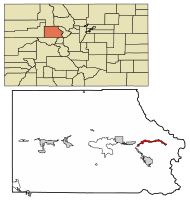
Eagle County is a county located in the U.S. state of Colorado. As of the 2020 census, the population was 55,731. The county seat is the Town of Eagle and the most populous community is Edwards. The county is named for the Eagle River.
Eagle is the Statutory Town that is the county seat of Eagle County, Colorado, United States. The town population was 7,511 at the 2020 United States Census, a +15.41% increase since the 2010 United States Census. Eagle is the part of the Edwards, CO Micropolitan Statistical Area.
Minturn is a home rule municipality in Eagle County, Colorado, United States. The town population was 1,033 at the 2020 United States Census.
Vail Resorts, Inc. is an American mountain resort company headquartered in Broomfield, Colorado. The company is divided into three divisions. The mountain segment owns and operates 40 mountain resorts in four countries, Vail Resorts Hospitality owns or manages hotels, lodging, condominiums and golf courses, and the Vail Resorts Development Company oversees property development and real estate holdings.
Keystone Resort is a ski resort located in Keystone, Colorado, United States. Since 1997, the resort has been owned and operated by Vail Resorts. It consists of three mountains – Dercum Mountain, North Peak, and the Outback – and five Bowls offering skiing at all levels. The three mountains are connected by a series of ski lifts and gondolas with access from two base areas.
Aspen Mountain is a ski area in the western United States, located in Pitkin County, Colorado, just outside and above the city of Aspen. Situated on the north flank of Aspen Mountain, its summit elevation is 11,212 feet (3,417 m) above sea level. Aspen Mountain forms the end of Richmond Ridge, a long ridge that extends ten miles (16 km) south at approximately 11,000 ft (3,350 m) to join the main spine of the Elk Mountains.
Shrine Pass, elevation 11,094 ft (3,381 m), is a mountain pass in the Sawatch Range of central Colorado.
Beaver Creek Resort is a major ski resort in the western United States, near Avon, Colorado. The resort comprises three villages, the main Beaver Creek Village, Bachelor Gulch, and Arrowhead to the west. The resort is owned and operated by Vail Resorts which operates multiple additional resorts. Beaver Creek is a regular host of World Cup events, usually in early December.
Beaver Creek is an unincorporated community in Eagle County, Colorado, United States. Beaver Creek is located immediately south of the town of Avon and encompasses the Beaver Creek Resort and adjacent business, lodging, golf course, and residential areas. The U.S. Post Office at Avon serves Beaver Creek postal addresses.
Park City Mountain Resort (PCMR) is a ski resort in the western United States in Park City, Utah, located 32 miles (51 km) east of Salt Lake City. Park City, as the ski resort and area is known, contains several training courses for the U.S. Ski Team, including slalom and giant slalom runs. During the 2002 Winter Olympics, it hosted the snowboarding events and the men's and women's alpine giant slalom events.
Breckenridge Ski Resort is an alpine ski resort in the western United States, in Breckenridge, Colorado. Recognized for acres of skiable terrain across five mountain peaks, it welcomes thousands of skiers and snowboarders each season. Just west of the Continental Divide in Summit County, it is perennially one of the most visited ski resorts in the western hemisphere. Breckenridge is owned and operated by Vail Resorts, Inc.
Vail Ski Resort is a ski resort in the western United States, located near the town of Vail in Eagle County, Colorado. At 5,289 acres, it is the third-largest single-mountain ski resort in the U.S., behind Big Sky and Park City, featuring seven bowls and intermediate gladed terrain in Blue Sky Basin.
Eldora Mountain Resort is a ski area in the western United States, located in the southwest corner of Boulder County, Colorado, near the unincorporated community of Eldora and three miles (5 km) west of Nederland.
Peter Werner Seibert was an American skier and the founder of Vail Ski Resort in Colorado. He was inducted into the Colorado Ski Hall of Fame in 1980.
Arn Menconi was the Green Party candidate in the 2016 United States Senate election in Colorado. He will be on the ballot for the November 2016 election.
Mount Sunapee Resort is a ski area and resort located in Mount Sunapee State Park in Newbury, New Hampshire, United States.
Alterra Mountain Company is an American hospitality company established in 2018 with headquarters in Denver, Colorado. It is privately owned by KSL Capital Partners and Henry Crown and Company, the owners of Aspen/Snowmass. It is a conglomerate of several ski resorts that offers a combined season pass.
Bustang is an intercity bus service in the U.S. state of Colorado. Service began in 2015 and originally traveled between Denver and Colorado Springs, Fort Collins, and Glenwood Springs. Service has since been expanded to connect Grand Junction, Durango, Gunnison, Alamosa, Pueblo, Fairplay and Lamar among others. It is Colorado's first state-run bus service. In 2022, the system had a ridership of 90,600, or about 1,800 per weekday as of the third quarter of 2023.
This page is based on this Wikipedia article Text is available under the CC BY-SA 4.0 license; additional terms may apply. Images, videos and audio are available under their respective licenses.