Valley City, North Dakota | |
---|---|
City of Valley City | |
Motto: "City of Bridges" | |
Coordinates: 46°55′29″N98°0′20″W / 46.92472°N 98.00556°W | |
Country | United States |
State | North Dakota |
County | Barnes |
Founded | 1872 |
Established | 1874 |
Incorporated (village) | 1881 |
Incorporated (city) | 1883 |
Government | |
• Mayor | Dave Carlsrud (D) |
Area | |
• City | 4.21 sq mi (10.90 km2) |
• Land | 4.21 sq mi (10.89 km2) |
• Water | 0.00 sq mi (0.01 km2) |
Elevation | 1,217 ft (371 m) |
Population | |
• City | 6,575 |
• Estimate (2022) [3] | 6,566 |
• Density | 1,563.61/sq mi (603.73/km2) |
• Urban | 6,547 |
• Metro | 10,758 |
Time zone | UTC-6 (Central (CST)) |
• Summer (DST) | UTC-5 (CDT) |
ZIP code | 58072 |
Area code | 701 |
FIPS code | 38-81180 |
GNIS feature ID | 1032618 [4] |
Highways | I-94, I-94 Bus. |
Website | valleycity.us |
Valley City is a city in and the county seat of Barnes County, North Dakota, United States. [5] The population was 6,575 during the 2020 census, [2] making it the 12th most populous city in North Dakota. Valley City was founded in 1874.
Valley City is known for its many bridges over the Sheyenne River, including the Hi-Line Railroad Bridge. These bridges have earned it the nickname "City of Bridges". The city is also the home of Valley City State University and the North Dakota High School Activities Association (NDHSAA).
Valley City was established in 1874 with the building of a railroad station. The town was originally named Worthington after the town's promoter, George Worthington. [6] The present name is for the city's location in the valley of the Sheyenne River. [7] A post office was established under the name Worthington in 1874, and has continued to operate under the name Valley City since 1878. [8] A Carnegie Library opened in 1903 [9] through the efforts of the "Tuesday Club," a local women's organization. [10] The inception of the nation's first barber association occurred in Valley City during a state barber convention in February, 1909. [11]
Valley City is located at 46°55′29″N98°0′20″W / 46.92472°N 98.00556°W (46.924632, −98.005438). [12]
According to the United States Census Bureau, the city has a total area of 3.46 square miles (8.96 km2), all land. [13]
Census | Pop. | Note | %± |
---|---|---|---|
1880 | 302 | — | |
1890 | 1,089 | 260.6% | |
1900 | 2,446 | 124.6% | |
1910 | 4,606 | 88.3% | |
1920 | 4,686 | 1.7% | |
1930 | 5,268 | 12.4% | |
1940 | 5,917 | 12.3% | |
1950 | 6,851 | 15.8% | |
1960 | 7,809 | 14.0% | |
1970 | 7,843 | 0.4% | |
1980 | 7,774 | −0.9% | |
1990 | 7,163 | −7.9% | |
2000 | 6,826 | −4.7% | |
2010 | 6,585 | −3.5% | |
2020 | 6,575 | −0.2% | |
2022 (est.) | 6,566 | [3] | −0.1% |
U.S. Decennial Census [14] 2020 Census [2] |
As of the census of 2010, there were 6,585 people, 2,986 households, and 1,563 families living in the city. The population density was 1,903.2 inhabitants per square mile (734.8/km2). There were 3,307 housing units at an average density of 955.8 per square mile (369.0/km2). The racial makup of the city was 95.2% White, 1.2% African American, 0.7% Native American, 0.8% Asian, 0.2% from other races, and 1.7% from two or more races. Hispanic or Latino of any race were 1.5%.
Of the 2,986 households 22.6% had children under the age of 18 living with them, 41.1% were married couples living together, 7.9% had a female householder with no husband present, 3.3% had a male householder with no wife present, and 47.7% were non-families. 39.4% of households were one person and 17.9% were one person aged 65 or older. The average household size was 2.04 and the average family size was 2.74.
The median age was 42.1 years. 18.7% of residents were under the age of 18; 13.2% were between the ages of 18 and 24; 21.1% were from 25 to 44; 24.9% were from 45 to 64; and 22% were 65 or older. The gender makeup of the city was 48.1% male and 51.9% female.
As of the census of 2000, there were 6,826 people, 2,996 households, and 1,668 families living in the city. The population density was 2,062.5 inhabitants per square mile (796.3/km2). There were 3,250 housing units at an average density of 982.0 per square mile (379.2/km2). The racial makup of the city was 97.39% White, 0.73% African American, 0.75% Native American, 0.28% Asian, 0.19% from other races, and 0.66% from two or more races. Hispanic or Latino of any race were 0.82% of the population.
The top 6 ancestry groups in the city are German (45.5%), Norwegian (38.8%), Irish (9.1%), Swedish (5.2%), French (4.8%), English (3.8%).
Of the 2,996 households 23.3% had children under the age of 18 living with them, 44.6% were married couples living together, 8.1% had a female householder with no husband present, and 44.3% were non-families. 38.3% of households were one person and 19.6% were one person aged 65 or older. The average household size was 2.09 and the average family size was 2.77.
The age distribution was 18.8% under the age of 18, 15.3% from 18 to 24, 21.4% from 25 to 44, 21.4% from 45 to 64, and 23.1% 65 or older. The median age was 41 years. For every 100 females, there were 89.4 males. For every 100 females age 18 and over, there were 87.5 males.
The median household income was $28,050 and the median family income was $41,604. Males had a median income of $30,035 versus $17,667 for females. The per capita income for the city was $16,257. About 5.5% of families and 12.4% of the population were below the poverty line, including 11.9% of those under age 18 and 12.8% of those age 65 or over.
AM radio stations | |||||
---|---|---|---|---|---|
Frequency | Call sign | Name | Format | Owner | City of license |
1490 AM | KOVC | The Voice of the Valley KOVC | Full Service/Country | i3G Media | Valley City |
FM radio stations | ||||||
---|---|---|---|---|---|---|
Frequency | Call sign | Name | Format | Owner | City of license | |
96.3 FM | K242CZ | The Voice of the Valley KOVC | Full Service/Country KOVC translator | i3G Media | Valley City | |
102.7 FM | K274BH | Ted FM | Adult Contemporary KRVX-HD2 translator | i3G Media | Valley City | |
The local newspaper is the Valley City Times-Record .
Valley City is served by the Valley City Public School District which consists of Jefferson Elementary School, Washington Elementary School, and Valley City Junior/Senior High School. St. Catherine's Catholic School for grade K–6 also serves students in Valley City.
Intercity bus service to the city is provided by Jefferson Lines. [16]
This climatic region is typified by large seasonal temperature differences, with warm to hot (and often humid) summers and cold (sometimes severely cold) winters. According to the Köppen Climate Classification system Valley City has a humid continental climate, abbreviated "Dfb" on climate maps. [17]
Richland County is a county in the far southeast corner of the U.S. state of North Dakota. As of the 2020 census, the population was 16,529. Its county seat is Wahpeton.
Benson County is a county in the U.S. state of North Dakota. As of the 2020 census, the population was 5,964. Its county seat is Minnewaukan. The county was created on March 9, 1883 by the Dakota Territory legislature, and was named for Bertil W. Benson, a Dakota Territory legislator at the time. The county government was organized on June 4, 1884, and its boundary lines were altered by two legislative actions in 1885.
Gascoyne is a city in Bowman County, North Dakota, United States. The population was 21 at the 2020 census.
Regan is a city in Burleigh County, North Dakota, United States. Its population was 35 at the 2020 census. Regan was founded in 1912.
Wing is a rural small city in Burleigh County, North Dakota, United States. It is part of the "Bismarck, ND Metropolitan Statistical Area" or "Bismarck-Mandan". The population was 132 at the 2020 census. As of 2010, the town has a post office, a full service station, a bar, a restaurant, a small (10-unit) apartment complex, a senior's center, a hotel, several churches, and a complete (K-12) public school system.
Horace is a city in Cass County, North Dakota, United States. As of the 2020 census, the population was 3,085.
Dunn Center is a city in Dunn County, North Dakota, United States. The population was 227 at the 2020 census. Dunn Center was founded in 1914.
Sheyenne is a city in Eddy County, North Dakota, United States. The population was 186 at the 2020 census. Sheyenne was founded in 1883. A community center and the Log Cabin Museum are located on Main Street. On the east end of town there is a park with campsites located on Warsing Dam. Sheyenne is also home to two Lutheran churches: Grace Lutheran and First Lutheran.
Cooperstown is a city in Griggs County, North Dakota, United States. It is the county seat of Griggs County. The population was 983 at the 2020 census. Cooperstown was founded in 1882.
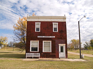
Balfour is a city in McHenry County, North Dakota, United States. The population was 20 at the 2020 census. It is part of the Minot Micropolitan Statistical Area.
Aneta is a city in Nelson County, North Dakota, United States. The population was 234 at the 2020 census. Aneta was first settled in 1882 and incorporated as a city in 1893.
Dwight is a city in Richland County, North Dakota, United States. The population was 80 at the 2020 census. Dwight was founded in 1881. It is part of the Wahpeton, ND–MN Micropolitan Statistical Area.
Rolette is a city in Rolette County, North Dakota, United States. The population was 484 at the 2020 census.
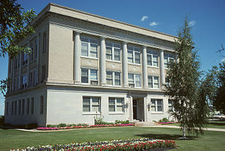
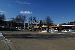
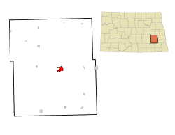
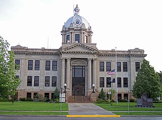
Finley is a city in Steele County, North Dakota. It is the county seat of Steele County. The population was 401 at the 2020 census. Finley was founded in 1897.
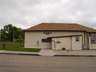
Cleveland is a city in Stutsman County, North Dakota, United States. The population was 57 at the 2020 census.
Bryant is a city in Hamlin County, South Dakota, United States. It is part of the Watertown, South Dakota Micropolitan Statistical Area. The population was 471 at the 2020 census.
Estelline is a city in Hamlin County, South Dakota, United States. It is part of the Watertown, South Dakota Micropolitan Statistical Area. The population was 749 at the 2020 census.
Whitewood is a city in Lawrence County, South Dakota, United States. The population was 879 at the 2020 census.
Selby is a city in Walworth County, South Dakota, United States. The population was 610 at the 2020 census. It is the county seat of Walworth County.
Enderlin is a city in Cass and Ransom counties in the State of North Dakota. The population was 881 at the 2020 census.