Horace, North Dakota

Last updated

Horace, North Dakota
Horace, North Dakota.jpg
Near the grain elevator within Horace
Motto: 
"Horizons Expand Here."
ND Cass County Horace.svg
Location of Horace, North Dakota
Coordinates: 46°45′21″N96°54′28″W / 46.75583°N 96.90778°W / 46.75583; -96.90778
CountryUnited States
State North Dakota
County Cass
Founded1882
Incorporated 1940's
Government
   Mayor Kory Peterson
   Council Member Naomi Burkland
Stephanie Landstrom
Jeff Trudeau
Sarah Veit
Area
[1]
  Total12.669 sq mi (32.813 km2)
  Land12.666 sq mi (32.804 km2)
  Water0.003 sq mi (0.071 km2)
Elevation
[2]
912 ft (278 m)
Population
 (2020) [3]
  Total3,085
  Estimate 
(2023) [4]
5,643
  Density367.0/sq mi (141.8/km2)
Time zone UTC–6 (Central (CST))
  Summer (DST) UTC–5 (CDT)
ZIP Code
58047
Area code 701
FIPS code 38-38900
GNIS feature ID1036095 [2]
Sales tax 7.5% [5]
Website cityofhorace.com

Horace is a city in Cass County, North Dakota, United States. As of the 2020 census, the population was 3,085. [3]

Contents

The city is a suburb of the Fargo-Moorhead metropolitan area. It is the 14th most populous city in North Dakota. Horace was founded in 1882 at a time of widespread European-American settlement in the territory.

History

A post office has been in operation at Horace since 1875. [6] The city is named after Horace Greeley of Chappaqua, New York, editor of the New York Tribune . [7] Greeley encouraged western settlement with the motto "Go West, young man". [8]

The city is bordered on the west by the Sheyenne River, a tributary of the Red River. To reduce damage from seasonal flooding, which sometimes was severe, the state and federal government collaborated on the Sheyenne Diversion Project, constructing a canal and associated support in 1990–1992 to move Sheyenne flood waters to the west and south of Horace, and north past the western side of West Fargo. This has proved its worth, protecting the Sheyenne cities from damage that resulted from the large 1997 Red River flood, which destroyed areas of Grand Forks and East Grand Forks to the north. [9]

Geography

According to the United States Census Bureau, the city has a total area of 12.669 square miles (32.81 km2), of which 12.666 square miles (32.80 km2) is land and 0.003 square miles (0.01 km2) is water. [1]

Demographics

Historical population
CensusPop.Note
1950 190
1960 178−6.3%
1970 27655.1%
1980 49479.0%
1990 66234.0%
2000 91538.2%
2010 2,430165.6%
2020 3,08527.0%
2023 (est.)5,643 [4] 82.9%
U.S. Decennial Census [10]
2020 Census [3]

2020 census

Horace Racial Composition [11]
RaceNumberPercent
White (NH)2,85792.6%
Black or African American (NH)250.8%
Native American (NH)341.1%
Asian (NH)30.1%
Pacific Islander (NH)00.0%
Some Other Race (NH)170.6%
Mixed/Multi-Racial (NH)902.9%
Hispanic or Latino 591.9%
Total3,085100.0%

As of the 2020 census, there were 3,085 people, 1,049 households, and 868 families residing in the county. [12] The population density was 367.3 inhabitants per square mile (141.8/km2). There were 1,101 housing units. The racial makeup of the county was 93.2% White, 0.9% African American, 1.2% Native American, 0.2% Asian, 0.0% Pacific Islander, 0.9% from some other races and 3.7% from two or more races. Hispanic or Latino of any race were 1.9% of the population. [13] 33.9% of residents were under the age of 18, 9.3% were under 5 years of age, and 6.4% were 65 and older.

2010 census

As of the 2010 census, there were 2,430 people, 810 households, and 682 families living in the city. The population density was 225.7 inhabitants per square mile (87.1/km2). There were 826 housing units at an average density of 76.7 per square mile (29.6/km2). The racial makeup of the city was 97.1% White, 0.5% African American, 1.4% Native American, 0.2% Asian, 0.2% from other races, and 0.7% from two or more races. Hispanic or Latino of any race were 0.9% of the population.

There were 810 households, of which 50.1% had children under the age of 18 living with them, 74.4% were married couples living together, 4.4% had a female householder with no husband present, 5.3% had a male householder with no wife present, and 15.8% were non-families. 12.3% of all households were made up of individuals, and 1.4% had someone living alone who was 65 years of age or older. The average household size was 3.00 and the average family size was 3.27.

The median age in the city was 35.6 years. 33.4% of residents were under the age of 18; 5.1% were between the ages of 18 and 24; 29.6% were from 25 to 44; 26.9% were from 45 to 64; and 4.9% were 65 years of age or older. The gender makeup of the city was 50.6% male and 49.4% female.

2000 census

As of the 2000 census, there were 915 people, 300 households, and 248 families living in the city. The population density was 408.7 inhabitants per square mile (157.8/km2). There were 311 housing units at an average density of 138.9 per square mile (53.6/km2). The racial makeup of the city was 98.47% White, 0.11% African American, 0.55% Native American, 0.22% Asian, 0.33% from other races, and 0.33% from two or more races. Hispanic or Latino of any race were 0.33% of the population.

There were 300 households, out of which 55.7% had children under the age of 18 living with them, 68.3% were married couples living together, 10.0% had a female householder with no husband present, and 17.3% were non-families. 11.3% of all households were made up of individuals, and 2.7% had someone living alone who was 65 years of age or older. The average household size was 3.05 and the average family size was 3.29.

In the city, the population was spread out, with 35.7% under the age of 18, 7.0% from 18 to 24, 37.5% from 25 to 44, 15.6% from 45 to 64, and 4.2% who were 65 years of age or older. The median age was 30 years. For every 100 females, there were 92.6 males. For every 100 females age 18 and over, there were 98.0 males.

The median income for a household in the city was $46,510, and the median income for a family was $47,639. Males had a median income of $31,875 versus $20,924 for females. The per capita income for the city was $15,761. About 3.2% of families and 3.9% of the population were below the poverty line, including 3.6% of those under age 18 and 9.5% of those age 65 or over.

Related Research Articles

<span class="mw-page-title-main">Dakota City, Iowa</span> City in Iowa, United States

Dakota City is a city in and the county seat of Humboldt County, Iowa, United States. The population was 759 at the time of the 2020 census. Dakota City shares its western border with the much larger city of Humboldt. It is the least populous county seat in Iowa.

<span class="mw-page-title-main">Horace, Kansas</span> City in Greeley County, Kansas

Horace is a city in Greeley County, Kansas, United States. As of the 2020 census, the population of the city was 102.

<span class="mw-page-title-main">Oslo, Minnesota</span> City in Minnesota, United States

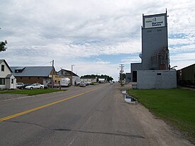
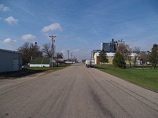
Oslo is a city in Marshall County, Minnesota, United States. The population was 239 at the 2020 census.

<span class="mw-page-title-main">Hettinger, North Dakota</span> City in North Dakota, United States

Hettinger is a city in and the county seat of Adams County, North Dakota, United States. The population was 1,074 at the 2020 census.

<span class="mw-page-title-main">Valley City, North Dakota</span> City in North Dakota, United States

Valley City is a city in and the county seat of Barnes County, North Dakota, United States. The population was 6,575 during the 2020 census, making it the 12th most populous city in North Dakota. Valley City was founded in 1874.

<span class="mw-page-title-main">Bowman, North Dakota</span> City in North Dakota, United States

Bowman is a city in and the county seat of Bowman County, North Dakota, United States. The population was 1,470 at the 2020 census.

<span class="mw-page-title-main">New Rockford, North Dakota</span> City in North Dakota, United States

New Rockford is a city in Eddy County, North Dakota, United States. It is the county seat of Eddy County. The population was 1,361 at the 2020 census. New Rockford was founded in 1883.

<span class="mw-page-title-main">Wishek, North Dakota</span> City in North Dakota, United States

Wishek is a city in McIntosh County, North Dakota, United States. The population was 864 at the 2020 census.

<span class="mw-page-title-main">Washburn, North Dakota</span> City in North Dakota, United States

Washburn is a city in southern McLean County, North Dakota, United States. Located along the upper Missouri River, it is the county seat of McLean County. The population was 1,300 at the 2020 census.

<span class="mw-page-title-main">Aneta, North Dakota</span> City in North Dakota, United States

Aneta is a city in Nelson County, North Dakota, United States. The population was 234 at the 2020 census. Aneta was first settled in 1882 and incorporated as a city in 1893.

<span class="mw-page-title-main">Lisbon, North Dakota</span> City in North Dakota, United States

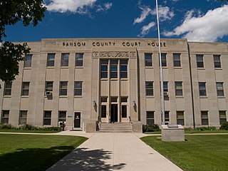
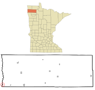
Lisbon is a city in and the county seat of Ransom County, North Dakota, United States. The population was 2,204 at the 2020 census.

<span class="mw-page-title-main">Pisek, North Dakota</span> City in North Dakota, United States

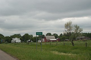
Pisek is a city in Walsh County, North Dakota, United States. The population was 89 at the 2020 census.

<span class="mw-page-title-main">Wagner, South Dakota</span> City in South Dakota, United States

Wagner is a city in Charles Mix County, South Dakota, United States. The population was 1,490 at the 2020 census. The city is served by Wagner Municipal Airport as well as YST Transit buses.

<span class="mw-page-title-main">Blunt, South Dakota</span> City in South Dakota, United States

Blunt is a city in Hughes County, South Dakota, United States. It is part of the Pierre, South Dakota Micropolitan Statistical Area. The population was 342 at the 2020 census.

<span class="mw-page-title-main">Parkston, South Dakota</span> City in South Dakota, United States

Parkston is a city in Hutchinson County, South Dakota, United States. The population was 1,567 at the 2020 census.

<span class="mw-page-title-main">Whitewood, South Dakota</span> City in South Dakota, United States

Whitewood is a city in Lawrence County, South Dakota, United States. The population was 879 at the 2020 census.

<span class="mw-page-title-main">Tea, South Dakota</span> City in South Dakota, United States

Tea is a city in Lincoln County, South Dakota, United States and is a suburb of Sioux Falls. The population was 5,598 at the 2020 census, and was estimated to be 6,918 in 2022.

<span class="mw-page-title-main">Presho, South Dakota</span> City in South Dakota, United States

Presho is a small city in Lyman County, South Dakota, United States. The population was 472 at the 2020 census.

<span class="mw-page-title-main">Viborg, South Dakota</span> City in South Dakota, United States

Viborg is a city in Turner County, South Dakota, United States. The population was 814 at the 2020 census.

<span class="mw-page-title-main">Grandin, North Dakota</span> City in North Dakota, United States

Grandin is a city in Cass and Traill counties in the State of North Dakota, founded in 1881. The population was 186 at the 2020 census. It is now a bedroom community for the nearby Fargo-Moorhead area.

References

  1. 1 2 "2023 U.S. Gazetteer Files". United States Census Bureau. Retrieved May 16, 2024.
  2. 1 2 U.S. Geological Survey Geographic Names Information System: Horace, North Dakota
  3. 1 2 3 "Explore Census Data". United States Census Bureau . Retrieved October 2, 2023.
  4. 1 2 "City and Town Population Totals: 2020-2022". United States Census Bureau. May 16, 2024. Retrieved May 16, 2024.
  5. "Horace (ND) sales tax rate" . Retrieved May 16, 2024.
  6. "Cass County". Jim Forte Postal History. Retrieved October 24, 2015.
  7. Hoheisel, Tim; Nielsen, Andrew R. (2007). Cass County. Arcadia Publishing. p. 82. ISBN   978-0-7385-4145-7.
  8. Josiah Busnell Grinnell (1891). Men and Events of Forty Years. Boston: D. Lothrop. p.  87 . Retrieved February 13, 2009.
  9. "Sheyenne Diversion" Archived November 2, 2016, at the Wayback Machine , City of West Fargo Government website, 2016
  10. "Census of Population and Housing". census.gov. Retrieved June 4, 2015.
  11. "P2 HISPANIC OR LATINO, AND NOT HISPANIC OR LATINO BY RACE – 2020: DEC Redistricting Data (PL 94-171) – Spokane County, Washington".
  12. "US Census Bureau, Table P16: Household Type". United States Census Bureau. Retrieved May 16, 2024.
  13. "How many people live in Horace city, North Dakota". USA Today. Retrieved May 16, 2024.