Grandin, North Dakota

Last updated

Grandin, North Dakota
Grandin, North Dakota - 1864833495.jpg
Street in Grandin, October 2007
ND Cass County Grandin.svg
Location of Grandin, North Dakota
Coordinates: 47°14′12″N97°00′12″W / 47.23667°N 97.00333°W / 47.23667; -97.00333
CountryUnited States
State North Dakota
Counties Cass, Traill
Founded1881
Government
   Mayor Kelly Kyllo
Area
[1]
  Total0.18 sq mi (0.47 km2)
  Land0.18 sq mi (0.47 km2)
  Water0.00 sq mi (0.00 km2)
Elevation
[2]
896 ft (273 m)
Population
 (2020) [3]
  Total186
  Estimate 
(2022) [4]
194
  Density1,027.62/sq mi (396.59/km2)
Time zone UTC-6 (Central (CST))
  Summer (DST) UTC-5 (CDT)
ZIP code
58038
Area code 701
FIPS code 38-32300
GNIS feature ID1036065 [2]

Grandin is a city in Cass and Traill counties in the State of North Dakota, founded in 1881. The population was 186 at the 2020 census. [3] It is now a bedroom community for the nearby Fargo-Moorhead area.

Contents

The farm that belonged to the city namesake brothers was one of the earliest adopters of the telephone in the state. Grandin was the birthplace of the abstract expressionist painter Clyfford Still.

History

Grandin was named for Bonanza farmer John Livingston Grandin. Grandin, a native of Tidioute, Pennsylvania, along with his brother William James, purchased 99 sections of land in the Red River Valley, dividing them in 1,500 acre farms. The brothers had 14,000 acres under cultivation near Grandin, with another 600 acres near Mayville, North Dakota. Prior to the arrival of the railroad the brothers shipped wheat from their farm by barge on the Red River to Fargo, 90 miles downstream. The barges were towed by the steamers Alsop and Grandin. The Grandin brothers' bonanza farm was one of the earliest adopters of the telephone in the state. JL Grandin's great granddaughter is Temple Grandin, an animal scientist, author and autism advocate. [5] [6]

Geography

According to the United States Census Bureau, the city has a total area of 0.17 square miles (0.44 km2), all land. [7]

Demographics

Historical population
CensusPop.Note
1930 172
1940 158−8.1%
1950 156−1.3%
1960 147−5.8%
1970 18727.2%
1980 21012.3%
1990 2131.4%
2000 181−15.0%
2010 173−4.4%
2020 1867.5%
2022 (est.)194 [4] 4.3%
U.S. Decennial Census [8]
2020 Census [3]

2010 census

As of the census of 2010, there were 173 people, 72 households, and 50 families living in the city. The population density was 1,017.6 inhabitants per square mile (392.9/km2). There were 77 housing units at an average density of 452.9 per square mile (174.9/km2). The racial makeup of the city was 95.4% White, 1.7% Native American, 1.2% from other races, and 1.7% from two or more races. Hispanic or Latino of any race were 2.3% of the population.

There were 72 households, of which 31.9% had children under the age of 18 living with them, 59.7% were married couples living together, 5.6% had a female householder with no husband present, 4.2% had a male householder with no wife present, and 30.6% were non-families. 27.8% of all households were made up of individuals, and 8.4% had someone living alone who was 65 years of age or older. The average household size was 2.40 and the average family size was 2.96.

The median age in the city was 38.7 years. 23.1% of residents were under the age of 18; 8.7% were between the ages of 18 and 24; 28.3% were from 25 to 44; 31.3% were from 45 to 64; and 8.7% were 65 years of age or older. The gender makeup of the city was 54.9% male and 45.1% female.

2000 census

As of the census of 2000, there were 181 people, 72 households, and 56 families living in the city. The population density was 1,086.2 inhabitants per square mile (419.4/km2). There were 80 housing units at an average density of 480.1 per square mile (185.4/km2). The racial makeup of the city was 98.90% White, 0.55% Native American, and 0.55% from two or more races. Hispanic or Latino of any race were 1.10% of the population.

There were 72 households, out of which 31.9% had children under the age of 18 living with them, 66.7% were married couples living together, 6.9% had a female householder with no husband present, and 22.2% were non-families. 18.1% of all households were made up of individuals, and 5.6% had someone living alone who was 65 years of age or older. The average household size was 2.51 and the average family size was 2.88.

In the city, the population was spread out, with 27.1% under the age of 18, 5.5% from 18 to 24, 30.4% from 25 to 44, 22.1% from 45 to 64, and 14.9% who were 65 years of age or older. The median age was 38 years. For every 100 females, there were 98.9 males. For every 100 females age 18 and over, there were 109.5 males.

The median income for a household in the city was $40,625, and the median income for a family was $44,063. Males had a median income of $31,667 versus $21,023 for females. The per capita income for the city was $15,973. About 8.8% of families and 11.0% of the population were below the poverty line, including 13.0% of those under the age of eighteen and none of those 65 or over.

Transportation

Amtrak’s Empire Builder , which operates between Seattle/Portland and Chicago, passes through the town on BNSF tracks, but makes no stop. The nearest station is located in Fargo, 30 miles (48 km) to the south.

Related Research Articles

<span class="mw-page-title-main">Grandin, Missouri</span> City in Missouri, United States

Grandin is a city in Carter County, Missouri, United States. The population was 226 at the 2020 census.

<span class="mw-page-title-main">Leal, North Dakota</span> City in North Dakota, United States

Leal is a city in Barnes County in the state of North Dakota. The population was 27 at the 2020 census. Leal was founded in 1892. The name comes from the Scots word for "faithful," which in the phrase laund o the leal means Heaven.

<span class="mw-page-title-main">Amenia, North Dakota</span> City in North Dakota, United States

Amenia is a city in Cass County, North Dakota, United States. The population was 85 at the 2020 census. Amenia was founded in 1880.

<span class="mw-page-title-main">Argusville, North Dakota</span> City in North Dakota, United States

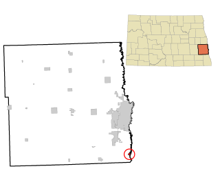
Argusville is a city in Cass County, North Dakota, United States. The population was 480 at the 2020 census. Increasing from 147 two decades earlier due to a huge housing boom from 2004 to 2008. Argusville was founded in 1881.

<span class="mw-page-title-main">Briarwood, North Dakota</span> City in North Dakota, United States

Briarwood is a city in Cass County, North Dakota, United States. The population was 57 at the 2020 census. Briarwood was founded in 1973. It is a suburb directly adjacent to the city of Fargo.

<span class="mw-page-title-main">Frontier, North Dakota</span> City in North Dakota, United States

Frontier is a city in Cass County, North Dakota, United States. The population was 195 at the 2020 census. Frontier is located south of the city of Fargo and is located roughly six miles southwest of that city's downtown. Frontier was founded in 1976. Since Frontier's founding, the adjacent city of Fargo has grown to the point where it almost completely encompasses Frontier's city limits. Only a small gap on the city's southwest corner keeps Frontier from being a complete enclave community within Fargo's border.

<span class="mw-page-title-main">Gardner, North Dakota</span> City in North Dakota, United States

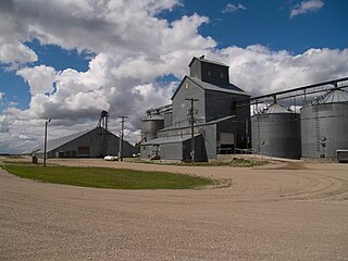
Gardner is a city in Cass County, North Dakota, United States. The population was 129 at the 2020 census.

<span class="mw-page-title-main">Harwood, North Dakota</span> City in North Dakota, United States

Harwood is a city in Cass County, North Dakota, United States. The population was 794 at the 2020 census. It has become a bedroom community of the nearby Fargo-Moorhead area. Harwood was founded in 1881.

<span class="mw-page-title-main">Horace, North Dakota</span> City in North Dakota, United States

Horace is a city in Cass County, North Dakota, United States. As of the 2020 census, the population was 3,085.

<span class="mw-page-title-main">Kindred, North Dakota</span> City in North Dakota, United States

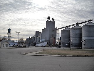
Kindred is a city in Cass County, North Dakota, United States. The population was 889 at the time of the 2020 census. Kindred primarily serves as a bedroom community for Fargo, located about 25 miles to the southwest.

<span class="mw-page-title-main">Mapleton, North Dakota</span> City in North Dakota, United States

Mapleton is a city in Cass County, North Dakota, United States. It sits on the banks of the Maple River. The population was 1,320 at the 2020 census. Mapleton serves as a bedroom community of the Fargo-Moorhead metropolitan area. The core cities are ten miles to the east of Mapleton.

<span class="mw-page-title-main">North River, North Dakota</span> City in North Dakota, United States

North River is a city in Cass County, North Dakota, United States. The population was 55 at the 2020 census. North River was founded in 1973. It is a suburb/bedroom community directly adjacent to the city of Fargo.

<span class="mw-page-title-main">Oxbow, North Dakota</span> City in North Dakota, United States

Oxbow is a city in Cass County, North Dakota, United States. The population was 381 at the 2020 census. It is an upscale bedroom community located 15 miles (24 km) south of Fargo. It was incorporated as a city October 25, 1988.

<span class="mw-page-title-main">Prairie Rose, North Dakota</span> City in North Dakota, United States

Prairie Rose is a city in Cass County, North Dakota, United States. The population was 56 at the 2020 census. The city is an enclave suburb of Fargo. Prairie Rose was founded in 1975 and it was incorporated in 1978. There are 21 homes in the city.

<span class="mw-page-title-main">Inkster, North Dakota</span> City in North Dakota, United States

Inkster is a small village in Grand Forks County, North Dakota, United States, with a population of 38 as of the 2020 census. Inkster was founded in 1884, in an area that had been settled by George T. Inkster in 1878.

<span class="mw-page-title-main">Venturia, North Dakota</span> City in North Dakota, United States

Venturia is a city in McIntosh County, North Dakota, United States. The population was 21 at the 2020 census. Venturia was founded in 1901.

<span class="mw-page-title-main">Petersburg, North Dakota</span> City in North Dakota, United States

Petersburg is a city in Nelson County, North Dakota, United States. The population was 162 at the time of the 2020 census.

<span class="mw-page-title-main">Fort Ransom, North Dakota</span> City in North Dakota, United States

Fort Ransom is a city in Ransom County, North Dakota, United States. The population was 91 at the 2020 census. Fort Ransom was founded in 1880 with the first merchants arriving in 1878.

<span class="mw-page-title-main">Fairmount, North Dakota</span> City in Richland County, North Dakota, United States

Fairmount is a city in Richland County, North Dakota, United States. The population was 343 at the 2020 census. Fairmount was founded in 1884. It is part of the Wahpeton, ND–MN Micropolitan Statistical Area.

<span class="mw-page-title-main">Crooks, South Dakota</span> City in South Dakota, United States

Crooks is a city in Minnehaha County, South Dakota, United States and is a suburb of Sioux Falls. The population was 1,362 at the 2020 census. Crooks was named New Hope until 1904. The town's present name honors W. A. Crooks, a local politician.

References

  1. "ArcGIS REST Services Directory". United States Census Bureau. Retrieved September 20, 2022.
  2. 1 2 U.S. Geological Survey Geographic Names Information System: Grandin, North Dakota
  3. 1 2 3 "Explore Census Data". United States Census Bureau . Retrieved October 24, 2023.
  4. 1 2 "City and Town Population Totals: 2020-2022". United States Census Bureau. October 24, 2023. Retrieved October 24, 2023.
  5. Federal Writer's Project of the Works Progress Administration for the State of North Dakota (1977). The WPA Guide To 1930s North Dakota (2nd ed.). State Historical Society of North Dakota. pp. 193–194. ISBN   1891419145.
  6. Chapter 10 The Legacy Of Genes in "A Thorn in My Pocket: Temple Grandin's Mother Tells the Family Story" by Eustacia Cutler
  7. "US Gazetteer files 2010". United States Census Bureau. Archived from the original on January 25, 2012. Retrieved June 14, 2012.
  8. United States Census Bureau. "Census of Population and Housing" . Retrieved July 21, 2013.