
Lombardy is an administrative region of Italy that covers 23,844 km2 (9,206 sq mi); it is located in the northern-central part of the country and has a population of about 10 million people, constituting more than one-sixth of Italy's population. Over a fifth of the Italian gross domestic product (GDP) is produced in the region.

Lecco is a city of 48,131 inhabitants in Lombardy, northern Italy, 50 kilometres (31 mi) north of Milan. It lies at the end of the south-eastern branch of Lake Como. The Bergamo Alps rise to the north and east, cut through by the Valsassina of which Lecco marks the southern end.

The Ligurian Alps are a mountain range in northwestern Italy. A small part is located in France. They form the south-western extremity of the Alps, separated from the Apennines by the Colle di Cadibona. The Col de Tende and the Vermenagna valley separate them from the Maritime Alps. They form the border between Piedmont in the north and Liguria in the south.

Brianza is a geographical, historical and cultural area of Italy, at the foot of the Alps, in the northwest of Lombardy, between Milan and Lake Como.
Pizzo Tre Signori is a mountain in the Bergamo Alps, with an elevation of 2,554 metres (8,379 ft).

Taburno Camposauro is a massif located in the Apennines, to the west of Benevento, in the Campania region of Southern Italy. Its highest peak is the Taburno, at 1,393 m. It is composed of two groups of calcareous mountains separated by a plain. The fauna is affected by human activities, but the birdlife is very diverse. Several historical structures, mainly religious, are located on the massif. A DOC wine is produced in the area.

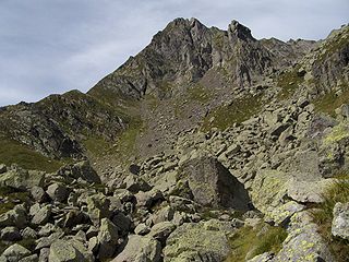
Pizzo Coca is a mountain that straddles the Val Seriana and the Valtellina in Lombardy, Italy. It is the highest peak in the Bergamo Alps. Its height is 3,050 metres with a prominence height of 1,878 metres and a saddle of 1,172 metres. A post-glacial valley exists near a point called "ometto in sassi" at 2,400 meters.
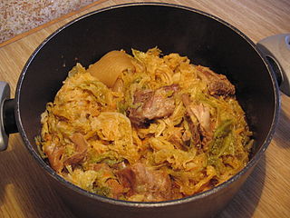
Lombard cusine is a type of northern Italian cuisine. The varied historical events of its provinces and of the diversity of its territories resulted in a very varied culinary tradition. First courses in Lombard cuisine range from risottos to soups and stuffed pasta, in broth or not, and a varied choice of second courses meat dishes are added to fish dishes of the tradition of the many lakes and rivers of Lombardy.

Monte Orsiera is a mountain in the Cottian Alps belonging to the Province of Turin (Italy).

The Alpe Veglia and Alpe Devero Natural Park was established in 1995 and is in the Ossola valley, in the Province of Verbania, Italy.

The Regional Natural Park of the Ligurian Alps is a natural park in Province of Imperia. It was established in 2007 by the legge regionale nr.34 of 15/11/2007.
The Beigua Natural Regional Park is a natural park located in province of Savona and the Metropolitan City of Genoa, both in Liguria (Italy). It's the largest protected area of the region. It gets the name from the highest mountain of the area, Monte Beigua.
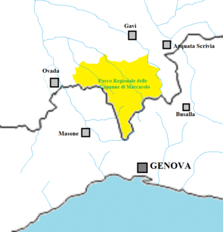
The Capanne di Marcarolo Natural Regional Park is a natural park in the province of Alessandria. It gets the name from a small village in the protected area, Capanne di Marcarolo.

Monte Monega is a 1,882-metre (6,175 ft) mountain of the Ligurian Alps, in Italy.

The Mont Tout Blanc is a 3,438.2 metres high mountain belonging to the Italian side of Graian Alps.

The Punta Leynir is a 3,238 metres high mountain belonging to the Italian side of Graian Alps.

The Cinque Vette Park is a natural park, established by the Region of Lombardy on 19 June 2017. The park is located in the north-eastern part of the Province of Varese, in the Italian region of Lombardy. It takes the name from the main geographic features located in the park, the five mountain peaks. The project was launched with the aim of the three local councils of to preserve a green area and make it available for touristic-sportive-cultural initiatives above 500 meters of altitude. The primary goal of the park is to encourage the discovery of the natural features of the north-eastern part of Varese, which offers panoramic view points and preserves historical aspects such as: the remains of the Cadorna Line; the ruins of the Castle of Cuasso al Monte; the Artistic village of Boarezzo; the Saint Gemolo Abbey; the Alpine Village of Mount Piambello; and, the Hospital of Cuasso Al Monte.

The Adamello Brenta Natural Park is a nature reserve in Trentino, Italy. Established in 1967, it encompasses most of the Adamello-Presanella Alps as well as the Brenta Dolomites; it is the largest natural park in Trentino and along with the adjacent Stelvio National Park, Swiss National Park and Adamello Regional Park, it forms the largest protected area in the Alps, nearly 400,000 hectares. It is a UNESCO Global Geopark since 2008.

The Adamello Regional Park is a nature reserve in Lombardy, Italy. Established in 1983, it encompasses the Lombard portion of the Adamello-Presanella Alps; together with the adjacent Stelvio National Park, Swiss National Park and Adamello Brenta Natural Park, it forms the largest protected area in the Alps, nearly 400,000 hectares.

The Bergamasque Alps Regional Park is a nature reserve in Lombardy, Italy. Established in 1989, it encompasses the Bergamasque Alps, known in Italy as Alpi Orobie; with an area of nearly 70,000 hectares, it is the largest natural park in Lombardy.
