Vasquez Rocks

Last updated

Vasquez Rocks
Vasquez Rocks County Park.jpg
Vasquez Rocks
U.S. - Los Angeles Metropolitan Area location map.svg
Red pog.svg
USA California location map.svg
Red pog.svg
Usa edcp location map.svg
Red pog.svg
Location10700 Escondido Canyon Road
Agua Dulce, California 91390
NRHP reference No. 72000228
Added to NRHPJune 22, 1972

Vasquez Rocks Natural Area Park is a 932-acre (377-hectare) park located in the Sierra Pelona in northern Los Angeles County, California. It is known for its rock formations, the result of sedimentary layering and later seismic uplift. It is located near the town of Agua Dulce, between the cities of Santa Clarita and Palmdale. The area is visible from the Antelope Valley Freeway (State Route 14). Its location approximately 25 miles (40 km) from downtown Los Angeles places it within Hollywood's "studio zone" and makes it a popular filming location for films and television programs.

Contents

History

These rock formations were formed by rapid erosion during uplift about 25 million years ago, and then later exposed by uplift activity along the San Andreas Fault. [1] [2]

The Tataviam people were living here when the Spanish arrived and still live in the region, with a modern tribal government. The village of Mapipinga was located here. [3] Their language was most likely a Takic Uto-Aztecan language. They lived in grass huts within villages. With the coming of the Spanish missions, some of these people were forced to work there. They eventually began speaking Spanish and inter-marrying with other tribes.

In 1874, Tiburcio Vásquez, one of California's most notorious Mexican bandidos , used these rocks to elude capture by law enforcement. His name has since been associated with this geologic feature. [4]

The land and rock formations were acquired gradually by Los Angeles County, beginning with a donation of 40 acres in 1971, with more parcels being added through 2001. [5] The Pacific Crest Trail crosses through the park.

Vasquez Rocks was added to the National Register of Historic Places (site #72000228) in 1972 because of its significance as a prehistoric site for the Shoshone and Tataviam peoples. [6]

Formation

Literature reviews have dated the earliest sedimentation of the Vasquez Formation occurring between the later portion of the Oligocene Epoch to the lower Miocene Epoch, each respectively 33.9-23 million years ago and 23.03-5.3 million years ago. [7] [8] [9]

The Vasquez Formation is located just east of the city of Santa Clarita, Los Angeles County, California, USA. It resides within the Soledad Basin, an orthogonal rift between the Sierra Pelona Mountains to the northwest and the San Gabriel Mountains to the east, which are both within the province of the Transverse Mountain Range of Southern California. [9] The San Andreas Fault runs parallel behind the Sierra Pelona Mountains and separates the formation from the North American Plate.

The Vasquez Formation consists of alluvial sediments that eroded from the Sierra Pelona and San Gabriel Mountains and were deposited in alluvial fans on both sides of the Soledad Basin. [10] Erosion of the sediment included processes like rain, floods, wind, and earthquakes. [10] Over the course of millions of years, the sediment was laid down under alternating lacustrine and fluviatile conditions. [11] Once laid flat across the basin floor, immense pressure converted the layers into sandstone, which became covered with younger sediment deposits. The sediment beds reside in a sharply folded syncline. [11]

Due to its proximity to the San Andreas Fault, tectonic activity has been an important factor in the reshaping, uplift, and exposure of the buried sandstone. The Elkhorn Fault, an offshoot of the San Andreas Fault, runs through the Vasquez Rocks Natural Area Park. [10] Other faults, such as the Pelona, Vasquez Canyon, Soledad, and San Gabriel Faults, are all within proximity of the formation. The most exposed portion of the Vasquez Formation is the oldest tertiary formation within the east portion of the Ventura Basin. [11]

The Vasquez Rocks consist mainly of coarse-grained conglomerate and breccia sediments, which were deposited adjacent to active faults during rapid uplift and consequent erosion of the San Gabriel Mountains. Approximately 25 million years ago (late Oligocene time), the collision of the North American and Pacific tectonic plates uplifted the area along the Elkhorn Fault. [12] Energetic erosion of the highland along with uplift and volcanism caused debris flow sediments to be distributed in alluvial fans into a rapidly subsiding rift known as the Soledad Basin. [9] These sediments were buried and lithified through the Miocene and became exposed more recently via activity along the San Andreas fault system. [13] The strata are now highly tilted and disconnected from their source area. The strata were deformed and offset by the later fault activity. The distinctive hogback ridges of steeply inclined strata serve to graphically demonstrate the significant fault activity in the area. It is possible to see the extreme variance in grain size between layers of sediment where the strata are exposed. These sedimentary rocks, named the Mint Canyon Formation, were laid down about 8-15 million years ago. In the upper layers, many animal fossils have been found, including camels, horses and rodents. [14]

Soil surveyors mapped much of the park as Rock Land with no soil cover; where soil exists the dominant series is Gaviota gravelly loam which ranges from 6 to 20 inches thick. [15]

Ecology

Shaded strands of scrub oak, California juniper, California sagebrush, and short grasses within Vasquez Rocks Sunrise at Vasquez Rocks Nature Area (16000600349).jpg
Shaded strands of scrub oak, California juniper, California sagebrush, and short grasses within Vasquez Rocks

The ecology of the park is characteristic of the California montane chaparral and woodlands ecoregion. The park is primarily covered in short grasses, scrub oak trees, California junipers, yucca, and other chaparral shrubs such as California sagebrush and California buckwheat.

Role in entertainment

A prominent rock formation featured in numerous films and television productions. Vasquez Rocks April 2005.jpg
A prominent rock formation featured in numerous films and television productions.

The park's visually interesting terrain and proximity to Hollywood have made it a frequently used filming location since the 1930s. As it was within the studio zone, union actors and crew could be asked to work there without producers needing to pay extra. [16] Producer Stanley Bergerman chose it to represent Tibet in the film Werewolf of London (1935). [17] It became popular as a setting in westerns in the 1940s and 1950s, followed by numerous television series. [17]

The prominent rock formation is featured as fictional alien settings in four episodes of the original late 1960s Star Trek series, [16] from which it gained the nickname "Kirk's Rock". [18] [19] The location was subsequently used the same way in the films Star Trek IV: The Voyage Home (1986) and Star Trek (2009), and episodes of Star Trek: The Next Generation , Star Trek Voyager , and Star Trek: Enterprise . Star Trek: Picard features scenes set and filmed at Vasquez Rocks, making it the first time the rocks have been seen as themselves in the franchise. [19] Futurama pays homage to its usage in Star Trek in the episode "Where No Fan Has Gone Before", in which most of the original series actors and broadcast tapes are transported to an alien planet whose landscape prominently features rocks modelled after those at Vasquez.

Other feature films shot at Vasquez Rocks include Bill & Ted's Bogus Journey , Amazon Women on the Moon; Dante's Peak; The Muppet Movie ; Hot Shots! Part Deux; Rustlers' Rhapsody; The Flintstones; Short Circuit; Blazing Saddles; Paul; Hail, Caesar!; and Hearts of the West . Other television series include Power Rangers (seasons 1-5) , Zorro , The Fugitive , F Troop , Kung Fu , The A-Team , MacGyver , Roswell , The Big Bang Theory , and GLOW . Commercials for Taco Bell, Bank of America, Pacific Bell, Pepsi, and Nike have been filmed at the rocks. Musicians Radiohead, Michael Jackson, Tom Petty and the Heartbreakers, Greta Van Fleet, 311, Eddie Money, Sammy Kershaw, Restless Heart, Lee Tae-min, and BTS have made music videos there. [20]

Activities

A Pacific Crest Trail sign at Vasquez Rocks Pacific Crest Trail Sign at Vasquez Rocks.jpg
A Pacific Crest Trail sign at Vasquez Rocks

Vasquez Rocks Natural Area Park is open from sunrise to sunset for outdoor activities. [4] The park has equestrian areas, picnic areas, hiking trails, and rock climbing. The Pacific Crest Trail passes through Vasquez Rocks Natural Area Park and can be used for short as well as lengthy hikes. [21] Special events can also be hosted there, such as Star Parties and weddings. [22]

See also

Related Research Articles

<span class="mw-page-title-main">San Gabriel Mountains</span> Mountain range of the Transverse Ranges in California, United States

The San Gabriel Mountains comprise a mountain range located in northern Los Angeles County and western San Bernardino County, California, United States. The mountain range is part of the Transverse Ranges and lies between the Los Angeles Basin and the Mojave Desert, with Interstate 5 to the west and Interstate 15 to the east. The range lies in, and is surrounded by, the Angeles and San Bernardino National Forests, with the San Andreas Fault as its northern border.

<span class="mw-page-title-main">Transverse Ranges</span> Group of mountain ranges of southern California

The Transverse Ranges are a group of mountain ranges of southern California, in the Pacific Coast Ranges physiographic region in North America. The Transverse Ranges begin at the southern end of the California Coast Ranges and lie within Santa Barbara, Ventura, Los Angeles, San Bernardino, Riverside and Kern counties. The Peninsular Ranges lie to the south. The name Transverse Ranges is due to their east–west orientation, making them transverse to the general northwest–southeast orientation of most of California's coastal mountains.

<span class="mw-page-title-main">Santa Clarita Valley</span> Valley in Los Angeles County, California, United States

The Santa Clarita Valley (SCV) is part of the upper watershed of the Santa Clara River in Southern California. The valley was part of the 48,612-acre (19,673 ha) Rancho San Francisco Mexican land grant. Located in Los Angeles County, its main population center is the city of Santa Clarita which includes the neighborhoods of Canyon Country, Newhall, Saugus, and Valencia. Adjacent unincorporated communities include Castaic, Stevenson Ranch, Val Verde, and Valencia.

<span class="mw-page-title-main">Los Angeles Basin</span> Sedimentary basin located along the coast of southern California

The Los Angeles Basin is a sedimentary basin located in Southern California, in a region known as the Peninsular Ranges. The basin is also connected to an anomalous group of east-west trending chains of mountains collectively known as the Transverse Ranges. The present basin is a coastal lowland area, whose floor is marked by elongate low ridges and groups of hills that is located on the edge of the Pacific Plate. The Los Angeles Basin, along with the Santa Barbara Channel, the Ventura Basin, the San Fernando Valley, and the San Gabriel Basin, lies within the greater Southern California region. The majority of the jurisdictional land area of the city of Los Angeles physically lies within this basin.

<span class="mw-page-title-main">Agua Dulce, California</span> Census-designated place in Los Angeles County, California

Agua Dulce is a census-designated place in Los Angeles County, California, United States. It lies at an elevation of 2,526 feet (770 m), northeast of Santa Clarita. The community had a population of 3,342 at the 2010 census and covers a geographic area of about 23 square miles (59 km2). Agua Dulce is on the Pacific Crest Trail. The ZIP code is 91390, and the area code is 661.

<span class="mw-page-title-main">Soledad Canyon</span> Canyon in Los Angeles County, California, United States

Soledad Canyon is a long narrow canyon/valley located in Los Angeles County, California between the cities of Palmdale and Santa Clarita. It is a part of the Santa Clara River Valley, and extends from the top of Soledad Pass to the open plain of the valley in Santa Clarita. The upstream section of the Santa Clara River runs through it.

<span class="mw-page-title-main">Temblor Range</span> Mountain range in the southern California Coastal Ranges

The Temblor Range is a mountain range within the California Coast Ranges, at the southwestern extremity of the San Joaquin Valley in California in the United States. It runs in a northwest-southeasterly direction along the borders of Kern County and San Luis Obispo County. The name of the range is from Spanish temblor meaning "tremor", referring to earthquakes. The San Andreas Fault Zone runs parallel to the range at the base of its western slope, on the eastern side of the Carrizo Plain, while the Antelope Plain, location of the enormous Midway Sunset, South Belridge, and Cymric oil fields, lies to the northeast.

<span class="mw-page-title-main">Tataviam</span> Native American group in Southern California, United States

The Tataviam are a Native American group in Southern California. The ancestral land of the Tataviam people includes northwest present-day Los Angeles County and southern Ventura County, primarily in the upper basin of the Santa Clara River, the Santa Susana Mountains, and the Sierra Pelona Mountains. They are distinct from the Kitanemuk and the Gabrielino-Tongva peoples.

<span class="mw-page-title-main">Elizabeth Lake (Los Angeles County, California)</span> Intermittent lake in Elizabeth Lake, California

Elizabeth Lake is a natural sag pond that lies directly on the San Andreas Fault in the northern Sierra Pelona Mountains, in northwestern Los Angeles County, southern California.

<span class="mw-page-title-main">Sierra Pelona Ridge</span> Mountain range of the Transverse Ranges in California, United States

The Sierra Pelona, also known as the Sierra Pelona Ridge or the Sierra Pelona Mountains, is a mountain ridge in the Transverse Ranges in Southern California. Located in northwest Los Angeles County, the ridge is bordered on the north by the San Andreas fault and lies within and is surrounded by the Angeles National Forest.

<span class="mw-page-title-main">Devil's Punchbowl (Angeles National Forest)</span> Sandstone rock formation in the San Gabriel Mountains of Southern California

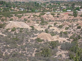
Devil's Punchbowl is a tilted sandstone formation on the northern slopes of the San Gabriel Mountains, in Los Angeles County, California, at an elevation of 4,750 feet (1,450 m).

<span class="mw-page-title-main">San Gabriel Fault</span>

The San Gabriel Fault is a geological fault in Los Angeles County, California, running about 87 miles (140 km) southeastward from the Ridge Basin in the Sierra Pelona-San Emigdio Mountains juncture area to the western San Gabriel Mountains that forms their southwestern face near Sunland and the northeastern San Fernando Valley, and then on the south flank to the southeastern part of the San Gabriel range.

<span class="mw-page-title-main">Coyote Mountains</span> Mountain range in California, United States

The Coyote Mountains are a small mountain range in San Diego and Imperial Counties in southern California. The Coyotes form a narrow ESE trending 2 mi (3.2 km) wide range with a length of about 12 mi (19 km). The southeast end turns and forms a 2 mi (3.2 km) north trending "hook". The highest point is Carrizo Mountain on the northeast end with an elevation of 2,408 feet (734 m). Mine Peak at the northwest end of the range has an elevation of 1,850 ft (560 m). Coyote Wash along I-8 along the southeast margin of the range is 100 to 300 feet in elevation. Plaster City lies in the Yuha Desert about 5.5 mi (8.9 km) east of the east end of the range.

<span class="mw-page-title-main">Hughes Lake (California)</span> Lake in Lake Hughes, California

Hughes Lake is a sag pond on the San Andreas Fault in the northern Sierra Pelona Mountains, in Los Angeles County, California.

Munz Lakes is a small lake located directly on the San Andreas Fault in the northern Sierra Pelona Mountains, within Los Angeles County, California.

<span class="mw-page-title-main">Placerita Canyon State Park</span> State park in Los Angeles County, California, United States

Placerita Canyon State Park is a California State Park located on the north slope of the western San Gabriel Mountains, in an unincorporated rural area of Los Angeles County, near the city of Santa Clarita. The park hosts a variety of historic and natural sites, as well as serving as a trailhead for several hiking trails leading into the San Gabriel Mountains.

<span class="mw-page-title-main">Piercing point</span> Geological feature that is cut by a fault, then moved apart

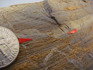
In geology, a piercing point is defined as a feature that is cut by a fault, then moved apart. Reconfiguring the piercing point back in its original position is the primary way geologists can find out the minimum slip, or displacement, along a fault. This can be done on a large scale, a small scale or even a single hand sample/rock.

The San Francisquito Formation is a geologic formation located in northern Los Angeles County, California.

<span class="mw-page-title-main">Geology and geological history of California</span> Description of the geology of California

The geology of California is highly complex, with numerous mountain ranges, substantial faulting and tectonic activity, rich natural resources and a history of both ancient and comparatively recent intense geological activity. The area formed as a series of small island arcs, deep-ocean sediments and mafic oceanic crust accreted to the western edge of North America, producing a series of deep basins and high mountain ranges.

<span class="mw-page-title-main">Vasquez Formation</span> Late Oligocene to Early Miocene sedimentary formation in the Sierra Pelona of California

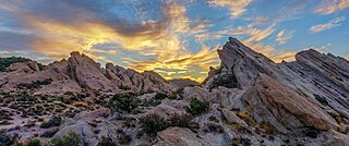
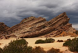
The Vasquez Formation (Tvz) is a geologic formation cropping out at the eponymous Vasquez Rocks in southern California. The formation dates to the Late Oligocene to Early Miocene.

References

  1. Frizzell, VA Jr & Weigand, PW (1993). Whole-rock K-Ar ages and geochemical data from middle Cenozoic volcanic rocks, southern California: A test of correlations across the San Andreas fault in: The San Andreas fault system: displacement, palinspastic reconstruction, and geologic evolution (Matti, Jonathan C.; Powell, R. F.; Weldon, R. J., eds). Boulder, Colo: Geological Society of America. ISBN   0-8137-1178-9.
  2. "A History of Vasquez Rocks and Vicinity". Santa Clarita Valley Historical Society. Archived from the original on July 2, 2016. Retrieved June 26, 2016.
  3. "Mapipinga". Fernandeno Tataviam Band of Mission Indians. Archived from the original on January 7, 2023. Retrieved January 7, 2023.
  4. 1 2 "Vasquez Rocks Natural Area Park". parks.lacounty.gov. County of Los Angeles Department of Parks and Recreation. Archived from the original on January 31, 2013. Retrieved December 26, 2016.
  5. "Touring Vasquez Rocks, A History of its 20th-century Occupation". Archived from the original on September 7, 2016. Retrieved August 24, 2016.
  6. "CALIFORNIA - Los Angeles County". National Register of Historic Places. National Park Service. Archived from the original on January 12, 2008. Retrieved January 7, 2008.
  7. "The Oligocene Epoch". ucmp.berkeley.edu. Archived from the original on April 25, 2015. Retrieved May 8, 2018.
  8. "The Miocene Epoch". ucmp.berkeley.edu. Archived from the original on May 4, 2015. Retrieved May 8, 2018.
  9. 1 2 3 Hendrix; Ingersoll (1987). "Tectonics and alluvial sedimentation of the upper Oligocene/lower Miocene Vasquez Formation, Soledad basin, southern California". Geological Society of America Bulletin. 98 (6): 647–663. Bibcode:1987GSAB...98..647H. doi:10.1130/0016-7606(1987)98<647:taasot>2.0.co;2.
  10. 1 2 3 Brewer, Sarah (2016). "Geology of Vasquez Rocks". SCVHistory.com. Archived from the original on May 9, 2018. Retrieved May 9, 2018.
  11. 1 2 3 Irwin, William P. ""The Vasquez Series in the Upper Tick Canyon Area, Los Angeles County, California."". Archived from the original on April 28, 2018. Retrieved April 28, 2018.
  12. "Southern California Regional Rocks and Roads - Geology of Agua Dulce". January 23, 2009. Archived from the original on May 21, 2023. Retrieved July 2, 2023.
  13. "Vasquez Rocks: Geologic Overview". CSU Long Beach Geology. Archived from the original on February 3, 2013. Retrieved October 28, 2012.
  14. "Geology Trail," handout of County of Los Angeles Department of Parks & Recreation, Vasquez Rocks Natural Area.
  15. https://casoilresource.lawr.ucdavis.edu/gmap/ Archived 2021-11-19 at the Wayback Machine SoilWeb: An Online Soil Survey Browser | California Soil Resource Lab
  16. 1 2 Lewis, Randy (September 8, 2016). "How Vasquez Rocks, L.A.'s onetime outlaw hideout, became 'Star Trek's' favorite alien landscape". Los Angeles Times. Archived from the original on July 25, 2020. Retrieved July 25, 2020.
  17. 1 2 "The True Hollywood Story of The Vasquez Rocks - Hollywood's Favorite Rocky Set ⋆ FilmmakerIQ.com". FilmmakerIQ.com. June 21, 2012. Archived from the original on August 3, 2020. Retrieved May 31, 2018.
  18. "Kirk's Rock : Climbing, Hiking & Mountaineering : SummitPost". www.summitpost.org. Archived from the original on November 11, 2021. Retrieved November 11, 2021.
  19. 1 2 "Star Trek: Picard S1E2 "Maps and Legends"". 25YL. February 2, 2020. Archived from the original on November 11, 2021. Retrieved November 11, 2021.
  20. Cook, Tari, "Filming in Agua Dulce," The 1997 Agua Dulce Chamber of Commerce Business & Community Guide.
  21. "Pacific Crest Trail and Foot Trail Loop in Vasquez Rocks Natural Area Park". hikespeak.com. Archived from the original on January 10, 2017. Retrieved January 10, 2017.
  22. "Vasquez Rocks - Los Angeles (LA) County Parks - Santa Clarita Guide". santaclaritaguide.com. Archived from the original on December 13, 2017. Retrieved May 31, 2018.

Bibliography

34°28′48″N118°19′00″W / 34.479887°N 118.31657°W / 34.479887; -118.31657