
Ventura County is a county in the southern part of the U.S. state of California. As of the 2020 census, the population was 843,843. The largest city is Oxnard, and the county seat is the city of Ventura.

Fillmore is a small city in Ventura County, California, United States, in the Santa Clara River Valley. In an agricultural area with rich, fertile soil, Fillmore has a historic downtown that was established when the Southern Pacific built the railroad through the valley in 1887. The rail line also provided a name for the town: J. A. Fillmore was a general superintendent for the company's Pacific system. The population was 15,002 at the 2010 census, up from 13,643 at the 2000 census.

Santa Paula is a city in Ventura County, California. Situated amid the orchards of the Santa Clara River Valley, the city advertises itself to tourists as the "Citrus Capital of the World". Santa Paula was one of the early centers of California's petroleum industry. The Union Oil Company Building, the founding headquarters of the Union Oil Company of California in 1890, now houses the California Oil Museum. The population was 30,657 at the 2020 census, up from 29,321 at the 2010 census.

The Santa Susana Mountains are a transverse range of mountains in Southern California, north of the city of Los Angeles, in the United States. The range runs east-west, separating the San Fernando Valley and Simi Valley on its south from the Santa Clara River Valley to the north and the Santa Clarita Valley to the northeast. The Oxnard Plain is to the west of the Santa Susana Mountains.

The Santa Clara River is an 83 mi (134 km) long river in Southern California. It drains parts of four ranges in the Transverse Ranges System north and northwest of Los Angeles, then flows west onto the Oxnard Plain and into the Santa Barbara Channel of the Pacific Ocean.

The Santa Clarita Valley (SCV) is part of the upper watershed of the Santa Clara River in Southern California. The valley was part of the 48,612-acre (19,673 ha) Rancho San Francisco Mexican land grant. Located in Los Angeles County, its main population center is the city of Santa Clarita which includes the communities of Canyon Country, Newhall, Saugus, and Valencia. Adjacent unincorporated communities include Castaic, Stevenson Ranch, Val Verde, and the unincorporated parts of Valencia.

State Route 126 is a state highway in the U.S. state of California that serves Ventura and Los Angeles counties. The route runs from U.S. Route 101 in Ventura to Interstate 5 in Santa Clarita through the Santa Clara River Valley. The highway is an important connector highway in Ventura County, and serves as an alternate route into the Santa Clarita Valley, and the San Fernando Valley area of Los Angeles and the High Desert of Antelope Valley.

Canyon Country is a neighborhood in the eastern part of the city of Santa Clarita, in northwestern Los Angeles County, California, United States. It lies along the Santa Clara River between the Sierra Pelona Mountains and the San Gabriel Mountains. It is the most populous of Santa Clarita's four neighborhoods.

The Fillmore and Western Railway is a railroad owned by the Fillmore and Western Railway Company. The company operated on track owned by the Ventura County Transportation Commission. Visitors to Fillmore would see filming activity as well as sets and support equipment at the company's rail yard and along the tracks between Santa Paula and Piru. They stopped operating on the line in 2021.
The Coast Line is a railroad line between Burbank, California and the San Francisco Bay Area, roughly along the Pacific Coast. It is the shortest rail route between Los Angeles and the Bay Area.

The Topatopa Mountains are a mountain range in Ventura County, California, north of Ojai, Santa Paula, and Fillmore. They are part of the Transverse Ranges of Southern California.

The Oxnard Plain is a large coastal plain in southwest Ventura County, California, United States surrounded by the mountains of the Transverse ranges. The cities of Oxnard, Camarillo, Port Hueneme and much of Ventura as well as the unincorporated communities of Hollywood Beach, El Rio, Saticoy, Silver Strand Beach, and Somis lie within the over 200-square-mile alluvial plain (520 km2). The population within the plain comprises a majority of the western half of the Oxnard-Thousand Oaks-Ventura Metro Area and includes the largest city along the Central Coast of California. The 16.5-mile-long coastline (26.6 km) is among the longest stretches of continuous, linear beaches in the state.

Saticoy is an unincorporated community in Ventura County, California, United States. The settlement was laid out in 1887 along the railroad line that was being built from Los Angeles through the Santa Clara River Valley to the town of San Buenaventura. Although the town was 10 miles (16 km) distant at that time, the City of Ventura grew so the community is now just outside the city limits. For statistical purposes, the United States Census Bureau has defined Saticoy as a census-designated place (CDP).
Santa Clarita is a city in northwestern Los Angeles County, California. With a 2020 census population of 228,673, it is the third-largest city by population in Los Angeles County, and the 17th-largest in the state of California. It is located about 30 miles (48 km) northwest of downtown Los Angeles, and occupies 70.75 square miles (183.2 km2) of land in the Santa Clarita Valley, along the Santa Clara River. It is a notable example of a U.S. edge city, satellite city, or boomburb.
Bardsdale is a rural unincorporated community and populated place in Ventura County, California. It is located in the orange blossom and agricultural belt of the Santa Clara River Valley, south of the Santa Clara River and on the north slope of South Mountain. The closest town is Fillmore, which is on the north side of the Santa Clara about 3 miles (5 km) from Bardsdale. Santa Paula is about 7 miles (11 km) west, the most direct route being South Mountain Road. Moorpark is about 6 miles (10 km) south over the serpentine mountain road known as Grimes Canyon.
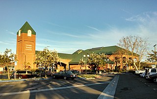
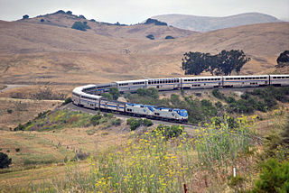
The Oxnard Transit Center, originally known as the Oxnard Transportation Center, is an intermodal transit center in historic downtown Oxnard, California. As a transit hub, the station serves Amtrak and Metrolink trains as well as local and regional buses. Amtrak's Pacific Surfliner from San Luis Obispo to San Diego, Amtrak's Coast Starlight from Los Angeles to Seattle, Washington, and Metrolink's Ventura County Line from Los Angeles Union Station to East Ventura stop here. Ten Pacific Surfliner trains serve the station daily, and six Metrolink trains serve the station each weekday. The Coast Starlight operates one train daily in each direction.
VCTC Intercity is a public transit agency providing bus service in Ventura County, California. It provides an intercity bus service between the cities of Ventura, Oxnard, Camarillo, Thousand Oaks, Moorpark, Santa Paula, and Fillmore in Ventura County, and to communities in neighboring Los Angeles and Santa Barbara counties. The agency is part of the Ventura County Transportation Commission, a governmental body that oversees transportation planning and funding in Ventura County.
Buckhorn is a populated place name along State Route 126 in a rural unincorporated area of Ventura County, California, United States. Buckhorn is about 2 miles (3.2 km) outside the town of Piru but is within the eponymous census-designated place. Located in the Santa Clara River Valley, this was an early stagecoach stop and a regular eating place known for being midway between Los Angeles and Santa Barbara. It was run by the Warring family who came to the county in 1869 and owned the nearby Buckhorn Ranch. Buckhorn was also a station on the initial route of the coast rail line that arrived in the valley in 1887. With the completion of the Santa Susana Tunnel in 1904, the route through Oxnard and Simi Valley became the most direct route between Los Angeles and San Francisco. The shipping of agricultural products such as citrus continued to keep this route busy for many years. The Santa Paula branch line no longer connects through to Santa Clarita after the rails were washed out. The junction with the main line is near the East Ventura station.

The Conejo Grade is a 7% grade incline on a section of US 101. Also known as the Camarillo Grade, it links Thousand Oaks and cities of the Conejo Valley, with Camarillo and the cities on the Oxnard Plain. With a summit elevation of 841.1 feet (256.4 m), California Highway Patrol inspection stations for trucks are situated on both sides of the highway at the upper terminus of the grade.
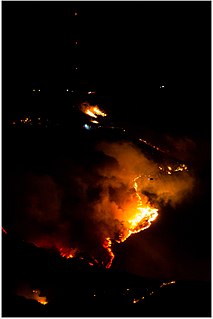
The Maria Fire was a wildfire that burned the south of the community of Santa Paula in the area of Somis, California on the top of South Mountain in Ventura County. The fire ignited in the evening hours of Thursday, October 31, 2019 and consumed well over 4,000 acres (16 km2) within its first several hours of burning. Despite the aggressive initial attack by first responders, the fire exploded rapidly due to a strong Santa Ana wind event that was occurring in the area during its ignition.


