
Grass Valley is a city in Nevada County, California, United States. As of the 2010 United States Census, its population was 12,860. Situated at roughly 2,500 feet (760 m) in elevation in the western foothills of the Sierra Nevada mountain range, this northern Gold Country city is 57 miles (92 km) by car from Sacramento and 88 miles (142 km) west of Reno.

Hydraulic mining is a form of mining that uses high-pressure jets of water to dislodge rock material or move sediment. In the placer mining of gold or tin, the resulting water-sediment slurry is directed through sluice boxes to remove the gold. It is also used in mining kaolin and coal.

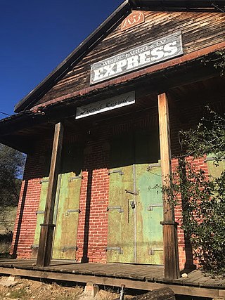
Malakoff Diggins State Historic Park is a state park unit preserving Malakoff Diggins, the largest hydraulic mining site in California, United States. The mine was one of several hydraulic mining sites at the center of the 1882 landmark case Woodruff v. North Bloomfield Mining and Gravel Company. The mine pit and several Gold Rush-era buildings are listed on the National Register of Historic Places as the Malakoff Diggins-North Bloomfield Historic District. The "canyon" is 7,000 feet (2,100 m) long, as much as 3,000 feet (910 m) wide, and nearly 600 feet (180 m) deep in places. Visitors can see huge cliffs carved by mighty streams of water, results of the mining technique of washing away entire mountains of gravel to wash out the gold. The park is 26 miles (42 km) north-east of Nevada City, California, in the Gold Rush country. The 3,143-acre (1,272 ha) park was established in 1965.

State Route 49 is a north–south state highway in the U.S. state of California that passes through many historic mining communities of the 1849 California gold rush and it is known as the Golden Chain Highway. The highway's creation was lobbied by the Mother Lode Highway Association, a group of locals and historians seeking a single highway to connect many relevant locations along the Gold Rush to honor the 49ers. One of the bridges along SR 49 is named for the leader of the association, Archie Stevenot.

The Yuba River is a tributary of the Feather River in the Sierra Nevada and eastern Sacramento Valley, in the U.S. state of California. The main stem of the river is about 40 miles (64 km) long, and its headwaters are split into three major forks. The Yuba River proper is formed at the North Yuba and Middle Yuba rivers' confluence, with the South Yuba joining a short distance downstream. Measured to the head of the North Yuba River, the Yuba River is just over 100 miles (160 km) long.

Camptonville is a small town and census-designated place (CDP) located in northeastern Yuba County, California. The town is located 36 miles (58 km) northeast of Marysville, off Highway 49 between Downieville and Nevada City. It is located on a ridge between the North Fork and Middle Fork of the Yuba River, not far from New Bullards Bar Dam Reservoir. Camptonville lies at an elevation of 2825 feet. The population was 158 at the 2010 census.

Area code 530 is a telephone area code in the North American Numbering Plan (NANP) in northeastern and Northern California. It was created in 1997 in an area code split of 916.
The Spenceville Wildlife Area is an 11,448-acre (46.33 km2) wildlife preserve managed by the California Department of Fish and Wildlife. It is located in the Sierra Nevada Foothills, within Nevada County and Yuba County of northern California.
French Corral is an unincorporated community approximately five miles west of California State Highway 49 in Nevada County, California, United States.

The Sierra Foothills AVA is an American Viticultural Area in the foothills of the Sierra Nevada in the U.S. state of California in the United States. Wine grapes were introduced to the area in the nineteenth century during the California Gold Rush. Over 100 wineries are located within its boundaries.

The Bear River is a tributary of the Feather River in the Sierra Nevada, winding through four California counties: Yuba, Sutter, Placer, and Nevada. About 73 miles (117 km) long, the river flows generally southwest through the Sierra then west through the Central Valley, draining a narrow, rugged watershed of 295 square miles (760 km2).
Browns Valley is an unincorporated community in Yuba County, California. Browns Valley is located 12 miles (19 km) northeast of Marysville and is near Collins Lake.
Orleans Flat was a historic mining town located on the San Juan Ridge about 20 miles northeast of Nevada City, California and about 5 miles northeast of North Bloomfield, California. The town was about 1 mile south of the Middle Yuba River at an elevation of about 4200 ft. To the west lay the mining towns of Moore's Flat and Woolsey's Flat, each about I mile apart. All three were settled around 1851 and their histories frequently intertwine. Collectively, they are sometimes referred to as "The Flats." All three were part of Eureka Township.
Woolsey Flat or Woolsey's Flat was a historic mining town located on the San Juan Ridge, located about 17 miles northeast of Nevada City and about 3 miles northeast of North Bloomfield. The town was about 1 mile south of the Middle Yuba at an elevation of about 4200 ft. To the east lay the mining towns of Moore's Flat and Orleans Flat, each about I mile apart. All three were settled in 1851 and their histories frequently intertwine. Collectively, they are sometimes referred to as "The Flats. All three were part of Eureka Township.
Snow Point was a historic mining town in Nevada County, California on the San Juan Ridge about 2 miles east of Moore's Flat and about 6 miles west of Graniteville. It was located at an elevation of 4321 ft just off present day German Bar Road about midway between that road's intersections with present day Moore's Flat Road and Hagerty Road.

Blue Tent is a historic 19th century gold mining community located about six miles northeast of Nevada City, California.
Mooney Flat was an important mining and transportation hub in western Nevada County, California, just east of the Yuba County line. It was situated on modern Mooney Flat Road, about 1 mile north of modern Highway 20, at an elevation of about 800 ft.
Henness Pass, elevation 6,916 ft (2,108 m), is a mountain pass northwest of Reno on the crest of the Sierra Nevada range in Sierra County, California. The pass is traversed by Henness Pass Road, a mostly unpaved road not generally passable by automobiles in winter. Portions of the road are recommended for high clearance vehicles only.

The Sac-Joaquin Section (SJS) is the governing body of public and private high school athletics in parts of Northern San Joaquin Valley, California. Its geographic area also covers the California portion of the Lake Tahoe region; however, three schools in that area—North Tahoe, Truckee, and South Tahoe High Schools—are instead members of the Nevada Interscholastic Activities Association due to their relative isolation from other California schools and their proximity to more populated areas in Nevada, especially in the Reno area. It is one of ten sections that compose the California Interscholastic Federation (CIF). The SJS is split into seven divisions, each comprising several leagues.

The case of Woodruff v. North Bloomfield Gravel Mining Company was a lawsuit brought to California courts in 1882 where a group of local farmers sued North Bloomfield Mining and Gravel Company over damages caused to farmland in the Central Valley. The farmers who brought the suit claimed that the company's hydraulic mining operations resulted in the disposal of excess sediment, debris, and chemicals in local rivers. Prosecutors argued that the debris raised river beds and restricted flow in the rivers leading to heavy man-made flooding. In the years prior, flooding of debris and chemicals had destroyed a large portion of the valley's agriculture.


