Tri-Valley

Last updated
Tri-Valley
Area of the East Bay
Tri-Valley Landscape.jpg
Tri-Valley Landscape
Tri Valley Location.png
Tri-Valley location in California
Usa edcp location map.svg
Red pog.svg
Tri-Valley
Location in the United States
Coordinates: 37°39′45″N121°52′29″W / 37.66250°N 121.87472°W / 37.66250; -121.87472
Population
  Total361,000
Time zone UTC-8 (Pacific Time Zone)
  Summer (DST) UTC-7 (PDT)

The Tri-Valley area is grouping of three valleys in the East Bay region of California's Bay Area. The three valleys are Amador Valley, San Ramon Valley, and Livermore Valley. The Tri-Valley encompasses the cities of Dublin, Livermore, Pleasanton and San Ramon, the town of Danville and the CDPs of Alamo, Blackhawk and Diablo. The area is known for its Mediterranean climate, wineries, and nature. It is primarily suburban in character. The United States Census Bureau defines an urban area centered in the cities of Livermore, Pleasanton, and Dublin with a 2020 population of 240,381, ranked 167th in the United States in terms of population. [1] The total population of the area is estimated to be 361,000. [2] It offers more affordable living accommodations than the cities of San Francisco and San Jose. [3] [4]

Contents

History

The Ohlone tribe settled the area circa 2000 BC, particularly in the northern part of Pleasanton. In AD 1772, however, Spanish settlers involved with the nearby mission work at Mission San Jose restructured the Ohlone way of life. [5] [6]

The area began to be developed when the Gold Rush ended. During this period, the area went from being marshland to agricultural. [7]

Climate

The climate of the Tri-Valley is mild. Most rain falls in the winter. Snow almost never occurs, although it sometimes falls on the tops of surrounding mountains, especially Mt. Diablo. Summer days are in the 80s to over 100 °F, but nights are often cool. In winter, daytime temperatures reach the 50s and 60s, while nights are in the 30s and 40s, dipping on rare occasions into the 20s. Mean annual rainfall ranges from about 14 in (360 mm) in Livermore to 23 in (580 mm) in Alamo. [8]

Transportation

The Tri-Valley is serviced by WHEELS, operated by the Livermore Amador Valley Transit Authority (LAVTA), a bus agency that operates local bus service throughout Livermore, Pleasanton and Dublin, including service to Hacienda Business Park, Lawrence Livermore National Laboratory, Las Positas College, Stoneridge Mall, the West Dublin/Pleasanton BART Station and the Dublin/Pleasanton BART station.

Two major highways, Interstates 580 and 680 cross the Tri-Valley area. Interstate 580 runs east-west, connecting the area to the Central Valley to the east and the North Bay area to the west. Interstate 680 runs north-south, connecting the area to the South Bay area in the south, and the Concord-Walnut Creek area in the north. The two interstates cross on the border of Dublin and Pleasanton.

The Tri-Valley area is also serviced by BART, offering service to the rest of the San Francisco Bay Area via two stops: West Dublin/Pleasanton and the Dublin/Pleasanton terminus station. [9] The West Dublin/Pleasanton Station opened in 2011, and was the first infill station on an existing line. In 2018, BART cancelled plans [10] to extend the line to Livermore. However, the Tri-Valley San Joaquin Valley Regional Rail Authority is in the planning process [11] for a rail connection between BART, ACE, and the San Joaquin Valley.

Corporate office buildings at the intersection of I-580 and I-680 Tri-Valley-Offices.jpg
Corporate office buildings at the intersection of I-580 and I-680

Economy

The Tri-Valley is home to the corporate headquarters of many companies, including 10X Genomics, 24 Hour Fitness, Architectural Glass and Aluminum, Bay Area News Group, Blackhawk Network Holdings, CallidusCloud, Chevron, The Cooper Companies, Discovery Toys, Ellie Mae, GE Digital, Gillig Corporation, Patelco Credit Union, Prosoft Engineering, Ross Stores, SafeAmerica Credit Union, Safeway, Shaklee, TriNet, Veeva Systems, Visioneer, WANdisco, The Wine Group, Product10x Accelerator, Salestable and Workday.

Major employment centers include Bishop Ranch and Hacienda Business Park.

Lawrence Livermore National Laboratory and Sandia National Laboratories are also major employers in the region.

Aerial view of Schaefer Ranch Park in Dublin, CA Schaefer Ranch Park.jpg
Aerial view of Schaefer Ranch Park in Dublin, CA

Recreation

The Tri-Valley features access to many recreational options, including Alviso Adobe Community Park, Blackhawk Museum, Brushy Peak Regional Preserve, Del Valle Regional Park, Dublin Hills Regional Park, Eugene O'Neill National Historic Site, Forest Home Farms, Iron Horse Regional Trail, Las Trampas Regional Wilderness, Little Hills Picnic Ranch, Livermore Valley Wine Country, Morgan Territory Regional Preserve, Mount Diablo State Park, Pleasanton Ridge Regional Park, Shadow Cliffs Regional Recreation Area and The Wave Waterpark.

See also

Related Research Articles

<span class="mw-page-title-main">Alameda County, California</span> County in California, United States

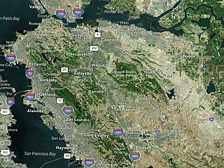
Alameda County is a county located in the U.S. state of California. As of the 2020 census, the population was 1,682,353, making it the 7th-most populous county in the state and 21st most populous nationally. The county seat is Oakland. Alameda County is in the San Francisco Bay Area, occupying much of the East Bay region.

<span class="mw-page-title-main">Contra Costa County, California</span> County in California, United States

Contra Costa County is a county located in the U.S. state of California, in the East Bay of the San Francisco Bay Area. As of the 2020 United States Census, the population was 1,165,927. The county seat is Martinez. It occupies the northern portion of the East Bay region of the San Francisco Bay Area and is primarily suburban. The county's name refers to its position on the other side of the bay from San Francisco. Contra Costa County is included in the San Francisco–Oakland–Berkeley, CA Metropolitan Statistical Area.

<span class="mw-page-title-main">Dublin, California</span> City in California, United States

Dublin is a suburban city of the East Bay in California. It is located within the Amador Valley of Alameda County's Tri-Valley region. It is located along the north side of Interstate 580 at the intersection with Interstate 680, roughly 35 miles (56 km) east of downtown San Francisco, 23 miles (37 km) east of downtown Oakland, and 31 miles (50 km) north of downtown San Jose.

<span class="mw-page-title-main">Livermore, California</span> City in California, United States

Livermore is a city in Alameda County, California. With a 2020 population of 87,955, Livermore is the most populous city in the Tri-Valley, giving its name to the Livermore Valley. It is located on the eastern edge of California's San Francisco Bay Area, making it the easternmost city in the area. The current mayor is John Marchand.

<span class="mw-page-title-main">Pleasanton, California</span> City in the San Francisco Bay Area

Pleasanton is a city in Alameda County, California, United States. Located in the Amador Valley, it is a suburb in the East Bay region of the San Francisco Bay Area. The population was 79,871 at the 2020 census. In 2005 and 2007, Pleasanton was ranked the wealthiest middle-sized city in the United States by the Census Bureau. Pleasanton is home to the headquarters of Safeway, Workday, Ellie Mae, Roche Molecular Diagnostics, Blackhawk Network Holdings, and Veeva Systems. Other major employers include Kaiser Permanente, Oracle and Macy's. Although Oakland is the Alameda County seat, a few county offices are located in Pleasanton. The Alameda County Fairgrounds are located in Pleasanton, where the county fair is held during the last week of June and the first week of July. Pleasanton Ridge Regional Park is located on the west side of town.

<span class="mw-page-title-main">San Ramon, California</span> City in California, United States

San Ramon is a city in Contra Costa County, California, United States, located within the San Ramon Valley, and 34 miles (55 km) east of San Francisco. San Ramon's population was 84,605 per the 2020 census, making it the 4th largest city in Contra Costa County, behind Richmond, Concord and Antioch.

<span class="mw-page-title-main">Interstate 580 (California)</span> Interstate highway in California

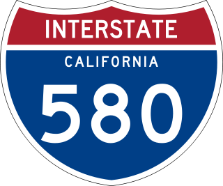
Interstate 580 (I-580) is an approximately 76-mile-long (122 km) east–west auxiliary Interstate Highway in Northern California. The heavily traveled spur route of I-80 runs from US Route 101 (US 101) in San Rafael in the San Francisco Bay Area to I-5 at a point outside the southern city limits of Tracy in the Central Valley. I-580 forms a concurrency with I-80 between Albany and Oakland, the latter of which is the location of the MacArthur Maze interchange immediately east of the San Francisco–Oakland Bay Bridge. I-580 provides a connection from the Bay Area to the southern San Joaquin Valley and Southern California via I-5, as I-5 bypasses the Bay Area to the east.

<span class="mw-page-title-main">Wheels (California)</span>

Wheels is a public bus service in the Tri-Valley region (southeast Alameda County) of the San Francisco Bay Area in California, United States. It is operated by the Livermore Amador Valley Transit Authority (LAVTA). Wheels operates local and limited-stop service in Dublin, Pleasanton, and Livermore, with limited service into Contra Costa County along Interstate 680. The LAVTA was formed in 1985; service began in Dublin and Pleasanton in 1986. In 1987, it took over the 1978-opened Rideo service in Livermore. In 2022, the system had a ridership of 1,019,400, or about 4,100 per weekday as of the second quarter of 2023.

<span class="mw-page-title-main">East Bay</span> Eastern region of the San Francisco Bay Area, California, US

<span class="mw-page-title-main">Iron Horse Regional Trail</span> Multi-use trail in East Bay, California

The San Ramon Valley is a valley and region in Contra Costa County and Alameda County, in the East Bay region of the San Francisco Bay Area in northern California.

<span class="mw-page-title-main">Dublin/Pleasanton station</span> Rapid transit station in Pleasanton, California, US

Dublin/Pleasanton station is a Bay Area Rapid Transit (BART) station on the border of Dublin and Pleasanton in California. It is the eastern terminus of the Blue Line. It is also a major bus terminal served by six providers.

<span class="mw-page-title-main">Area code 925</span> Area code in California, United States

Area code 925 is a telephone area code in the North American Numbering Plan for a northern part of the U.S. state of California. It was created in an area code split of area code 510 in 1998. The numbering plan area comprises the inland portions of the East Bay counties of Alameda and Contra Costa.

<span class="mw-page-title-main">West Dublin/Pleasanton station</span> Rapid transit station in San Francisco Bay Area

West Dublin/Pleasanton is a Bay Area Rapid Transit (BART) station on the border of Dublin and Pleasanton in California, located in the median of I-580. It opened as an infill station on the Blue Line on February 19, 2011 — fourteen years after the rest of the line.

<span class="mw-page-title-main">Livermore station</span> Train stop for Altamont Commuter Express

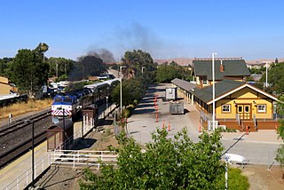
Livermore is a train station in downtown Livermore, California.

Throughout the history of Bay Area Rapid Transit, there have been plans to extend service to other areas.

Amador Valley is a valley in eastern Alameda County, California and is the location of the cities of Dublin and Pleasanton. Part of Tri-Valley, the valley is bounded by the foothills of the Diablo Range on the north and south, Pleasanton Ridge to the west, and Livermore Valley to the east.

<span class="mw-page-title-main">Tri-Valley-San Joaquin Valley Regional Rail Authority</span> Transportation authority in northern California

The Tri-Valley-San Joaquin Valley Regional Rail Authority is a special-purpose district body formed for the sole purpose of providing a public transit connection, known as Valley Link, between broad-gauge Bay Area Rapid Transit (BART) and standard-gauge Altamont Corridor Express (ACE) services, in Northern California.

Southfront Road is a planned railway station in Livermore, California. It is a stop on the planned Valley Link system. Rush hour short turn Valley Link trains would operate from here to Dublin/Pleasanton. Service is expected to start as early as 2028.

Isabel station is a planned railway station in Livermore, California. It is expected to open in 2028 as a stop for Valley Link. The station's parking lot and bus bays are located on the north side of East Airway Boulevard while the platforms and rails are located in the median strip of Interstate 580 just east of Isabel Avenue.

References

  1. "List of 2020 Census Urban Areas". census.gov. United States Census Bureau. Retrieved January 7, 2023.
  2. "Tri-Valley Boomtowns | Getaways | diablomag.com".
  3. CBS (2017). "10 Most Expensive Cities in America". CBS.
  4. CBS (2017). "10 Most Expensive Cities in America". CBS.
  5. "Chapter 9. Ohlone/Costanoans in the United States, 1847-1927" (PDF). Retrieved 11 February 2023.
  6. "History of Pleasanton". pleasanton.com. Archived from the original on November 8, 2017. Retrieved 2018-01-01.
  7. "History of Pleasanton". Museum on Main. Retrieved 2018-01-01.
  8. "Cooperative Climatological Data Summaries". Western Regional Climate Center. Retrieved 2018-11-24.
  9. "Station List | bart.gov". www.bart.gov. Retrieved 2018-01-01.
  10. "Livermore Extension | bart.gov". www.bart.gov. Retrieved 2019-06-13.
  11. "ValleyLink". www.acetobart.org. Retrieved 2019-06-13.