Venice, Florida | |
---|---|
Nickname: Shark Tooth Capital of the World [1] | |
Motto: "City on the Gulf" [2] | |
Coordinates: 27°6′N82°26′W / 27.100°N 82.433°W | |
Country | United States |
State | Florida |
County | Sarasota |
Horse and Chaise | 1800s |
Venice | 1888 |
Incorporated | May 9, 1927, by the Brotherhood of Locomotive Engineers |
Named for | Venice, Italy |
Area | |
• City | 17.78 sq mi (46.05 km2) |
• Land | 16.13 sq mi (41.77 km2) |
• Water | 1.65 sq mi (4.28 km2) |
Elevation | 10 ft (3 m) |
Population (2020) | |
• City | 25,463 |
• Density | 1,578.71/sq mi (609.54/km2) |
• Metro | 833,716 (US: 71st) |
• Metro density | 542.0/sq mi (209.3/km2) |
Time zone | UTC−5 (Eastern (EST)) |
• Summer (DST) | UTC−4 (EDT) |
ZIP codes | 34284-34287, 34290-34293 |
Area code | 941 |
FIPS code | 12-73900 [4] |
GNIS feature ID | 0292749 [5] |
Website | venicegov.com |
Venice is a city in Sarasota County, Florida, United States. The city includes what locals call "Venice Island", a portion of the mainland that is accessed via bridges over the artificially created Intracoastal Waterway. The city is located in Southwest Florida. [6] As of the 2020 Census, the city had a population of 25,463, [7] up from 20,748 at the 2010 Census. [8] Venice is part of the North Port–Bradenton–Sarasota, Florida Metropolitan Statistical Area.
The area that is now Venice was originally the home of Paleo-Indians, with evidence of their presence dating back to 8200 BCE. [9] As thousands of years passed, and the climate changed and some of the Pleistocene animals that the Indians hunted became extinct, the descendants of the Paleo-Indians found new ways to create stone and bone weapons to cope with their changing environment. These descendants became known as the Archaic peoples. Evidence of their camps along with their stone tools were discovered in parts of Venice. [10] Over several millennia the culture and people who lived in the area changed. The peoples who the Spanish encountered when they arrived in 1500s were mound-builders. Venice lay in a boundary area between two cultures, the Tocobaga and the Calusa, and so you can find evidence of each in the area. [11]
The 1800s is when the area saw the first wave of "European" settlers. Venice was first known as Horse and Chaise because of a carriage-like tree formation that marked the spot for fishermen. In the 1870s, Robert Rickford Roberts established a homestead near a bay that bears his name today, Roberts Bay. [12] Francis H. "Frank" Higel, originally from France, arrived in Venice in 1883 with his wife and six sons. He purchased land in the Roberts' homestead for $2,500, equivalent to $82,000in 2023 [13] , to set up his own homestead. Higel established a citrus operation involving the production of several lines of canned citrus items, such as jams, pickled orange peel, lemon juice, and orange wine. [14] Higel established a post office in 1885 with the name Eyry as a service for the community's thirty residents. In February he was appointed as postmaster but the office was shut down months later, in November 1885, with services moving back to Osprey. In 1888, another post office was established, this time with the name Venice, a name Higel himself suggested because of its likeness to the canal city in Italy. [15] [16]
During the Florida land boom of the 1920s, Fred H. Albee, an orthopedic surgeon renowned for his bone-grafting operations, bought 112 acres (45 ha) from Bertha Palmer to develop Venice. [12] He hired John Nolen to plan the city and create a master plan for the streets. Albee sold the land to the Brotherhood of Locomotive Engineers and retained Nolen as city planner. The first portions of the city and infrastructure were constructed in 1925–1926. [17]
In 1926, a fire department was formed with thirty-two volunteers. In that same year, the Brotherhood of Locomotive Engineers purchased a new American LaFrance fire engine from Moore Haven that had been damaged in the Great Miami Hurricane. [18]
The first library was also founded in 1926 by the Venice-Nokomis Women's Club. This "library" was a few books on a shelf in a local store. The library had several temporary homes until 1965 when the Venice Area Public Library was built. [19] [20] This building remained in use until it was demolished in 2017 due to mold. A new library was constructed in 2018 called the William H. Jervey, Jr. Venice Library, named after a benefactor of the new building. [21]
According to the United States Census Bureau, the city has a total area of 16.6 square miles (43.1 km2), of which 15.3 square miles (39.5 km2) is land and 1.4 square miles (3.5 km2), or 8.19%, is water. [8] The climate of Venice is humid subtropical, bordering very closely on a tropical savanna climate, thus featuring pronounced wet and dry seasons.
Climate data for Venice, Florida, 1991–2020 normals, extremes 1927–present | |||||||||||||
---|---|---|---|---|---|---|---|---|---|---|---|---|---|
Month | Jan | Feb | Mar | Apr | May | Jun | Jul | Aug | Sep | Oct | Nov | Dec | Year |
Record high °F (°C) | 89 (32) | 89 (32) | 90 (32) | 95 (35) | 98 (37) | 100 (38) | 100 (38) | 99 (37) | 99 (37) | 97 (36) | 91 (33) | 89 (32) | 100 (38) |
Mean maximum °F (°C) | 83.3 (28.5) | 84.1 (28.9) | 86.9 (30.5) | 90.1 (32.3) | 93.9 (34.4) | 95.4 (35.2) | 95.5 (35.3) | 96.1 (35.6) | 94.8 (34.9) | 92.5 (33.6) | 88.1 (31.2) | 84.3 (29.1) | 96.9 (36.1) |
Mean daily maximum °F (°C) | 72.4 (22.4) | 75.0 (23.9) | 77.9 (25.5) | 82.5 (28.1) | 87.3 (30.7) | 89.9 (32.2) | 91.5 (33.1) | 91.5 (33.1) | 90.0 (32.2) | 85.8 (29.9) | 80.0 (26.7) | 75.0 (23.9) | 83.2 (28.4) |
Daily mean °F (°C) | 62.0 (16.7) | 64.6 (18.1) | 67.7 (19.8) | 72.5 (22.5) | 77.5 (25.3) | 81.4 (27.4) | 82.9 (28.3) | 83.1 (28.4) | 81.6 (27.6) | 76.6 (24.8) | 69.9 (21.1) | 64.9 (18.3) | 73.7 (23.2) |
Mean daily minimum °F (°C) | 51.6 (10.9) | 54.2 (12.3) | 57.5 (14.2) | 62.5 (16.9) | 67.8 (19.9) | 72.9 (22.7) | 74.3 (23.5) | 74.7 (23.7) | 73.2 (22.9) | 67.5 (19.7) | 59.7 (15.4) | 54.8 (12.7) | 64.2 (17.9) |
Mean minimum °F (°C) | 34.3 (1.3) | 37.7 (3.2) | 42.9 (6.1) | 50.3 (10.2) | 59.1 (15.1) | 68.3 (20.2) | 70.8 (21.6) | 71.5 (21.9) | 68.6 (20.3) | 54.9 (12.7) | 46.2 (7.9) | 39.8 (4.3) | 32.7 (0.4) |
Record low °F (°C) | 23 (−5) | 26 (−3) | 31 (−1) | 38 (3) | 49 (9) | 56 (13) | 62 (17) | 65 (18) | 60 (16) | 36 (2) | 29 (−2) | 22 (−6) | 22 (−6) |
Average precipitation inches (mm) | 2.68 (68) | 2.00 (51) | 2.97 (75) | 2.47 (63) | 3.25 (83) | 7.81 (198) | 7.39 (188) | 8.34 (212) | 7.16 (182) | 3.35 (85) | 1.54 (39) | 2.31 (59) | 51.27 (1,302) |
Average precipitation days (≥ 0.01 in) | 7.5 | 5.4 | 5.9 | 5.3 | 6.5 | 12.2 | 14.9 | 16.0 | 14.4 | 8.1 | 4.7 | 6.4 | 107.3 |
Source: NOAA [22] [23] |
Census | Pop. | Note | %± |
---|---|---|---|
1930 | 309 | — | |
1940 | 507 | 64.1% | |
1950 | 727 | 43.4% | |
1960 | 3,444 | 373.7% | |
1970 | 6,648 | 93.0% | |
1980 | 12,153 | 82.8% | |
1990 | 16,922 | 39.2% | |
2000 | 17,764 | 5.0% | |
2010 | 20,748 | 16.8% | |
2020 | 25,463 | 22.7% | |
U.S. Decennial Census [24] |
Race | Pop 2010 [25] | Pop 2020 [26] | % 2010 | % 2020 |
---|---|---|---|---|
White (NH) | 19,762 | 23,466 | 95.25% | 92.16% |
Black or African American (NH) | 113 | 172 | 0.54% | 0.68% |
Native American or Alaska Native (NH) | 24 | 29 | 0.12% | 0.11% |
Asian (NH) | 152 | 244 | 0.73% | 0.96% |
Pacific Islander or Native Hawaiian (NH) | 3 | 5 | 0.01% | 0.02% |
Some other race (NH) | 14 | 62 | 0.07% | 0.24% |
Two or more races/Multiracial (NH) | 129 | 540 | 0.62% | 2.12% |
Hispanic or Latino (any race) | 551 | 945 | 2.66% | 3.71% |
Total | 20,748 | 25,463 | 100.00% | 100.00% |
As of the 2020 United States census, there were 25,463 people, 12,521 households, and 6,810 families residing in the city. [27]
In 2020, there was a population of 25,41.2% of the population were under 5 years old, 6.4% were under 18 years old, and 61.9% was 65 years and older. 3,204 veterans lived in the city and 9.5% of the population were foreign born persons. 54.6% of the population were female persons.
In 2020, the median household income was $61,953 with a per capita income of $60,284. 6.8% of the population lived below the poverty threshold. 90.9% of the households had a computer and 81.3% had a broadband internet subscription.
As of the 2010 United States census, there were 20,748 people, 11,143 households, and 5,926 families residing in the city. [28]
Venice has been listed in several publications as being the "Shark's Tooth Capital of the World". [29] It hosts the Shark's Tooth Festival every year to celebrate the abundance of fossilized shark's teeth that can be found on its coastal shores.
The following structures and areas are listed on the National Register of Historic Places:
Venice's newspaper is the Venice Gondolier Sun. It is published twice each week and has a circulation of 13,500 copies. [31] [32]
Tampa Bay's Univision affiliate WVEA-TV is licensed to Venice, though it is based in Tampa and broadcasts from Riverview.
Passenger railroad service, served by the Seaboard Coast Line, last ran to the station in 1971, immediately prior to the Amtrak assumption of passenger rail operation. [33] Previously Venice was one of the Florida destinations of the Orange Blossom Special. [34]
Venice Municipal Airport is a city managed public-use airport located two miles (3.2 km) south of the central business district. The nearest airport with Commercial Airline Service is Sarasota–Bradenton International Airport.
Venice is patrolled by the Venice Police Department, Tom Mattmuller is the current Chief of Police. The small department has special units for bike patrols, traffic patrols, and boat patrols, amongst the normal police services provided. There are a total of 73 members of the police department that serve Venice. [35]
Alachua County is a county in the north central portion of the U.S. state of Florida. As of the 2020 census, the population was 278,468. The county seat is Gainesville, the home of the University of Florida since 1906, when the campus opened with 106 students.
Manatee County is a county in the U.S. state of Florida. As of the 2020 US Census, the population was 399,710. Manatee County is part of the North Port-Bradenton-Sarasota, Florida Metropolitan Statistical Area. Its county seat and largest city is Bradenton. The county was created in 1855 and named for the Florida manatee, Florida's official marine mammal. Features of Manatee County include access to the southern part of the Tampa Bay estuary, the Sunshine Skyway Bridge, and the Manatee River.
Sarasota County is a county located in Southwest Florida. At the 2020 US census, the population was 434,006. Its county seat is Sarasota and its largest city is North Port. Sarasota County is part of the North Port–Bradenton–Sarasota, FL metropolitan statistical area.
Englewood is a census-designated place (CDP) in Charlotte and Sarasota counties in the U.S. state of Florida. As of the 2020 census, it had a population of 20,800, up from 14,863 at the 2010 census. It is part of the North Port-Bradenton-Sarasota, Florida Metropolitan Statistical Area.
Manasota Key is a census-designated place (CDP) consisting mainly of the community of Englewood Beach in Charlotte County, Florida, United States. The population of the CDP was 1,326 at the 2020 census, up from 1,229 at the 2010 census. It is part of the Punta Gorda, Florida Metropolitan Statistical Area, included in the North Port-Bradenton, Florida Combined Statistical Area.
Bonifay is a city in Holmes County, Florida, United States. As of the 2020 census, the population was 2,759. It is the county seat of Holmes County.
Holmes Beach is a city on Anna Maria Island in Manatee County, Florida, United States. As of the 2020 census, it had a population of 3,010, down from 3,836 at the 2010 census. It is part of the North Port-Bradenton-Sarasota, Florida Metropolitan Statistical Area. The city occupies the central part of Anna Maria Island and is one of three municipalities on the island. The others are Bradenton Beach in the south and Anna Maria in the north.
Palmetto is a city in Manatee County, Florida, United States. As of the 2020 census, the population was listed as 13,323, up from 12,606 at the 2010 census. It is part of the North Port–Bradenton–Sarasota, Florida Metropolitan Statistical Area.
Dade City is a city in and the county seat of Pasco County, Florida, United States. It is located in the Tampa Bay Area, north east of Tampa and south west of Orlando. The population was 7,275 as of the 2020 census.
Zephyrhills is a city in Pasco County, Florida, United States. The population was counted at 17,194 in the 2020 census. The city is the headquarters of the Zephyrhills bottled water company. The current mayor is Melonie Monson.
Fruitville is a census-designated place (CDP) in Sarasota County, Florida, United States. The population was 15,484 at the 2020 census, up from 13,224 at the 2010 census. It is part of the North Port–Bradenton–Sarasota, Florida Metropolitan Statistical Area.
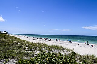
Nokomis is an unincorporated town in Sarasota County and a census-designated place (CDP) along the Gulf Coast of Florida, United States, located south of Osprey and just north of Venice. The town has access to the coast through Nokomis Public Beach and Casey Key. The town's population was 3,217 at the 2020 census, up from 3,167 at the 2010 census. It is part of the North Port–Bradenton–Sarasota, Florida Metropolitan Statistical Area.
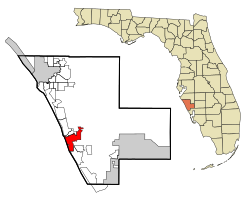
North Port is a city located in Sarasota County, Florida, United States. The population was 74,793 at the 2020 US Census,, up from 57,357 at the 2010 US Census. It is a principal city in the North Port–Bradenton–Sarasota, Florida Metropolitan Statistical Area.
Sarasota is a city in and the county seat of Sarasota County, Florida, United States. It is located in Southwest Florida, the southern end of the Greater Tampa Bay Area, and north of Fort Myers and Punta Gorda. Its official limits include Sarasota Bay and several barrier islands between the bay and the Gulf of Mexico. Sarasota is a principal city of the North Port-Bradenton-Sarasota, FL Metropolitan Statistical Area. According to the 2020 U.S. census, Sarasota had a population of 54,842, up from 51,917 at the 2010 census.
Siesta Key is a barrier island off the southwest coast of the U.S. state of Florida, located between Roberts Bay and the Gulf of Mexico. A portion of it lies within the city boundary of Sarasota, but the majority of the key is a census-designated place (CDP) in Sarasota County. Siesta Key is part of the North Port–Bradenton–Sarasota, Florida Metropolitan Statistical Area.
South Venice is a census-designated place (CDP) in Sarasota County, Florida, United States. The population was 15,619 at the 2020 census, up from 13,949 at the 2010 census. It is part of the North Port–Bradenton–Sarasota, Florida Metropolitan Statistical Area.
Venice Gardens is a census-designated place (CDP) in Sarasota County, Florida, United States. The population was 3,402 at the 2020 census, down from 7,104 at the 2010 census. It is part of the North Port–Bradenton–Sarasota, Florida Metropolitan Statistical Area.
New Smyrna Beach is a city in Volusia County, Florida, United States, located on the central east coast of the state, with the Atlantic Ocean to the east. The downtown section of the city is located on the west side of the Indian River and the Indian River Lagoon system. The Coronado Beach Bridge crosses the Intracoastal Waterway just south of Ponce de Leon Inlet, connecting the mainland with the beach on the coastal barrier island. Its population is 30,142 in 2020 by the United States Census Bureau.
The Sarasota metropolitan area is a metropolitan area located in Southwest Florida. The metropolitan area is defined by the Office of Management and Budget (OMB) as the North Port–Bradenton–Sarasota Metropolitan Statistical Area, a metropolitan statistical area (MSA) consisting of Manatee County and Sarasota County. The principal cities listed by the OMB for the MSA are North Port, Bradenton, Sarasota, Lakewood Ranch, and Venice. At the 2020 census, the MSA had a population of 833,716. The Census Bureau estimates that its population was 891,411 in 2022.
Lakewood Ranch is a planned community and census-designated place (CDP) in southeastern Manatee County and northeastern Sarasota County, Florida, United States, consisting of approximately 31,000 acres (13,000 ha). It is part of the North Port-Bradenton-Sarasota, Florida Metropolitan Statistical Area. According to the 2020 census, the CDP had a population of 34,877.