Hennepin County is a county in the U.S. state of Minnesota. Its county seat is Minneapolis, the state's most populous city. The county is named in honor of the 17th-century explorer Father Louis Hennepin. The county extends from Minneapolis to the suburbs and outlying cities in the western part of the county. The county's natural areas are covered with extensive woods, hills, and lakes.

Louis Hennepin, O.F.M. was a Belgian Catholic priest and missionary of the Franciscan Recollet order and an explorer of the interior of North America.

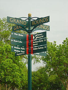
The Grand Rounds National Scenic Byway is a linked series of park areas in Minneapolis, Minnesota, United States, that takes a roughly circular path through the city. The Minneapolis Park and Recreation Board developed the system over many years. The corridors include roads for automobile traffic plus separate paths for pedestrians and bicycles, and extend slightly into neighboring cities. About 50 miles (80 km) of roadway and paths are in the system, and much of it was built in the 1930s as part of Civilian Conservation Corps projects.
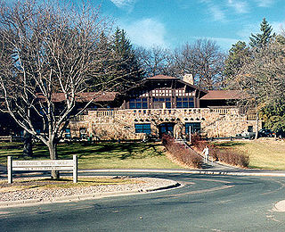
Theodore Wirth Park is the regional park managed by the Minneapolis Park and Recreation Board. The park land is shared by Minneapolis and the neighboring suburb of Golden Valley. Formally named Theodore Wirth Regional Park, it includes two golf courses, Wirth Lake, Birch Pond, cross-country ski trails, mountain biking trails, snow tubing hills, and other amenities. It forms a significant portion of the Grand Rounds Scenic Byway, linking the Chain of Lakes area with the Victory Memorial Parkway.

Cedar Lake Trail is a 4.3-mile (6.9 km), shared-use path in the U.S. state of Minnesota, from downtown Minneapolis to the neighboring suburb of St. Louis Park. The trail begins at its eastern trailhead in downtown Minneapolis (44°59′11″N93°16′01″W) and continues west to Minnesota State Highway 100 in St. Louis Park (44°57′43″N93°20′36″W). At the trail's west end, a paved path continues for another 4.2 miles (6.8 km) through St. Louis Park to Hopkins under the former name of Hutchinson Spur Trail, but known as North Cedar Lake Regional Trail since 2009. In 2019, large portions of the Cedar Lake Trail were closed due to construction of the Southwest LRT extension with expected reopening in 2021 or 2022.

The Midtown Greenway is a 5.7-mile (9.2 km) rail trail in Minneapolis, Minnesota that follows the path of an abandoned route of the Milwaukee Road railway. It is considered under segregated cycle facilities.
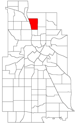
The Audubon Park neighborhood is located in the Northeast community in Minneapolis. Audubon Park is one of ten neighborhoods in Ward 1 of Minneapolis, which is represented on the Minneapolis City Council by Councilmember Elliot Payne. The neighborhood is bounded by Saint Anthony Parkway to the north, NE Stinson Parkway to the east, NE Lowry Avenue to the south, and Central Avenue to the west. Stinson Parkway and St. Anthony Parkway are both part of the Grand Rounds National Scenic Byway. Stinson Parkway is also the city's border with St. Anthony.

Three Rivers Park District is a special park district serving the suburban areas of the Twin Cities including suburban Hennepin, Carver, Dakota, Scott, and Ramsey counties. Three Rivers's mission is "To promote environmental stewardship through recreation and education in a natural resources-based park system." Three Rivers operates twenty parks and ten regional trails, with at least two more regional trails planned. Nearly seven million people visit Three Rivers facilities each year. It has over 27,000 acres (11,000 ha) of parks and trails.

Lind-Bohanon is a northern neighborhood within the Camden community in Minneapolis.
The American Elm cultivar Ulmus americana 'Minneapolis Park', originally called 'Minneapolis Park Board Selection', was a cold-hardy clone selected before 1930 by Theodore Wirth, Superintendent of the Minneapolis Park Department, to replace the 'Moline' elms killed in the 1920s by Minneapolis winters.
Minneapolis is the largest city in the state of Minnesota in the United States, and the county seat of Hennepin County.

Charles Morgridge Loring was an American businessman, miller and publicist. Raised in Maine to be a sea captain, Loring instead became a civic leader in Minneapolis, Minnesota where he was a wealthy flour miller and in Riverside, California where he helped to build the first city hall. He was a popular and generous man who enjoyed many friendships and business associations.

North Mississippi Regional Park is a joint effort of the Minneapolis Park and Recreation Board and the Three Rivers Park District and lies within the larger Mississippi National River and Recreation Area. The park, located near the northern border of Minneapolis, Minnesota, borders the western shore of the Mississippi River. Connected to the Grand Rounds Scenic Byway through biking trails, it ties the Anoka County park system to the parkways of Minneapolis.

Waite Park is a neighborhood in the Northeast community in Minneapolis, Minnesota. Its boundaries are 37th Avenue NE to the north, NE Stinson Boulevard to the East, Saint Anthony Parkway to the south, and NE Central Avenue to the west. It is the furthest northeast neighborhood within Minneapolis. The neighborhood is within Minneapolis's first ward and falls under the jurisdiction of the second precinct of the Minneapolis Police Department.

The Minneapolis Post Office is the central post office for the city of Minneapolis, Minnesota in the United States. Located on the west bank of the Mississippi River, the facility extends west to east from Hennepin Avenue Bridge to the Third Avenue Bridge and north to south from the West River Parkway on the Grand Rounds Scenic Byway to First Street. Its ZIP code is 55401.
Marshall Terrace is a neighborhood in the Northeast community in Minneapolis.
The Minneapolis Park and Recreation Board (MPRB) is an independent park district that owns, maintains, and programs activities in public parks in Minneapolis, Minnesota, United States. It has 500 full-time and 1,300 part-time employees and an $111 million operating and capital budget.

Winchell Trail is a five-mile (8 km) round trip, pedestrian-only trail in Minneapolis, Minnesota, United States, that runs along the west side of the Mississippi River between Franklin Avenue South and East 44th Street. Popular with bird watchers and naturalists, the rustic trail provides Upper Mississippi River gorge access and views. The trail is separate from the adjacent multi-use bicycle path, taking hikers past sandy beaches, an oak savanna restoration project, and the floodplain forest. The trail has multiple access points and the section from East 38th Street to East 44th Street is paved. Described as moderate and for all hiking skill levels, the out-and-back Winchell Trail has total elevation gain of 501 feet (153 m). Portions of the trail can be hiked in near solitude as its age and general destitute make it a widely forgotten place to explore.

Minnehaha Trail is a 1.5-mile (2.4 km) paved, multi-use trail in Minneapolis, Minnesota, United States, that connects Minnehaha Regional Park and Fort Snelling State Park – two of the most popular recreation destinations in the Twin Cities metro area. The trail is considered a segment of a longer, loosely connected bicycle route system along the Mississippi River. Users of Minnehaha Trail traverse under a forest canopy. The trail received local recognition for its natural beauty, but it was criticized for its worn pavement and lack of signage.