
The geography of Croatia is defined by its location—it is described as a part of Central Europe and Southeast Europe, a part of the Balkans and Southern Europe. Croatia's territory covers 56,594 km2 (21,851 sq mi), making it the 127th largest country in the world. Bordered by Bosnia and Herzegovina and Serbia in the east, Slovenia in the west, Hungary in the north and Montenegro and the Adriatic Sea in the south, it lies mostly between latitudes 42° and 47° N and longitudes 13° and 20° E. Croatia's territorial waters encompass 18,981 square kilometres (7,329 sq mi) in a 12 nautical miles wide zone, and its internal waters located within the baseline cover an additional 12,498 square kilometres (4,826 sq mi).
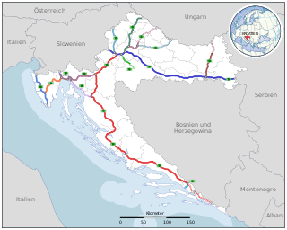
Transport in Croatia relies on several main modes, including transport by car, train, ship and plane. Road transport incorporates a comprehensive network of state, county and local routes augmented by a network of highways for long-distance travelling. Water transport can be divided into sea, based on the ports of Rijeka, Ploče, Split and Zadar, and river transport, based on Sava, Danube and, to a lesser extent, Drava. Croatia has 9 international airports and several airlines, of which the most notable are Croatia Airlines and Trade Air. Rail network is fairly developed but regarding inter-city transport, bus tends to be far more common than the rail.
Slavonia is, with Dalmatia, Croatia proper, and Istria, one of the four historical regions of Croatia. Taking up the east of the country, it roughly corresponds with five Croatian counties: Brod-Posavina, Osijek-Baranja, Požega-Slavonia, Virovitica-Podravina, and Vukovar-Syrmia, although the territory of the counties includes Baranya, and the definition of the western extent of Slavonia as a region varies. The counties cover 12,556 square kilometres or 22.2% of Croatia, inhabited by 806,192—18.8% of Croatia's population. The largest city in the region is Osijek, followed by Slavonski Brod and Vinkovci.
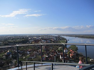
Vukovar is a city in Croatia, in the eastern region of Slavonia. It contains Croatia's largest river port, located at the confluence of the Vuka and the Danube. Vukovar is the seat of Vukovar-Syrmia County and the second largest city in the county after Vinkovci. The city's registered population was 22,616 in the 2021 census, with a total of 23,536 in the municipality.

Vukovar-Srijem County, Vukovar-Sirmium County or Vukovar-Syrmia County, named after the eponymous town of Vukovar and the region of Syrmia, is the easternmost Croatian county. It includes the eastern parts of the region of Slavonia and the western parts of the region of Syrmia, as well as the lower Sava river basin, Posavina and Danube river basin Podunavlje. Due to the overlapping definitions of geographic regions, division on Slavonia and Syrmia approximately divides the county vertically into north-west and south-east half, while division on Posavina and Podunavlje divides it horizontally on north-east and south-west half.

The Sava is a river in Central and Southeast Europe, a right-bank and the longest tributary of the Danube. It flows through Slovenia, Croatia and along its border with Bosnia and Herzegovina, and finally through Serbia, feeding into the Danube in its capital, Belgrade. The Sava forms the main northern limit of the Balkan Peninsula, and the southern edge of the Pannonian Plain.

The Sutla (Croatian) or Sotla (Slovene) is a river flowing through Slovenia and Croatia, mostly forming their border. It is a tributary to the Sava, itself a tributary to the Danube. It is 89 kilometres (55 mi) long and has a watershed area of 584 square kilometres (225 sq mi).

Borovo, also known as Borovo Selo, is a village and a municipality in Vukovar-Syrmia County in eastern Croatia. The settlement is situated on the Danube river on the state border with Serbia and the Municipality of Bač on the other bank. The history of Borovo is closely intertwined with the river which as an recognized international waterway helped in development of Borovo as an important regional industrial center.

Markušica is a village and a municipality in Vukovar-Syrmia County in eastern Croatia. Markušica is located south of the river Vuka and northwest of the town of Vinkovci. Landscape of the Markušica Municipality is marked by the Pannonian Basin plains and agricultural fields of corn, wheat, common sunflower and sugar beet.

Trpinja is a village and an eponymous municipality in the Vukovar-Syrmia County in eastern Croatia. The village is located on the D55 road between Osijek and Vukovar. Landscape of the Trpinja Municipality is marked by the Pannonian Basin plains and agricultural fields of corn, wheat, common sunflower and sugar beet.

The Croatian interlace or Croatian wattle, known as the pleter or troplet in Croatian, is a type of interlace, most characteristic for its three-ribbon pattern. It is one of the most often used patterns of pre-romanesque Croatian art. It is found on and within churches as well as monasteries built in early medieval Kingdom of Croatia between the 9th and beginning of the 12th century. The ornamental strings were sometimes grouped together with animal and herbal figures.
Nijemci is a village and a municipality in the Vukovar-Syrmia County in Croatia.

The Danube is a river that was once a long-standing frontier of the Roman Empire and today connects 10 European countries, running through their territories or being a border. Originating in Germany, the Danube flows southeast for 2,850 km (1,770 mi), passing through or bordering Austria, Slovakia, Hungary, Croatia, Serbia, Romania, Bulgaria, Moldova and Ukraine before draining into the Black Sea. Its drainage basin extends into nine more countries. The largest cities on the river are Vienna, Budapest, Belgrade and Bratislava, all of which are the capitals of their respective countries. The Danube passes through four capital cities, more than any other river in the world. Five more capital cities lie in the Danube's basin: Bucharest, Sofia, Zagreb, Ljubljana and Sarajevo. The fourth-largest city in its basin is Munich, the capital of Bavaria, standing on the Isar River.

Šarengrad is a village in eastern Croatia. It is located along the Danube river and is administratively part of Croatian easternmost town of Ilok. Šarengrad is known for its landscape which is dominated by the river and picturesque houses and church tower next to it. Island of Šarengrad is an 9 km2 river island situated close to the village.
Eastern Slavonia, Baranja and Western Syrmia, commonly abbreviated as Eastern Slavonia, was a short-lived Serb parallel entity in the territory of Croatia along the Danube river.

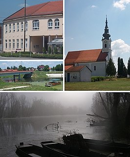
Pačetin is a village in the municipality of Trpinja, Vukovar-Syrmia County in the easternmost part of Croatia. At the time of the 2011 Census the population of the village was 541. Village lies north of the Vuka River and west of the M601 railway. Its major landmark is the Church of St. Nicholas from the 18th century. County road Ž4111 passing through the villages of Pačetin, Bobota and Vera connect all three villages with D2 road and D55 road. Pačetin is 28.6 km southeast of Osijek, the economic and cultural centre of Slavonia and 17.2 km from the Osijek Airport. County seat Vukovar is 17.3 km east of Pačetin.

Bršadin is a village in the Trpinja Municipality in Croatian easternmost Vukovar-Syrmia County. Bršadin is located north of the Vuka river and west of the town of Vukovar on the main road to Vinkovci.
Mile Dedaković is a retired Croatian Army colonel. Also known by his nom de guerreJastreb ("Hawk"), Dedaković is best known for commanding the 204th Vukovar Brigade and the city of Vukovar's defenses during the 1991 Battle of Vukovar in the early stages of the Croatian War of Independence.

Jean-Michel Nicollier was a French volunteer and Croatian soldier in the Croatian War of Independence who was killed in the Vukovar massacre.

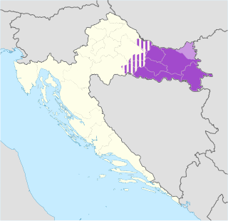
The border between Croatia and Serbia in the area of the Danube is disputed. While Serbia holds the opinion that the thalweg of the Danube valley and the centerline of the river represents the international border between the two countries, Croatia disagrees and claims that the international border lies along the boundaries of the cadastral municipalities located along the river—departing from the course at several points along a 140-kilometre (87 mi) section. The cadastre-based boundary reflects the course of the Danube which existed in the 19th century, before meandering and hydrotechnical engineering works altered its course. The area size of the territory in dispute is reported variously, up to 140 square kilometres.

