Wadsworth, Ohio

Last updated

Wadsworth, Ohio
St. Mark in Wadsworth, OH taken by Rickofwood.jpg
OHMap-doton-Wadsworth.png
Location of Wadsworth, Ohio
Map of Medina County Ohio Highlighting Wadsworth City.png
Location of Wadsworth in Medina County
Coordinates: 41°01′10″N81°44′35″W / 41.01944°N 81.74306°W / 41.01944; -81.74306
Country United States
State Ohio
County Medina
FoundedMarch 1, 1814;209 years ago (1814-03-01)
IncorporatedJanuary 1, 1876;148 years ago (1876-01-01) (village)
IncorporatedJanuary 1, 1931;93 years ago (1931-01-01) (city)
Government
  Type Mayor-Council
Area
[1]
  Total11.34 sq mi (29.38 km2)
  Land11.34 sq mi (29.36 km2)
  Water0.01 sq mi (0.02 km2)
Elevation
[2]
1,165 ft (355 m)
Population
 (2020)
  Total24,007
  Density2,117.95/sq mi (817.72/km2)
Time zone UTC-5 (Eastern (EST))
  Summer (DST) UTC-4 (EDT)
ZIP codes
44281-44282
Area code(s) 234, 330
FIPS code 39-80304 [3]
GNIS feature ID2397162 [2]
Website https://www.wadsworthcity.com/

Wadsworth is a city in Medina County, Ohio, United States. Founded on March 1, 1814, the city was named after General Elijah Wadsworth, a Revolutionary War hero and War of 1812 officer who owned the largest share of the lands that became Medina County. [4] A suburb of Akron, the population was 24,007 at the 2020 census.

Contents

History

A post office called Wadsworth has been in operation since 1823. [5]

Geography

According to the United States Census Bureau, the city has a total area of 10.62 square miles (27.51 km2), all land. [6] It is located just a few miles south of the Saint Lawrence River Divide. Wadsworth is located approximately 11.6 miles (18.7 km) southwest of Akron and 32.8 miles (52.8 km) south of Cleveland.

Demographics

Historical population
CensusPop.Note
1880 1,219
1890 1,57629.3%
1900 1,76411.9%
1910 3,07374.2%
1920 4,74254.3%
1930 5,92024.8%
1940 6,4959.7%
1950 7,96622.6%
1960 10,63533.5%
1970 13,14223.6%
1980 15,18715.6%
1990 15,7183.5%
2000 18,43717.3%
2010 21,56717.0%
2020 24,00711.3%
Sources: [7] [8] [3]

As of 2000, the median income for a household in the city was $48,605, and the median income for a family was $58,850. Males had a median income of $41,626 versus $25,805 for females. The per capita income for the city was $22,859. 5.4% of the population and 4.2% of families were below the poverty line, including 5.7% of those under the age of 18 and 5.6% of those 65 and older.

2010 census

As of the census [9] of 2010, there were 21,567 people, 8,609 households, and 5,803 families residing in the city. The population density was 2,030.8 inhabitants per square mile (784.1/km2). There were 9,320 housing units at an average density of 877.6 per square mile (338.8/km2). The racial makeup of the city was 96.9% White, 0.8% African American, 0.2% Native American, 0.7% Asian, 0.2% from other races, and 1.1% from two or more races. Hispanic or Latino people of any race were 1.2% of the population.

There were 8,609 households, of which 33.8% had children under the age of 18 living with them, 54.2% were married couples living together, 9.6% had a female householder with no husband present, 3.6% had a male householder with no wife present, and 32.6% were non-families. 28.0% of all households were made up of individuals, and 12.6% had someone living alone who was 65 years of age or older. The average household size was 2.48 and the average family size was 3.05.

The median age in the city was 38.7 years. 25.6% of residents were under the age of 18; 7.3% were between the ages of 18 and 24; 26.2% were from 25 to 44; 25% were from 45 to 64; and 15.8% were 65 years of age or older. The gender makeup of the city was 48.1% male and 51.9% female.

Of the city's population over the age of 25, 31.2% held a bachelor's degree or higher. [10]

Education

The Wadsworth City School District is the single largest employer in the city. The district has benefited from the support of the community, which passed six of the last seven levies put before the voters. In addition, the district voters supported the recent Medina County Sales Tax (the first in Ohio), at a rate of 74% for the levy. According to school district Treasurer Doug Beeman, revenues for the fiscal year ending June 30, 2007, exceeded expenditures as the school system continues to manage the resources provided by the community.

Wadsworth High School and Wadsworth Middle School are members of the Ohio High School Athletic Association. The high school and middle school mascot is the grizzly bear.

Wadsworth City School district operates eight schools. There are five elementary schools (kindergarten through grade 4), one intermediate school (grades 5 and 6), one middle school (grades 7 and 8) and one high school (grades 9 through 12). As of 2012, Wadsworth City Schools had completed a construction project in which a $115 million high school was built, along with three new elementary buildings. The total enrollment is approximately 4,849 students.

Other schools in the city of Wadsworth include Sacred Heart School, a Roman Catholic parochial school serving Kindergarten through 8th grade. [11]

Media

Wadsworth is served by a daily newspaper, The Medina County Gazette [12] which is published every day of the week except Sundays. In addition, the Akron Beacon Journal and the Cleveland Plain Dealer occasionally cover the city and Medina County. Wadsworth is served by numerous television and radio stations from both the Greater Cleveland, Greater Akron and Greater Canton areas.

Transportation

Wadsworth is served by the Wadsworth Municipal Airport, which is located 2 miles (3.22 km) southwest of the city. Skypark Airport is located 2 miles west of the city.I-76 traverses the city. State routes include OH-57, OH-94 and OH-261.

Blue Tip Festival

The Blue Tip Festival is a five-day celebration of the Wadsworth community. It starts with a parade and the lighting of a 20-foot-high blue-tip match, which lights downtown Wadsworth during the festival's duration. The festival offers amusement rides, festival foods, midway games, contests, a local merchant's tent, and other entertainment. Additional events, such as the Wadsworth Running Club's "Matchstick 4 Mile" foot race and the "Blue Tip Idol" singing contest, challenge area athletes and performers. Special events have included passenger train rides on the Blue Tip Express, Community Challenges between local organizations, big top circus performances, paint ball shooting ranges, pony rides, bingo tents, and assorted musical performances. 2017 marked the 45th annual Blue Tip Festival.

The festival is named after the historic strike-anywhere blue tip matches which were once manufactured in Wadsworth. While match manufacturing left Wadsworth in the 1980s, the Blue Tip Festival uses the name and giant match to affirm the community's past and celebrate the modern American city. The festival is now run by a non-profit organization, staffed entirely by volunteers, referred to as the Blue Tip Festival Committee. Revenues from the festival are donated to Wadsworth area non-profit groups. [13]

Notable people

See also

Related Research Articles

<span class="mw-page-title-main">Summit County, Ohio</span> County in Ohio, United States

Summit County is an urban county in the U.S. state of Ohio. As of the 2020 census, the population was 540,428, making it the fourth-most populous county in Ohio. Its county seat and largest city is Akron. The county was formed on March 3, 1840, from portions of Medina, Portage and Stark Counties. It was named Summit County because the highest elevation on the Ohio and Erie Canal is located in the county.

<span class="mw-page-title-main">Medina County, Ohio</span> County in the United States

Medina County is a county in the U.S. state of Ohio. As of the 2020 census, the population was 182,470. Its county seat is Medina, and its largest city is Brunswick.

<span class="mw-page-title-main">East Palestine, Ohio</span> Village in Ohio, United States

East Palestine is a village in northeastern Columbiana County, Ohio, United States. The population was 4,761 at the 2020 census. Located on the state's border with Pennsylvania, East Palestine is about 20 miles (32 km) south of Youngstown and 40 miles (64 km) northwest of Pittsburgh. It is part of the Salem micropolitan area.

<span class="mw-page-title-main">Ada, Ohio</span> Village in Ohio, United States

Ada is a village in Hardin County, Ohio, United States, located about 69 miles (111 km) southwest of Toledo. The population was 5,334 at the 2020 census. It is the home of Ohio Northern University.

<span class="mw-page-title-main">North Ridgeville, Ohio</span> City in Ohio, United States

North Ridgeville is a city located along the eastern border of Lorain County, Ohio, United States. The city's population was 35,280 as of the 2020 census. A part of the Cleveland metropolitan area, North Ridgeville is the fastest-growing city in northern Ohio. It has been ranked the 13th safest city in the United States and the safest in Ohio.

<span class="mw-page-title-main">Canfield, Ohio</span> City in Ohio, United States

Canfield is a city in central Mahoning County, Ohio, United States. The population was 7,699 as of the 2020 census. A suburb about 8 miles (13 km) southwest of Youngstown, the city lies at the intersection of U.S. Routes 62 and 224 and is part of the Youngstown–Warren metropolitan area. In 2005, Canfield was rated the 82nd best place to live in the United States by Money magazine.

<span class="mw-page-title-main">Brunswick, Ohio</span> City in Ohio, United States

Brunswick is the largest city in Medina County, Ohio, United States, approximately 20 miles (32 km) southwest of Cleveland. The population was 35,426 at the 2020 census. It is part of the Cleveland metropolitan area.

<span class="mw-page-title-main">Lodi, Ohio</span> Village in Ohio, United States

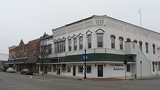
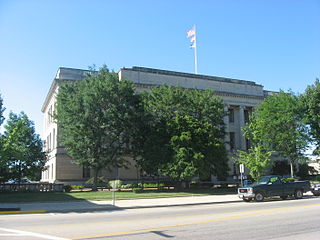
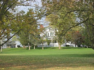
Lodi is a village in Harrisville Township, Medina County, Ohio, United States. It is located southwest of the City of Medina along U.S. Route 42. As of the 2020 census, the population was 2,746.

<span class="mw-page-title-main">Medina, Ohio</span> City in Medina County, Ohio

Medina is a city in and the county seat of Medina County, Ohio, United States. The population was 26,094 at the 2020 census. It lies about 33 miles (53 km) south of Cleveland and 23 miles (37 km) west of Akron within the Cleveland metropolitan area.

<span class="mw-page-title-main">Spencer, Ohio</span> Village in Ohio, United States

Spencer is a village in Spencer Township located in Medina County, Ohio, United States. The population was 684 at the 2020 census.

<span class="mw-page-title-main">West Carrollton, Ohio</span> City in Ohio, United States

West Carrollton is a city in Montgomery County, Ohio, United States. A suburb of Dayton, its population was 13,129 at the 2020 census. It is part of the Dayton Metropolitan Statistical Area. The Great Miami River runs through the town and forms most of its northern border.

<span class="mw-page-title-main">Mantua, Ohio</span> Village in Ohio, United States

Mantua is a village in northern Portage County, Ohio, United States, along the Cuyahoga River. The population was 1,001 at the time of the 2020 census. It is part of the Akron metropolitan area. It was formed from portions of Mantua Township in the Connecticut Western Reserve.

<span class="mw-page-title-main">Streetsboro, Ohio</span> City in Ohio, United States

Streetsboro is a city in western Portage County, Ohio, United States. The population was 17,260 at the 2020 census. It is part of the Akron metropolitan area. The city was formed from the former Streetsboro Township of the Connecticut Western Reserve.

<span class="mw-page-title-main">Eaton, Ohio</span> City in Ohio, United States

Eaton is a city in, and the county seat of Preble County, Ohio, United States, approximately 24 mi (38 km) west of Dayton. The population was 8,375 at the 2020 census, down 0.4% from the population of 8,407 at the 2010 census.

<span class="mw-page-title-main">Girard, Ohio</span> City in Ohio, United States

Girard is a city in southern Trumbull County, Ohio, United States, along the Mahoning River. The population was 9,603 at the 2020 census. Located directly north of Youngstown, it is a suburb of the Youngstown–Warren metropolitan area.

<span class="mw-page-title-main">Dover, Ohio</span> City in Ohio, United States

Dover is a city in Tuscarawas County, Ohio, United States, along the Tuscarawas River. The population was 13,112 at the 2020 census. It is a principal city of the New Philadelphia–Dover micropolitan area, approximately 68 miles (109 km) south of Cleveland and borders the city of New Philadelphia.

<span class="mw-page-title-main">Monroe, Ohio</span> City in Ohio, United States

Monroe is a city in east central Butler and west central Warren counties in the southwestern part of the U.S. state of Ohio. The population was 15,412 at the 2020 census. Monroe is a part of the Cincinnati metropolitan area.

<span class="mw-page-title-main">Tallmadge, Ohio</span> City in Ohio, United States

Tallmadge is a city in eastern Summit County, Ohio, United States, with a small district in neighboring Portage County. It is a suburb of Akron and part of the Akron metropolitan area. The population was 18,394 at the 2020 census. Tallmadge was founded in 1807 and is the second-oldest city in Summit County, following Hudson, which was founded in 1799.

<span class="mw-page-title-main">Norton, Ohio</span> City in Ohio, United States

Norton is a city in southwestern Summit County, Ohio, United States, with a 4.4-acre (1.8 ha) district extending into Wayne County. The population was 11,673 at the 2020 census. It is part of the Akron metropolitan area.

<span class="mw-page-title-main">Twinsburg, Ohio</span> City in Ohio, United States

Twinsburg is a suburban city in Summit County, Ohio, United States, located midway between Akron and Cleveland. The population was 19,248 as of the 2020 census. It is part of the Akron metropolitan area.

References

  1. "ArcGIS REST Services Directory". United States Census Bureau. Retrieved September 20, 2022.
  2. 1 2 U.S. Geological Survey Geographic Names Information System: Wadsworth, Ohio
  3. 1 2 "U.S. Census website". United States Census Bureau . Retrieved January 31, 2008.
  4. Schapiro, Elanor Iler (1964). Wadsworth Heritage. Wadsworth News-Banner.
  5. Overman, William Daniel (1958). Ohio Town Names. Akron, OH: Atlantic Press. p. 138.
  6. "US Gazetteer files 2010". United States Census Bureau . Retrieved January 6, 2013.
  7. "Number of Inhabitants: Ohio" (PDF). 18th Census of the United States. U.S. Census Bureau. 1960. Retrieved May 17, 2020.
  8. "Ohio: Population and Housing Unit Counts" (PDF). U.S. Census Bureau. Retrieved November 22, 2013.
  9. "U.S. Census website". United States Census Bureau . Retrieved January 6, 2013.
  10. "Wadsworth (City) QuickFacts from the US Census Bureau". Archived from the original on January 21, 2016. Retrieved January 8, 2014.
  11. "Home". Sacred Heart of Jesus Catholic School.
  12. "Medina County news | Medina Gazette". medina-gazette.com.
  13. "Blue Tip Festival History" . Retrieved October 29, 2008.
  14. "Scott Fletcher". Baseball-Reference.com. Retrieved January 31, 2023.
  15. "Astronaut Bio: Michael J. Foreman (07/2013)". www.jsc.nasa.gov. February 11, 2015. Retrieved April 21, 2018.
  16. "Hess wins ARCA 500K". The News-Press . Fort Myers, FL. March 19, 1989. p. 9. Retrieved December 22, 2017.
  17. "Jim Renacci". www.ballotpedia.org. Retrieved April 15, 2019.
  18. "Bishop Sankey". Pro-Football-Reference.com. Retrieved January 31, 2023.
  19. "Andy Sonnanstine". Baseball-Reference.com. Retrieved January 31, 2023.