Akron metropolitan area

Last updated

Greater Akron
Akron, OH Metropolitan Statistical Area
AkronPanorama.jpg
View of the Akron skyline from the west looking east
Akron metropolitan area
Interactive Map of Akron, OH MSA
Country United States
State Ohio
Largest city Akron
other cities
Population
 (2020)
   MSA
702,219 (72nd)
   CSA
3,633,962 (17th)
 MSA/CSA = 2020
Time zone UTC−5 (EST)
  Summer (DST) UTC−4 (EDT)
Area codes 330, 234

The Akron, OH Metropolitan Statistical Area, sometimes referred to as Greater Akron, is defined by the United States Office of Management and Budget as an area consisting of two counties, Summit and Portage, in Northeast Ohio and anchored by the city of Akron. As of the 2020 census, the MSA had a population of 702,219. The Akron MSA is also part of the larger Cleveland–Akron–Canton, OH Combined Statistical Area, which has a population of 3,633,962 people as of the 2020 census, the largest metropolitan area in Ohio.

Contents

Historically, Greater Akron was known as the center of the United States' tire and rubber industry throughout the 20th century, and today one major tire company (Goodyear Tire and Rubber) still is based there. More recently, the area has become a center of polymer science research and manufacturing for the country, [1] and is home to five Fortune 1000 corporations.

Communities

Places with more than 100,000 inhabitants

Places with 25,000 to 100,000 inhabitants

Cuyahoga Falls is the second largest city in Greater Akron. Downtown Cuyahoga Falls.jpg
Cuyahoga Falls is the second largest city in Greater Akron.

Places with 10,000 to 25,000 inhabitants

Places with 5,000 to 10,000 inhabitants

Places with 1,000 to 5,000 inhabitants

Places with less than 1,000 inhabitants

Sugar Bush Knolls has the highest median household income of any incorporated place in Greater Akron. Lake Martin Drive, Sugar Bush Knolls, Ohio.jpg
Sugar Bush Knolls has the highest median household income of any incorporated place in Greater Akron.

Unincorporated places

Demographics

Historical population
CensusPop.Note
1900 100,961
1910 138,56037.2%
1920 322,434132.7%
1930 386,81320.0%
1940 386,065−0.2%
1950 474,01622.8%
1960 605,36727.7%
1970 679,23912.2%
1980 660,328−2.8%
1990 657,575−0.4%
2000 694,9605.7%
2010 703,2001.2%
2020 702,219−0.1%
[2] [3]

As of the census [4] of 2010, there were 703,200 people, 279,518 households, and 181,540 families residing within the MSA. The racial makeup of the MSA was 84.8% White, 11.9% African American, 0.20% Native American, 1.8% Asian, 0% Pacific Islander, 0.26% from other races, and 1.34% from two or more races. Hispanic or Latino of any race were 1.2% of the population. 3.4% of the population were reported as foreign born, and 5.4% reported speaking a language other than English as the primary language in the home. In the MSA the population was spread out, with 18.7% the age of 14 or under, 14.4% from 15 to 24, 25.7% from 25 to 44, 27.6% from 45 to 64, and 13.5% who were 65 years of age or older. For every 100 females, there were 94.1 males.

The median family income in 2007 dollars in the MSA was $61,537, and the median household income in the MSA was $47,336. Males had a median income of $38,776 versus $26,532 for females. The per capita income for the MSA was $36,564 in 2007 dollars.

County 2020 Census2010 CensusChangeAreaDensity
Summit County 540,428541,781−0.25%419.38 sq mi (1,086.2 km2)
Portage County 161,791161,419+0.23%504 sq mi (1,310 km2)

Economy

As of 2006, the Akron metropolitan area serves as the corporate headquarters of 5 Fortune 1000 firms (shown with 2006 rankings below):

Other large employers include:

Transportation

Airports

The Akron metropolitan area is served by the following international, regional and county airports:

Highways

Public transit

In Summit County, public transportation is available through the METRO Regional Transit Authority [9] system, which has a fleet of over two hundred buses and trolleys and operates local routes as well as running commuter buses into downtown Cleveland. The Portage Area Regional Transportation Authority (PARTA) [10] operates throughout Portage County and also runs an express route connecting the University of Akron with Kent State University.

Education

The Kent Student Center at Kent State University. KSC2.jpg
The Kent Student Center at Kent State University.

Media

Akron Beacon Journal headquarters AkronBeaconTower.jpg
Akron Beacon Journal headquarters

Print

The Akron area is served in print by the daily Akron Beacon Journal, formerly the flagship newspaper of the Knight Newspapers chain; the weekly "The Akron Reporter"; and the weekly West Side Leader newspapers and the monthly magazine Akron Life. The Buchtelite newspaper is published by the University of Akron. [15]

TV

Akron is part of the Cleveland-Akron-Canton TV market, the 18th largest market in the U.S. [16] Within the market, WEAO (PBS), WVPX (ION), and WBNX-TV (independent) are licensed to Akron. However, while WEAO serves the city of Akron specifically, WBNX and WVPX identify themselves as Akron/Cleveland, serving the entire market. Akron has no native news broadcast, having lost its only news station when the former WAKC became WVPX in 1996. WVPX and Cleveland's WKYC later provided a joint news program, which was cancelled in 2005. [17] [18]

Radio

While part of a combined TV market with Cleveland, the Akron area is its own radio market, and served by WZIP 88.1 (Top 40 – University of Akron), WSTB 88.9 (alternative), WKSU 89.7 (public radio), WAPS 91.3 (album adult alternative), WKJA 91.9 (religious), WQMX 94.9 (country), WONE 97.5 (classic rock), WKDD 98.1 (contemporary hits), WNIR-FM 100.1 (news/talk), WHLO 640 (news/talk), WCUE 1150 (religious), and WAKR 1590/93.5 (soft adult contemporary/full service).

Culture

Theaters and concert venues

The Blossom Music Center in Cuyahoga Falls. Blossom Music Center.jpg
The Blossom Music Center in Cuyahoga Falls.

Museums and historic landmarks

The entrance to the Stan Hywet Hall and Gardens, Akron. Stan Hywett Front.JPG
The entrance to the Stan Hywet Hall and Gardens, Akron.

Parks and recreation

National parks

Cuyahoga Valley National Park

Cuyahoga Valley National Park [45] is a national park located in Summit County and lies between the major Ohio cities of Cleveland and Akron. It is the only national park located in Ohio and consists of over 33,000 acres. Waterfalls, rolling hills, caves, winding river scenery attract many park visitors. Over 125 miles of trails traverse the steep narrow ravines, rolling floodplain, and lush farmland throughout the park. The park offers an array of preserved and restored displays of 19th (see Hale Farm & Village) and early 20th century sustainable farming and pastoral, rural living, while catering to contemporary interests with art exhibits, outdoor concerts, and scenic excursion and special event railroad tours on the Cuyahoga Valley Scenic Railroad. [46]

County-wide park districts

Lock 3 Park amphitheater in downtown Akron. LockThreePark 7-4-09.jpg
Lock 3 Park amphitheater in downtown Akron.

Summit Metro Parks

The Summit Metro Parks is a park district that manages over 11,000 acres (4,500 ha) in Summit County, including 14 developed parks, six conservation areas and more than 125 miles (201 km) of trails including the 33.5-mile (53.9 km) Hike and Bike Trail which follows the course of the old Akron, Bedford and Cleveland Railroad. [47] The Freedom Trail is currently under construction, with phases one and two already complete. Phases one and two pass through Tallmadge, Munroe Falls, and Akron, and connect with the western end of the Portage Hike and Bike Trail in Kent. Phase three will connect the Freedom Trail to the Towpath Trail in downtown Akron. [48]

The Ohio and Erie Canal Towpath Trail

The Ohio and Erie Canal Towpath Trail [49] in Summit County follows the course of the former Ohio and Erie Canal. When the trail is fully complete, it will stretch about 100 miles from Downtown Cleveland in Cuyahoga County, though the Cuyahoga Valley National Park and Summit County, Stark County and end in New Philadelphia in Tuscarawas County. In 2011, Summit County became the first of the counties to complete their section of the Towpath Trail stretching 33.4 miles from the Portage Lakes in the southern portion of the county, through the suburbs and downtown Akron, and finally through the Cuyahoga Valley National Park.

Portage Park District

The Portage Park District is a county park district in Portage County that manages 2,470 acres (1,000 ha) of parkland and 14 miles (23 km) of hiking trails. [50] Notable trails include the Headwater Trail which follows the former Cleveland and Mahoning Valley Railroad line and connects Mantua and Garrettsville. The Portage Hike and Bike Trail has several phases completed in and around Kent and Ravenna, with direct connections to the Freedom and Bike and Hike Trails in Summit County. [51]

State parks and nature reserves

Nelson Kennedy Ledges State Park

Nelson Kennedy Ledges State Park [52] is a 167-acre state park located near Garrettsville in Portage County. The spectacular rock formations at Nelson-Kennedy Ledges have become trademarks of the park. These rock formations are among the few outcrops in northern Ohio still exposed to view and offer hiking trails ranging from easy to difficult. Activities located in the park include hiking and picnicking.

Portage Lakes State Park

Portage Lakes State Park [53] is a 2,475 acre state park located in Akron around the Portage Lakes. There are approximately 2034 acres of water and 8 lakes within the park that can be used for boating, fishing, and swimming and an additional 411 acres of land that can be used for camping, hunting, and picnicking.

Tinker's Creek State Park

Tinkers Creek State Park [54] is a 370-acre state park located in Streetsboro in Portage County. Park activities include fishing on a 15-acre spring-fed lake, picnicking, hiking, and cross country skiing and ice fishing during winter.

West Branch State Park

West Branch State Park [55] is an 8,002 acre state park located near Ravenna in Portage County. The large 2,650-acre lake can be used for boating, fishing, and swimming and contains numerous boat launches. The 5,379-acres of meadows and woodlots can be used for numerous activities such as for camping, hiking, hunting and horseback riding. The park maintains 14 miles of hiking trails, 12 miles of mountain biking trails, and 20 miles of bridle trails.

Wingfoot Lake State Park

Wingfoot Lake State Park [56] is a 690-acre state park located in Mogadore in Portage County around Wingfoot Lake. The park was built in the 1960s by the Goodyear Tire and Rubber Company for their employees and corporate retreats. In 2009, the park was bought by the Ohio Department of Natural Resources, Division of Wildlife. Facilities include enclosed and open pavilion shelters (some with fireplaces), playgrounds, badminton courts, horseshoe pits, bocce ball courts, an 18-hole mini-golf course, and an 18-hole disc golf course. Boating and fishing is also permitted on the 444 acre Wingfoot Lake.

Public nature reserves

  • Aurora Sanctuary State Nature Preserve – a 164-acre nature preserve located in Aurora.
  • Eagle Creek State Nature Preserve – a 472-acre nature preserve located in Garrettsville.
  • Herrick Fen – a 127-acre nature preserve located near Streetsboro.
  • Tom S. Cooperrider-Kent Bog State Nature Preserve – a 42-acre nature preserve located in Kent.
  • Marsh Wetlands – a 152-acre nature preserve located near Mantua.
  • Novak (Blanche Katherine) Sanctuary – a 152-acre nature preserve located in Aurora.
  • Portage Lakes Wetland State Nature Preserve – a 6-acre nature preserve located in Akron.
  • Tinker's Creek State Nature Preserve – a 786-acre nature preserve located in Aurora.
  • Triangle Lake Bog State Nature Preserve – a 61-acre nature reserve located in Rootstown.
  • Tummonds State Nature Preserve – an 86-acre nature reserve located near Mantua.

See also

Related Research Articles

<span class="mw-page-title-main">Summit County, Ohio</span> County in Ohio, United States

Summit County is an urban county in the U.S. state of Ohio. As of the 2020 census, the population was 540,428, making it the fourth-most populous county in Ohio. Its county seat and largest city is Akron. The county was formed on March 3, 1840, from portions of Medina, Portage and Stark Counties. It was named Summit County because the highest elevation on the Ohio and Erie Canal is located in the county.

<span class="mw-page-title-main">Portage County, Ohio</span> County in Ohio, United States

Portage County is a county in the U.S. state of Ohio. As of the 2020 census, the population was 161,791. Located in Northeast Ohio, Portage County is part of the Akron Metropolitan Statistical Area, which is also included in the Cleveland–Akron–Canton Combined Statistical Area. Its county seat is Ravenna and its largest city is Kent. The county, named for the portage between the Cuyahoga and Tuscarawas rivers, was created in 1807 and formally organized in 1808. In addition to the cities of Kent and Ravenna, Portage County also includes the cities of Aurora and Streetsboro, along with five villages, 18 civil townships, and several unincorporated places within those townships. Additionally, the county includes parts of the city of Tallmadge, and part of the village of Mogadore, both of which are mostly in neighboring Summit County.

<span class="mw-page-title-main">Akron, Ohio</span> City in Ohio, United States

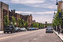
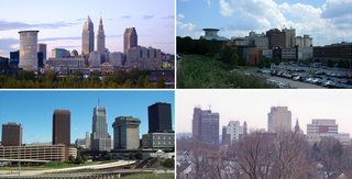
Akron is a city in and the county seat of Summit County, Ohio, United States. At the 2020 census, the city proper had a total population of 190,469, making it the fifth-most populous city in Ohio and 136th-most populous city in the United States. The Akron metropolitan area, covering Summit and Portage counties, had a population of 702,219. It is located on the western edge of the Glaciated Allegheny Plateau in Northeast Ohio about 40 miles (64 km) south of downtown Cleveland.

<span class="mw-page-title-main">Cuyahoga Falls, Ohio</span> City in Ohio, United States

Cuyahoga Falls is a city in Summit County, Ohio, United States. As of the 2020 census, the city population was 51,114. The second-largest city in Summit County, it is located directly north of Akron and is a suburb of the Akron metropolitan area. The city was founded in 1812 by William Wetmore and was originally named Manchester, but renamed for the Cuyahoga River and the series of waterfalls that run along the southern boundary of the city.

<span class="mw-page-title-main">Stow, Ohio</span> City in Ohio, United States

Stow is a city in Summit County, Ohio, United States. The population was 34,483 at the 2020 census. It is a suburban community within the Akron metropolitan area.

William Wetmore founded Cuyahoga Falls, Ohio in 1812.

<span class="mw-page-title-main">Greater Cleveland</span> Metropolitan Statistical Area in Ohio, United States

The Cleveland metropolitan area, or Greater Cleveland as it is more commonly known, is the metropolitan area surrounding the city of Cleveland in Northeast Ohio, United States. According to the 2020 census results, the six-county Cleveland, OH Metropolitan Statistical Area (MSA) consists of Cuyahoga County, Ashtabula County, Geauga County, Lake County, Lorain County, and Medina County, and has a population of 2,185,825, making it the 33rd-most populous metropolitan area in the United States and the third largest metropolitan area in Ohio. The metro area is also part of the larger Cleveland–Akron–Canton Combined Statistical Area with a population of over 3.7 million people, the most populous statistical area in Ohio and the 17th most populous in the United States.

<span class="mw-page-title-main">Northeast Ohio</span> Place in Ohio, United States

The region Northeast Ohio, in the US state of Ohio, in its most expansive usage contains six metropolitan statistical areas: Cleveland–Elyria, Akron, Canton–Massillon, Youngstown–Warren, Mansfield, and Weirton–Steubenville along with eight micropolitan statistical areas. Most of the region is considered either part of the Cleveland–Akron–Canton, OH Combined Statistical Area and media market or the Youngstown–Warren, OH–PA Combined Statistical Area and media market. In all, the region is home to: 4,502,460 residents. It is also a part of the Great Lakes megalopolis, containing over 54 million people. Northeast Ohio also includes most of the area known historically as the Connecticut Western Reserve.

<span class="mw-page-title-main">Cuyahoga Valley National Park</span> National park in Ohio, United States

Cuyahoga Valley National Park is an American national park that preserves and reclaims the rural landscape along the Cuyahoga River between Akron and Cleveland in Northeast Ohio.

<span class="mw-page-title-main">Bath Township, Summit County, Ohio</span> Township in Ohio, United States

Bath Township is one of the nine townships of Summit County, Ohio, United States. A suburb of Akron, the 2020 census found 10,024 people in the township.

Portage Township was one of the sixteen original townships in Summit County, Ohio. It was located in the middle of Summit County. It included the cities/towns of Akron and Cuyahoga Falls as well as an earlier part of Middlebury. Eventually, the township was absorbed by Akron and Cuyahoga Falls and ceased to exist. When created, it was in area and included Survey Town 2, Range 11 in Western Reserve. The township derived its name from the Portage Path, which extends north to south through the middle of the township.

<span class="mw-page-title-main">Ohio State Route 59</span> State highway in Ohio, US

State Route 59 is an east–west state highway in the U.S. state of Ohio, serving the Akron metropolitan area. The western terminus of State Route 59 is in downtown Akron at a partial interchange with the Interstate 76/Interstate 77 concurrency, and the eastern terminus is at State Route 5, 0.5 miles (0.80 km) east of Ravenna. The route is approximately 23 miles (37 km) long and was certified in 1969 over what had previously been part of SR 5. It serves as a major or as the primary east–west roadway for the cities of Cuyahoga Falls, Kent, Ravenna, and Stow, the village of Silver Lake, and Franklin and Ravenna Townships.

<span class="mw-page-title-main">Ohio and Erie Canal</span> 19th-century manmade water route between Akron and Cleveland, Ohio, USA

The Ohio and Erie Canal was a canal constructed during the 1820s and early 1830s in Ohio. It connected Akron with the Cuyahoga River near its outlet on Lake Erie in Cleveland, and a few years later, with the Ohio River near Portsmouth. It also had connections to other canal systems in Pennsylvania.

Northampton was one of the 16 original townships in Summit County, Ohio. It was in the middle of Summit County, bordering Akron and Cuyahoga Falls. No incorporated areas were formed within the township but Akron and Cuyahoga Falls expanded into Northampton via annexation. In 1986, Northampton Township merged with Cuyahoga Falls, the first time a township and city merged in Ohio. When created it occupied survey Town 3, Range 11 in the Western Reserve and was about 25 square miles (65 km2) in area. Its first settler, Simeon Prior named the township for the Hampshire County, Massachusetts village of Northampton.

<span class="mw-page-title-main">Boston Township, Ohio</span> Township in Ohio, United States

Boston Township is one of the nine townships of Summit County, Ohio, United States, about 15 miles north of Akron and 23 miles south of Cleveland. It is part of the Akron metropolitan area. The 2020 census found 1,401 people in the township.

<span class="mw-page-title-main">Franklin Township, Portage County, Ohio</span> Civil township in Ohio, United States

Franklin Township is a civil township in Portage County, Ohio, United States. It is on the Cuyahoga River in Northeast Ohio on the western edge of the county. The 2010 Census found 5,527 people in the township and the 2020 census recorded 6,283 people. The township is part of the Akron Metropolitan Statistical Area and the larger Cleveland–Akron–Canton Combined Statistical Area.

Summit Metro Parks is a Metroparks system serving the citizens of Summit County, Ohio by managing 14,000 acres (5,700 ha) in 16 developed parks, six conservation areas and more than 150 miles (240 km) of trails, with 22.4 miles (36.0 km) of the Ohio & Erie Canal Towpath Trail.

<span class="mw-page-title-main">Ohio State Route 532</span> State highway in northeastern Ohio, US

State Route 532 is a north–south state highway in the northeastern portion of the U.S. state of Ohio. The highway runs from its southern terminus at a signalized intersection with U.S. Route 224 (US 224) on the Summit–Portage county line approximately 0.75 miles (1.21 km) south of Mogadore on the border of Springfield Township and Suffield Township to its northern terminus at a diamond interchange with Interstate 76 (I-76), at its exit 29 within the Tallmadge city limits.

<span class="mw-page-title-main">Kent, Ohio</span> City in Ohio, United States

Kent is a city in the U.S. state of Ohio and the largest city in Portage County. It is located along the Cuyahoga River in Northeast Ohio on the western edge of the county. The population was 28,215 at the 2020 Census. The city is counted as part of the Akron metropolitan area and the larger Cleveland–Akron–Canton combined statistical area.

<span class="mw-page-title-main">Cooperrider-Kent Bog State Nature Preserve</span> State Nature Preserve in Portage County, Ohio

The Cooperrider-Kent Bog State Nature Preserve is state nature preserve located mainly in Kent, Ohio. The preserve surrounds the Kent Bog, a remnant of the Wisconsin Glaciation. It is a true bog with acidic waters, and unique environmental conditions have enabled it to survive. The bog contains the largest stand of tamarack trees in the state of Ohio.

References

  1. "Polymer Valley – Ohio History Central – A product of the Ohio Historical Society". Ohio History Central. July 1, 2005. Archived from the original on September 27, 2012. Retrieved April 18, 2022.
  2. "Census Of Population 1990-2000". U.S. Census Bureau. Retrieved October 8, 2012.
  3. "Census Of Population 2010 with 2011 estimate". U.S. Census Bureau. Archived from the original on April 27, 2012. Retrieved October 8, 2012.
  4. "State and Metropolitan Area Data Book: 2010" (PDF). census.gov (7th ed.). June 4, 2023. Archived from the original (PDF) on August 20, 2021.
  5. "akroncantonairport.com". akroncantonairport.com. Retrieved November 11, 2011.
  6. "www.ci.akron.oh.us/airport/". www.ci.akron.oh.us/airport/. Archived from the original on November 5, 2011. Retrieved November 11, 2011.
  7. "kent.edu/airport/index.cfm". kent.edu/airport/index.cfm. Archived from the original on November 15, 2011. Retrieved November 11, 2011.
  8. "airport.co.portage.oh.us". airport.co.portage.oh.us. Archived from the original on November 24, 2011. Retrieved November 11, 2011.
  9. "akronmetro.org". akronmetro.org. Retrieved November 11, 2011.
  10. "partaonline.org". partaonline.org. Retrieved November 11, 2011.
  11. "uakron.edu". uakron.edu. Retrieved November 11, 2011.
  12. "kent.edu". kent.edu. Retrieved November 11, 2011.
  13. "hiram.edu". hiram.edu. Archived from the original on November 18, 2011. Retrieved November 11, 2011.
  14. "neomed.edu". neomed.edu. Retrieved November 11, 2011.
  15. "The Buchtelite". Archived from the original on January 24, 2010. Retrieved January 18, 2010.
  16. "Local Television Market Universe Estimates Comparisons of 2008–09 and 2009–10 Market Ranks" (PDF). nielsen. 2009. Archived from the original (PDF) on March 17, 2011. Retrieved February 5, 2010.
  17. "PAX WVPX-TV 23 & WKYC-TV 3 Bring Local News Back to Akron Area". City of Akron. March 29, 2001. Archived from the original on July 27, 2013.
  18. Heldenfelds, R.D. (July 5, 2005). "Newscast off air, on cable". Akron Beacon Journal . Knight-Ridder. Archived from the original on January 12, 2009. Retrieved August 2, 2008.
  19. "Actors' Summit – A Professional Theater Located in Akron, Ohio". Actorssummit.org. May 7, 2010. Archived from the original on August 22, 2010. Retrieved August 1, 2010.
  20. "www.akroncivic.com/". akroncivic.com/. Retrieved November 13, 2011.
  21. "antictheatre.org/". antictheatre.org. Retrieved November 11, 2011.
  22. "転職で失敗しないために". Archived from the original on January 20, 2013. Retrieved November 11, 2011.
  23. "www.livenation.com/venues/14481/blossom-music-center" . Retrieved February 5, 2018.
  24. "ejthomashall.com". ejthomashall.com. Retrieved November 11, 2011.
  25. "kentstage.org". kentstage.org. Retrieved November 11, 2011.
  26. "lock3live.com/" . Retrieved November 13, 2011.
  27. "magicaltheatre.org". magicaltheatre.org. Retrieved November 11, 2011.
  28. "www.akronmusica.com/". akronmusica.com/. Retrieved November 13, 2011.
  29. "dept.kent.edu/theatre/porthouse/index.html". dept.kent.edu/theatre/porthouse/index.html. Archived from the original on October 20, 2011. Retrieved November 11, 2011.
  30. "weathervaneplayhouse.com". weathervaneplayhouse.com. Retrieved November 11, 2011.
  31. "akronartmuseum.org". akronartmuseum.org. Retrieved November 11, 2011.
  32. "aurorahistorical.org". aurorahistorical.org. Retrieved November 11, 2011.
  33. "peninsulalibrary.org/museum.php". peninsulalibrary.org/museum.php. Archived from the original on October 5, 2011. Retrieved November 11, 2011.
  34. "drbobshome.com". drbobshome.com. Retrieved November 11, 2011.
  35. "Hale Farm & Village". Western Reserve Historical Society. Archived from the original on November 15, 2011. Retrieved November 11, 2011.
  36. "Hower House Victorian Mansion Akron OH". The University of Akron. Archived from the original on February 9, 2012. Retrieved November 11, 2011.
  37. "School of Art Galleries Home". Kent State University : School of Art. Archived from the original on November 5, 2011. Retrieved November 11, 2011.
  38. "Kent State University Museum". Kent State University. Archived from the original on November 20, 2011. Retrieved November 11, 2011.
  39. "The Kelso House Museum". kelsohouse.org. Archived from the original on December 20, 2011. Retrieved November 11, 2011.
  40. "Portage County Historical Society". history.portage.oh.us. April 8, 2011. Archived from the original on December 6, 2011. Retrieved November 11, 2011.
  41. "Galleries". The Mary Schiller Myers School of Art. The University of Akron, Ohio. Retrieved November 11, 2011.
  42. "Perkins Stone Mansion". The Summit County Historical Society of Akron Ohio. Archived from the original on October 26, 2011. Retrieved November 11, 2011.
  43. "Stan Hywet Hall & Gardens". stanhywet.org. Retrieved November 11, 2011.
  44. "Twinsburg Historical Society". Kubish Web Design. Archived from the original on November 27, 2011. Retrieved November 11, 2011.
  45. "Cuyahoga Valley National Park". U.S. National Park Service. Retrieved November 13, 2011.
  46. "www.cvsr.com/". cvsr.com/. Retrieved November 13, 2011.
  47. "Parks and Recreation in Summit County". Summit Metro Parks. Retrieved April 18, 2022.
  48. "Freedom Trail". Summit Metro Parks. Retrieved April 18, 2022.
  49. "www.ohioanderiecanalway.com/Main/Home.aspx". ohioanderiecanalway.com/Main/Home.aspx. Archived from the original on November 14, 2011. Retrieved November 13, 2011.
  50. "Parks & Maps". PortageCounty-OH.gov. Portage Park District. Retrieved April 18, 2022.
  51. "Portage Hike & Bike Trail". PortageCounty-OH.gov. Portage Park District. Retrieved April 18, 2022.
  52. "www.dnr.state.oh.us/parks/parks/nelsonk/tabid/775/Default.aspx". dnr.state.oh.us/parks/parks/nelsonk/tabid/775/Default.aspx. Retrieved November 13, 2011.
  53. "www.dnr.state.oh.us/parks/parks/portage/tabid/779/Default.aspx". dnr.state.oh.us/parks/parks/portage/tabid/779/Default.aspx. Retrieved November 13, 2011.
  54. "www.dnr.state.oh.us/parks/tinkers/tabid/793/Default.aspx". dnr.state.oh.us/parks/tinkers/tabid/793/Default.aspx. Retrieved November 13, 2011.
  55. "www.dnr.state.oh.us/parks/parks/westbrnch/tabid/795/Default.aspx". dnr.state.oh.us/parks/parks/westbrnch/tabid/795/Default.aspx. Retrieved November 13, 2011.
  56. "www.dnr.state.oh.us/parks/parks/wingfoot/tabid/22946/Default.aspx". dnr.state.oh.us/parks/parks/wingfoot/tabid/22946/Default.aspx. Retrieved November 13, 2011.

41°04′N81°31′W / 41.067°N 81.517°W / 41.067; -81.517