Cincinnati metropolitan area

Last updated
Greater Cincinnati
Cincinnati, OH–KY–IN Metropolitan Statistical Area
Downtown Cincinnati viewed from Devou Park.jpg
Cincinnati metropolitan area
Map of Cincinnati–Wilmington, OH–KY–IN CSA
Country Flag of United States.svg United States
State Flag of Ohio.svg Ohio
Flag of Kentucky.svg Kentucky
Flag of Indiana.svg Indiana
Largest cityFlag of Cincinnati, Ohio.svg  Cincinnati
Counties
Area
  Total4,808 sq mi (12,450 km2)
Elevation
551 ft (168 m)
Population
 (2015) [1]
  Metro density469/sq mi (181/km2)
   MSA
2,256,884 (28th) [2]
 MSA/CSA = 2015, Urban = 2013
GDP
[3]
  MSA$186.1 billion (2022)
Time zone UTC−5 (EST)
  Summer (DST) UTC−4 (EDT)
Area code(s) 513, 283, 859, 937, 812

The Cincinnati metropolitan area (also known as the Cincinnati Tri-State area or Greater Cincinnati) is a metropolitan area with its core in Ohio and Kentucky. [4] [5] Its largest city is Cincinnati and includes surrounding counties in the U.S. states of Ohio, Kentucky, and Indiana.

Contents

The United States Census Bureau's formal name for the area is the Cincinnati, OH–KY–IN Metropolitan Statistical Area. As of the 2020 U.S. Census, the metro area had a population of 2,256,884, making Greater Cincinnati the 28th-most populous metropolitan area in the United States, and the largest metro area in Ohio, followed by Columbus and Cleveland. [6] The Cincinnati–Wilmington, OH–KY–IN Combined Statistical Area, adds Clinton County, Ohio (defined as the Wilmington, OH micropolitan area) and, until 2023, Mason County, Kentucky (defined as the Maysville, KY micropolitan area), was part of the CSA. [7] The Cincinnati metropolitan area is considered part of the Great Lakes Megalopolis.

Census designation history

The Cincinnati metropolitan area was originally designated by the United States Census Bureau in 1950 and consisted of the Kentucky counties of Campbell and Kenton and the Ohio county of Hamilton. As surrounding counties saw an increase in their population densities and the number of their residents employed within Hamilton County, they met Census criteria to be added to the MSA. The Hamilton–Middletown, OH MSA was also formed in 1950 and consisted solely of Butler County, Ohio.

In 1990, the Census changed designation of the areas known as MSAs to Primary Metropolitan Statistical Area (PMSA), and a new Consolidated Metropolitan Statistical Area (CMSA) grouping was created. From 1990 through 2005, the Cincinnati–Hamilton–Middletown CMSA included the Cincinnati–Hamilton, OH–KY–IN PMSA and the Hamilton–Middletown, OH PMSA.

As of December 2005, Census terminology changed again, eliminating the PMSA/CMSA terminology. Consolidated Statistical Areas (CSA) combine more than one Core Based Statistical Area (CBSA). Newly defined MSAs (Metropolitan) and μSAs (Micropolitan) Statistical Areas are CBSAs. From 2005 to 2013, the Cincinnati–Middletown–Wilmington CSA included the Cincinnati–Middletown MSA (defined as the old Cincinnati–Hamilton–Middletown CMSA), and Wilmington, OH μSA (Clinton County, Ohio).

In 2013, the CSA was redefined again. The Cincinnati–Middletown MSA was renamed the Cincinnati MSA. The Wilmington, OH μSA remained in the CSA. The Maysville, KY μSA, which had previously consisted of Mason and Lewis Counties in Kentucky, was redefined as consisting solely of Mason County and added to the CSA. The name of the CSA accordingly changed to the Cincinnati–Wilmington–Maysville CSA.

In September 2018, Union County, Indiana, was added to the Cincinnati MSA. [8]

In July 2023, the new metropolitan area delineation were published and Union County, Indiana, was detached from the Cincinnati MSA, and the Maysville, Kentucky, micropolitan statistical area was detached from the combined statistical area. [9]

Most of the region's population growth has occurred in the northern counties, leading to speculation that the Cincinnati–Northern Kentucky metropolitan area will eventually merge with Greater Dayton. [10] Cincinnati is also located very close to other metropolitan areas, such as Columbus, Indianapolis, Lexington, and Louisville.

Population

Historical population
CensusPop.Note
1950 1,244,738
1960 1,544,65924.1%
1970 1,690,2349.4%
1980 1,753,8013.8%
1990 1,844,9175.2%
2000 2,009,6328.9%
2010 2,130,1516.0%
2020 2,256,8845.9%
data source: [11]
Statistical Area/County 2020 Census 2010 Census 2000 Census 1990 Census 1980 Census 1970 Census 1960 Census 1950 Census
Cincinnati–Wilmington–Maysville, OH-KY-IN CSA2,316,0222,172,1912,050,1751,880,3321,788,4041,721,6981,574,6631,270,310
Cincinnati, OH-KY-IN MSA2,256,884 [12] 2,130,1512,009,6321,844,9171,753,8011,690,2341,544,6591,244,738
Hamilton County, Ohio 830,639802,374845,303866,228873,224924,018864,121723,952
Butler County, Ohio 2390,357368,130332,807291,479258,787226,207199,076147,203
Warren County, Ohio 242,337212,693158,383113,90999,27684,92565,71138,505
Clermont County, Ohio 208,601197,363177,977150,187128,48395,72580,53042,182
Brown County, Ohio 43,67644,84642,28534,96631,92026,63525,17822,221
Clinton County, Ohio 42,018
Boone County, Kentucky 135,968118,81185,99157,58945,84232,81221,94013,015
Kenton County, Kentucky 169,064159,720151,464142,031137,058129,440120,700104,254
Campbell County, Kentucky 93,07690,33688,61683,86683,31788,50186,80376,196
Grant County, Kentucky 24,94124,66222,38415,73713,3089,9999,4899,809
Pendleton County, Kentucky 14,64414,87714,39012,03610,9899,9499,9689,610
Bracken County, Kentucky 8,4008,4888,2797,7667,7387,2277,4228,424
Gallatin County, Kentucky 8,6908,5897,8705,3934,8424,1343,8673,969
Mason County, Kentucky 17,120
Dearborn County, Indiana 50,67950,04746,10938,83534,29129,43028,67425,141
Franklin County, Indiana 22,78523,08722,15119,58019,61216,94317,01516,034
Ohio County, Indiana 5,9406,1285,6235,3155,1144,2894,1654,223
Union County, Indiana 7,087

Notes
1For comparison purposes, population data is summarized using 2008 Census CSA/MSA county definitions.
2Butler County, Ohio was previously known as the Hamilton–Middletown, OH PMSA and was separate from the Cincinnati, OH–KY–IN PMSA until the 1990 Census, when the Cincinnati–Hamilton, OH–KY–IN CMSA designation was used to consolidate the two PMSAs. The CMSA/PMSA designation is no longer used by the US Census.

Main cities

Hamilton, Ohio is the second-largest city in the Greater Cincinnati area. Downtown Hamilton Ohio.jpg
Hamilton, Ohio is the second-largest city in the Greater Cincinnati area.
Covington is the largest city in Northern Kentucky. Covington, Kentucky.jpg
Covington is the largest city in Northern Kentucky.

Population figures as of the 2020 census.

Municipalities with more than 100,000 inhabitants

Municipalities with 50,000 to 99,999 inhabitants

Municipalities with 10,000 to 49,999 inhabitants

Climate

A NASA image of the Cincinnati metropolitan area. The Ohio River separates the states of Ohio and Kentucky. Cincinnati Metropolitan Area NASA.jpg
A NASA image of the Cincinnati metropolitan area. The Ohio River separates the states of Ohio and Kentucky.

The Cincinnati–Northern Kentucky metropolitan area is located within a climatic transition zone. The southern area of the region, from roughly about the Ohio River, is at the extreme northern limit of the humid subtropical climate; the north part of the region is on the extreme southern cusp of the humid continental climate. Evidence of both humid subtropical climate and humid continental climate can be found here, particularly noticeable by the presence of plants indicative of each climatic region. Within the area, the USDA climate zone rating can vary from as warm as zone 6b [13] to as cool as zone 5b, [14] with the warmest areas tending to be found closest to the Ohio River; individual microclimates of even cooler and warmer temperature may occur in the area but are too small to be considered in the overall climate zone rating. The common wall lizard, introduced from Italy in the 1950s, is an example of fauna in the area that lends a subtropical ambiance to the urban core (near downtown Cincinnati) area of the region.

Significant moderating variables for the overall climate are:

Traveling through the region from North to South, a subtle but interesting change in climate can be observed and is most evidenced by the gradual increase in the occurrence of subtropical indicator plants in the landscape. Most noticeable are the Southern Magnolia and Mimosa trees, and the needle palm also may be found as a winter hardy landscape specimen in lawns near the Ohio River. During the winter, travellers from north to south will routinely observe a significant difference in snowfall/ice/rain in the region.

Although widely accepted as part of the Midwestern United States, the Cincinnati–Northern Kentucky metropolitan area is climatically and geographically located on the northern periphery of the Upland South region of the United States and is within the Bluegrass region of Ohio and Kentucky.

The area is vulnerable to occasional severe weather—thunderstorms, large hail and sometimes tornadoes.

Climate data for Cincinnati (Cincinnati/Northern Kentucky Int'l), 1991–2020 normals, [lower-alpha 1] extremes 1871–present [lower-alpha 2]
MonthJanFebMarAprMayJunJulAugSepOctNovDecYear
Record high °F (°C)77
(25)
79
(26)
88
(31)
90
(32)
95
(35)
102
(39)
108
(42)
103
(39)
102
(39)
95
(35)
82
(28)
75
(24)
108
(42)
Mean maximum °F (°C)61.8
(16.6)
66.1
(18.9)
74.3
(23.5)
81.1
(27.3)
86.7
(30.4)
91.6
(33.1)
93.6
(34.2)
93.2
(34.0)
90.7
(32.6)
82.9
(28.3)
72.0
(22.2)
63.8
(17.7)
95.3
(35.2)
Mean daily maximum °F (°C)39.6
(4.2)
43.7
(6.5)
53.5
(11.9)
65.5
(18.6)
74.5
(23.6)
82.6
(28.1)
86.0
(30.0)
85.2
(29.6)
78.9
(26.1)
66.7
(19.3)
53.8
(12.1)
43.3
(6.3)
64.4
(18.0)
Daily mean °F (°C)31.4
(−0.3)
34.7
(1.5)
43.6
(6.4)
54.6
(12.6)
64.1
(17.8)
72.3
(22.4)
75.9
(24.4)
74.9
(23.8)
68.1
(20.1)
56.2
(13.4)
44.4
(6.9)
35.6
(2.0)
54.7
(12.6)
Mean daily minimum °F (°C)23.1
(−4.9)
25.8
(−3.4)
33.8
(1.0)
43.7
(6.5)
53.7
(12.1)
62.1
(16.7)
65.9
(18.8)
64.6
(18.1)
57.3
(14.1)
45.7
(7.6)
35.1
(1.7)
27.9
(−2.3)
44.9
(7.2)
Mean minimum °F (°C)0.1
(−17.7)
6.5
(−14.2)
14.8
(−9.6)
26.7
(−2.9)
36.6
(2.6)
49.2
(9.6)
55.9
(13.3)
54.6
(12.6)
42.5
(5.8)
29.8
(−1.2)
19.0
(−7.2)
9.1
(−12.7)
−2.7
(−19.3)
Record low °F (°C)−25
(−32)
−17
(−27)
−11
(−24)
15
(−9)
27
(−3)
39
(4)
47
(8)
43
(6)
31
(−1)
16
(−9)
0
(−18)
−20
(−29)
−25
(−32)
Average precipitation inches (mm)3.30
(84)
3.17
(81)
4.16
(106)
4.53
(115)
4.67
(119)
4.75
(121)
3.83
(97)
3.43
(87)
3.11
(79)
3.35
(85)
3.23
(82)
3.73
(95)
45.26
(1,150)
Average snowfall inches (cm)7.7
(20)
6.7
(17)
3.4
(8.6)
0.4
(1.0)
0.0
(0.0)
0.0
(0.0)
0.0
(0.0)
0.0
(0.0)
0.0
(0.0)
0.2
(0.51)
0.8
(2.0)
4.1
(10)
23.3
(59)
Average precipitation days (≥ 0.01 in)13.212.012.513.113.511.811.08.98.38.710.312.4135.7
Average snowy days (≥ 0.1 in)6.75.92.70.60.00.00.00.00.00.11.14.621.7
Average relative humidity (%)72.270.167.062.866.969.271.572.372.769.271.073.869.9
Average dew point °F (°C)19.9
(−6.7)
22.5
(−5.3)
31.3
(−0.4)
39.6
(4.2)
50.5
(10.3)
59.7
(15.4)
64.2
(17.9)
63.0
(17.2)
56.7
(13.7)
43.7
(6.5)
34.7
(1.5)
25.5
(−3.6)
42.6
(5.9)
Mean monthly sunshine hours 120.8128.4170.1211.0249.9275.5277.0261.5234.4188.8118.799.32,335.4
Percent possible sunshine 40434653566261626355393452
Average ultraviolet index 2356899874225
Source 1: NOAA (relative humidity and sun 1961–1990) [15] [16] [17] [18]
Source 2: Weather Atlas (UV) [19]

Transportation

A map of Greater Cincinnati's freeways. Highways of Greater Cincinnati.png
A map of Greater Cincinnati's freeways.

Public transportation

The Connector streetcar line opened in Cincinnati in 2016. [20] [21] Amtrak's Cardinal makes three weekly trips in each direction between Chicago and New York City through Cincinnati Union Terminal. Regional transit authorities serving the area include the Southwest Ohio Regional Transit Authority (SORTA), the Transit Authority of Northern Kentucky (TANK) and the Clermont Transportation Connection. SORTA and TANK primarily operate 40-foot (12 m) diesel buses, though some lines are served by longer articulated or hybrid-engine buses.

Air

The Cincinnati area is served by Cincinnati/Northern Kentucky International Airport (CVG) in Hebron, Kentucky. The airport is one of DHL Aviation's three superhubs, offering non-stop passenger service to over 50 destinations in North America and Europe. [22] The airport is a global hub for Amazon Air, Atlas Air, ABX Air, Kalitta Air, and DHL Aviation, handling numerous domestic and international cargo flights every day. [23] CVG is currently the 6th busiest airport in the United States by cargo traffic, and is additionally the fastest-growing cargo airport in North America. [24] [25]

Roads

Interstate 71/Interstate 75 heading northbound into Cincinnati, Ohio from Covington, Kentucky I-71 I-75 Cincinnati.jpg
Interstate 71/Interstate 75 heading northbound into Cincinnati, Ohio from Covington, Kentucky

US Highways

Ohio State Highways

Kentucky State Highways

Historic and notable roads

Education

Ohio

Kentucky

Indiana


Area codes

In media

Cincinnati-based broadcast media outlets often use the terms "Greater Cincinnati" and "Tri-State Area" to refer to their broader viewing or listening areas, especially for the purpose of weather reports or school closings. The viewing areas of WLWT, WCPO-TV, and WKRC-TV all span the same 26 counties, including Adams and Highland counties in Ohio; Fayette, Ripley, Switzerland, and Union counties in Indiana; and Carroll, Owen, and Robertson counties in Kentucky. [26] [27] [28] WXIX-TV additionally includes Decatur County in Indiana and Lewis County in Kentucky. [29]

Dayton-area media outlets similarly refer to a Miami Valley area that includes Butler and Warren counties in Ohio and sometimes Clinton County, Ohio, and Union County, Indiana.

Notes

  1. Mean monthly maxima and minima (i.e. the expected highest and lowest temperature readings at any point during the year or given month) calculated based on data at said location from 1991 to 2020.
  2. Official records for Cincinnati kept at downtown from January 1871 to March 1915, at the Cincinnati Abbe Observatory just north of downtown from April 1915 to March 1947, and at KCVG near Hebron, Kentucky since April 1947. For more information, see Threadex and History of Weather Observations Cincinnati, Ohio 1789–1947.

Related Research Articles

<span class="mw-page-title-main">Butler County, Ohio</span> County in Ohio, United States

Butler County is a county located in the southwestern part of the U.S. state of Ohio. As of the 2020 census, the population was 390,357. Its county seat and largest city is Hamilton. It is named for General Richard Butler, who died in 1791 during St. Clair's Defeat. Located along the Great Miami River, it is also home to Miami University, a public university founded in 1809. Butler County is part of the Cincinnati, OH-KY-IN Metropolitan Statistical Area. The majority of the county is in District 52 of the State House.

<span class="mw-page-title-main">Mason County, Kentucky</span> County in Kentucky, United States

Mason County is a county located in the U.S. state of Kentucky. As of the 2020 census, the population was 17,120. Its county seat is Maysville. The county was created from Bourbon County, Virginia in 1788 and named for George Mason, a Virginia delegate to the U.S. Constitutional Convention known as the "Father of the Bill of Rights". Mason County comprises the Maysville, KY Micropolitan Statistical Area, which is included in the Cincinnati-Wilmington-Maysville, OH-KY-IN Combined Statistical Area.

<span class="mw-page-title-main">Boone County, Kentucky</span> County in Kentucky, United States

Boone County is a county located on the Ohio River in the northernmost part of the Commonwealth of Kentucky. As of the 2020 census, the population was 135,968, making it the fourth-most populous county in Kentucky. Its county seat is Burlington. The county was formed in 1798 from a portion of Campbell County. and was named for frontiersman Daniel Boone. Boone County, with Kenton and Campbell Counties, is of the Northern Kentucky metro area, and the Cincinnati-Middletown, OH-KY-IN Metropolitan Statistical Area. It is the location of the Cincinnati/Northern Kentucky International Airport, which serves Cincinnati and the tri-state area.

<span class="mw-page-title-main">Grayson, Kentucky</span> City in Kentucky, United States

Grayson is a home rule-class city in and the county seat of Carter County, Kentucky, United States, on U.S. Route 60 and Interstate 64 in the state's northeastern region. It is approximately 21 miles west of Ashland. Within the city limits, the population was 4,217 at the 2010 census. Along with Carter County, the city is closely associated with the nearby Huntington-Ashland, WV-KY-OH Metropolitan Statistical Area and is often erroneously included in the MSA being just 9 miles west of the M.S.A's western boundary.

<span class="mw-page-title-main">Maysville, Kentucky</span> City in Kentucky, United States

Maysville is a home rule-class city in Mason County, Kentucky, United States, and is the seat of Mason County. The population was 8,873 as of the 2020 census. Maysville is on the Ohio River, 66 miles (106 km) northeast of Lexington. It is the principal city of the Maysville Micropolitan Statistical Area, which comprises Mason County. Two bridges cross the Ohio from Maysville to Aberdeen, Ohio: the Simon Kenton Memorial Bridge built in 1931 and the William H. Harsha Bridge built in 2001.

<span class="mw-page-title-main">Northern Kentucky</span> Geographical region

Northern Kentucky is an urban area in the U.S. Commonwealth of Kentucky compromising the southern part of the Cincinnati metropolitan area. The three main counties of the area are Boone, Kenton, and Campbell, all along the Ohio River across from Cincinnati, Ohio. Other counties frequently included in Northern Kentucky include Bracken, Grant, Gallatin and Pendleton. Of Greater Cincinnati's over two million residents, over 450,000 of them live in Northern Kentucky as of 2020, primarily in the northernmost counties. The largest cities in the region are Covington, Florence, and Independence.

<span class="mw-page-title-main">Cincinnati/Northern Kentucky International Airport</span> Airport in Boone County, Kentucky

Cincinnati/Northern Kentucky International Airport is a public international airport located in Boone County, Kentucky, United States, around the community of Hebron. The airport serves the Cincinnati tri-state area. The airport's code, CVG, is derived from the nearest city at the time of the airport's opening, Covington, KY. The airport covers an area of 7,700 acres (3,100 ha). It is included in the Federal Aviation Administration (FAA) National Plan of Integrated Airport Systems for 2023–2027, in which it is categorized as a medium-hub primary commercial service facility.

<span class="mw-page-title-main">Delaware Valley</span> Metropolitan area in the United States

The Delaware Valley, sometimes referred to as Greater Philadelphia or the Philadelphia metropolitan area, is a metropolitan region in the Northeast United States that centers around Philadelphia, the nation's sixth-most populous city, and spans parts of four U.S. states: southeastern Pennsylvania, southern New Jersey, northern Delaware, and the northern Eastern Shore of Maryland. With a core metropolitan statistical area population of 6.288 million residents and a combined statistical area population of 7.366 million as of the 2020 census, the Delaware Valley is the eighth-largest metropolitan region in the nation and North America, and the 68th-largest metropolitan region in the world.

<span class="mw-page-title-main">Indianapolis metropolitan area</span> Metropolitan area in Indiana, United States

The Indianapolis metropolitan area is an 11-county metropolitan area in the U.S. state of Indiana. Its principal cities are Indianapolis, Carmel, Greenwood, and Anderson. Other primary cities with populations of more than 50,000 include Fishers, Noblesville, and Westfield. Located in Central Indiana, it is the largest metropolitan area entirely within Indiana and the seventh largest in the American Midwest.

<span class="mw-page-title-main">Miami Valley</span> Term for the Dayton metropolitan area

The Miami Valley is the land area surrounding the Great Miami River in southwest Ohio, USA, and includes the Little Miami, Mad, and Stillwater rivers as well. Geographically, it includes Dayton, Springfield, Middletown, Hamilton, and other communities. The name is derived from the Miami Indians.

<span class="mw-page-title-main">Louisville metropolitan area</span> Geographic region surrounding Louisville, KY, USA

The Louisville metropolitan area is the 43rd largest metropolitan statistical area (MSA) in the United States. It had a population of 1,395,855 in 2020 according to the latest official census, and its principal city is Louisville, Kentucky.

<span class="mw-page-title-main">Interstate 275 (Ohio–Indiana–Kentucky)</span> Highway in the United States

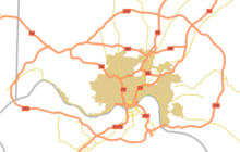
Interstate 275 (I-275) is an 83.71-mile-long (134.72 km) highway in Ohio, Indiana, and Kentucky that forms a complete beltway around the Cincinnati metropolitan area and includes a part in a state (Indiana) not entered by the parent route. It had been the only auxiliary Interstate that enters three states, but that changed in July 2018 when I-295 in Delaware and New Jersey was extended into Pennsylvania. It is the longest beltway with an Interstate highway designation in the United States, enclosing an area of over 250,000 acres (100,000 ha). It is also the third longest beltway overall in the United States—only the Sam Houston Tollway and the Grand Parkway encircling Greater Houston are longer. For a short distance in northwest Hamilton County, it overlaps with I-74 and US Route 52 (US 52).

EastPark is a 1000-acre (4 km2) industrial park located in the state of Kentucky, United States, at the junction of Boyd, Greenup, and Carter counties, although most of the park resides in Greenup County. The park is operated by the Northeast Kentucky Regional Industrial Park Authority. The site of the park was donated to the state of Kentucky by Addington Enterprises from reclaimed land that had once been used as a strip mine. The state of Kentucky used the donated land to build the park and a two-lane highway, now known as the Industrial Parkway This proved to be beneficial to both Addington and the state, as the land was not able to be developed without the road and it provided a way to connect US 23 in Greenup County to Interstate 64. The park has a convenient location, as it is located where Interstate 64 and KY 67 intersect. EastPark is also connected to a port on the Ohio River in Wurtland, Kentucky, via KY 67.

<span class="mw-page-title-main">Hebron, Kentucky</span> Unincorporated community in Kentucky, United States

Hebron is an unincorporated community and census-designated place (CDP) in Boone County, Kentucky, United States. It is named after the biblical city of Hebron. As of the 2020 census, it had a population of 6,195. The wider Hebron area is home to the Cincinnati/Northern Kentucky International Airport, which serves Cincinnati and the Tri-State (Ohio-Kentucky-Indiana) area.

<span class="mw-page-title-main">Geography of Louisville, Kentucky</span>

Louisville is a city in Jefferson County, in the U.S. state of Kentucky. It is located at the Falls of the Ohio River.

The Charleston Metropolitan Statistical Area, as defined by the United States Census Bureau, is an area consisting of three counties in West Virginia, anchored by the city of Charleston. It is the largest metropolitan area entirely within the state of West Virginia. The Huntington Metro Area adds to the Charleston–Huntington, WV-OH-KY CSA and spans three states, while the core county of the Charleston area, Kanawha County, is more populous than the West Virginia portion of the Huntington area.

The Cincinnati metropolitan area is a large, three-state media market centered on Cincinnati, Ohio, slightly overlapping the Dayton media market to the north. The Cincinnati market is served by one daily newspaper, The Cincinnati Enquirer, and a variety of weekly and monthly print publications. The area is home to 12 television stations and numerous radio stations. The E. W. Scripps Company was founded in Cincinnati as a newspaper chain and remains there as a national television and radio broadcaster. The term "soap opera" originally referred to Cincinnati-based Procter & Gamble, which created some of the first programs in this genre.

The Huntington–Ashland metropolitan area is a metropolitan area in the Appalachian Plateau region of the United States. Referred to locally as the "Tri-State area," and colloquially as "Kyova", the region spans seven counties in the three states of Kentucky, Ohio, and West Virginia. With a population of 361,580, the Tri-State area is nestled along the banks of the Ohio River. The region offers a diverse range of outdoor activities.

<span class="mw-page-title-main">Dayton metropolitan area</span> Metropolitan Statistical Area in Ohio, United States

Greater Dayton or the Miami Valley, or more formally the Dayton–Kettering–Beavercreek, OH Metropolitan Statistical Area, as defined by the United States Census Bureau, is an area consisting of three counties in the Miami Valley region of Ohio and is anchored by the city of Dayton. As of 2020, it is the fourth-largest metropolitan area in Ohio and the 73rd-largest metropolitan area by population in the United States with a population of 814,049.

<span class="mw-page-title-main">Transportation in Cincinnati</span>

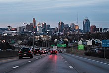
Transportation in Cincinnati includes sidewalks, roads, public transit, bicycle paths, and regional and international airports. Most trips are made by car, with transit and bicycles having a relatively low share of total trips; in a region of just over 2 million people, less than 80,000 trips are made with transit on an average day. The city is sliced by three major interstate highways, I-71, I-74 and I-75, and circled by a beltway several miles out from the city limits. The region is served by two separate transit systems, one on each side of the river. SORTA, on the Ohio side is about six times larger than TANK on the Kentucky side.

References

  1. "Greater Cincinnati Metro Region Resourcebook (Gallis Report)" (PDF). University of Cincinnati .
  2. "Census 2020: Cincy in a growth spurt; region gains 33 people every day".
  3. "Total Gross Domestic Product for Cincinnati, OH-KY-IN (MSA)". fred.stlouisfed.org.
  4. "2020 Census Urban Areas of the United States and Puerto Rico" (PDF). US Census Bureau. Retrieved July 26, 2023.
  5. "Federal Register/Vol. 75, No. 123/Monday, June 28, 2010/Notices" (PDF). US Census Bureau. Retrieved July 26, 2023.
  6. Table of United States Metropolitan Statistical Areas
  7. "Population Estimates" . Retrieved 2016-02-11.
  8. "OMB Bulletin No. 18-04" (PDF) (Press release). Office of Management and Budget. September 2018. p. 47.
  9. "OMB Bulletin No. 23-01" (PDF) (Press release). Office of Management and Budget. July 2023.
  10. "Ready for 'Daytonnati?' It could happen". Cincinnati.bizjournals.com. 1998-11-09. Retrieved 2012-05-14.
  11. DIvision, US Census Bureau Systems Support. "Ranking Tables for Metropolitan Areas (PHC-T-3)". www.census.gov.
  12. "Census 2020: Cincy in a growth spurt; region gains 33 people every day".
  13. "Archived copy" (PDF). Archived from the original (PDF) on March 20, 2009. Retrieved May 28, 2009.{{cite web}}: CS1 maint: archived copy as title (link)
  14. Ramon Jordan (2012-01-24). "National Arboretum – USDA Plant Hardiness Zone Map". Usna.usda.gov. Archived from the original on 2012-07-04. Retrieved 2016-05-25.
  15. "NowData—NOAA Online Weather Data". National Oceanic and Atmospheric Administration. Retrieved May 9, 2021.
  16. "Station: Cincinnati Northern KY AP, KY". U.S. Climate Normals 2020: U.S. Monthly Climate Normals (1991–2020). National Oceanic and Atmospheric Administration. Archived from the original on 2024-02-06. Retrieved May 9, 2021.
  17. "Records for Cincinnati". National Weather Service. Retrieved April 13, 2012.
  18. "WMO Climate Normals for CINCINNATI/GREATER CINCINNATI,KY 1961–1990". National Oceanic and Atmospheric Administration. Archived from the original on 2024-02-06. Retrieved July 25, 2020.
  19. "Cincinnati, Ohio, USA - Monthly weather forecast and Climate data". Weather Atlas. Retrieved July 4, 2019.
  20. "Cincinnati's Abandoned Subway". Archived from the original on July 27, 2019. Retrieved December 6, 2019.
  21. "CINCINNATI SUBWAY". Archived from the original on February 17, 2016. Retrieved February 16, 2016.
  22. "CVG Fact Sheet October 2020" (PDF). Retrieved 13 January 2021.
  23. "Amazon, DHL key in new CVG strategy to land development" . Retrieved 2 June 2018.
  24. "Cincinnati, OH: Cincinnati/ Northern Kentucky International (CVG)". Bureau of Transportation Statistics. May 2017. Retrieved May 11, 2018.
  25. "Launching Point 2017: A Year in Review" (PDF). Retrieved 5 February 2018.
  26. Rogers, Allison (January 12, 2019). "Winter weather update: Snow mixing with rain for some". WLWT . Hearst Television. Retrieved April 17, 2019.
  27. "Maps". WCPO-TV . E. W. Scripps Company. Retrieved April 17, 2019.
  28. "Cincinnati Maps". WKRC-TV . Sinclair Broadcast Group. Retrieved April 17, 2019.
  29. "Weather". WXIX-TV . Gray Television.

39°0′N84°30′W / 39.000°N 84.500°W / 39.000; -84.500