Bracken County, Kentucky

Last updated

Bracken County
Bracken county kentucky courthouse.jpg
Bracken County Courthouse in Brooksville
Map of Kentucky highlighting Bracken County.svg
Location within the U.S. state of Kentucky
Kentucky in United States.svg
Kentucky's location within the U.S.
Coordinates: 38°41′N84°05′W / 38.69°N 84.08°W / 38.69; -84.08
CountryFlag of the United States.svg United States
StateFlag of Kentucky.svg  Kentucky
Founded1796
Named for William Bracken
Seat Brooksville
Largest city Augusta
Area
  Total209 sq mi (540 km2)
  Land206 sq mi (530 km2)
  Water3.3 sq mi (9 km2)  1.6%
Population
 (2020)
  Total8,400
  Estimate 
(2023)
8,426 Increase2.svg
  Density40/sq mi (16/km2)
Time zone UTC−5 (Eastern)
  Summer (DST) UTC−4 (EDT)
Congressional district 4th
Website www.brackencounty.ky.gov

Bracken County is a county located in the U.S. state of Kentucky. As of the 2020 census, the population was 8,400. [1] Its county seat is Brooksville. [2] The county was formed in 1796. Bracken County is included in the Cincinnati-Middletown, OH-KY-IN Metropolitan Statistical Area.

Contents

History

Bracken County was organized as Kentucky's 23rd county in 1796 from parts of Mason and Campbell counties. [3] [4] It was named after two creeks, the Big and Little Bracken, which in turn were named for William Bracken, an 18th-century explorer and surveyor who visited the area in 1773. [5] He was later killed by Indians during the Northwest Indian War. The county originally extended to southern Nicholas County, north to the Ohio River, west to the Licking River and east to Dover, Kentucky. [6]

Several early settlers were veterans of the American Revolutionary War, including Captain Abner Howell, who brought his family came from Pennsylvania. He died in Bracken County in 1797.

The county government moved from Augusta to Woodward's Crossing (now Brooksville) in 1833.

Bracken was the birthplace of John Gregg Fee, founder of Berea College and Kentucky's most noted abolitionist. He was a graduate of Augusta College and Lane Theological Seminary. In 1822 Augusta College was founded as the first Methodist college in the world.

Anti-slavery activists in Bracken County played a major role in the movement known as the Underground Railroad. There are several Underground Railroad sites in the Augusta area. A network of citizens sympathetic to escaping slaves helped them cross the Ohio River to nearby Ripley, Ohio and other points north. [7]

Fields at the George Barkley Farm in Bracken County, Kentucky, where Webb and Fore obtained the first white burley seed George W. Barkley Farm fields.jpg
Fields at the George Barkley Farm in Bracken County, Kentucky, where Webb and Fore obtained the first white burley seed

Bracken County's economy was largely agricultural. Its chief crops before the Civil War were tobacco and corn. White burley tobacco, a light, adaptable leaf that revolutionized the industry, was first sold at the 1867 St. Louis Fair by the farmer Mr. Webb from Higginsport, Ohio. He had produced it in 1864 from Bracken County seed and developed the type. [8] It became a major product of central Kentucky and central Tennessee.

Agriculture remains vital to the economy, with farms occupying 83.8 percent of the land area in 1982. Commodities include wheat, hay, and milk. Burley tobacco production in 1988 amounted to 5,406,000 pounds. Agricultural receipts in 1986 totaled $19,158,000 (~$43.6 million in 2022). [9]

Historic schools

Augusta:

Brooksville:

Germantown:

Milford:

Law and government

Judge Executives
  1. Earl Bush (2011–Present)
  2. Gary Riggs (2007–2011)
  3. Leslie Newman (2002–2007)
  4. Dwayne "Pie" Jett (1987–2002)
United States presidential election results for Bracken County, Kentucky [10]
Year Republican Democratic Third party
No.%No.%No.%
2020 3,39880.03%80018.84%481.13%
2016 2,71176.86%70519.99%1113.15%
2012 2,02962.78%1,14735.49%561.73%
2008 2,06660.78%1,24136.51%922.71%
2004 2,36365.46%1,21333.60%340.94%
2000 2,06568.40%88829.41%662.19%
1996 1,37150.40%1,05538.79%29410.81%
1992 1,16239.63%1,25942.94%51117.43%
1988 1,63057.72%1,17641.64%180.64%
1984 1,81260.89%1,13638.17%280.94%
1980 1,15443.65%1,42053.71%702.65%
1976 87935.23%1,57763.21%391.56%
1972 1,62864.30%87334.48%311.22%
1968 1,11540.81%1,06739.06%55020.13%
1964 86130.54%1,95869.46%00.00%
1960 2,00260.16%1,32639.84%00.00%
1956 1,75453.54%1,51546.25%70.21%
1952 1,69049.07%1,75350.90%10.03%
1948 1,23939.13%1,86358.84%642.02%
1944 1,48343.40%1,91556.04%190.56%
1940 1,55144.05%1,96155.69%90.26%
1936 1,43641.70%1,95656.79%521.51%
1932 1,47137.52%2,40761.39%431.10%
1928 2,82069.98%1,20129.80%90.22%
1924 1,77951.67%1,48543.13%1795.20%
1920 1,79140.09%2,62158.66%561.25%
1916 1,08238.33%1,67659.37%652.30%
1912 69329.18%1,31555.37%36715.45%

Geography

According to the U.S. Census Bureau, the county has a total area of 209 square miles (540 km2), of which 206 square miles (530 km2) is land and 3.3 square miles (8.5 km2) (1.6%) is water. [11]

Adjacent counties

Demographics

Historical population
CensusPop.Note
1800 2,606
1810 3,70642.2%
1820 5,28042.5%
1830 6,51823.4%
1840 7,0538.2%
1850 8,90326.2%
1860 11,02123.8%
1870 11,4093.5%
1880 13,50918.4%
1890 12,369−8.4%
1900 12,137−1.9%
1910 10,308−15.1%
1920 10,210−1.0%
1930 9,616−5.8%
1940 9,389−2.4%
1950 8,424−10.3%
1960 7,422−11.9%
1970 7,227−2.6%
1980 7,7387.1%
1990 7,7660.4%
2000 8,2796.6%
2010 8,4882.5%
2020 8,400−1.0%
2023 (est.)8,426 [12] 0.3%
U.S. Decennial Census [13]
1790-1960 [14] 1900-1990 [15]
1990-2000 [16] 2010-2021 [17]

As of the census [18] of 2000, there were 8,279 people, 3,228 households, and 2,346 families residing in the county. The population density was 41 per square mile (16/km2). There were 3,715 housing units at an average density of 18 per square mile (6.9/km2). The racial makeup of the county was 98.48% White, 0.62% Black or African American, 0.25% Native American, 0.06% Asian, 0.04% Pacific Islander, 0.21% from other races, and 0.35% from two or more races. 0.47% of the population were Hispanic or Latino of any race.

There were 3,228 households, out of which 33.50% had children under the age of 18 living with them, 57.30% were married couples living together, 10.70% had a female householder with no husband present, and 27.30% were non-families. 23.90% of all households were made up of individuals, and 11.30% had someone living alone who was 65 years of age or older. The average household size was 2.55 and the average family size was 3.00.

In the county, the population was spread out, with 25.50% under the age of 18, 8.40% from 18 to 24, 29.50% from 25 to 44, 23.00% from 45 to 64, and 13.50% who were 65 years of age or older. The median age was 37 years. For every 100 females, there were 98.00 males. For every 100 females age 18 and over, there were 95.90 males.

The median income for a household in the county was $34,823, and the median income for a family was $40,469. Males had a median income of $31,503 versus $21,139 for females. The per capita income for the county was $16,478. About 7.60% of families and 10.80% of the population were below the poverty line, including 10.50% of those under age 18 and 17.30% of those age 65 or over.

Education

School districts include: [19]

Private schools:

Communities

Cities

Unincorporated Communities

Notable residents

See also

Related Research Articles

<span class="mw-page-title-main">Shelby County, Kentucky</span> County in Kentucky, United States

Shelby County is a county located in the U.S. state of Kentucky. As of the 2020 census, the population was 48,065. Its county seat is Shelbyville. The county was established in 1792 and named for Isaac Shelby, the first Governor of Kentucky. Shelby County is part of the Louisville/Jefferson County, KY–IN Metropolitan Statistical Area. Shelby County's motto is "Good Land, Good Living, Good People".

<span class="mw-page-title-main">Union County, Kentucky</span> County in Kentucky, United States

Union County is a county in the U.S. state of Kentucky. As of the 2020 census, the population was 13,668. Its county seat is Morganfield. The county was created effective January 15, 1811.

<span class="mw-page-title-main">Pendleton County, Kentucky</span> County in Kentucky, United States

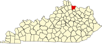
Pendleton County is a county located in the U.S. state of Kentucky. As of the 2020 census, the population was 14,644. Its county seat is Falmouth. The county was founded December 13, 1798. Pendleton County is included in the Cincinnati-Middletown, OH-KY-IN Metropolitan Statistical Area.

<span class="mw-page-title-main">Meade County, Kentucky</span> County in Kentucky, United States

Meade County is a county located in the U.S. state of Kentucky. As of the 2020 census, the population was 30,003. Its county seat is Brandenburg. The county was founded December 17, 1823, and named for Captain James M. Meade, who was killed in action at the Battle of River Raisin during the War of 1812. Meade County is part of the Elizabethtown-Fort Knox, KY Metropolitan Statistical Area, which is included in the Louisville/Jefferson County-Elizabethtown-Madison, KY-IN Combined Statistical Area.

<span class="mw-page-title-main">Mason County, Kentucky</span> County in Kentucky, United States

Mason County is a county located in the U.S. state of Kentucky. As of the 2020 census, the population was 17,120. Its county seat is Maysville. The county was created from Bourbon County, Virginia in 1788 and named for George Mason, a Virginia delegate to the U.S. Constitutional Convention known as the "Father of the Bill of Rights". Mason County comprises the Maysville, KY Micropolitan Statistical Area, which is included in the Cincinnati-Wilmington-Maysville, OH-KY-IN Combined Statistical Area.

<span class="mw-page-title-main">Madison County, Kentucky</span> County in Kentucky, United States

Madison County is a county located in the central part of the U.S. state of Kentucky. At the 2020 census, its population was 92,701. Its county seat is Richmond. The county is named for Virginia statesman James Madison, who later became the fourth President of the United States.

<span class="mw-page-title-main">Livingston County, Kentucky</span> County in Kentucky, United States

Livingston County is a county located in the U.S. state of Kentucky. As of the 2020 census, the population was 8,888. Its county seat is Smithland and its largest community is Ledbetter. The county was established in 1798 from land taken from Christian County and is named for Robert R. Livingston, a member of the Committee of Five that drafted the U.S. Declaration of Independence. The county was strongly pro-Confederate during the American Civil War and many men volunteered for the Confederate Army. Livingston County is part of the Paducah, KY-IL Metropolitan Statistical Area. It is a prohibition or dry county with the exception of Grand Rivers which voted to allow alcohol sales in 2016.

<span class="mw-page-title-main">Kenton County, Kentucky</span> County in Kentucky, United States

Kenton County is a county located in the northern part of the Commonwealth of Kentucky. As of the 2020 census, the population was 169,064, making it the third most populous county in Kentucky. Its county seats are Covington and Independence. It was, until November 24, 2010, the only county in Kentucky to have two legally recognized county seats. The county was formed in 1840 and is named for Simon Kenton, a frontiersman notable in the early history of the state.

<span class="mw-page-title-main">Jefferson County, Kentucky</span> County in Kentucky, United States

Jefferson County is located in the north central portion of the U.S. state of Kentucky. As of the 2020 census, the population was 782,969. It is the most populous county in the commonwealth.

<span class="mw-page-title-main">Harrison County, Kentucky</span> County in Kentucky, United States

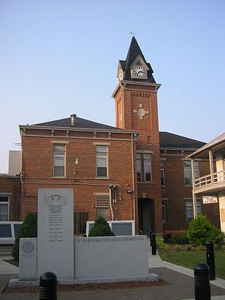
Harrison County is a county located in the U.S. state of Kentucky. As of the 2020 census, the population was 18,692. Its county seat is Cynthiana. The county was founded in 1793 and named for Colonel Benjamin Harrison, an advocate for Kentucky statehood, framer of the Kentucky Constitution, and Kentucky legislator.

<span class="mw-page-title-main">Hancock County, Kentucky</span> County in Kentucky, United States

Hancock County is a county located in the U.S. state of Kentucky. As of the 2020 census, the population was 9,095. Its county seat is in the city of Hawesville located in the Northern part of the county, and its largest city of Lewisport is located in the Northwestern part of the county.

<span class="mw-page-title-main">Grayson County, Kentucky</span> County in Kentucky, United States

Grayson County is a county located in the U.S. state of Kentucky. As of the 2020 census, the population was 26,420. Its county seat is Leitchfield. The county was formed in 1810 and named for William Grayson (1740–1790), a Revolutionary War colonel and a prominent Virginia political figure. Grayson County was formerly a prohibition or dry county, but Leitchfield allowed limited alcohol sales in restaurants in 2010 and voted "wet" in 2016.

<span class="mw-page-title-main">Campbell County, Kentucky</span> County in Kentucky, United States

Campbell County is a county located in the northern part of the U.S. state of Kentucky. As of the 2020 census, the population was 93,076. Its county seats are Alexandria and Newport. The county was formed on December 17, 1794, from sections of Scott, Harrison, and Mason Counties and was named for Colonel John Campbell (1735–1799), a Revolutionary War soldier and Kentucky legislator. Campbell County, with Boone and Kenton Counties, is part of the Northern Kentucky metro community, and the Cincinnati-Middletown, OH-KY-IN Metropolitan Statistical Area.

<span class="mw-page-title-main">Boyle County, Kentucky</span> County in Kentucky, United States

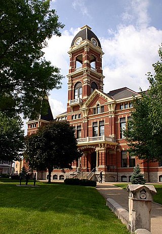
Boyle County is a county located in the central part of Kentucky. As of the 2020 census, the population was 30,614. Its county seat is Danville. The county was formed in 1842 and named for John Boyle (1774–1835), a U.S. Representative, chief justice of the Kentucky Court of Appeals, and later federal judge for the District of Kentucky, and is part of the Danville, KY Micropolitan Statistical Area.

<span class="mw-page-title-main">Augusta, Kentucky</span> City in Kentucky, United States

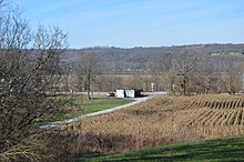
Augusta is a home rule-class city in Bracken County, Kentucky, in the United States. It is located upon the southern bank of the Ohio River. As of the 2020 census, the city population was 1,096. When Bracken County was organized in 1796, Augusta was the county seat. In 1839, a new county courthouse was built at a more central location in Brooksville. The city was formally incorporated by the state assembly in 1850.

<span class="mw-page-title-main">Brooksville, Kentucky</span> City in Kentucky, United States

Brooksville is a home rule-class city in Bracken County, Kentucky, in the United States. As of the 2010 census, the city's population was 642. It is the county seat of Bracken County.

<span class="mw-page-title-main">Melbourne, Kentucky</span> City in Kentucky, United States

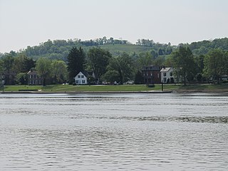
Melbourne is a home rule-class city in Campbell County, Kentucky, United States, along the south bank of the Ohio River. The population was 458 at the 2020 census. St. Anne Convent is located in Melbourne; scenes from the movie Rain Man were filmed there.

<span class="mw-page-title-main">Maysville, Kentucky</span> City in Kentucky, United States

Maysville is a home rule-class city in Mason County, Kentucky, United States, and is the seat of Mason County. The population was 8,873 as of the 2020 census. Maysville is on the Ohio River, 66 miles (106 km) northeast of Lexington. It is the principal city of the Maysville Micropolitan Statistical Area, which comprises Mason County. Two bridges cross the Ohio from Maysville to Aberdeen, Ohio: the Simon Kenton Memorial Bridge built in 1931 and the William H. Harsha Bridge built in 2001.

<span class="mw-page-title-main">Germantown, Kentucky</span> City in Kentucky, United States

Germantown is a home rule-class city in Bracken and Mason counties in the U.S. state of Kentucky. The population was 146 at the 2020 census.

<span class="mw-page-title-main">Knox County, Kentucky</span> County in Kentucky, United States

Knox County is a county located in Appalachia near the southeastern corner of the U.S. state of Kentucky. As of the 2020 census, the population was 30,193. Its county seat is Barbourville. The county is named for General Henry Knox. It is one of the few coal-producing counties in Kentucky that has not suffered massive population loss. Knox County is included in the London, KY Micropolitan Statistical Area.

References

  1. "Census - Geography Profile: Bracken County, Kentucky". United States Census Bureau . Retrieved December 30, 2022.
  2. "Find a County". National Association of Counties. Archived from the original on May 31, 2011. Retrieved June 7, 2011.
  3. Collins, Lewis (1882). Collins' Historical Sketches of Kentucky: History of Kentucky, Volume 2. Collins & Company. p. 26.
  4. "Bracken County". The Kentucky Encyclopedia. 2000. Archived from the original on August 21, 2014. Retrieved August 20, 2014.
  5. The Register of the Kentucky State Historical Society, Volume 1. Kentucky State Historical Society. 1903. pp.  34.
  6. "Bracken County History", Kentucky Historical Society
  7. "Underground Railroad" Archived September 21, 2006, at the Wayback Machine , Augusta, Kentucky Website
  8. J.M. Stoddart, Encyclopædia Britannica. American Supplement (Stoddart's Encyclopaedia Americana: A Dictionary of Arts, Sciences, and General Literature, and Companion to the Encyclopædia Britannica. (9th ed.) and to All Other Encyclopaedias, Volume 1), 1883, pp. 120–123, accessed February 5, 2011
  9. "Bracken County, KY", Genealogy Inc
  10. Leip, David. "Dave Leip's Atlas of U.S. Presidential Elections". uselectionatlas.org. Retrieved June 29, 2018.
  11. "2010 Census Gazetteer Files". United States Census Bureau. August 22, 2012. Archived from the original on August 12, 2014. Retrieved August 12, 2014.
  12. "Annual Estimates of the Resident Population for Counties: April 1, 2020 to July 1, 2023". United States Census Bureau. Retrieved March 14, 2024.
  13. "U.S. Decennial Census". United States Census Bureau. Retrieved August 12, 2014.
  14. "Historical Census Browser". University of Virginia Library. Retrieved August 12, 2014.
  15. "Population of Counties by Decennial Census: 1900 to 1990". United States Census Bureau. Retrieved August 12, 2014.
  16. "Census 2000 PHC-T-4. Ranking Tables for Counties: 1990 and 2000" (PDF). United States Census Bureau. Archived (PDF) from the original on March 27, 2010. Retrieved August 12, 2014.
  17. "State & County QuickFacts". United States Census Bureau. Archived from the original on June 7, 2011. Retrieved March 5, 2014.
  18. "U.S. Census website". United States Census Bureau . Retrieved January 31, 2008.
  19. "2020 CENSUS - SCHOOL DISTRICT REFERENCE MAP: Bracken County, KY" (PDF). U.S. Census Bureau. Archived (PDF) from the original on July 26, 2022. Retrieved July 25, 2022. - Text list - For more detailed boundaries of the independent school districts see: "Appendix B: Maps Of Independent School Districts In Operation In FY 2014-FY 2015 Using 2005 Tax District Boundaries – Augusta ISD" (PDF). Research Report No. 415 – Kentucky's Independent School Districts: A Primer. Frankfort, KY: Office of Education Accountability, Legislative Research Commission. September 15, 2015. p. 88 (PDF p. 102). Archived (PDF) from the original on December 10, 2020.

38°41′N84°05′W / 38.69°N 84.08°W / 38.69; -84.08