Morgan County, Indiana

Last updated

Morgan County
Morgan County Courthouse, Martinsville.jpg
Morgan County courthouse in Martinsville
Map of Indiana highlighting Morgan County.svg
Location within the U.S. state of Indiana
Indiana in United States.svg
Indiana's location within the U.S.
Coordinates: 39°29′N86°27′W / 39.48°N 86.45°W / 39.48; -86.45
CountryFlag of the United States.svg United States
StateFlag of Indiana.svg  Indiana
FoundedFebruary 15, 1822 (authorized)
December 1822 (organized)
Named for Gen. Daniel Morgan
Seat Martinsville
Largest cityMartinsville
Area
  Total409.43 sq mi (1,060.4 km2)
  Land403.97 sq mi (1,046.3 km2)
  Water5.46 sq mi (14.1 km2)  1.33%
Population
 (2020)
  Total71,780 Increase2.svg
  Density180/sq mi (70/km2)
Time zone UTC−5 (Eastern)
  Summer (DST) UTC−4 (EDT)
Congressional districts 4th, 9th
Website http://www.morgancounty.in.gov/
Indiana county number 55

Morgan County is a county located in the U.S. state of Indiana. As of the 2020 United States Census, the population was 71,780. [1] The county seat (and only incorporated city) is Martinsville. [2]

Contents

Morgan County is between Indianapolis, in Marion County, and Bloomington in Monroe County. It is included in the Indianapolis-Carmel-Anderson, IN Metropolitan Statistical Area. Two major highways, Interstate 69 and Indiana State Road 67, carry large numbers of daily commuters between the two larger communities. The county has 14 townships which provide local services. [3] [4]

History

The future state of Indiana was first regulated by passage of the Northwest Ordinance in 1787. The governing structure created by this act was superposed over an area that was still largely contested with the country's natives, although they were being gradually pushed out of the area. In 1818, a series of treaties was concluded, resulting in the confinement of the Miami tribe to the reserve area and the removal of the Delaware tribe, who had dominated central and east central Indiana, to west of the Mississippi River by 1820, clearing the way for colonization. The area was called the Delaware New Purchase until it was divided into Wabash County in the northwest and Delaware County in the southeast on January 2, 1820. Those counties were soon after dissolved, and the areas came to be called the "Wabash New Purchase" and "Delaware New Purchase" (renamed the "Adams New Purchase" in 1827). Subsequently, 35 new counties (including Morgan, authorized on February 15, 1822) were carved out of the original area. It was named for Gen. Daniel Morgan, who defeated the British at the Battle of Cowpens in the Revolutionary War.

The first settlers arrived in Morgan County in 1822. [5] They came mostly from southern states. The Mooresville area and surrounding communities received large numbers of southern Quakers, driven to migrate because of their opposition to slavery. Paul Hadley, a Mooresville resident, was the designer of the current Indiana flag, as well as a locally prominent water color artist in the early twentieth century.

In the late nineteenth and early twentieth centuries, mineral springs in Martinsville gave rise to several spas, and the nickname of the Martinsville High School athletic teams has subsequently been the Artesians.

County government took several steps forward in the 2000s, creating a new Plan Commission, re-instituting a county economic development organization, and establishing the county's first Park and Recreation Board between 2000 and 2004. Morgan County also was the first county in the metropolitan Indianapolis region to establish a smoking ban ordinance for restaurants, which came into effect in 2004. [6]

Courthouse

The first building used for Morgan County courts was the log house of a pioneer. Work began in 1823 to build the first courthouse, a two-story log house. A brick courthouse replaced it in 1833. [7]

The Morgan County courthouse was designed by Isaac Hodgson in the Italianate style. It was built from 1857 to 1859 by Perry M. Blankenship of Martinsville at a cost of $32,000. It was almost identical to Hodgson's Jennings County courthouse in Vernon, which was also begun in 1857, but the Martinsville building received an addition in the 1970s; the original section was also remodeled and renovated at that time. The building is of red brick with white stone quoins and has tall windows with round arches, arranged in pairs. It is one of the few remaining pre-Civil War courthouses. [8]

Geography

Morgan County is where the glaciers stopped their southward advance during the last ice age. As a result, the area has both flat areas and rolling hills, with the most diverse soil of any county in the United States. [9] The extensive woodlands of the eighteenth century have been cleared on the county's flat areas, with agricultural or urban uses dominating. The county is significantly carved with wooded drainages, leading to the southwest-flowing White River. [10] According to radar telemetry gathered by the US Shuttle Radar Topographic Mission, Morgan County terrain ranges from 604 to 1,010 feet (184 to 308 meters) ASL. [11]

According to the 2010 census, the county has a total area of 409.43 square miles (1,060.4 km2), of which 403.97 square miles (1,046.3 km2) (or 98.67%) is land and 5.46 square miles (14.1 km2) (or 1.33%) is water. [12] Morgan County is bisected by the White River Valley; the community has taken an interest in recent years in protecting the river as an asset, seeking to develop parks and greenways along the White River and initiating an annual river cleanup day in the spring.

The county also is home to large areas of land that were not glaciated during the last ice age. The river valley and contributing watersheds, along with the non-glaciated hills, results in a topography unlike the rest of the metropolitan Indianapolis area. County residents are proud of the scenic terrain, and in recent years have established a county park system and a bike/pedestrian trail system plan to provide protection and access to the amenities. An annual five miles (8.0 km) run is held as a fundraiser for the path system endowment. [13]

Adjacent counties

Major highways

Communities

City and towns

Unincorporated places

Townships

Morgan County Morgan county IN.jpg
Morgan County

Climate and weather

Martinsville, Indiana
Climate chart (explanation)
J
F
M
A
M
J
J
A
S
O
N
D
 
 
3.1
 
 
36
21
 
 
2.4
 
 
41
24
 
 
3.7
 
 
52
33
 
 
4.3
 
 
64
43
 
 
4.8
 
 
74
54
 
 
5
 
 
82
63
 
 
4.4
 
 
86
66
 
 
3.2
 
 
84
65
 
 
3.1
 
 
78
57
 
 
3.2
 
 
66
46
 
 
3.5
 
 
53
35
 
 
2.9
 
 
40
26
Average max. and min. temperatures in °F
Precipitation totals in inches
Source: The Weather Channel [14]
Metric conversion
J
F
M
A
M
J
J
A
S
O
N
D
 
 
79
 
 
2
−6
 
 
62
 
 
5
−4
 
 
94
 
 
11
1
 
 
110
 
 
18
6
 
 
121
 
 
23
12
 
 
126
 
 
28
17
 
 
112
 
 
30
19
 
 
81
 
 
29
18
 
 
80
 
 
26
14
 
 
82
 
 
19
8
 
 
88
 
 
12
2
 
 
74
 
 
4
−3
Average max. and min. temperatures in °C
Precipitation totals in mm

In recent years, average temperatures in Martinsville have ranged from a low of 18 °F (−8 °C) in January to a high of 85 °F (29 °C) in July, although a record low of −35 °F (−37 °C) was recorded in January 1994 and a record high of 105 °F (41 °C) was recorded in July 1954. Average monthly precipitation ranged from 2.44 inches (62 mm) in February to 4.73 inches (120 mm) in May. [14]

Government

The county government is a constitutional body granted specific powers by the Constitution of Indiana and the Indiana Code. The county council is the fiscal branch of the county government and controls spending and revenue collection. Four Council members are elected from county districts, and three are elected at-large by the entire county electorate. The council members serve four-year terms and are responsible for setting salaries, the annual budget and special spending. The council has limited authority to impose local taxes, in the form of optional income taxes and the property tax levy that is subject to state level approval, excise taxes and service taxes. [15] [16]

The executive body of the county; commissioners are elected county-wide to staggered four-year terms. One commissioner serves as president. The commissioners execute acts legislated by the council, collect revenue and manage the county government. [15] [16]

The county maintains a small claims court that handles civil cases. The judge on the court is elected to a term of four years and must be a member of the Indiana Bar Association. The judge is assisted by a constable who is elected to a four-year term. In some cases, court decisions can be appealed to the state level circuit court. [16]

The county has other elected offices, including sheriff, coroner, auditor, treasurer, recorder, surveyor and circuit court clerk. These officers are elected to four-year terms. Members elected to county government positions are required to declare party affiliations and be residents of the county. [16]

Each township has a trustee who administers rural fire protection and ambulance service, provides poor relief and manages cemetery care, among other duties. [4] The trustee is assisted in these duties by a three-member township board. The trustees and board members are elected to four-year terms. [17]

Morgan County is split between Indiana's fourth and ninth districts; Indiana Senate districts 35 and 37; [18] and Indiana House of Representatives districts 47 and 91. [19]

United States presidential election results for Morgan County, Indiana [20]
Year Republican Democratic Third party
No.%No.%No.%
2020 27,51275.96%7,78121.48%9282.56%
2016 23,67475.28%6,04019.21%1,7325.51%
2012 19,59169.17%7,96928.13%7652.70%
2008 18,12962.92%10,33035.85%3521.22%
2004 19,19773.75%6,65025.55%1820.70%
2000 15,28669.37%6,22828.26%5222.37%
1996 12,87259.60%5,81226.91%2,91213.48%
1992 10,93951.83%4,69022.22%5,47825.95%
1988 14,28472.38%5,37527.23%770.39%
1984 14,88475.91%4,62723.60%960.49%
1980 13,32168.53%5,43927.98%6783.49%
1976 10,98359.99%7,18139.22%1450.79%
1972 11,98077.62%3,39021.96%650.42%
1968 8,94455.45%4,04225.06%3,14419.49%
1964 8,34754.10%7,01145.44%700.45%
1960 9,41663.36%5,37536.17%690.46%
1956 8,31863.48%4,73536.14%500.38%
1952 8,22262.90%4,75536.38%950.73%
1948 5,67755.13%4,42843.00%1921.86%
1944 6,11559.09%4,15640.16%770.74%
1940 6,61357.29%4,89542.40%360.31%
1936 5,79351.14%5,45148.12%840.74%
1932 4,82544.70%5,77553.50%1951.81%
1928 5,46457.76%3,93341.58%630.67%
1924 5,32855.58%4,04242.17%2162.25%
1920 5,63455.95%4,25442.25%1811.80%
1916 2,86050.06%2,61645.79%2374.15%
1912 1,35324.23%2,60846.70%1,62329.07%
1908 3,07450.98%2,78946.25%1672.77%
1904 3,11954.12%2,42842.13%2163.75%
1900 2,90451.38%2,63246.57%1162.05%
1896 2,68852.23%2,41446.91%440.86%
1892 2,37751.28%2,01443.45%2445.26%
1888 2,50053.58%2,07744.51%891.91%

Demographics

Historical population
CensusPop.Note
1830 5,593
1840 10,74192.0%
1850 14,57635.7%
1860 16,11010.5%
1870 17,5288.8%
1880 18,9007.8%
1890 18,643−1.4%
1900 20,4579.7%
1910 21,1823.5%
1920 20,010−5.5%
1930 19,424−2.9%
1940 19,8011.9%
1950 23,72619.8%
1960 33,87542.8%
1970 44,17630.4%
1980 51,99917.7%
1990 55,9207.5%
2000 66,68919.3%
2010 68,8943.3%
2020 71,7804.2%
2023 (est.)73,227 [21] 2.0%
US Decennial Census [22]
1790-1960 [23] 1900-1990 [24]
1990-2000 [25] 2010 [26]

2010 Census

As of the 2010 United States Census, there were 68,894 people, 25,765 households, and 19,355 families in the county. [27] The population density was 170.5 inhabitants per square mile (65.8/km2). There were 27,754 housing units at an average density of 68.7 per square mile (26.5/km2). [12] The racial makeup of the county was 97.7% white, 0.4% Asian, 0.3% American Indian, 0.3% black or African American, 0.3% from other races, and 1.0% from two or more races. Those of Hispanic or Latino origin made up 1.2% of the population. [27] In terms of ancestry, 46% of people in Morgan County were of English ancestry, 22.1% were of German ancestry, and 10.3% were of Irish ancestry. Of the 25,765 households, 35.8% had children under the age of 18 living with them, 59.8% were married couples living together, 10.1% had a female householder with no husband present, 24.9% were non-families, and 20.3% of all households were made up of individuals. The average household size was 2.65 and the average family size was 3.04. The median age was 39.9 years. [27]

The median income for a household in the county was $47,697 and the median income for a family was $62,507. Males had a median income of $48,457 versus $34,831 for females. The per capita income for the county was $23,972. About 7.2% of families and 10.1% of the population were below the poverty line, including 14.9% of those under age 18 and 6.8% of those age 65 or over. [28]

Education

Morgan County is served by the Morgan County Public Library, which operates six branches. [29]

See also

Related Research Articles

<span class="mw-page-title-main">Adams County, Indiana</span> County in Indiana, United States

Adams County lies in northeastern Indiana in the United States and shares its eastern border with Ohio. It was officially established in 1836. The county seat is Decatur.

<span class="mw-page-title-main">Montgomery County, Indiana</span> County in Indiana, United States

Montgomery County is a county in the U.S. state of Indiana. As of the 2020 United States census, it had a population of 37,936. Its county seat is Crawfordsville. The county is divided into eleven townships which provide local services.

<span class="mw-page-title-main">Randolph County, Indiana</span> County in Indiana, United States

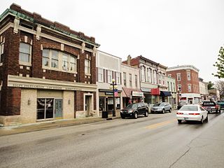
Randolph County is a county located in the central section of U.S. state of Indiana, on its eastern border with Ohio. As of 2020, the population was 24,502. The county seat is Winchester.

<span class="mw-page-title-main">Parke County, Indiana</span> County in Indiana, United States

Parke County lies in the western part of the U.S. state of Indiana along the Wabash River. The county was formed in 1821 out of a portion of Vigo County. According to the 2020 census, the population was 16,156. The county seat is Rockville.

<span class="mw-page-title-main">Owen County, Indiana</span> County in Indiana, United States

Owen County is a county in the U.S. state of Indiana. In 1920 the United States Census Bureau calculated the mean center of U.S. population to fall within this county. As of the 2020 United States Census, it had a population of 21,321. Its county seat is Spencer.

<span class="mw-page-title-main">Ohio County, Indiana</span> County in Indiana, United States

Ohio County is a county located in southeastern Indiana. With a 2020 population of 5,940, and an area of just 87 square miles, Ohio County is the smallest county in Indiana by area and the least populous. The county seat and only incorporated municipality is Rising Sun. The county was officially established in 1844 and was one of the last Indiana counties to be created. Ohio County borders the state of Kentucky across the Ohio River for which it was named. It is part of the Cincinnati, OH-KY-IN Metropolitan Statistical Area. The county is divided into four townships which provide local services. Three state roads pass through or into the county.

<span class="mw-page-title-main">Newton County, Indiana</span> County in Indiana, United States

Newton County is a county located near the northwestern corner of the U.S. state of Indiana. As of 2020, the population was 13,830. This county is part of Northwest Indiana as well as the Chicago metropolitan area. The county seat is Kentland. The county is divided into 10 townships which provide local services.

<span class="mw-page-title-main">Monroe County, Indiana</span> County in Indiana, United States

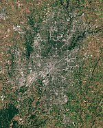
Monroe County is a county in the U.S. state of Indiana. In 1910 the US Census Bureau calculated the nation's mean population center to lie in Monroe County. The population was 139,718 at the 2020 United States Census. The county seat is Bloomington. Monroe County is part of the Bloomington, Indiana, Metropolitan Statistical Area.

<span class="mw-page-title-main">Madison County, Indiana</span> County in Indiana, United States

Madison County is a county in the U.S. state of Indiana. The 2020 census states the population is standing at 130,129. The county seat since 1836 has been Anderson, one of three incorporated cities within the county.

<span class="mw-page-title-main">Lawrence County, Indiana</span> County in Indiana, United States

Lawrence County is a county located in the U.S. state of Indiana. As of 2020, the population was 45,011. The county seat is Bedford. Lawrence County comprises the Bedford, IN Micropolitan Statistical Area.

<span class="mw-page-title-main">Johnson County, Indiana</span> County in Indiana, United States

Johnson County is a county located in the U.S. state of Indiana. As of 2020, the population was 161,765. The county seat is Franklin.

<span class="mw-page-title-main">Franklin County, Indiana</span> County in Indiana, United States

Franklin County is a county on the eastern border of the U.S. state of Indiana. In the 2020 United States Census, the county population was 22,785. The county seat is the town of Brookville. Franklin County is part of the Cincinnati, OH–KY–IN Metropolitan Statistical Area. The only incorporated city in Franklin County is Batesville, which lies mostly in adjoining Ripley County.

<span class="mw-page-title-main">Carroll County, Indiana</span> County in Indiana, United States

Carroll County is a county located in the U.S. state of Indiana. As of the 2020 United States Census, the population was 20,306. The county seat is Delphi.

<span class="mw-page-title-main">Brown County, Indiana</span> County in Indiana, United States

Brown County is a county in Indiana which in 2020 had a population of 15,475. The county seat is Nashville.

<span class="mw-page-title-main">Benton County, Indiana</span> County in Indiana, United States

Benton County is located in the northwest part of the U.S. state of Indiana, along the border with Illinois. As of 2020, the county's population was 8,719. It contains six incorporated towns as well as several small unincorporated settlements; it is divided into 11 townships which provide local services. The county seat is Fowler.

<span class="mw-page-title-main">Allen County, Indiana</span> County in Indiana, United States

Allen County is a county in the U.S. state of Indiana. As of the 2020 Census, the population was 385,410, making it the third-most populous county in Indiana. The county seat and largest city is Fort Wayne, the second largest city in Indiana.

<span class="mw-page-title-main">Martinsville, Indiana</span> City in Indiana, United States

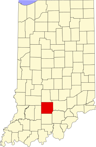
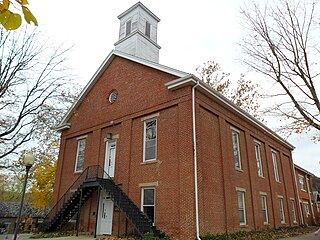
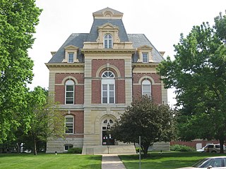
Martinsville is a city in Washington Township, Morgan County, in the U.S. state of Indiana. The population was 12,309 at the 2020 United States Census. The city is the county seat of Morgan County.

<span class="mw-page-title-main">Monrovia, Indiana</span> Town in Indiana, United States

Monrovia is a town in Monroe Township, Morgan County, in the U.S. state of Indiana. The population was 1,643 at the 2020 census, up from 1,063 in 2010.

<span class="mw-page-title-main">Mooresville, Indiana</span> Town in Indiana, United States

Mooresville is a town in Brown Township, Morgan County, in the U.S. state of Indiana. As of the 2020 census, the town population was 9,411.

Centerton is an unincorporated community and census-designated place (CDP) in Clay Township, Morgan County, in the U.S. state of Indiana.

References

  1. "Morgan County, Indiana". United States Census Bureau . Retrieved June 2, 2023.
  2. "Find a County – Morgan County IN". National Association of Counties. Archived from the original on December 10, 2017. Retrieved November 15, 2011.
  3. "Morgan". Indiana Township Association. Archived from the original on April 15, 2012. Retrieved November 15, 2011.
  4. 1 2 "Duties". United Township Association of Indiana. Retrieved January 6, 2011.
  5. History of Morgan County (Genealogy Trails, accessed 6 August 2020)
  6. "Morgan County adopts smoking ban". wthr.com. September 3, 2004. Retrieved March 30, 2023.
  7. Blanchard, Charles (1884). Counties of Morgan, Monroe and Brown, Indiana: Historical and Biographical. F.A. Battey & Co. p.  19.
  8. Counts, Will; Jon Dilts (1991). The 92 Magnificent Indiana Courthouses. Bloomington IN: Indiana University Press. pp. 116–7. ISBN   978-0-253-33638-5.
  9. History and Heritage (Visit Morgan County - accessed 6 August 2020)
  10. Morgan County IN (Google Maps, accessed 6 August 2020)
  11. Morgan County Topo Maps (anyplaceamerica.com - accessed 6 August 2020)
  12. 1 2 "Population, Housing Units, Area, and Density: 2010 - County". US Census Bureau. Archived from the original on February 12, 2020. Retrieved July 10, 2015.
  13. 20" Races to Run in 2020 (Visit Morgan County - accessed 6 August 2020)
  14. 1 2 "Monthly Averages for Martinsville IN". The Weather Channel. Retrieved January 27, 2011.
  15. 1 2 Indiana Code. "Title 36, Article 2, Section 3". Government of Indiana. Retrieved September 16, 2008.
  16. 1 2 3 4 Indiana Code. "Title 2, Article 10, Section 2" (PDF). Government of Indiana. Retrieved September 16, 2008.
  17. "Government". United Township Association of Indiana. Retrieved January 6, 2011.
  18. "Indiana Senate Districts". State of Indiana. Retrieved July 14, 2011.
  19. "Indiana House Districts". State of Indiana. Retrieved July 14, 2011.
  20. Leip, David. "Atlas of US Presidential Elections". uselectionatlas.org. Retrieved May 18, 2018.
  21. "Annual Estimates of the Resident Population for Counties: April 1, 2020 to July 1, 2023". United States Census Bureau. Retrieved April 2, 2024.
  22. "US Decennial Census". US Census Bureau. Retrieved July 10, 2014.
  23. "Historical Census Browser". University of Virginia Library. Retrieved July 10, 2014.
  24. "Population of Counties by Decennial Census: 1900 to 1990". US Census Bureau. Retrieved July 10, 2014.
  25. "Census 2000 PHC-T-4. Ranking Tables for Counties: 1990 and 2000" (PDF). US Census Bureau. Retrieved July 10, 2014.
  26. "Morgan County QuickFacts". US Census Bureau. Archived from the original on June 7, 2011. Retrieved September 25, 2011.
  27. 1 2 3 "Profile of General Population and Housing Characteristics: 2010 Demographic Profile Data". US Census Bureau. Archived from the original on February 13, 2020. Retrieved July 10, 2015.
  28. "Selected Economic Characteristics – 2006-2010 American Community Survey 5-Year Estimates". US Census Bureau. Archived from the original on February 14, 2020. Retrieved July 10, 2015.
  29. "Homepage". Morgan County Public Library. Retrieved March 10, 2018.

39°29′N86°27′W / 39.48°N 86.45°W / 39.48; -86.45