Hendricks County, Indiana

Last updated

Hendricks County
Hendricks County Indiana Courthouse.jpg
Hendricks County courthouse in Danville
Map of Indiana highlighting Hendricks County.svg
Location within the U.S. state of Indiana
Indiana in United States.svg
Indiana's location within the U.S.
Coordinates: 39°46′N86°31′W / 39.77°N 86.51°W / 39.77; -86.51
CountryFlag of the United States.svg United States
StateFlag of Indiana.svg  Indiana
FoundedDecember 20, 1823 (created) [1]
Summer 1824 (organized)
Named for William Hendricks
Seat Danville
Largest town Plainfield
Area
  Total408.78 sq mi (1,058.7 km2)
  Land406.91 sq mi (1,053.9 km2)
  Water1.87 sq mi (4.8 km2)  0.46%
Population
 (2020)
  Total174,788
  Density430/sq mi (170/km2)
Time zone UTC−5 (Eastern)
  Summer (DST) UTC−4 (EDT)
Congressional district 4th
Website www.co.hendricks.in.us
Indiana county number 32

Hendricks County is a county in the U.S. state of Indiana. As of the 2020 United States Census, the population was 174,788. [2] The county seat is the town of Danville. [3]

Contents

Hendricks County is the third largest county in the Indianapolis-Carmel-Anderson, IN Metropolitan Statistical Area. Hendricks County is currently the second fastest-growing county in Indiana and 85th in the nation. [4] [5]

History

After the American Revolutionary War established US sovereignty over the territory of the upper midwest, the new federal government defined the Northwest Territory in 1787 which included the area of present-day Indiana. In 1800, Congress separated Ohio from the Northwest Territory, designating the rest of the land as the Indiana Territory. President Thomas Jefferson chose William Henry Harrison as the governor of the territory, and Vincennes was established as the future capital. After the Michigan Territory was separated and the Illinois Territory was formed, Indiana was reduced to its current size and geography. By December 1816 the Indiana Territory was admitted to the Union as a state, although much of its territory was still in dispute as to possession by Native Americans. The land containing Hendricks County was brought into the possession of the United States by the Treaty of St. Mary's in 1818 (known as New Purchase).

The eighth General Assembly of the new state of Indiana met at its then-capital town, Corydon, in December 1823, and created three counties before the close of the session, among them being Hendricks, the state's fifty-first county. The bill creating Hendricks County was introduced in the Senate on December 9 and was signed on December 20 [1] by Indiana Governor William Hendricks, in whose honor the new county was named. [6] [7] Until its governing structure was organized, the territory was assigned to neighboring counties for legislative and enforcement matters. [8]

Prior to the New Purchase treaty, the territory of Hendricks County had been occupied by the Dakota tribe, although there were no significant native villages within its future borders. The treaty authorized the territory to be surveyed by the federal government, with land being available for settlement thereafter. This survey work began in the Hendricks County area in 1819, and settlers began moving in as soon thereafter (the first in future Hendricks County in Spring 1820) [9] as land filing was authorized, such that by 1823 there were sufficient inhabitants to justify forming a county. [10] Designated commissioners met in July 1824, and on July 12 selected Danville as its county seat. The town plat was filed for record in October 1824; a court house was erected and in operation there by 1826. [11]

Geography

The county's low rolling hills are entirely devoted to agriculture or urban development, except for wooded drainages. The West Fork of White Lick Creek flows southeastward through the western part of the county and the East Fork flows southward through the east part of the county; the two flows converge at the south county line. [12] The highest point on the terrain (1,030 feet/310 meters ASL) is a small rise 1.5 miles (2.4 km) WNW from Danville. [13]

According to the 2010 United States Census, the county has a total area of 408.78 square miles (1,058.7 km2), of which 406.91 square miles (1,053.9 km2) (or 99.54%) is land and 1.87 square miles (4.8 km2) (or 0.46%) is water. [14]

Adjacent counties

Towns

Unincorporated communities

Townships

Climate

Danville, Indiana
Climate chart (explanation)
J
F
M
A
M
J
J
A
S
O
N
D
 
 
2.5
 
 
34
18
 
 
2.4
 
 
40
23
 
 
3.4
 
 
51
32
 
 
3.6
 
 
63
41
 
 
4.4
 
 
74
52
 
 
4.1
 
 
82
61
 
 
4.4
 
 
86
65
 
 
3.8
 
 
84
63
 
 
2.9
 
 
77
55
 
 
2.8
 
 
66
44
 
 
3.6
 
 
52
34
 
 
3
 
 
39
24
Average max. and min. temperatures in °F
Precipitation totals in inches
Source: The Weather Channel [16]
Metric conversion
J
F
M
A
M
J
J
A
S
O
N
D
 
 
63
 
 
1
−8
 
 
61
 
 
4
−5
 
 
87
 
 
11
0
 
 
92
 
 
17
5
 
 
111
 
 
23
11
 
 
105
 
 
28
16
 
 
112
 
 
30
18
 
 
97
 
 
29
17
 
 
73
 
 
25
13
 
 
70
 
 
19
7
 
 
92
 
 
11
1
 
 
77
 
 
4
−4
Average max. and min. temperatures in °C
Precipitation totals in mm

In recent years, average temperatures in Danville have ranged from a low of 18 °F (−8 °C) in January to a high of 86 °F (30 °C) in July, although a record low of −27 °F (−33 °C) was recorded in January 1994 and a record high of 106 °F (41 °C) was recorded in July 1936. Average monthly precipitation ranged from 2.41 inches (61 mm) in February to 4.42 inches (112 mm) in July. [16]

Transportation

Airport

Major highways

Transit

Demographics

Historical population
CensusPop.Note
1830 3,975
1840 11,264183.4%
1850 14,08325.0%
1860 16,95320.4%
1870 20,27719.6%
1880 22,98113.3%
1890 21,498−6.5%
1900 21,292−1.0%
1910 20,840−2.1%
1920 20,291−2.6%
1930 19,725−2.8%
1940 20,1512.2%
1950 24,59422.0%
1960 40,89666.3%
1970 53,97432.0%
1980 69,80429.3%
1990 75,7178.5%
2000 104,09337.5%
2010 145,44839.7%
2020 174,78820.2%
2023 (est.)186,387 [17] 6.6%
US Decennial Census [18]
1790-1960 [19] 1900-1990 [20]
1990-2000 [21] 2010 [22]
Age and gender distribution in Hendricks County USA Hendricks County, Indiana age pyramid.svg
Age and gender distribution in Hendricks County

2010 census

As of the 2010 United States Census, there were 145,448 people, 52,368 households, and 39,698 families in the county. [23] The population density was 357.4 inhabitants per square mile (138.0/km2). There were 55,454 housing units at an average density of 136.3 per square mile (52.6/km2). [14] The racial makeup of the county was 90.1% white, 4.9% black or African American, 2.1% Asian, 0.2% American Indian, 1.1% from other races, and 1.6% from two or more races. Those of Hispanic or Latino origin made up 3.0% of the population. [23] In terms of ancestry, 28.3% were German, 16.2% were English, 15.2% were Irish, and 9.4% were American. [24]

Of the 52,368 households, 40.3% had children under the age of 18 living with them, 61.9% were married couples living together, 9.8% had a female householder with no husband present, 24.2% were non-families, and 19.8% of all households were made up of individuals. The average household size was 2.71 and the average family size was 3.12. The median age was 36.7 years. [23]

The median income for a household in the county was $47,697 and the median income for a family was $77,397. Males had a median income of $54,945 versus $38,919 for females. The per capita income for the county was $28,880. About 4.3% of families and 5.7% of the population were below the poverty line, including 7.3% of those under age 18 and 5.3% of those age 65 or over. [25]

Government and politics

The county government is a constitutional body, and is granted specific powers by the Constitution of Indiana, and by the Indiana Code.

County Council: The legislative branch of the county government; controls spending and revenue collection in the county. Representatives are elected to four-year terms from county districts. They set salaries, the annual budget, and special spending. The council has limited authority to impose local taxes, in the form of an income and property tax that is subject to state level approval, excise taxes, and service taxes. [26] [27]

Board of Commissioners: The executive body of the county; commissioners are elected county-wide to staggered four-year terms. One commissioner serves as president. The commissioners execute acts legislated by the council, collect revenue, and manage the county government. [26] [27]

Courts: The county has six trial courts consisting of a circuit court and five superior courts, the judges of which are elected to 6-year terms in a countywide election. In addition, two magistrates appointed by the elected judges serve the county as judicial officers. There are currently three town courts that also operate in Hendricks County, one each in Avon, Brownsburg, and Plainfield.

County Officials: The county has other elected offices, including sheriff, coroner, auditor, treasurer, recorder, surveyor, and circuit court clerk. These officers are elected to four-year terms. Members elected to county government positions are required to declare party affiliations and to be residents of the county. [27]

Hendricks County is part of Indiana's 4th congressional district, Indiana Senate districts 23 and 24, [28] and Indiana House of Representatives districts 28, 40, 47, and 91. [29]

Hendricks County is a Republican stronghold. In only one election (1912) was the county carried by a Democratic presidential candidate since 1888.

United States presidential election results for Hendricks County, Indiana [30]
Year Republican Democratic Third party
No.%No.%No.%
2020 53,80260.65%32,60436.76%2,2992.59%
2016 48,33763.45%22,60029.67%5,2476.89%
2012 44,31266.37%21,11231.62%1,3372.00%
2008 39,72861.07%24,54837.73%7781.20%
2004 38,43073.48%13,54825.90%3240.62%
2000 28,65171.23%10,78626.82%7841.95%
1996 22,29363.14%9,39226.60%3,62110.26%
1992 18,37355.45%7,07121.34%7,69223.21%
1988 22,09074.12%7,64325.65%700.23%
1984 21,30775.73%6,65923.67%1690.60%
1980 19,36668.88%7,41226.36%1,3394.76%
1976 16,72564.07%9,06634.73%3131.20%
1972 17,69979.89%4,38419.79%700.32%
1968 12,59759.89%5,15524.51%3,28015.60%
1964 11,49756.34%8,85743.41%510.25%
1960 12,49065.51%6,48133.99%950.50%
1956 10,57865.58%5,52134.23%300.19%
1952 9,71266.58%4,79332.86%810.56%
1948 6,32759.23%4,28040.07%750.70%
1944 6,67360.45%4,29738.93%690.63%
1940 6,78257.92%4,88341.70%450.38%
1936 5,77652.05%5,23747.19%840.76%
1932 5,31749.15%5,29348.93%2071.91%
1928 5,95464.79%3,18134.61%550.60%
1924 5,76661.02%3,48936.92%1942.05%
1920 6,29359.20%4,19239.44%1451.36%
1916 3,04653.13%2,45342.79%2344.08%
1912 1,43926.15%2,37243.10%1,69230.75%
1908 3,23154.28%2,57143.19%1512.54%
1904 3,43458.82%2,16437.07%2404.11%
1900 3,42657.65%2,35939.69%1582.66%
1896 3,40958.06%2,36540.28%981.67%
1892 3,02056.35%2,02837.84%3115.80%
1888 3,29758.62%2,08337.04%2444.34%

See also

Related Research Articles

<span class="mw-page-title-main">Vanderburgh County, Indiana</span> County in Indiana, United States

Vanderburgh County is a county in the U.S. state of Indiana. As of 2020, the population was 180,136. The county seat is in Evansville. While Vanderburgh County was the eighth-largest county in 2020 population in Indiana, it is also the eighth-smallest county in area and the smallest in southwestern Indiana, covering only 236 square miles (610 km2).

<span class="mw-page-title-main">Switzerland County, Indiana</span> County in Indiana, United States

Switzerland County is a county in the southeast corner of the U.S. state of Indiana. As of the 2020 United States Census, the population was 9,737. The county seat is Vevay, one of two incorporated towns in the county.

<span class="mw-page-title-main">Shelby County, Indiana</span> County in Indiana, United States

Shelby County is a county in the U.S. state of Indiana. As of the 2020 United States Census, the population was 45,055. The county seat is Shelbyville.

<span class="mw-page-title-main">Pulaski County, Indiana</span> County of Indiana, United States

Pulaski County is a county located in the U.S. state of Indiana. According to the 2020 U.S. census, the population was 12,514. The county seat is Winamac.

<span class="mw-page-title-main">Posey County, Indiana</span> County in Indiana, United States

Posey County is the southernmost, southwesternmost, and westernmost county in the U.S. state of Indiana. Its southern border is formed by the Ohio River, and its western border by the Wabash River, a tributary to the Ohio. As of 2020, the population was 25,222. The county seat is Mount Vernon.

<span class="mw-page-title-main">Pike County, Indiana</span> County in Indiana, United States

Pike County is a county in the southwest portion of the U.S. state of Indiana. As of the 2020 United States census, the population was 12,250. The county seat is Petersburg. It contains the geographic point representing median center of US population in 2010.

<span class="mw-page-title-main">Miami County, Indiana</span> County in Indiana, United States

Miami County is a county located in the U.S. state of Indiana. As of 2020, the population was 35,962. The county seat is the City of Peru. Miami County is part of the Kokomo-Peru CSA.

<span class="mw-page-title-main">Marshall County, Indiana</span> County in Indiana, United States

Marshall County is a county in the U.S. state of Indiana. The 2020 census recorded the population at 46,095. The county seat is Plymouth.

<span class="mw-page-title-main">Knox County, Indiana</span> County in Indiana, United States

Knox County is a county in the U.S. state of Indiana in the United States. The oldest county in Indiana, it was one of two original counties created in the Northwest Territory in 1790, alongside St. Clair County, Illinois. Knox County was gradually reduced in size as subsequent counties were established. It was established in its present configuration when Daviess County was partitioned off. At the 2020 United States Census, the county population was 36,282. The county seat is Vincennes.

<span class="mw-page-title-main">Jay County, Indiana</span> County in Indiana, United States

Jay County is a county in the U.S. state of Indiana. As of 2020, the population was 20,478. The county seat is Portland.

<span class="mw-page-title-main">Howard County, Indiana</span> County in Indiana, United States

Howard County is one of 92 counties in the U.S. state of Indiana. As of the 2020 census, the population was 83,658. The county seat is Kokomo. Originally named Richardville County, it was renamed in 1844 to commemorate General Tilghman Ashurst Howard.

<span class="mw-page-title-main">Greene County, Indiana</span> County in Indiana, United States

Greene County is a county in the U.S. state of Indiana. As of 2020, the population was 30,803. The county seat is Bloomfield. The county was determined by the US Census Bureau to include the mean center of U.S. population in 1930.

<span class="mw-page-title-main">Fayette County, Indiana</span> County in Indiana, United States

Fayette County is one of 92 counties in U.S. state of Indiana located in the east central portion of the state. As of 2020, the population was 23,398. Most of the county is rural; land use is farms, pasture and unincorporated woodland. The county seat and only incorporated town is Connersville, which holds a majority of the county's population.

<span class="mw-page-title-main">Decatur County, Indiana</span> County in Indiana, United States

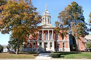
Decatur County is a county in the U.S. state of Indiana. As of the 2020 United States Census, the population was 26,472. The county seat is Greensburg.

<span class="mw-page-title-main">Daviess County, Indiana</span> County in Indiana, United States

Daviess County is a county in the U.S. state of Indiana. As of the 2020 United States Census, the population was 33,381. The county seat is Washington. About 15% of the county's population is Amish of Swiss origin, as of 2017.

<span class="mw-page-title-main">Boone County, Indiana</span> County in Indiana, United States

Boone County is a county in the U.S. state of Indiana. As of 2020, the population was 70,812. The county seat is Lebanon.

<span class="mw-page-title-main">Avon, Indiana</span> Town in Indiana, United States

Avon is a town in Washington Township, Hendricks County, Indiana, United States. The population was 21,474 at the 2020 census. It is part of the Indianapolis metropolitan area.

<span class="mw-page-title-main">Clayton, Indiana</span> Town in Indiana, United States

Clayton is a small town in Liberty Township, Hendricks County, Indiana, United States. The population was 972 at the 2010 census, up from 693 at the 2000 census.

<span class="mw-page-title-main">Danville, Indiana</span> Town in Indiana, United States

Danville is a town in and the county seat of Hendricks County, Indiana, United States. The population was 9,001 at the 2010 census, up from 6,418 at the 2000 census. In 2019 the estimated population was 10,126.

<span class="mw-page-title-main">Stilesville, Indiana</span> Town in Indiana, United States

Stilesville is a town in Franklin Township, Hendricks County, Indiana, United States. The population was 316 at the 2010 Census.

References

  1. 1 2 Hadley (1914), p. 8. However, p. 44 of Hadley gives date as December 29, 1823.
  2. "Hendricks County, Indiana". United States Census Bureau . Retrieved May 30, 2023.
  3. "Find a County". National Association of Counties. Archived from the original on May 31, 2011. Retrieved June 7, 2011.
  4. Hendricks County ranks 85th in population growth
  5. "Counties in Indiana". Archived from the original on September 27, 2011. Retrieved December 30, 2007.
  6. "Profile for Hendricks County IN". ePodunk. Archived from the original on November 13, 2012. Retrieved September 22, 2012.
  7. Gannett, Henry (1905). The Origin of Certain Place Names in the United States. Govt. Print. Off. p. 154.
  8. Hadley, John V. History of Hendricks County, Indiana. BF Brown Co., Indianapolis. pp. 8, 44, 45 (1914)
  9. Hadley (1914), p. 42
  10. Hadley (1914), p. 41
  11. Hadley (1914), p. 46
  12. Hendricks County IN (Google Maps, accessed 29 August 2020)
  13. Hendricks County High Point, Indiana (PeakBagger.com, accessed 29 August 2020)
  14. 1 2 "Population, Housing Units, Area, and Density: 2010 - County". US Census Bureau. Archived from the original on February 13, 2020. Retrieved July 10, 2015.
  15. Clermont Heights, Lincoln Township IN (Google Maps, accessed 29 August 2020)
  16. 1 2 "Monthly Averages for Danville IN". The Weather Channel. Retrieved January 27, 2011.
  17. "Annual Estimates of the Resident Population for Counties: April 1, 2020 to July 1, 2023". United States Census Bureau. Retrieved April 2, 2024.
  18. "US Decennial Census". US Census Bureau. Retrieved July 10, 2014.
  19. "Historical Census Browser". University of Virginia Library. Retrieved July 10, 2014.
  20. "Population of Counties by Decennial Census: 1900 to 1990". US Census Bureau. Retrieved July 10, 2014.
  21. "Census 2000 PHC-T-4. Ranking Tables for Counties: 1990 and 2000" (PDF). US Census Bureau. Retrieved July 10, 2014.
  22. "Hendricks County QuickFacts". US Census Bureau. Archived from the original on June 7, 2011. Retrieved September 20, 2011.
  23. 1 2 3 "Profile of General Population and Housing Characteristics: 2010 Demographic Profile Data". US Census Bureau. Archived from the original on February 13, 2020. Retrieved July 10, 2015.
  24. "Selected Social Characteristics in the US – 2006-2010 American Community Survey 5-Year Estimates". US Census Bureau. Archived from the original on February 14, 2020. Retrieved July 10, 2015.
  25. "Selected Economic Characteristics – 2006-2010 American Community Survey 5-Year Estimates". US Census Bureau. Archived from the original on February 14, 2020. Retrieved July 10, 2015.
  26. 1 2 Indiana Code. "Title 36, Article 2, Section 3". IN.gov. Retrieved September 16, 2008.
  27. 1 2 3 Indiana Code. "Title 2, Article 10, Section 2" (PDF). IN.gov. Retrieved September 16, 2008.
  28. "Indiana Senate Districts". State of Indiana. Retrieved July 14, 2011.
  29. "Indiana House Districts". State of Indiana. Retrieved July 14, 2011.
  30. Leip, David. "Atlas of US Presidential Elections". uselectionatlas.org. Retrieved May 17, 2018.

Further reading

39°46′N86°31′W / 39.77°N 86.51°W / 39.77; -86.51