Shelby County, Indiana

Last updated

Shelby County
Shelby County Courthouse in Shelbyville.jpg
Shelby County Courthouse in Shelbyville
Map of Indiana highlighting Shelby County.svg
Location within the U.S. state of Indiana
Indiana in United States.svg
Indiana's location within the U.S.
Coordinates: 39°31′N85°47′W / 39.52°N 85.79°W / 39.52; -85.79
CountryFlag of the United States.svg United States
StateFlag of Indiana.svg  Indiana
FoundedDecember 31, 1821 (authorized)
1822 (organized)
Named for Isaac Shelby
Seat Shelbyville
Largest cityShelbyville
Area
  Total412.76 sq mi (1,069.0 km2)
  Land411.15 sq mi (1,064.9 km2)
  Water1.61 sq mi (4.2 km2)  0.39%
Population
 (2020)
  Total45,055
  Density110/sq mi (42/km2)
Time zone UTC−5 (Eastern)
  Summer (DST) UTC−4 (EDT)
Congressional district 6th
Website www.co.shelby.in.us
Indiana county number 48

Shelby County is a county in the U.S. state of Indiana. As of the 2020 United States Census, the population was 45,055. [1] The county seat (and only incorporated city) is Shelbyville. [2]

Contents

History

After the American Revolutionary War established US sovereignty over the territory of the upper midwest, the new federal government defined the Northwest Territory in 1787, which included the area of present-day Indiana. In 1800, Congress separated Ohio from the Northwest Territory, designating the rest of the land as the Indiana Territory. President Thomas Jefferson chose William Henry Harrison as the governor of the territory, and Vincennes was established as the capital. After the Michigan Territory was separated and the Illinois Territory was formed, Indiana was reduced to its current size and geography. By December 1816 the Indiana Territory was admitted to the Union as a state.

The Native people who inhabited these areas prior to arrival of European settlers were generally resistant to the loss of their lands. As settlers pushed into the area, treaties signed by some leaders with United States representatives ceded large areas of their territory to the US. Starting in 1794, Native American titles to Indiana lands were extinguished by usurpation, purchase, or war and treaty. The United States acquired land from the Native Americans in the 1809 treaty of Fort Wayne, and by the treaty of St. Mary's in 1818, which included the future Shelby County.

The Indiana State Legislature passed a bill on December 31, 1821, that authorized the creation of four counties, [3] including Shelby. On July 1, 1822, the county was organized, beginning with selecting a site for the county seat. [4]

The new county was named for Gen. Isaac Shelby, who defeated the British at the Battle of Kings Mountain in the Revolutionary War. Shelby then became the first Governor of Kentucky. During the War of 1812, he led the army of Kentucky into Canada, and defeated the British at the decisive Battle of the Thames in 1813.

Geography

The low, rolling hills of Shelby County are lightly carved by drainages, but are otherwise completely devoted to agriculture or urban development. The western edge of the county is drained by Sugar Creek, flowing south-southwestward into Johnson County. The central and SW parts of the county are drained by Big Blue River, flowing south-southwestward into Johnson County. The lower part of the county is drained by Flatrock River, flowing southwestward into Bartholomew County. [5] The terrain slopes to the southwest, with its highest elevations (930 feet/280 meters ASL) along the eastern part of its northern border with Hancock County. [6] According to the 2010 census, the county has a total area of 412.76 square miles (1,069.0 km2), of which 411.15 square miles (1,064.9 km2) (or 99.61%) is land and 1.61 square miles (4.2 km2) (or 0.39%) is water. [7]

City and towns

Unincorporated communities

Townships

Adjacent counties

Major highways

Climate and weather

Shelbyville, Indiana
Climate chart (explanation)
J
F
M
A
M
J
J
A
S
O
N
D
 
 
2.4
 
 
35
18
 
 
2.4
 
 
40
22
 
 
3.4
 
 
51
31
 
 
3.9
 
 
63
41
 
 
4.5
 
 
73
52
 
 
3.9
 
 
82
61
 
 
4
 
 
86
65
 
 
3.5
 
 
84
63
 
 
2.7
 
 
78
55
 
 
2.8
 
 
66
43
 
 
3.6
 
 
52
35
 
 
2.8
 
 
40
24
Average max. and min. temperatures in °F
Precipitation totals in inches
Source: The Weather Channel [8]
Metric conversion
J
F
M
A
M
J
J
A
S
O
N
D
 
 
60
 
 
2
−8
 
 
60
 
 
4
−6
 
 
87
 
 
11
−1
 
 
100
 
 
17
5
 
 
114
 
 
23
11
 
 
100
 
 
28
16
 
 
102
 
 
30
18
 
 
89
 
 
29
17
 
 
70
 
 
26
13
 
 
72
 
 
19
6
 
 
90
 
 
11
2
 
 
71
 
 
4
−4
Average max. and min. temperatures in °C
Precipitation totals in mm

In recent years, average temperatures in Shelbyville have ranged from a low of 18 °F (−8 °C) in January to a high of 86 °F (30 °C) in July, although a record low of −25 °F (−32 °C) was recorded in January 1994 and a record high of 105 °F (41 °C) was recorded in July 1954. Average monthly precipitation ranged from 2.38 inches (60 mm) in January to 4.47 inches (114 mm) in May. [8]

2010 Census

As of the 2010 United States Census, there were 44,436 people, 17,302 households, and 12,221 families in the county. [9] The population density was 108.1 inhabitants per square mile (41.7/km2). There were 19,080 housing units at an average density of 46.4 per square mile (17.9/km2). [7] The racial makeup of the county was 95.4% white, 1.0% black or African American, 0.5% Asian, 0.2% American Indian, 1.6% from other races, and 1.2% from two or more races. Those of Hispanic or Latino origin made up 3.7% of the population. [9] In terms of ancestry, 28.5% were German, 13.1% were American, 12.2% were Irish, and 9.0% were English. [10]

Of the 17,302 households, 33.8% had children under the age of 18 living with them, 54.4% were married couples living together, 10.5% had a female householder with no husband present, 29.4% were non-families, and 24.5% of all households were made up of individuals. The average household size was 2.53 and the average family size was 2.98. The median age was 39.9 years. [9]

The median income for a household in the county was $47,697 and the median income for a family was $60,824. Males had a median income of $46,325 versus $32,416 for females. The per capita income for the county was $26,398. About 7.4% of families and 10.0% of the population were below the poverty line, including 13.7% of those under age 18 and 10.5% of those age 65 or over. [11]

Government

The county government is a constitutional body, and is granted specific powers by the Constitution of Indiana, and by the Indiana Code.

County Council: The legislative branch of the county government; controls spending and revenue collection in the county. Representatives are elected to four-year terms from county districts. They set salaries, the annual budget, and special spending. The council has limited authority to impose local taxes, in the form of an income and property tax that is subject to state level approval, excise taxes, and service taxes. [12] [13]

Board of Commissioners: The executive body of the county; commissioners are elected county-wide to staggered four-year terms. One commissioner serves as president. The commissioners execute the acts legislated by the council, collect revenue, and manage the county government. [12] [13]

Court: Three State Trial Courts sit in the Courthouse located at 407 S. Harrison Street, Shelbyville, Indiana 46176. Shelby Circuit Court was established by the Indiana Constitution. Shelby Superior Courts 1 and 2 were created by Acts of the Legislature. Shelby Superior Court 2 handles the small claims. Cases are allocated between the Courts by Local Court Rules. The judges of the Shelby Cirucit and Superior Courts are elected to six (6) year terms and must be admitted to practice law in the State of Indiana. Appeals from Shelby County Trial Courts are made to the Indiana Court of Appeals.

County Officials: The county has other elected offices, including sheriff, coroner, auditor, treasurer, recorder, surveyor, and circuit court clerk. These officials are elected to four-year terms. Members elected to county government positions are required to declare party affiliations and to be residents of the county. [13]

Political culture

United States presidential election results for Shelby County, Indiana [14]
Year Republican Democratic Third party
No.%No.%No.%
2020 14,56872.78%5,02325.09%4262.13%
2016 12,71870.34%4,24723.49%1,1156.17%
2012 10,97865.50%5,35931.97%4232.52%
2008 10,33358.70%6,98739.69%2821.60%
2004 11,39771.11%4,51928.20%1110.69%
2000 9,59062.64%5,37435.10%3462.26%
1996 7,77851.37%5,37435.49%1,99013.14%
1992 8,07549.81%4,56028.13%3,57622.06%
1988 10,17665.14%5,38234.45%630.40%
1984 11,05666.92%5,35732.42%1090.66%
1980 10,49661.20%5,86134.17%7934.62%
1976 8,91855.22%7,09843.95%1340.83%
1972 10,79472.44%4,02827.03%780.52%
1968 8,57452.84%5,41733.38%2,23513.77%
1964 7,31044.42%9,07855.17%670.41%
1960 9,42156.75%7,11142.83%700.42%
1956 9,17058.00%6,56141.50%800.51%
1952 8,96157.18%6,55241.81%1581.01%
1948 6,06845.54%6,99252.48%2641.98%
1944 6,81649.63%6,79849.50%1190.87%
1940 7,21647.02%8,01552.22%1170.76%
1936 6,02640.95%8,55258.11%1390.94%
1932 5,41038.05%8,55260.14%2571.81%
1928 7,51656.14%5,79043.24%830.62%
1924 6,66451.52%5,97646.20%2962.29%
1920 6,33647.15%6,84550.94%2561.91%
1916 3,20142.90%3,90052.27%3604.83%
1912 1,25417.34%3,43247.47%2,54435.19%
1908 3,52944.54%4,03550.93%3594.53%
1904 3,66048.21%3,55046.76%3825.03%
1900 3,29144.76%3,84652.31%2162.94%
1896 3,21944.62%3,82853.06%1672.31%
1892 2,66440.65%3,49053.26%3996.09%
1888 2,87744.41%3,40952.62%1922.96%

Demographics

Historical population
CensusPop.Note
1830 6,295
1840 12,00590.7%
1850 15,50229.1%
1860 19,56926.2%
1870 21,89211.9%
1880 25,25715.4%
1890 25,4540.8%
1900 26,4914.1%
1910 26,8021.2%
1920 25,982−3.1%
1930 26,5522.2%
1940 25,953−2.3%
1950 28,0268.0%
1960 34,09321.6%
1970 37,79710.9%
1980 39,8875.5%
1990 40,3071.1%
2000 43,4457.8%
2010 44,4362.3%
2020 45,0551.4%
2023 (est.)45,231 [15] 0.4%
US Decennial Census [16]
1790-1960 [17] 1900-1990 [18]
1990-2000 [19] 2010 [20]

Notable people

See also

Related Research Articles

<span class="mw-page-title-main">Shelby County, Kentucky</span> County in Kentucky, United States

Shelby County is a county located in the U.S. state of Kentucky. As of the 2020 census, the population was 48,065. Its county seat is Shelbyville. The county was established in 1792 and named for Isaac Shelby, the first Governor of Kentucky. Shelby County is part of the Louisville/Jefferson County, KY–IN Metropolitan Statistical Area. Shelby County's motto is "Good Land, Good Living, Good People".

<span class="mw-page-title-main">Shelby County, Missouri</span> County in Missouri, United States

Shelby County is a county located in the northeastern portion of the U.S. state of Missouri. As of the 2020 census, the population was 6,103. Its county seat is Shelbyville. The county was established on January 2, 1835, and named for Governor Isaac Shelby of Kentucky.

<span class="mw-page-title-main">Whitley County, Indiana</span> County in Indiana, United States

Whitley County is a rural county in the U.S. state of Indiana. As of the 2020 United States census, the population was 36,825. Whitley County is the 49th largest county in Indiana. The county seat is Columbia City. The county has the highest county number (92) on Indiana license plates, as it is alphabetically the last in the state's list of counties. It is part of the Fort Wayne Metropolitan Statistical Area and the Fort Wayne–Huntington–Auburn Combined Statistical Area.

<span class="mw-page-title-main">Union County, Indiana</span> County in Indiana, United States

Union County is a county in the U.S. state of Indiana. As of the 2020 United States census, the population was 7,087. The county seat is Liberty.

<span class="mw-page-title-main">Owen County, Indiana</span> County in Indiana, United States

Owen County is a county in the U.S. state of Indiana. In 1920 the United States Census Bureau calculated the mean center of U.S. population to fall within this county. As of the 2020 United States Census, it had a population of 21,321. Its county seat is Spencer.

<span class="mw-page-title-main">Martin County, Indiana</span> County in Indiana, United States

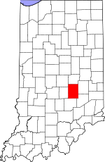
Martin County is a county in the U.S. state of Indiana. As of the 2020 United States Census, the population was 9,812. The county seat is Shoals at the center of the county, and the county's only incorporated city is Loogootee, on the county's western border.

<span class="mw-page-title-main">Madison County, Indiana</span> County in Indiana, United States

Madison County is a county in the U.S. state of Indiana. The 2020 census states the population is standing at 130,129. The county seat since 1836 has been Anderson, one of three incorporated cities within the county.

<span class="mw-page-title-main">Johnson County, Indiana</span> County in Indiana, United States

Johnson County is a county located in the U.S. state of Indiana. As of 2020, the population was 161,765. The county seat is Franklin.

<span class="mw-page-title-main">Hendricks County, Indiana</span> County in Indiana, United States

Hendricks County is a county in the U.S. state of Indiana. As of the 2020 United States Census, the population was 174,788. The county seat is the town of Danville.

<span class="mw-page-title-main">Hancock County, Indiana</span> County in Indiana, United States

Hancock County is a county in the U.S. state of Indiana. The 2020 United States Census recorded a population of 79,840. The county seat is Greenfield.

<span class="mw-page-title-main">Grant County, Indiana</span> County in Indiana, United States

Grant County is a county in central Indiana in the United States Midwest. At the time of the 2020 census, the population was 66,674. The county seat is Marion. Important paleontological discoveries, dating from the Pliocene epoch, have been made at the Pipe Creek Sinkhole in Grant County.

<span class="mw-page-title-main">Decatur County, Indiana</span> County in Indiana, United States

Decatur County is a county in the U.S. state of Indiana. As of the 2020 United States Census, the population was 26,472. The county seat is Greensburg.

<span class="mw-page-title-main">Carroll County, Indiana</span> County in Indiana, United States

Carroll County is a county located in the U.S. state of Indiana. As of the 2020 United States Census, the population was 20,306. The county seat is Delphi.

<span class="mw-page-title-main">Boone County, Indiana</span> County in Indiana, United States

Boone County is a county in the U.S. state of Indiana. As of 2020, the population was 70,812. The county seat is Lebanon.

<span class="mw-page-title-main">Shelby County, Illinois</span> County in Illinois, United States

Shelby County is a county located in the U.S. state of Illinois. According to the 2020 census, it had a population of 20,990. Its county seat is Shelbyville.

<span class="mw-page-title-main">Shelbyville, Illinois</span> City in Illinois, United States

Shelbyville is a city in and the county seat of Shelby County, Illinois, United States, along the Kaskaskia River. As of the 2020 census, the population was at 4,674. HSHS Good Shepherd Hospital, located in town, is the county's only hospital. Shelbyville is also home to Chautauqua Auditorium.

<span class="mw-page-title-main">Fairland, Indiana</span> Town in Indiana, United States

Fairland is a town in Brandywine Township, Shelby County, Indiana. The population was 315 at the 2010 census.

<span class="mw-page-title-main">Shelbyville, Indiana</span> City in Indiana, United States

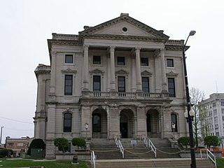
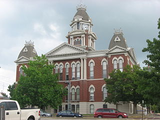
Shelbyville is a city in Addison Township, Shelby County, in the U.S. state of Indiana and is the county seat. The population was 20,067 as of the 2020 census.

<span class="mw-page-title-main">Shelbyville, Missouri</span> City in Missouri, United States

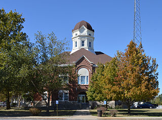
Shelbyville is a city in Shelby County, Missouri, United States. The population was 518 at the 2020 census. It is the county seat of Shelby County.

<span class="mw-page-title-main">DeKalb County, Indiana</span> County in Indiana, United States

DeKalb County is a county in the U.S. state of Indiana. As of the 2020 United States Census, the population was 43,265. The county seat is Auburn.

References

  1. "Shelby County, Indiana". United States Census Bureau . Retrieved June 7, 2023.
  2. "Find a County". National Association of Counties. Retrieved June 7, 2011.
  3. The counties authorized on December 31, 1821, were Henry, Marion, Rush, and Shelby.
  4. Shelby County Indiana History (1876), pp. 6-9 (accessed 14 August 2020)
  5. Shelby County IN (Google Maps, accessed 14 August 2020)
  6. Shelby County High Point, Indiana (PeakBagger.com, accessed 14 August 2020)
  7. 1 2 "Population, Housing Units, Area, and Density: 2010 - County". US Census Bureau. Archived from the original on February 12, 2020. Retrieved July 10, 2015.
  8. 1 2 "Monthly Averages for Shelbyville IN". The Weather Channel. Retrieved January 27, 2011.
  9. 1 2 3 "Profile of General Population and Housing Characteristics: 2010 Demographic Profile Data". US Census Bureau. Archived from the original on February 13, 2020. Retrieved July 10, 2015.
  10. "Selected Social Characteristics in the US – 2006-2010 American Community Survey 5-Year Estimates". US Census Bureau. Archived from the original on February 14, 2020. Retrieved July 10, 2015.
  11. "Selected Economic Characteristics – 2006-2010 American Community Survey 5-Year Estimates". US Census Bureau. Archived from the original on February 14, 2020. Retrieved July 10, 2015.
  12. 1 2 Indiana Code. "Title 36, Article 2, Section 3". IN.gov. Retrieved September 16, 2008.
  13. 1 2 3 Indiana Code. "Title 2, Article 10, Section 2" (PDF). IN.gov. Retrieved September 16, 2008.
  14. Leip, David. "Atlas of US Presidential Elections". uselectionatlas.org.
  15. "Annual Estimates of the Resident Population for Counties: April 1, 2020 to July 1, 2023". United States Census Bureau. Retrieved April 2, 2024.
  16. "US Decennial Census". US Census Bureau. Retrieved July 10, 2014.
  17. "Historical Census Browser". University of Virginia Library. Retrieved July 10, 2014.
  18. "Population of Counties by Decennial Census: 1900 to 1990". US Census Bureau. Retrieved July 10, 2014.
  19. "Census 2000 PHC-T-4. Ranking Tables for Counties: 1990 and 2000" (PDF). US Census Bureau. Retrieved July 10, 2014.
  20. "Shelby County QuickFacts". US Census Bureau. Archived from the original on June 7, 2011. Retrieved September 25, 2011.

39°31′N85°47′W / 39.52°N 85.79°W / 39.52; -85.79