Greenwood, Indiana

Last updated

Greenwood, Indiana
City
Greenwood City Center.jpg
Greenwood City Hall
Nickname(s): 
City of Pride and Progress
Johnson County Indiana Incorporated and Unincorporated areas Greenwood Highlighted 1829898.svg
Location of Greenwood in Johnson County, Indiana
Coordinates: 39°36′41″N86°07′05″W / 39.61139°N 86.11806°W / 39.61139; -86.11806
CountryUnited States
State Indiana
County Johnson
Townships Pleasant, White River, Clark
Government
  MayorMark W. Myers (R) [1]
Area
[2]
  Total27.91 sq mi (72.28 km2)
  Land27.91 sq mi (72.28 km2)
  Water0.00 sq mi (0.00 km2)
Elevation
[3]
804 ft (245 m)
Population
 (2020)
  Total63,830
  Density2,287.24/sq mi (883.12/km2)
Time zone UTC−5 (EST)
  Summer (DST) UTC−4 (EDT)
ZIP codes
46142-46143
Area code 317
FIPS code 18-29898 [4]
GNIS feature ID2394244 [3]
Website www.greenwood.in.gov

Greenwood is a city in Johnson County, Indiana, United States. The population was 63,830 at the 2020 Census. Greenwood is located southeast of central Indianapolis between Indiana State Road 37 and Interstate 65. The city shares a border with Indianapolis and is the most populous suburban municipality in the southern portion of the Indianapolis Metropolitan Area.

Contents

History

The first inhabitants of the area currently known as Greenwood were the Delaware Indians (Lenape). In 1818, the Treaty of St. Mary's opened central Indiana to European American settlement, and by 1823 the first cabin in northern Johnson County was erected by settlers John B. and Isaac Smock on land now occupied by Greenwood Park Mall. [5] Greenwood was first known as "Smocktown" or "Smock's Settlement" in honor of the Smock brothers, and became "Greenfield" in 1825. Since this clashed with another Greenfield located in Hancock County, the name of the settlement was changed to "Greenwood" in 1833. [6]

Greenwood was incorporated as a town under Indiana law in 1864. [7]

Greenwood was an early and key cog in the Electric Indianapolis Interurban Railway System. In 1895, Henry L. Smith proposed and organized the Indianapolis, Greenwood & Franklin Company and graded the line to Greenwood. The Indianapolis, Greenwood & Franklin Railway was opened between Indianapolis and Greenwood on January 1, 1900, and, according to Indianapolis historian Jacob Piatt Dunn, was the Hoosier capital's first real interurban electric railway. [8] The railway followed what is now Madison Avenue.

The J.T. Polk Canning Company was essential to Greenwood's early growth. The cannery was a major employer and canned a variety of vegetables grown in Indiana. Later, the company expanded into the dairy market and provided milk delivery to customers. At one point the cannery was the largest canning operation west of Baltimore. [5] The cannery was eventually purchased by the Stokely-Van Camp company and retained operations in Greenwood until the 1950s. Portions of the cannery are still standing on Main Street and have been repurposed for professional office space. [9]

Greenwood became a fifth-class city in 1960. [10]

In February 1965, an Indiana Civil Rights Commission report found that Greenwood had recently been one of 19 sundown towns in Indiana, where African Americans were not allowed to live or stay after dark. The city had been exclusively white since the 1920s. The report analyzes Greenwood's housing problem within African American families in the few years leading up to 1965. The analysis confirms a study regarding poorly constructed homes on the outskirts of Greenwood and a purchased house bought by an African American family that sold below $15,000. Racial tensions rose when the family introduced themselves to their new neighbors. In response, the neighbors presented the African American family with hostile threats. In the aftermath, the owners revoked their sale from the housing market. [11] [12]

Greenwood has long been a rightward-leaning community politically. After the founding of the John Birch Society in Indianapolis in 1958, a landmark for many years on the south side, adjacent to U.S. Route 31, was a Society billboard demanding "Get US out! of the United Nations".

Greenwood Commercial Historic District was listed on the National Register of Historic Places in 1991. This district encompasses 25 buildings and 3.2 acres (1.3 hectares). [13]

In 2010, the Greenwood City Council approved a measure to change the official status of Greenwood to a second-class city in accordance with Indiana Code Title 36, Article 4, Chapter 1. [14]

On July 17, 2022, three people were killed and two others wounded after a mass shooting occurred at the food court of Greenwood Park Mall. The gunman was subsequently shot and killed by an armed civilian who witnessed the shooting. [15]

Geography

Location and area

Greenwood is in northern Johnson County and occupies the northern half of Pleasant Township and the northeast portion of White River Township. The easternmost edge of Greenwood extends into Clark Township. It is bordered to the southwest by Bargersville, to the south by Whiteland and New Whiteland, and to the north, in Marion County, by the city of Indianapolis. Greenwood is 11 miles (18 km) south of Downtown Indianapolis and 12 miles (19 km) north of Franklin, the Johnson county seat.

According to the 2020 census, Greenwood has a total area of 27.91 square miles (72.29 km2), of which 27.91 square miles (72.29 km2) (or 100%) is land and 0.00 square miles (0.00 km2) (or 0%) is water. [16]

Greenwood's mean elevation is 804 feet (245 m) above sea level. The city's topography is flat to gently rolling.

Bodies of water

There are no navigable bodies of water within city limits. Several creeks run through the area and influence local drainage patterns, topography, and storm water management systems. Pleasant Run Creek flows from east to west across the northern half of the city, leading 5 miles (8 km) to the White River. Several municipal parks occupy the lowlands next to the creek. Grassy Creek and Tracy Ditch flow south from the city, connecting Greenwood to the towns of New Whiteland, Whiteland, and Franklin. Honey Creek originates in the southwest section of the city and after flowing through White River Township eventually joins the White River near the intersection of Smith Valley Road and Highway 37. [17]

Climate

Greenwood's climate is classified as warm temperate (Cfa) by the Köppen-Geiger system, with an average annual temperature of 54.3 °F (12.4 °C). About 45 inches (1,100 mm) of precipitation falls annually, distributed fairly evenly throughout the year.

Climate data for Greenwood
MonthJanFebMarAprMayJunJulAugSepOctNovDecYear
Mean daily maximum °F (°C)37.2
(2.9)
41.2
(5.1)
52.0
(11.1)
64.4
(18.0)
73.6
(23.1)
82.0
(27.8)
85.2
(29.6)
84.3
(29.1)
78.7
(25.9)
66.2
(19.0)
52.4
(11.3)
40.7
(4.8)
63.2
(17.3)
Daily mean °F (°C)29.9
(−1.2)
32.7
(0.4)
42.7
(5.9)
54.2
(12.3)
64.2
(17.9)
72.8
(22.7)
76.4
(24.7)
75.5
(24.2)
68.8
(20.4)
56.5
(13.6)
43.9
(6.6)
33.5
(0.8)
54.3
(12.4)
Mean daily minimum °F (°C)22.9
(−5.1)
24.7
(−4.1)
33.8
(1.0)
45.1
(7.3)
55.4
(13.0)
63.8
(17.7)
66.9
(19.4)
66.1
(18.9)
59.9
(15.5)
48.8
(9.3)
37.5
(3.1)
27.8
(−2.3)
46.1
(7.8)
Average precipitation inches (mm)3.3
(84)
3.0
(76)
4.0
(100)
5.0
(130)
5.2
(130)
4.5
(110)
3.6
(91)
2.9
(74)
3.1
(79)
3.3
(84)
3.5
(89)
3.6
(91)
45
(1,138)
Average precipitation days (≥ 0.01 in)778910997667893
Average relative humidity (%)69676766676869676365707268
Mean daily sunshine hours 4.85.67.18.59.710.710.710.18.87.26.14.77.8
Source: Climate-Data.org [18]

Parks

Over the years, Greenwood has constructed 17 parks that span upwards of 400 acres of land; furthermore, amongst these parks, there are more than 20 lineal miles of trailways for walking and biking, and many of them run through green spaces and wooded areas. [19] Some of the parks, such as City Center Park or Freedom Park, provide children with the opportunity to have outdoor activity through amenities spanning anywhere from slides to splash pads.

  1. Children's Garden Park: Located at 201 E Main St, this park offers a calm, natural environment for people located in the Old Town area. Fountains and other ornamental additions can be found throughout this park, and the gazebo can be rented for private events and gatherings.
  2. City Center Park: Located on Lincoln St, City Center Park is found right along the outskirts of Downtown, Greenwood. This park offers a multitude of resources for children to play outside, and it is one of the parks that feature a splash pad.
  3. Craig Park: Located at 10 E Smith Valley Rd, this park is one of the city's most known, including amenities such as playgrounds, tennis courts, pickleball courts, walkways, and more. Adults and children alike can utilize this space for outdoor activity, and it has rental options for the gazebo and shelters are available.
  4. Freedom Park: Located at 850 W Stop 18 Rd, and Freedom Park's amenities are extensive, arguably making it one of the city's most popular outdoor attractions. Walking trails spanning 1.5 mi, a large playground, and various sporting courts and fields are available, this park surrounds Freedom Springs Aquatic Center - one of Greenwood's busiest summer attractions.
  5. Grassy Creek Park: Located at 602 E Worthsville Rd, this park offers an outdoor area for residents closer to the Whiteland area. Sitting near Central Nine Education Center, Grassy Creek Park's 5 mi of trails give students and residents opportunities for outside exercise.
  6. Northeast Park: Located at 100 Crestview Dr, this park is directly adjacent to Northeast Elementary School, and it spans 19 acres of land. Amenities include attractions such as a skate park, playground equipment, various sporting courts/fields, and two picnic shelters.
  7. Northwest Park: Located at 1300 W Fry Rd, Northwest Park is one of the largest parks in greenwood, covering over 12 acres of land. This park can be described as having a much more open space for people to walk, featuring much more landscape than construction, but there is still a playground near the entrance off of Fry.
  8. Northwest Park Annex: Located at 1576 W Fry Rd, this park is exclusively designed to attract those who want to walk in nature filled landscape. 20 acres of walking trails take park-goers into the forest, and much of the area is rather untouched by construction.
  9. Old City Park: Located at 304 S Meridian St, Old City Park is a newly renovated attraction for residents of the Greenwood area. With extensive work done on landscaping, sidewalks, and playground equipment, this park showcases the amenities of a modern park.
  10. Summerfield Park: Located at 275 W Worthsville Rd, Summerfield Park spans 16 acres of open land right outside of growing residential areas in Greenwood. This park showcases wide area for walking or other outside activity, and a large shelter house is available for rent.
  11. Surina Square Park: Located at 100 Surina Way, this park is near many of Greenwood's local city resources, which include the following: Greenwood Community Center, Greenwood Amphitheater, Greenwood Police Department, Greenwood City Court, and Greenwood Fire Station 91. This park does not have many amenities, but its location is optimal during event season in the city.
  12. Trails Park: Located at 1600 W Fry Road, Trails park is a small area designed for flood prevention. As a result, this park's two acres are only accessible by foot.
  13. University Park: Located on 200 Legacy Blvd, this park covers 40 acres of land directly in between developed residential areas. Amenities include walking trails, a large playground, a dog park, and a basketball court. Additionally, a pavilion and shelter are both available for rent.
  14. Westside Park: Located at 820 W Main St, this park is known for its walking paths along Pleasant Creek. In addition to its paths, varying sporting areas, picnicking options, playground equipment, and other amenities take up the 27 acres of park. Much like the other parks, Westside has a shelter available for rent.
  15. Woodmen Park: Located at 720 Ashmore Dr, Woodmen park border the land directly next to Greenwood High School. This park offers multiple courts and fields for sporting activity, and it also holds a few playgrounds. Its shelter is available for rental.
  16. Community Garden: Located at 1190 W Fry Rd, this garden is open to all members of the Greenwood community. Many organizations use this land to grow food for unprivileged populations, and it is also available for private use through rental.
  17. Northeast Skatepark: Located at 100 Crestview Dr, this skatepark is a part of Northeast park, and it offers people the opportunity to skateboard on a concrete area. It has been recently renovated in 2021.

Transportation

Transit

Access Johnson County provides fixed-route and demand-response bus services in the city. [20]

IndyGo routes 16, 31, and 902 serve retail districts in northern Greenwood and offer transfers to Access Johnson County transit routes. [21]

Road and street network

According to Greenwood's most recent Comprehensive Annual Financial Report, there were 209.6 miles (337.3 km) of public streets within the city limits as of 2015. [22]

Major east-west arterial routes in Greenwood are not numbered and include County Line Road, Fry Road, Main Street, Smith Valley Road, Stop 18 Road, and Worthsville Road. Greenwood's system of east–west streets and roads link residents and businesses in White River Township with the business and neighborhoods adjacent to Interstate 65.

Most major north–south corridors in Greenwood are numbered and are not property of the city. U.S. 31, State Road 135, and Interstate 65 serve as the major north–south routes in the city. Greenwood owns and maintain three secondary corridors east of U.S. 31: Madison Avenue connects the Greenwood Park Mall to the Old Town Historic District; Emerson Avenue serves as a major commercial and business corridor and connects St. Francis Hospital in Indianapolis to Smith Valley Road; and Graham Road, located east of Interstate 65, connects County Line Road to Worthsville Road and serves several large distribution centers.

Interstate access

As of 2019, three exits connect Greenwood to Interstate 65. The most recently constructed interchange, Exit 97 (Worthsville Road), features a diverging diamond traffic design. It is one of two such installations in Indiana. [23] The remaining two interchanges, Exit 99 (Main Street) and Exit 101 (County Line Road), use conventional diamond and parclo A4 configurations, respectively. All three interchanges serve major commercial and industrial zones in the city.

Airport

Railroad

Freight rail service is provided by the Louisville and Indiana Railroad (LIRC). The LIRC line traverses Greenwood from north to south and roughly parallels U.S. 31 and Interstate 65.

Demographics

Historical population
CensusPop.Note
1880 448
1890 86292.4%
1900 1,50374.4%
1910 1,6087.0%
1920 1,90718.6%
1930 2,37724.6%
1940 2,4995.1%
1950 3,06622.7%
1960 7,169133.8%
1970 11,86965.6%
1980 19,32762.8%
1990 26,26535.9%
2000 36,03737.2%
2010 49,79138.2%
2020 63,83028.2%
U.S. Decennial Census [24]

2010 Census

As of the census [25] of 2010, there were 49,791 people, 19,615 households, and 12,845 families residing in the city. The population density was 2,345.3 inhabitants per square mile (905.5/km2). There were 21,339 housing units at an average density of 1,005.1 per square mile (388.1/km2). The racial makeup of the city was 91.1% White, 1.7% African American, 0.3% Native American, 3.7% Asian, 0.1% Pacific Islander, 2.1% from other races, and 2.1% from two or more races. Hispanic or Latino of any race were 4.0% of the population.

There were 19,615 households, of which 35.7% had children under the age of 18 living with them, 49.2% were married couples living together, 11.6% had a female householder with no husband present, 4.8% had a male householder with no wife present, and 34.5% were non-families. 27.8% of all households were made up of individuals, and 8.9% had someone living alone who was 65 years of age or older. The average household size was 2.51 and the average family size was 3.09.

The median age in the city was 34 years. 26.6% of residents were under the age of 18; 9% were between the ages of 18 and 24; 29.8% were from 25 to 44; 23.1% were from 45 to 64; and 11.6% were 65 years of age or older. The gender makeup of the city was 48.4% male and 51.6% female.

2000 Census

As of the census [4] of 2000, there were 36,037 people, 14,931 households, and 9,600 families residing in the city. The population density was 2,524.8 inhabitants per square mile (974.8/km2). There were 16,042 housing units at an average density of 1,123.9 per square mile (433.9/km2). The racial makeup of the city was 96.54% White, 0.44% African American, 0.19% Native American, 1.36% Asian, 0.04% Pacific Islander, 0.69% from other races, and 0.74% from two or more races. Hispanic or Latino of any race were 1.91% of the population.

There were 14,931 households, out of which 32.4% had children under the age of 18 living with them, 51.0% were married couples living together, 9.9% had a female householder with no husband present, and 35.7% were non-families. 29.9% of all households were made up of individuals, and 9.9% had someone living alone who was 65 years of age or older. The average household size was 2.37 and the average family size was 2.97.

In the city, the population was spread out, with 25.3% under the age of 18, 9.6% from 18 to 24, 32.1% from 25 to 44, 20.7% from 45 to 64, and 12.3% who were 65 years of age or older. The median age was 34 years. For every 100 females, there were 91.9 males. For every 100 females age 18 and over, there were 87.6 males.

The median income for a household in the city was $46,176, and the median income for a family was $57,298. Males had a median income of $40,291 versus $28,936 for females. The per capita income for the city was $23,003. About 4.6% of families and 7.0% of the population were below the poverty line, including 8.5% of those under age 18 and 9.4% of those age 65 or over

Economic environment

Top employment sectors

According to the Johnson County Chamber of Commerce's Labor Force Report, [26] in 2023 Greenwood had a total of 3,176 business establishments, employing 25,386 individuals. The principal employers in the city by Standard Industrial Classification categories are:

RankSIC Categories# of employees% of total employment
1Services (SIC Range 70–89)8,89635.04%
2Retail Trade (SIC 52–59)7,22628.46%
3Transportation and Communications (SIC 40–49)2,3829.38%
4Construction (SIC 15–17)2,2208.74%
5Finance, Insurance, and Real Estate (SIC 60–69)2,1088.30%
6Manufacturing (SIC 20–39)1,0814.26%
7Wholesale Trade (SIC 50–51)1,0464.12%
8Agricultural, Forestry, Fishing (SIC 01–09)2140.84%
9Public Administration (SIC 90–98)2110.83%

Notable businesses

Greenwood is home to the headquarters or other major facilities for several large businesses. The U.S. headquarters for Swiss process automation company Endress+Hauser is located in the southern portion of the city, immediately east of US 31 between Worthsville Road and Pushville Road. In 2014, the company completed construction of a new 80,000 square feet (7,400 m2) customer center on its Greenwood Campus. [27] Nachi Fujikoshi's subsidiary Nachi America Inc., a producer of machine tools, maintains its corporate campus and manufacturing facilities on Pushville Road in Greenwood. [28] Amazon operates a fulfillment center near Worthsville Road and Interstate 65 that employs around 1,000 people. [29] In late 2020, power tool manufacturer Milwaukee Electric Tool established its second U.S. service hub at Greenwood's Southtech Business Park; the facility commenced operations in May 2021. [30] [31]

Four craft breweries are located within Greenwood, including Oaken Barrel Brewing Co., which has called Greenwood home since its opening in 1994. Oaken Barrel is the second oldest brewpub in Indiana. [32]

In the fall of 2022, the home office of CALLERLAB, the International Association of Square Dance Callers, moved from Topeka, Kansas to an office complex near Emerson Avenue and Main Street in Greenwood. [33]

Education

Educational attainment

91.1% of Greenwood residents are high school graduates or higher. 31.1% of residents have attained a bachelor's degree or higher. [34]

Public schools

Three public school corporations serve Greenwood residents: [35] Greenwood Community School Corporation, [36] Clark-Pleasant Community School Corporation, [37] and Center Grove Community School Corporation. [38]

Greenwood Community School Corporation

High School

Middle School

  • Greenwood Community Middle School

Elementary Schools

  • Southwest Elementary School
  • Northeast Elementary School
  • V.O. Isom Elementary School
  • Westwood Elementary School

Clark-Pleasant Community School Corporation

High School

Middle School

  • Clark-Pleasant Middle School

Elementary Schools

  • Clark Elementary School
  • Grassy Creek Elementary School
  • Pleasant Crossing Elementary School

Center Grove Community School Corporation

High School

Middle Schools

  • Center Grove Middle School Central
  • Center Grove Middle School North

Elementary Schools

  • Center Grove Elementary School
  • North Grove Elementary School
  • Pleasant Grove Elementary School
  • Sugar Grove Elementary School
  • Maple Grove Elementary School
  • Walnut Grove Elementary School

Private schools

Colleges and universities

Public library

The city is served by the Greenwood Public Library. [46] The Johnson County Public Library also operates a separate branch within Greenwood city limits. [47]

See also

Related Research Articles

<span class="mw-page-title-main">Porter County, Indiana</span> County in Indiana, United States

Porter County is a county in the U.S. state of Indiana. As of 2020, the population was 173,215, making it the 10th most populous county in Indiana. The county seat is Valparaiso. The county is part of Northwest Indiana, as well as the Chicago metropolitan area. Porter County is the site of much of the Indiana Dunes, an area of ecological significance. The Hour Glass Museum in Ogden Dunes documents the region's ecological significance.

<span class="mw-page-title-main">Johnson County, Indiana</span> County in Indiana, United States

Johnson County is a county located in the U.S. state of Indiana. As of 2020, the population was 161,765. The county seat is Franklin.

<span class="mw-page-title-main">Zionsville, Indiana</span> Town in Indiana, United States

Zionsville is a suburban town located in the extreme southeast area of Boone County, Indiana, United States, northwest of Indianapolis. The population was 14,160 at the 2010 census, 30,693 at the 2020 census.

<span class="mw-page-title-main">Carmel, Indiana</span> City in Indiana, United States

Carmel is a suburban city in Hamilton County, Indiana, United States, immediately north of Indianapolis. With a population of 99,757 as of the 2020 census, the city spans 49 square miles (130 km2) across Clay Township and is bordered by the White River to the east and the Boone County line to the west. Although Carmel was home to one of the first electronic automated traffic signals in the country, the city has constructed 141 roundabouts between 1988 and 2022.

<span class="mw-page-title-main">Fishers, Indiana</span> City in Indiana, United States

Fishers is a city in Fall Creek and Delaware townships, Hamilton County, Indiana, United States. As of the 2010 census the population was 76,794, and by 2019 the estimated population was 95,310. A suburb of Indianapolis, Fishers has grown rapidly in recent decades: about 350 people lived there in 1963, 2,000 in 1980, and only 7,500 as recently as 1990.

<span class="mw-page-title-main">Franklin, Indiana</span> City in Indiana, United States

Franklin is a city in Johnson County, Indiana, United States. The population was 23,712 at the 2010 census. Located about 20 miles (32 km) south of Indianapolis, the city is the county seat of Johnson County. The site of Franklin College, the city attracts numerous regional sports fans for the college teams, as well as audiences for its art events.

<span class="mw-page-title-main">New Whiteland, Indiana</span> Town in Indiana, United States

New Whiteland is a town in Pleasant Township, Johnson County, Indiana, United States. The population was 5,550 at the 2020 census.

<span class="mw-page-title-main">Whiteland, Indiana</span> Town in Indiana, United States

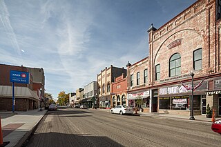
Whiteland is a town in Pleasant, Franklin and Clark townships, Johnson County, Indiana, United States. The population was 4,599 at the 2020 census.

<span class="mw-page-title-main">Highland, Lake County, Indiana</span> Town in Indiana, United States

Highland is a town in Lake County, Indiana, United States. The population was 23,984 at the 2020 census. The town was incorporated on April 4, 1910. It is a part of the Chicago metropolitan area and North Township, and is surrounded by Hammond to the north, Munster to the west, Schererville to the south and Griffith to the east.

<span class="mw-page-title-main">Pendleton, Indiana</span> Town in Indiana, United States

Pendleton is a town in Fall Creek Township, Madison County, Indiana, United States. The population was 4,717 at the 2020 census, up from 4,253 in 2010.

<span class="mw-page-title-main">Valparaiso, Indiana</span> City in Indiana, United States

Valparaiso, colloquially Valpo, is a city and the county seat of Porter County, Indiana, United States. The population was 34,151 at the 2020 census. It is part of the Chicago metropolitan area.

<span class="mw-page-title-main">Riverdale, Iowa</span> City in Iowa, United States

Riverdale is a city in Scott County, Iowa, United States. The population was 379 at the time of the 2020 census.

<span class="mw-page-title-main">Butler Township, Butler County, Pennsylvania</span> Township in Pennsylvania, United States

Butler Township is a township in Butler County, Pennsylvania, United States. The population was 17,230 at the 2020 census. The township was first settled by Europeans in 1795. It was established as a township in 1804 and as a first class township in 1922.

<span class="mw-page-title-main">Exton, Pennsylvania</span> Census-designated place in Pennsylvania, United States

Exton is a census-designated place (CDP) in West Whiteland Township in Chester County, Pennsylvania, United States. Its population was 5,622 at the 2020 census. The Exton Square Mall and Main Street at Exton are both located within Exton along with several other shopping centers, making Exton the major shopping district in Chester County.

<span class="mw-page-title-main">Antelope, California</span> Census-designated place in California, United States

Antelope is a census-designated place in Sacramento County, California, United States located approximately 15 miles (24 km) northeast of downtown Sacramento and 5 miles (8 km) southwest of Roseville. The population was 45,770 at the 2020 census.

<span class="mw-page-title-main">Indianapolis metropolitan area</span> Metropolitan area in Indiana, United States

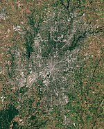
The Indianapolis metropolitan area is an 11-county metropolitan area in the U.S. state of Indiana. Its principal cities are Indianapolis, Carmel, Greenwood, and Anderson. Other primary cities with populations of more than 50,000 include Fishers, Noblesville, and Westfield. Located in Central Indiana, it is the largest metropolitan area entirely within Indiana and the seventh largest in the American Midwest.

<span class="mw-page-title-main">Brookhaven, Georgia</span> City in Georgia, United States

Brookhaven is a city in the northeastern suburbs of Atlanta that is located in western DeKalb County, Georgia, United States, directly northeast of Atlanta. On July 31, 2012, Brookhaven was approved in a referendum to become DeKalb County's 11th city. Incorporation officially took place on December 17, 2012, on which date municipal operations commenced. With a population of around 55,366 as of 2021, it is the largest city in DeKalb County. The new city stretches over 12 square miles (31 km2).

<span class="mw-page-title-main">Indiana's 6th congressional district</span> U.S. House district for Indiana

Indiana's 6th congressional district is a congressional district in the U.S. state of Indiana. The district takes in a portion of eastern and central Indiana as of the 2020 census, including Columbus and Richmond, some of Cincinnati's Indiana suburbs, most of Indianapolis' southern suburbs, and a sliver of Indianapolis itself.

<span class="mw-page-title-main">Whiteland Community High School</span> Public high school in Whiteland, Johnson County, Indiana, United States

Whiteland Community High School is a public high school located in Whiteland, Indiana. It is the only high school in continuous use in the town of Whiteland.

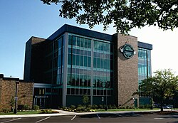
Clark-Pleasant Community School Corporation (CPCSC) is a school district headquartered in Whiteland, Indiana. It serves Whiteland, New Whiteland, portions of Greenwood, and a very small section of Franklin.

References

  1. "About the Mayor". Greenwood.gov. Greenwood City Council. Retrieved July 19, 2022.
  2. "2020 U.S. Gazetteer Files". United States Census Bureau. Retrieved March 16, 2022.
  3. 1 2 U.S. Geological Survey Geographic Names Information System: Greenwood, Indiana
  4. 1 2 "U.S. Census website". United States Census Bureau . Retrieved January 31, 2008.
  5. 1 2 "Story Map Tour" . Retrieved October 24, 2016.
  6. "History of Greenwood Timeline" . Retrieved June 8, 2020.
  7. Branigin, Elba L. (1913). History of Johnson County, Indiana. B. F. Bowen & Company. p. 531.
  8. "The Economic and Social Impact of the Electric Interurban Railways on Indianapolis: A Sketch for a Portrait" (PDF). www.indianahistory.org.
  9. "Greenwood". The Polis Center. Indiana University Purdue University Indianapolis. Retrieved September 8, 2016.
  10. "GREATER SOUTHEAST". polis.iupui.edu/. IUPUI. Retrieved January 27, 2015.
  11. Reed, Robert (March 28, 1965). "Report shows Greenwood had a 'sundown' law..." The Daily Journal . Franklin, Indiana. p. 1 via Newspapers.com. The progressive city of Greenwood is one of 19 Indiana communities that once had an unwritten 'sundown law' forbidding Negroes to be in town after dark according to the Indiana Civil Rights Commission. ... The Civil Rights Commission noted that several Negroes lived in Greenwood until the 1920s. Several were highly respected and one graduated from Greenwood high school. Since then the town has been exclusively white.
  12. "Indiana's "Sundown Ordinances" - Fact or Fiction?". Indiana Civil Rights Commission . Indianapolis, Indiana. February 1965. pp. 1, 11–12. A Study of "Sundown Ordinances" in Nineteen Indiana Towns and Cities. Greenwood Case Illustrates Housing Problem Facing Negroes.
  13. "National Register Information System". National Register of Historic Places . National Park Service. July 9, 2010.
  14. "Growing central Indiana suburbs mull class status". www.ibj.com. November 14, 2013. Retrieved August 3, 2016.
  15. Gomez, Jazlyn; Gonzalez, Lucas (July 17, 2022). "Mass shooting at Greenwood Park Mall leaves multiple dead, injured". WRTV. Retrieved July 17, 2022.
  16. "Greenwood, IN". United States Census Bureau . Retrieved March 24, 2022.
  17. "Greenwood City Maps". City of Greenwood.
  18. "Greenwood climate: Average Temperature, weather by month, Greenwood weather averages - Climate-Data.org". en.climate-data.org. Retrieved September 11, 2021.
  19. "Parks | Greenwood, IN". www.greenwood.in.gov. Retrieved May 26, 2021.
  20. "Access Johnson County" . Retrieved September 5, 2023.
  21. "IndyGo Full System Map" (PDF). Retrieved September 15, 2023.
  22. "2015 Comprehensive Annual Financial Report" (PDF). City of Greenwood.
  23. "Diverging diamond interchange in Greenwood is only the second in Indiana" . Retrieved August 5, 2016.
  24. "Census of Population and Housing". Census.gov. Retrieved June 4, 2015.
  25. "U.S. Census website". United States Census Bureau . Retrieved December 11, 2012.
  26. Aspire Johnson County. Economic Development-Demographics Report (Greenwood, Indiana), Pages 1-5. Thousand Oaks, Calif.: Applied Geographic Solutions, 2023.
  27. "Endress+Hauser inaugurates new Customer Center | Endress+Hauser". www.us.endress.com. Retrieved March 25, 2021.
  28. "Nachi History | Nachi America".
  29. "Amazon offers inside look at Greenwood facility during COVID-19 pandemic". wthr.com. May 26, 2020. Retrieved March 25, 2021.
  30. Ketterer, Emily (September 10, 2020). "Milwaukee Tool to bring 450 new jobs to Greenwood". Daily Journal.
  31. Ketterer, Emily (May 6, 2021). "Holcomb, Myers tout economic growth at Milwaukee Tool opening". Daily Journal.
  32. Brown, Alex. "Expansion Brewing in Greenwood" . Retrieved August 3, 2016.
  33. "CALLERLAB Home Office Moved to Greenwood, IN – CALLERLAB". October 18, 2022. Retrieved February 10, 2023.
  34. "High school graduate or higher, percent of persons age 25 years+, 2010–2014". www.census.gov. Retrieved July 15, 2016.
  35. "SCHOOL DISTRICT REFERENCE MAP (2010 CENSUS): Johnson County, IN." U.S. Census Bureau. Retrieved on December 5, 2016.
  36. Administrator. "Home". gws.k12.in.us. Retrieved January 27, 2015.
  37. "Clark-Pleasant Community School Corporation". www.cpcsc.k12.in.us. Retrieved July 5, 2016.
  38. "Center Grove Community School Corporation / Overview". centergrove.k12.in.us. Retrieved January 27, 2015.
  39. "Our Lady of the Greenwood Catholic School". ol-g.org. Archived from the original on January 27, 2015. Retrieved January 27, 2015.
  40. "Saints Francis: Home". ssfcschool.org. Retrieved January 27, 2015.
  41. "Greenwood Christian Academy". gcak12.org. Retrieved January 27, 2015.
  42. "Suburban Christian School". suburbanbaptist.org. Retrieved January 27, 2015.
  43. "Indiana Baptist College" . Retrieved May 21, 2021.
  44. "Indiana Tech Non-Traditional and Online" . Retrieved May 24, 2021.
  45. "Indiana Wesleyan University - GREENWOOD ED. CENTER" . Retrieved May 21, 2021.
  46. "Indiana public library directory" (PDF). Indiana State Library. Archived from the original (PDF) on February 18, 2017. Retrieved March 8, 2018.
  47. "Locations and hours". Johnson County Public Library. Retrieved March 8, 2018.