Megaregions of the United States

Last updated

Northeast megaregion (megalopolis) at night. Imagery was collected by the Suomi NPP satellite in April and October 2012, courtesy of the NASA Earth Observatory/NOAA NGDC. Northeast megalopolis at night.jpg
Northeast megaregion (megalopolis) at night. Imagery was collected by the Suomi NPP satellite in April and October 2012, courtesy of the NASA Earth Observatory/NOAA NGDC.

The megaregions of the United States are eleven regions of the United States that contain two or more roughly adjacent urban metropolitan areas that, through commonality of systems, including transportation, economies, resources, and ecologies, experience blurred boundaries between the urban centers, perceive and act as if they are a continuous urban area. [1]

Contents

Each respective region is also known as a "megalopolis", a term initially coined to define Northeastern United States, which ranges from Boston in the north to Washington, D.C. in the south. The region has an estimated population of over 50 million people as of 2022 and includes some of the nation's largest cities, including Baltimore, New York City, and Philadelphia.

Definition

In the perspective of a Texas group research group whose focus is "education, and technology transfer initiatives to improve the mobility of people and goods in urban and rural communities of megaregions," there is no single, preponderant, widely agreed upon statutory/regulatory definition of a megaregion. [2] [ better source needed ] Historically, it is the modernised term offered to the geography, urban planning, and related communities via the America 2050 [3] [1] initiative to describe a group of two or more roughly adjacent metropolitan areas that, through commonality of systems—e.g., of transport, economy, resources, and ecologies—experience a blurring of the boundaries between the population centers, such that while some degree of separation may remain, their perception as a continuous urban area, e.g., "to coordinate policy at this expanded scale", is of value. [1]

Its direct antecedent, in the same organisation and scholarship, is in the term megalopolis, which was repurposed from earlier different meanings by Jean Gottmann of the University of Paris and the Institute for Advanced Study at Princeton in the late 1950s and early 1960s. Gottmann directed "A Study of Megalopolis" for The Twentieth Century Fund, applying that term to an analysis of the urbanized northeastern seaboard of the U.S. spanning from Boston in the north to Washington, D.C. in the south and including New York City, Philadelphia, and Baltimore, which was named the Northeast megalopolis, [4] [5] which became known as the "Northeast megaregion" in the work of America 2050 [and its sponsor, the Regional Plan Association (RPA)]. [1] [3] (The RPA is an independent, New York-based, non-profit planning organization.[ citation needed ]) A reputable, broader American description from the same organisation defines a megaregion as a large network of metropolitan regions that share several or all of the following:

According to the RPA, as of this date,[ when? ] more than 70 percent of the nation's population and employment opportunities are located in the 11 U.S. megaregions they have identified.[ citation needed ] Megaregions are spoken of as becoming the new competitive units in the global economy, characterized by the increasing movement of goods, people and capital among their metropolitan regions. [3] "The New Megas," asserts Richard Florida, "are the real economic organizing units of the world, producing the bulk of its wealth, attracting a large share of its talent and generating the lion's share of innovation." [6]

Despite these scholarly perspectives, statutory and regulatory documents have not arrived at a single definition, which has led to "variations on what should be prioritized within megaregions across jurisdictions". [2] [ better source needed ] The megaregion concept provides cities and metropolitan regions a context within which to cooperate across jurisdictional borders, including the coordination of policies, to address specific challenges experienced at the megaregion scale, such as planning for high-speed rail, protecting large watersheds, and coordinating regional economic development strategies. However, megaregions are not formally recognized in the hierarchy of governance structure like a city or metropolitan planning organization (MPO). In cont, megaregions that cross international borders (such as the Southern California, Gulf Coast, and Arizona Sun Corridor megaregions), while having a shared history and culture, are often limited in power. Overall, planning in cross-jurisdictional megaregions can be susceptible to varying levels of regulations. This makes creating plans for megaregions surprisingly complex. [2] [ verification needed ]

Identified U.S. megaregions

Regional Plan Association map of the United States showing the 11 U.S. megaregions MapofEmergingUSMegaregions.png
Regional Plan Association map of the United States showing the 11 U.S. megaregions

The 11 emerging megaregions identified by the RPA are: [1] [7]

Identification

The Regional Plan Association methodology for identifying the emerging megaregions included assigning each county a point for each of the following:

Shortcomings of the RPA method

This methodology was much more successful at identifying fast-growing regions with existing metropolitan centers than more sparsely populated, slower growing regions. Nor does it include a distinct marker for connectedness between cities. [1] The RPA method omits the eastern part of the Windsor-Quebec City urban corridor in Canada.

Statistics (RPA reckoning)

Megalopolis NamePopulation
in millions
2010
Percent of U.S. Population (2010)Population
in millions
2025 (projected)
Population
percent growth 2010 - 2025 (projected)
Major cities and metro areas
Arizona Sun Corridor [13] [14] 5.62%7.839.3% Chandler, Mesa, Phoenix, Tucson, Nogales
Cascadia 12.44%13.58.2% Abbotsford, Boise**, Eugene, Portland (OR), Salem, Seattle, Tacoma, Spokane**, Tri-Cities**, Vancouver (BC), Vancouver (WA), Victoria
Florida 17.36%21.524.3% Fort Lauderdale, Jacksonville, Miami, Orlando, Port St. Lucie, Tampa Bay Area (TampaSt. PetersburgClearwater), West Palm Beach
Front Range 5.52%6.926% Albuquerque, Cheyenne, Colorado Springs, Denver, Pueblo, Salt Lake City**
Great Lakes 55.518%60.79.4% Buffalo, Chicago, Cincinnati, Cleveland, Columbus, Detroit, Erie, Fox Cities**, Grand Rapids, Hamilton, Indianapolis, Kansas City**, Louisville, Madison, Milwaukee, Minneapolis–Saint Paul**, Montreal**, Ottawa**, Pittsburgh, Quebec City**, Rochester**, Sarnia, Sault Ste. Marie**, Niagara Falls, St. Louis, Sudbury, Syracuse, Toledo, Toronto, Twin Ports**, Wheeling, Windsor
Gulf Coast 13.44%16.321.6% Baton Rouge, Beaumont–Port Arthur, Corpus Christi, Gulfport–Biloxi, Houston, Lafayette, Lake Charles, Mobile, New Orleans, Pensacola, Navarre
Northeast 52.317%58.411.7% Atlantic City, Baltimore, Boston, Brookhaven, Bridgeport, Danbury, Hampton Roads (Virginia Beach, Norfolk), Harrisburg, Hempstead, Islip, Jersey City, Lehigh Valley (Allentown-Bethlehem-Easton), Newark, New Haven, New York, Norwalk, Oyster Bay, Paterson, Philadelphia, Portland (ME), Providence, Richmond, Knowledge Corridor (Springfield and Hartford), Stamford, Trenton, Washington, Waterbury, Wilmington, Worcester, Yonkers
Northern California 145%16.417.1% Fresno, Modesto, Oakland, Reno, Sacramento, San Francisco, San Jose, Stockton, Vallejo
Piedmont Atlantic 17.66%21.723.3% Atlanta, Birmingham, Charlotte, Chattanooga, Greenville, Huntsville, Jonesboro, Knoxville**, Memphis**, Montgomery, Nashville**, Piedmont Triad (GreensboroWinston-Salem), Research Triangle (RaleighDurham-Chapel Hill), Tuscaloosa
Southern California 24.48%2918.9% Anaheim, Bakersfield, Inland Empire (San BernardinoRiverside), Las Vegas, Long Beach, Los Angeles, San Diego, Tijuana
Texas Triangle 19.76%24.825.9% Austin, Dallas–Fort Worth, Houston, Oklahoma City**, San Antonio, Tulsa**

Notes:

Major cities and areas not included by the RPA

Thirteen of the top 100 American primary census statistical areas are not included in any of the 11 emerging mega-regions. However, the Lexington-based CSA in Kentucky is identified by the RPA as being part of an "area of influence" of the Great Lakes megalopolis, while the Albany and Syracuse-based CSAs in Upstate New York are shown as being within the influence of the Northeastern mega-region. Similarly, the Augusta, GA and Columbia, SC-based CMA are considered influenced by the Piedmont-Atlantic megalopolis, Jackson, MS CMA by the Gulf Coast megaregion, Little Rock, AR CMA by the Texas Triangle, and the Des Moines and Omaha-based CMAs by the Great Lakes megalopolis. The El Paso, TX CMA is roughly equidistant from two megaregions, being near the southeastern edge of the Arizona Sun Corridor area of influence and the southern tip of the Front Range area of influence. This leaves Honolulu, HI, Wichita, KS, Springfield, MO and Charleston, SC as the only top 100 American CMAs that have no mega-region affiliation of any kind as defined by the RPA. [15]

Southwest El Paso, TX MSA (see also El Paso-Juárez)
Hawaii Honolulu, HI MSA
Kansas Wichita, KS MSA
Missouri Springfield, MO MSA
Mississippi Valley Des Moines-Newton-Pella, IA CSA, Omaha-Council Bluffs-Fremont, NE-IA CSA, Little Rock-North Little Rock-Conway, AR CSA, Jackson-Yazoo City, MS CSA, Wichita-Winfield, KS CSA
Kentucky Lexington-Fayette-Frankfort-Richmond, KY CSA
South Atlantic Coast Charleston-North Charleston-Summerville, SC MSA, Augusta-Richmond County, GA-SC MSA, Savannah, GA, Columbia, SC
Upstate New York Syracuse-Auburn, NY CSA, Albany-Schenectady-Amsterdam, NY CSA

Planning

Though identification of the megaregions has gone through several iterations, the above identified are based on a set of criteria developed by Regional Plan Association, through its America 2050 initiative - a joint venture with the Lincoln Institute of Land Policy. Two historic publications helped lay the foundation for this new set of criteria, the book Megalopolis by Jean Gottmann (1961) [16] and The Regions' Growth, part of Regional Plan Association's second regional plan[ citation needed ].

The relationships underpinning megaregions have become more pronounced over the second half of the 20th century as a result of decentralized land development, longer daily commutes, increased business travel, and a more footloose, flexible, knowledge workforce. The identification of new geographic scales—historically based on increased population movement from the city center to lower density areas as a megaregion presents immense opportunities from a regional planning perspective, to improve the environmental, infrastructure and other issues shared among the regions within it. The most recent and only previous attempt to plan at this scale happened more than 70 years ago, with the Tennessee Valley Authority. Political issues stymied further efforts at river basin planning and development. [6]

In 1961's Megalopolis, Gottman describes the Northeastern seaboard of the United States - or Megapologis - as "... difficult to single out ... from surrounding areas, for its limits cut across established historical divisions, such as New England and the Middle Atlantic states, and across political entities, since it includes some states entirely and others only partially." On the complex nature of this regional scale, he writes:

Some of the major characteristics of Megalopolis, which set it apart as a special region within the United States, are the high degree of concentration of people, things and functions crowded here, and also their variety. This kind of crowding and its significance cannot be described by simple measurements. Its various aspects will be shown on a number of maps, and if these could all be superimposed on one base map there would be demarcated an area in which so many kinds of crowding coincide in general (though not always in all the details of their geographical distribution) that the region is quite different from all neighboring regions and in fact from any other part of North America. The essential reason for its difference is the greater concentration here of a greater variety of kinds of crowding. Crowding of population, which may first be expressed in terms of densities per square mile, will, of course, be a major characteristic to survey. As this study aims at understanding the meaning of population density, we shall have to know the foundation that supports such crowding over such a very vast area. What do these people do? What is their average income and their standard of living? What is the distribution pattern of wealth and of certain more highly paid occupations? For example, the outstanding concentration of population in the City of New York and its immediate suburbs (a mass of more than ten million people by any count) cannot be separated from the enormous concentration in the same city of banking, insurance, wholesale, entertainment, and transportation activities. These various kinds of concentration have attracted a whole series of other activities, such as management of large corporations, retail business, travel agencies, advertising, legal and technical counseling offices, colleges, research organizations, and so on. Coexistence of all these facilities on an unequaled scale within the relatively small territory of New York City, and especially of its business district...has made the place even more attractive to additional banking, insurance, and mass media organizations. [16]

in the US, megaregions have been garnering more attention at the federal level. In 2016, the United States Department of Transportation (USDOT) awarded The University of Texas at Austin a five-year grant to lead a consortium under the University Transportation Centers (UTC) program, called Cooperative Mobility for Competitive Megaregions (CM2). The center aims to advance research, education, and technology transfer initiatives to improve the mobility of people and goods in urban and rural communities of megaregions. [17] In addition, the Transportation Research Board (a division of the National Research Council of the United States), listed "megaregions" in two of its "Critical Issues in Transportation 2019" Policy Snapshot reports. [18]

Outside of the United States

The RPA report identifies megaregions that are shared between the US and Canada, and is presumably at least tangentially concerned with pan-North American issues. However, being based on largely American research, it does not clearly define the geographic extent of megaregions where they extend into Canada, a responsibility that has largely been left to Canadian geographers defining the megalopolis within their own country. The American report excludes Canadian population centres that are not deemed to be closely adjacent to US megaregions. It includes most of Southern Ontario in the Great Lakes Megaregion but excludes the St. Lawrence Valley, despite the fact that Canadian geographers usually include them as part of one larger Quebec City-Windsor Corridor.

The close relationship between large linked metropolitan regions and a nation's ability to compete in the global economy is recognized in Europe and Asia. Each has aggressively pursued strategies to manage projected population growth and strengthen economic prosperity in its large regions.

The European Spatial Development Perspective, a set of policies and strategies adopted by the European Union in 1999, is working to integrate the economies of the member regions, reduce economic disparities, and increase economic competitiveness (Faludi 2002; Deas and Lord 2006).

In East Asia, comprehensive strategic planning for large regions, centered on metropolitan areas, has become increasingly common and has progressed further than in the United States or Europe. Planning for the Hong Kong-Pearl River Delta region, for instance, aims to enhance the region's economic strength and competitiveness by overcoming local fragmentation, building on global economic cooperation, taking advantage of mutually beneficial economic factors, increasing connectivity among development nodes, and pursuing other strategic directions. [6]

See also

Related Research Articles

<span class="mw-page-title-main">Conurbation</span> Group of settlements linked by continuous urban area

A conurbation is a region comprising a number of metropolises, cities, large towns, and other urban areas which, through population growth and physical expansion, have merged to form one continuous urban or industrially developed area. In most cases, a conurbation is a polycentric urbanised area in which transportation has developed to link areas. They create a single urban labour market or travel to work area.

<span class="mw-page-title-main">BosWash</span>

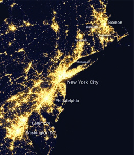
BosWash is a name coined by futurist Herman Kahn in a 1967 essay describing a theoretical United States megalopolis extending from the metropolitan area of Boston to that of Washington, D.C. The publication coined terms like BosWash, referring to predicted accretions of the Northeast, and SanSan for the urbanized region in Coastal California. The general concept for the area described by BosWash was first identified as "The Atlantic seaboard area from north of Boston to south of Washington" by French geographer Jean Gottmann in the annual report of the Twentieth Century Fund on May 25, 1958. Gottman elaborated on the 600 miles (970 km) stretch of cities in his 1961 book Megalopolis: The Urbanized Northeastern Seaboard of the United States, although the term BosWash did not appear in the work.

(Ivan) Jean Gottmann was a French geographer who was best known for his seminal study on the urban region of the Northeast megalopolis. His main contributions to human geography were in the sub-fields of urban, political, economic, historical and regional geography. His regional specializations ranged from France and the Mediterranean to the United States, Israel, and Japan.

California's major urban areas normally are thought of as two large megalopolises: one in Northern California and one in Southern California, separated from each other by approximately 382 miles or 615 km, with sparsely inhabited (relatively) Central Coast, Central Valley, and Transverse Ranges in between. Other ideas conceive of a single megalopolis encompassing both North and South, or a division of Coastal California vs. Inland California. These regional concepts are usually based on geographic, cultural, political, and environmental differences, rather than transportation and infrastructure connectivity and boundaries.

<span class="mw-page-title-main">Greater Pittsburgh</span> Region in the U.S. State of Pennsylvania

Greater Pittsburgh is the metropolitan area surrounding the city of Pittsburgh in Western Pennsylvania, United States. The region includes Allegheny County, Pittsburgh's urban core county and economic hub, and seven adjacent Pennsylvania counties: Armstrong, Beaver, Butler, Fayette, Lawrence, Washington, and Westmoreland in Western Pennsylvania, which constitutes the Pittsburgh, PA Metropolitan Statistical Area MSA as defined by the U.S. Census Bureau.

<span class="mw-page-title-main">Megalopolis</span> Grouping of neighbouring metropolises

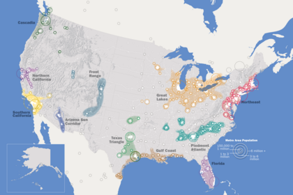
A megalopolis or a supercity, also called a megaregion, is a group of metropolitan areas which are perceived as a continuous urban area through common systems of transport, economy, resources, ecology, and so on. They are integrated enough that coordinating policy is valuable, although the constituent metropolises keep their individual identities. The megalopolis concept has become highly influential as it introduced a new, larger scale thinking about urban patterns and growth.

<span class="mw-page-title-main">Mega Manila</span> Megalopolis in the Philippines

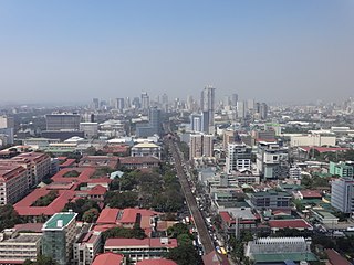
Mega Manila is a megalopolis on the island of Luzon in the Philippines. There are varying definitions of the megalopolis, but it is generally seen as encompassing the administrative regions of Central Luzon, Calabarzon, and Metro Manila. On some occasions, the administrative region of Mimaropa is also included.

<span class="mw-page-title-main">Regional Plan Association</span> Think tank in the US

The Regional Plan Association is an independent, not-for-profit regional planning organization, founded in 1922, that focuses on recommendations to improve the quality of life and economic competitiveness of a 31-county New York–New Jersey–Connecticut region in the New York metropolitan area. Headquartered in New York City, it has offices in Princeton, New Jersey, and Stamford, Connecticut.

<span class="mw-page-title-main">Southern Rocky Mountain Front</span> Megaregion of the U.S. in the United States

The Southern Rocky Mountain Front is a megaregion of the United States, otherwise known as a megalopolis, with population centers consisting mainly of the Front Range Urban Corridor and the Albuquerque–Santa Fe–Las Vegas combined statistical area, located along the eastern and southern face of the Southern Rocky Mountains in the U.S. states of Wyoming, Colorado, and New Mexico. The region comprises the southern portion of the Rocky Mountain Front geographic region of Canada and the United States, extending into the Southwestern United States. The Southern Rocky Mountain Front had a population of 5,467,633 according to the 2010 United States census. The region is one of the fastest-growing regions in the United States, and its population is projected to grow by 87% to 10,222,370 by 2050. In 2005 the GDP of the region was $229,202,000,000 making up 2% of the United States GDP.

<span class="mw-page-title-main">Metropolitan areas of Mexico</span> List of biggest metropolitan areas in Mexico

Metropolitan areas of Mexico have been traditionally defined as the group of municipalities that heavily interact with each other, usually around a core city, in Mexico. The phenomenon of metropolization in Mexico is relatively recent, starting in the 1940s. Because of an accelerated level of urbanization in the country, the definition of a metropolitan area is reviewed periodically by the Mexican population and census authorities.

<span class="mw-page-title-main">Piedmont Crescent</span> Region in the U.S. state of North Carolina

The Piedmont Crescent, also known as the Piedmont Urban Crescent, is a large, polycentric urbanized region in the U.S. state of North Carolina that forms the northern section of the rapidly developing Piedmont Atlantic megalopolis, a conurbation also known as the "I-85 Boombelt", which extends from the Raleigh area in North Carolina, southwards to Atlanta, Georgia in the southeastern United States.

<span class="mw-page-title-main">Northeast megalopolis</span> Megaregion of the U.S.

The Northeast megalopolis, also known as the Northeast Corridor, Acela Corridor, Boston–Washington corridor, BosWash, or BosNYWash, is the world's largest megalopolis by economic output and the second-most populous megalopolis in the United States with about 50 million residents as of 2022.

<span class="mw-page-title-main">Great Lakes megalopolis</span> Cities around the Great Lakes of North America

The Great Lakes megalopolis consists of a bi-national group of metropolitan areas in North America largely in the Great Lakes region. It extends from the Midwestern United States in the south and west to western Pennsylvania and Western New York in the east and northward through Southern Ontario into southwestern Quebec in Canada. It is the most populated and largest megalopolis in North America.

<span class="mw-page-title-main">Piedmont Atlantic megaregion</span> Megaregion of the southeastern USA

The Piedmont Atlantic megaregion is a neologism created by the Regional Plan Association for an area of the Southeastern United States that contains parts of the states of Alabama, Georgia, Tennessee, South Carolina, and North Carolina. The region includes the Atlanta, Birmingham, Charlotte, Memphis, Nashville, Research Triangle (Raleigh-Durham), and Greensboro-Winston-Salem-High Point metropolitan areas. The megaregion generally follows the Interstate 85/20 corridor. According to Georgia Tech, the Piedmont Atlantic represents over 12 percent of the total United States population and covers over 243,000 square miles (630,000 km2) of land.

<span class="mw-page-title-main">Texas Triangle</span> Region of Texas that contains the states five largest cities

The Texas Triangle is a region of Texas that contains the state's five largest cities and is home to the majority of the state's population. The Texas Triangle is formed by the state's four main urban centers, Austin, Dallas-Fort Worth, Houston, and San Antonio, connected by Interstate 45, Interstate 10, and Interstate 35. In 2020, the population of the Texas Triangle reached nearly 21 million following rapid growth across much of Texas. The Texas Triangle is one of eleven megaregions in the United States, clusters of urban areas that share economic and cultural ties.

<span class="mw-page-title-main">Arizona Sun Corridor</span> Megaregion in Arizona, United States

The Arizona Sun Corridor, shortened Sun Corridor, is a megaregion, or megapolitan area, in the southern area of the U.S. state of Arizona. The Sun Corridor is comparable to Indiana in both size and population. It is one of the fastest growing conurbations in the country and is speculated to double its population by 2040. The largest metropolitan areas are the Phoenix metropolitan area – Valley of the Sun, and the Tucson metropolitan area – The Old Pueblo. The regions' populace is nestled in the valley of a desert environment. Similar to Southern California, the urban area extends into Mexico, reaching the communities of Heroica Nogales and Agua Prieta.

<span class="mw-page-title-main">Front Range urban corridor</span> Megaregion in Colorado and Wyoming, United States

The Front Range Urban Corridor is an oblong region of urban population located along the eastern face of the Southern Rocky Mountains, encompassing 18 counties in the US states of Colorado and Wyoming. The corridor derives its name from the Front Range, the mountain range that defines the western boundary of the corridor which serves as a gateway to the Rocky Mountains. The region comprises the northern portion of the Southern Rocky Mountain Front geographic area, which in turn comprises the southern portion of the Rocky Mountain Front geographic area of Canada and the United States. The Front Range Urban Corridor had a population of 5,055,344 at the 2020 Census, an increase of +16.65% since the 2010 Census.

An industrial corridor is a package of infrastructure spending allocated to a specific geographical area, with the intent to stimulate industrial development.

<span class="mw-page-title-main">Northern California megaregion</span> Megaregion of the U.S. in California

The Northern California megaregion, distinct from Northern California, is an urbanized region of California consisting of many large cities including San Jose, San Francisco, Sacramento, and Oakland. There are varying definitions of the megaregion, but it is generally seen as encompassing the San Francisco Bay Area, the Sacramento area, northern San Joaquin Valley, and the Monterey Bay Area.

References

  1. 1 2 3 4 5 6 7 Hagler, Yoav (November 2009). "Defining U.S. Megaregions" (PDF). America 2050 . Retrieved February 19, 2022 via RPA.org. As metropolitan regions continued to expand throughout the second half of the 20th century their boundaries began to blur, creating a new scale of geography now known as the megaregion. Interlocking economic systems, shared natural resources and ecosystems, and common transportation systems link these... The challenge of identifying... emerging regions has been undertaken... The most recent iteration... has been developed by Regional Plan Association (RPA) in partnership with the Lincoln Institute of Land Policy. Eleven such megaregions have been identified... that would make cooperative integrated planning advantageous... Th[e] tradition of geographers and planners attempting to enhance the value of geographic definitions to meet the needs of new generations continued with the first identification of a scale larger than the metro regions by French geographer Jean Gottmann in his 1961 book Megalopolis. This "Megalopolis" referred specifically to the Northeastern United States ... Regional Plan Association also identified this emerging Northeast Megaregion in the 1960s.
  2. 1 2 3 Posner, Olivia (January 2019) [Unknown]. "What are Megaregions?" (university research perspective). UTexas.edu. Austin, Tex.: Cooperative Mobility for Competitive Megaregions (CM2) [multiuniversity consortium]. Retrieved February 19, 2019. ...there is no single definition of a megaregion. Lisa Loftus-Otway, research associate... and her team at UT Austin observed this... Because the term has been defined differently, there are variations on what should be prioritized within megaregions across jurisdictions... planning in cross-jurisdictional megaregions can be susceptible to varying levels of regulations. This makes creating plans for megaregions surprisingly complex.
  3. 1 2 3 4 Regional Plan Association (2006). America 2050: A Prospectus. New York, NY: Regional Plan Association.[ full citation needed ]
  4. Gottmann, Jean (1957). "Megalopolis, or the urbanization of the Northeastern Seaboard". Economic Geography. 33 (3): 189–200. doi:10.2307/142307. JSTOR   142307.
  5. Gottmann, Jean (1961). Megalopolis: The Urbanized Northeastern Seaboard of the United States . New York, N.Y.: The Twentieth Century Fund. See also Gottmann, Jean (1954). L'Amerique. Paris, France: Hachette.[ clarification needed ]
  6. 1 2 3 Dewar, Margaret and David Epstein (2006). "Planning for 'Megaregions' in the United States". Ann Arbor, MI: Urban and Regional Planning Program, University of Michigan.
  7. Kron, Josh (November 30, 2012). "Red State, Blue City: How the Urban-Rural Divide Is Splitting America". The Atlantic. Retrieved April 10, 2015.
  8. Abbott, Carl (2015). "Cascadian Dreams: Imagining a Region Over Four Decades". Imagined Frontiers: Contemporary America and Beyond. University of Oklahoma Press. pp. 111–139. ISBN   978-0-8061-5240-0.
  9. 1 2 "Defining U.S. Megaregions" (PDF). S3.us-east-1.amazonaws.com. Retrieved July 25, 2022.
  10. Bonneville Power Administration and States of the Pacific Northwest: Hearing Before the Subcommittee on Separation of Powers of the Committee on the Judiciary, United States Senate, Ninety-seventh Congress, Second Session, on Bonneville Power Administration and States of the Pacific Northwest, Held at Helena, Montana, August 31, 1982. U.S. Government Printing Office. 1983.
  11. Mushrooms of the Pacific Northwest. Timber Press. September 2009. ISBN   9781604691412.
  12. Weitz, Jerry (2014). Employment Changes in the Spine of the Carolina Megapolitan Area: Implications for Megaregion Planning. Vol. 54. pp. 215–232. doi:10.1353/sgo.2014.0026. ISBN   9781469616032. ISSN   1549-6929. S2CID   129370807.{{cite book}}: |journal= ignored (help)
  13. "Megapolitan: Arizona's Sun Corridor". Morrison Institute for Public Policy. May 2008. Archived from the original on June 15, 2008. Retrieved June 3, 2008.
  14. "When Phoenix, Tucson Merge". The Arizona Republic. April 9, 2006. Retrieved June 3, 2008.
  15. "Our Maps". America2050. USA: Regional Plan Association. Retrieved October 1, 2014.
  16. 1 2 Gottman, Jean (1961). Megalopolis: The Urbanized Northeastern Seaboard of the United States. New York: Twentieth Century Fund.
  17. "Mission & Objectives". sites.utexas.edu. Retrieved January 28, 2019.
  18. "Critical Issues in Transportation 2019: Policy Snapshot | The National Academies Press". www.nap.edu. Retrieved January 28, 2019.

Further reading