Arizona Sun Corridor

Last updated
Arizona Sun Corridor
Phoenix skyline.jpg
Tucson asr.JPG
Mesa City Hall.jpg
Counter-clockwise from top: downtown Phoenix skyline, downtown Tucson, Mesa City Hall
USA Arizona location map.svg
Red pog.svg
Phoenix
Red pog.svg
Tucson
Red pog.svg
Sierra Vista
Red pog.svg
Casa Grande
Red pog.svg
Nogales
Red pog.svg
Prescott
Selected cities of the Arizona Sun Corridor
Coordinates: 33°N112°W / 33°N 112°W / 33; -112
CountryUS
StateArizona
Population
 (2010)
  Total5,517,131
  Rank 10th
  2040 Projection
10,100,000
  [1]

The Arizona Sun Corridor, shortened Sun Corridor, is a megaregion, or megapolitan area, in the southern area of the U.S. state of Arizona. The Sun Corridor is comparable to Indiana in both size and population. It is one of the fastest growing conurbations in the country and is speculated to double its population by 2040. [2] The largest metropolitan areas are the Phoenix metropolitan area – Valley of the Sun, and the Tucson metropolitan area – The Old Pueblo. The regions' populace is nestled in the valley of a desert environment. [2] Similar to Southern California, the urban area extends into Mexico, reaching the communities of Heroica Nogales and Agua Prieta. [2]

Contents

Its population is composed of five metropolitan areas: Phoenix, Tucson, Prescott, Sierra Vista-Douglas [3] and Nogales. Of these, two are metropolitan areas with over 1,000,000 residents: the Phoenix metropolitan area with 4.85 million residents and the Tucson metropolitan area with over 1 million residents. The Arizona Sun Corridor is made up of all of Maricopa, Pinal and Pima counties, along with parts of Yavapai, Santa Cruz and Cochise counties. [4] It is home to over 86 percent of Arizona's population.

Most of the Arizona Sun Corridor is in the Sonoran Desert. To the south of the region is the border between the United States and Mexico, and to the north and east is the Arizona transition zone and the Mountains of Arizona. The Southern California Megaregion is to the west and is the nearest other Megaregion to the Arizona Sun Corridor.

Extent

The Arizona Sun Corridor lies in the American Southwest. MapofEmergingUSMegaregions.png
The Arizona Sun Corridor lies in the American Southwest.
Map of the Arizona Sun Corridor, showing each county in the Sun Corridor, as well as their cities, towns, and CDPs. The largest community in each county is highlighted in red. Arizona Sun Corridor with largest communities in each county highlighted.png
Map of the Arizona Sun Corridor, showing each county in the Sun Corridor, as well as their cities, towns, and CDPs. The largest community in each county is highlighted in red.

The Arizona Sun Corridor lies in the American Southwest, about halfway between the Southern California and Front Range Megaregions. It is shown on the map in deep blue.

Below is a table listing all communities of the Arizona Sun Corridor with a population of at least 10,000 residents.

NameType [5] County Population
(2010) [6]
Area (2010) [7] Population density (2010) [7]
sq mikm2/sq mi/km2
Anthem CDPMaricopa21,700
Apache Junction CityPinal35,84035.090.61,024.2395.4
Arizona City CDPPinal10,475
Avondale CityMaricopa76,23845.7118.41,672.0645.6
Buckeye CityMaricopa50,876375.4972.3135.652.4
Camp Verde TownYavapai10,87343.2111.9252.097.3
Casa Grande CityPinal48,571109.7284.1442.9171.0
Casas Adobes CDPPima66,795
Catalina Foothills CDPPima50,796
Chandler CityMaricopa236,12364.5167.13,665.81,415.4
Chino Valley TownYavapai10,81763.4164.2170.765.9
Coolidge CityPinal11,82556.6146.6209.380.8
Cottonwood CityYavapai11,26516.442.5686.5265.1
Douglas CityCochise17,37810.025.91,741.0672.2
Drexel Heights CDPPima27,749
El Mirage CityMaricopa31,79710.126.23,170.71,224.2
Eloy CityPinal16,631111.6289.0149.157.6
Flagstaff CityCoconino65,87066.1171.21,136.5438.8
Florence TownPinal25,53652.5136.0486.9188.0
Flowing Wells CDPPima16,419
Fountain Hills TownMaricopa22,48920.452.81,106.2427.1
Gilbert TownMaricopa208,45368.2176.63,067.21,184.3
Glendale CityMaricopa226,72160.1155.73,780.21,459.5
Gold Canyon CDPPinal10,159
Goodyear CityMaricopa65,275191.5496.0340.9131.6
Green Valley CDPPima21,391
Marana TownPima34,961122.2316.5287.8111.1
Maricopa CityPinal43,48247.6123.3916.0353.7
Mesa CityMaricopa439,041137.1355.13,217.51,242.3
New River CDPMaricopa14,952
Nogales CitySanta Cruz20,83720.853.91,001.0386.5
Oro Valley TownPima41,01135.692.21,154.3445.7
Paradise Valley TownMaricopa12,82015.540.1830.9320.8
Peoria CityMaricopa154,065178.0461.0883.4341.1
Phoenix CityMaricopa1,445,632518.01,341.62,797.81,080.2
Prescott CityYavapai39,84341.6107.7963.8372.1
Prescott Valley TownYavapai38,82238.7100.21,004.4387.8
Queen Creek TownMaricopa26,36128.172.8940.1363.0
Rio Rico CDPSanta Cruz18,962
San Tan Valley CDPPinal81,321
Sahuarita TownPima25,25931.080.3813.8314.2
Scottsdale CityMaricopa217,385184.4477.61,182.0456.4
Sedona CityYavapai10,03119.249.7524.1202.4
Sierra Vista CityCochise43,888152.5395.0288.2111.3
Sierra Vista Southeast CDPCochise14,797
Sun City CDPMaricopa37,499
Sun City West CDPMaricopa24,535
Sun Lakes CDPMaricopa13,975
Surprise CityMaricopa117,517105.9274.31,111.3429.1
Tanque Verde CDPPima16,901
Tempe CityMaricopa161,71940.2104.14,050.11,563.8
Tucson CityPima520,116227.0587.92,294.2885.8
Tucson Estates CDPPima12,192
Vail CDPPima10,208
Verde Village CDPYavapai11,605

Transportation

Road

Intercity in the region is provided by the I-8, I-10, I-17, and I-19 freeways, as well as US 60, SR 87, SR 90, and SR 77, among other surface highways.

Phoenix area arterials are set up in a grid pattern, which helps simplify transportation within the region. Tucson's streets have a similar system.

Rail

Amtrak's Sunset Limited operates three times a week, connecting Maricopa, Arizona and Tucson. There is no other intercity rail in the region; however Phoenix–Tucson passenger rail is in the planning phase. [8]

Intracity rail systems include the Valley Metro Rail, which operates within the Phoenix metropolitan area, connecting Uptown and Downtown Phoenix with Tempe and Mesa, and Tucson's Sun Link streetcar system, which links Downtown Tucson and the Mercado district to the University of Arizona.

Air

Phoenix Sky Harbor International Airport and Tucson International Airport provide air transportation to the region, from both within the country and from a few foreign countries, among other smaller airports, which focus on regional air traffic from nearby. Recently, Phoenix-Mesa Gateway Airport, previously being a military base, has also become an option for low-cost carriers to fly into the Phoenix area as well.

US Airways, now owned by Fort Worth company American Airlines, was once headquartered and based in Tempe after a reverse-merger from America West Airlines in 2005, headquarters of which is in the Phoenix Valley. However, American Airlines maintains a strong presence in the state due to the history with US Airways.

Related Research Articles

<span class="mw-page-title-main">Phoenix, Arizona</span> Capital of Arizona, United States

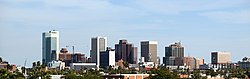
Phoenix is the capital and most populous city of the U.S. state of Arizona, with 1,608,139 residents as of 2020. It is the fifth-most populous city in the United States and the most populous state capital in the country.

<span class="mw-page-title-main">Maricopa County, Arizona</span> County in Arizona, United States

Maricopa County is in the south-central part of the U.S. state of Arizona. As of the 2020 census the population was 4,420,568, or about 62% of the state's total, making it the fourth-most populous county in the United States and the most populous county in Arizona, and making Arizona one of the nation's most centralized states. The county seat is Phoenix, the state capital and fifth-most populous city in the United States.

<span class="mw-page-title-main">Tempe, Arizona</span> City in Arizona, United States

Tempe is a city in Maricopa County, Arizona, United States, with the Census Bureau reporting a 2020 population of 180,587. The city is named after the Vale of Tempe in Greece. Tempe is located in the East Valley section of metropolitan Phoenix; it is bordered by Phoenix and Guadalupe on the west, Scottsdale and the Salt River Pima–Maricopa Indian Community on the north, Chandler on the south, and Mesa on the east. Tempe is also the location of the main campus of Arizona State University.

<span class="mw-page-title-main">Phoenix metropolitan area</span> Metropolitan Statistical Area in Arizona, United States

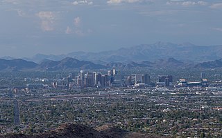
The Phoenix metropolitan area, also known as the Valley of the Sun, the Salt River Valley, metro Phoenix, or The Valley, is the largest metropolitan statistical area in the Southwestern United States, with its largest principal city being the city of Phoenix. It includes much of central Arizona. The United States Office of Management and Budget designates the area as the Phoenix–Mesa–Chandler Metropolitan Statistical Area (MSA), defining it as Maricopa and Pinal counties. It anchors the Arizona Sun Corridor megaregion along with the second-most populous metropolitan area in the state, the Tucson metropolitan area. The gross domestic product of the Phoenix metropolitan area was $255 billion in 2018, 16th highest amongst metro areas in the United States.

<span class="mw-page-title-main">Southern Arizona</span> Region of Arizona, United States

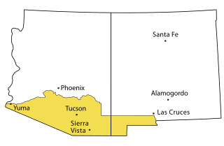
Southern Arizona is a region of the United States comprising the southernmost portion of the State of Arizona. It sometimes goes by the name Gadsden or Baja Arizona, which means "Lower Arizona" in Spanish.

The Valley Metro Regional Public Transportation Authority, more popularly known as Valley Metro, is the unified public brand of the regional transit system for the Phoenix metropolitan area. Within the system, it is divided between Valley Metro Bus, which runs all bus operations, Valley Metro Rail, which is responsible for light rail and streetcar operations in the Valley. In 2023, the combined bus and rail system had a ridership of 36,374,000, or about 122,500 per weekday as of the fourth quarter of 2023.

<span class="mw-page-title-main">Interstate 10 in Arizona</span> Interstate highway in Arizona

In the U.S. state of Arizona, Interstate 10 (I‑10), the major east–west Interstate Highway in the United States Sun Belt, runs east from California, enters Arizona near the town of Ehrenberg and continues through Phoenix and Tucson and exits at the border with New Mexico near San Simon. The highway also runs through the cities of Casa Grande, Eloy, and Marana. Segments of the highway are referred to as either the Papago Freeway, Inner Loop, or Maricopa Freeway within the Phoenix area and the Pearl Harbor Memorial Highway outside metro Phoenix.

<span class="mw-page-title-main">Arizona State Route 153</span> Former state highway in Arizona

State Route 153, also known as SR 153 and the Sky Harbor Expressway, is a former state highway in Maricopa County, in the U.S. state of Arizona, that ran from the intersection of 44th Street and Washington Street in Phoenix south to University Drive. It was a controlled access arterial expressway, with a speed limit of 45 mph (72 km/h), lower than the standard freeway speed of 65 mph (105 km/h). Route 153 was a north–south route that skirted the eastern edge of Sky Harbor International Airport, and along with SR 143, SR 153 served a portion of East Valley residents with access to the airport. Many motorists used SR 143 instead, because of its quick access to and from Interstate 10 and Loop 202. The freeway did, however, provide a direct link to office developments in the Southbank commercial project in east Phoenix with the city of Tempe.

<span class="mw-page-title-main">Tempe station (Arizona)</span> Amtrak station in Tempe, Arizona

Tempe station is a former train station in Tempe, Arizona. Previously, Amtrak's Sunset Limited and Texas Eagle trains stopped at the station, but they were shifted to a more southerly route in June 1996. However, an Amtrak Thruway shuttle route connects the station to the Maricopa station on the new routing.

The transportation system of Arizona comprises car, rail, air, bus, and bicycle transport.

The metropolitan area of Phoenix in the U.S. state of Arizona contains one of the nation's largest and fastest-growing freeway systems, with over 1,405 lane miles (2,261 km) as of 2005.

Transportation in Phoenix, Arizona is primarily via private cars. Public transport is run under the brand Valley Metro, and consists of buses, light rail, and a streetcar system.

<span class="mw-page-title-main">Arizona</span> U.S. state

Arizona is a landlocked state in the Southwestern region of the United States. Arizona is part of the Four Corners region with Utah to the north, Colorado to the northeast, and New Mexico to the east; its other neighboring states are Nevada to the northwest, California to the west and the Mexican states of Sonora and Baja California to the south and southwest. It is the 6th-largest and the 14th-most-populous of the 50 states. Its capital and largest city is Phoenix.

<span class="mw-page-title-main">Megaregions of the United States</span>

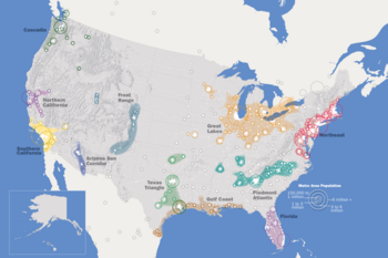
The megaregions of the United States are eleven regions of the United States that contain two or more roughly adjacent urban metropolitan areas that, through commonality of systems, including transportation, economies, resources, and ecologies, experience blurred boundaries between the urban centers, perceive and act as if they are a continuous urban area.

Many arterial roads in the Phoenix metropolitan area have the same name in multiple cities or towns. Some roads change names or route numbers across town borders, resulting in occasional confusion. For example, the road known as Apache Boulevard in Tempe continues east as Main Street in neighboring Mesa and then as Apache Trail in Apache Junction. Although Broadway Road maintains the same name through Goodyear, Avondale, Phoenix, Tempe, Mesa, and Apache Junction, each town uses a different reference point for address numbers.

The East Valley Partnership is a regional coalition of community, business, educational and government leaders whose goal is to provide leadership and support in specific areas of focus, thereby improving business and quality of life in the region.

The following is a timeline of the history of the city of Phoenix, Arizona, United States.

<span class="mw-page-title-main">Timeline of Arizona</span> Timeline of the history of Arizona

The following is a timeline of the history of the area which today comprises the U.S. state of Arizona. Situated in the desert southwest, for millennia the area was home to a series of Pre-Columbian peoples. By 1 AD, the dominant groups in the area were the Hohokam, the Mogollon, and the Ancestral Puebloans. The Hohokam dominated the center of the area which is now Arizona, the Mogollon the southeast, and the Puebloans the north and northeast. As these cultures disappeared between 1000 and 1400 AD, other Indian groups settled in Arizona. These tribes included the Navajo, Apache, Southern Paiute, Hopi, Yavapai, Akimel O'odham, and the Tohono O'odham.

There have been various proposals to bring commuter rail service to the Phoenix metropolitan area since at least the 1980s. A 2008 government plan, updated in 2018, proposes four lines running at 30-minute headways during peak hours and 2-hour headways during off-peak hours.

<span class="mw-page-title-main">Northern California megaregion</span> Megaregion of the U.S. in California

The Northern California megaregion, distinct from Northern California, is an urbanized region of California consisting of many large cities including San Jose, San Francisco, Sacramento, and Oakland. There are varying definitions of the megaregion, but it is generally seen as encompassing the San Francisco Bay Area, the Sacramento area, northern San Joaquin Valley, and the Monterey Bay Area.

References

  1. Patton, Willian; Vest, Marshall. "Sun Corridor Projections Final Report: Economic and Demographic Forecasts to 2040" (PDF). Retrieved 8 January 2023.
  2. 1 2 3 "Arizona Sun Corridor". America 2050. Archived from the original on April 28, 2020. Retrieved March 21, 2011.
  3. Arizona Has a New Metropolitan Area: Sierra Vista-Douglas 1-14-14.
  4. "Maps – America2050". America 2050. Archived from the original on May 7, 2020. Retrieved March 20, 2011.
  5. "About the League: Member Cities and Towns". Arizona League of Cities and Towns. Archived from the original on 2012-02-14. Retrieved 2009-08-09.
  6. "Annual Estimates of the Population for Incorporated Places in Arizona". United States Census Bureau. 2009-07-07. Archived from the original on 2009-07-10. Retrieved 2009-07-21.
  7. 1 2 "Population, Housing Units, Area, and Density: 2010 – State – Place, 2010 Census Summary File 1". United States Census Bureau. Archived from the original on 2020-02-12. Retrieved 2012-05-02.
  8. "Passenger Rail Study: Tucson to Phoenix". azdot.gov. Arizona Department of Transportation. Retrieved 8 January 2023.