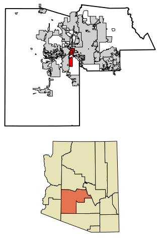
Maricopa is a city in the Gila River Valley in Pinal County, Arizona, United States. With 66,290 residents as of 2022, Maricopa is the largest incorporated municipality in Pinal County.[3]
Maricopa has had three locations over the years: Maricopa Wells, Maricopaville and Maricopa Junction; the latter gradually became known as Maricopa. It started as an oasis around a series of watering holes eight miles north of present-day Maricopa, and about a mile west of Pima Butte. European-American traders and travelers called it Maricopa Wells. Several of Arizona's rivers, the Gila, Santa Cruz, Vekol and Santa Rosa provided this oasis in the desert with an ample supply of water during this period of time.
During the late 1800s, Maricopa Wells was one of the most important relay stations along the San Antonio-San Diego Mail Line and the later more famous Butterfield Overland Mail Route. Today, very little remains of this once bustling community, but it played an important part in the progress and development of the Southwest. It was one of the best-known spots in Arizona during this period of time because it had a reliable source of water, and offered an abundant supply of food. The peaceful Pima and Maricopa farmers who lived and farmed nearby sold supplies to travelers and migrants.
The most prosperous period of time for Maricopa Wells was in the 1870s. During this time the trading center at the Wells provided water and food for not only the east–west travelers, but those who traveled to the north to Phoenix. Fairly good roads had been built by James A. Moore, the proprietor at Maricopa Wells, to all points north, and the Wells was a constant hubbub of activity.
Maricopaville developed south and west of the Wells, following construction of a railroad line from this terminus to Phoenix. In 1879, the Southern Pacific Railroad was in the process of building a railroad line from Yuma to Tucson, and a second railroad line was to be built from Maricopaville, wrapping around the western edge of South Mountain into Phoenix. With the railroad, Maricopaville took on the appearance of a gold rush California boom town, as men worked day and night building hotels, saloons, warehouses, restaurants, theaters, etc. One local newspaper at the time reckoned that with its thousands of people and good location, Maricopaville would be an ideal choice for the location of the state capital.
But the railroad never built the anticipated line from Maricopaville into Phoenix. Tempe also wanted to be on the railroad line and lobbied the territorial government to gain a stop. Officials agreed. The settlement known as Maricopaville was essentially rebuilt three miles to the east (to the present location of Maricopa) in the early 1880s, in order to accommodate the Maricopa & Phoenix line, planned to go through Kyrene and Tempe to the north on the way to Phoenix. The first train departed from Maricopa for Phoenix on July 4, 1887. All east–west rail travelers had to stop at Maricopa, and those who wanted to go north had to shift to the M & P Railroad.[4][5][6]
Maricopa was officially incorporated as a city on October 15, 2003, becoming the 88th incorporated municipality in Arizona. Between 2000 and 2010, the city's population grew from 1,040 residents to 43,482, an increase of 4080%.[7] In 2018, estimates approved by the US Census Bureau and Arizona State Demographer's Office put Maricopa's population at 51,977 pushing the city over the 50,000 mark for the first time.[8] Furthermore, data released from the official 2020 Census in August 2021 put Maricopa at 58,125, surpassing Casa Grande to become the most populous incorporated place in Pinal County and second most populous place in the county overall, behind the unincorporated San Tan Valley.[3] Population of Maricopa has continued to grow, reaching 66,290 residents as of 2022; a 6.2% increase from 2021, making Maricopa the 12th fastest growing municipality in the United States and second fastest growing in Arizona (behind Queen Creek, which is partially in Pinal County).[9]
A part of the city is within the boundaries of the Ak-Chin Indian Community. The small, federally recognized tribe has developed Harrah's Ak-Chin Casino and related resort, a multi-entertainment cinema complex, and operates a golf course; all are open to the public and draw attendees from Maricopa as well as the greater Phoenix area. In addition the tribe operates the Ak-Chin Regional Airport and an industrial park. A 2011 study said that its casino and resort made up a large part of the economy of Pinal County, in terms of number of jobs and revenue generated.[citation needed]
As of the census of 2010, there were 43,482 people, 14,359 households, and 11,110 families residing in the city. The population density was 1,356.8 inhabitants per square mile (523.9/km2). There were 17,240 housing units at an average density of 540.4 per square mile (208.6/km2). The racial makeup of the city was 70.2% White, 9.7% Black or African American, 2.0% Native American, 4.1% Asian, 0.3% Pacific Islander, 8.5% from other races, and 5.3% from two or more races. 24.4% of the population is Hispanic or Latino of any race.
There were 14,359 households, out of which 47.1% had children under the age of 18 living with them, 37.5% were married couples living together, 10.9% had a female householder with no husband present, and 22.6% were non-families. 15.6% of all households were made up of individuals, and 2.5% had someone living alone who was 65 years of age or older. The average household size was 3.03 and the average family size was 3.38.[14]
In the city, the population was spread out, with 32.5% under the age of 18, 6.2% from 18 to 24, 35% from 25 to 44, 19.8% from 45 to 64, and 6.5% who were 65 years of age or older. The median age was 31.2 years. For every 100 females, there were 98.5 males. For every 100 females age 18 and over, there were 94.8 males.
According to 2009 Census Bureau estimates, the median income for a household in the city was $67,692, and the median income for a family was $69,818. The per capita income for the city was $27,618. About 3.7% of families and 5.2% of the population were below the poverty line.
Infrastructure
Roads
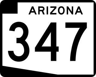
Maricopa is primarily served by Arizona State Route 347, a north–south highway that connects to Interstate 10, approximately 14 miles north of Maricopa, as well as Arizona State Route 84 11 miles south of Maricopa. State Route 84 then ends at Interstate 8 approximately 6 miles west of State Route 347. Within Maricopa, State Route 347 is John Wayne Parkway. As it leaves the city for the Gila River Indian Community to the north or the Ak-Chin Indian Community to the south, the road changes names to Maricopa Road. A portion of old State Route 347 within Maricopa also exists as Maricopa Road.[15]
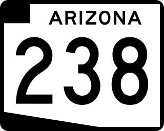
Maricopa is also served by Arizona State Route 238, which connects Maricopa to the town of Mobile, which is incorporated into the city of Goodyear. Past Mobile, State Route 238 becomes a county route that connects to Arizona State Route 85 in Gila Bend. State Route 238 and Mobile Road designations are used interchangeably. State Route 238 ends at State Route 347, and continues east as Smith-Enke Road, a major east–west corridor for the city of Maricopa. Maricopa-Casa Grande Highway also makes up a major corridor for the city, connecting it to the city of Casa Grande. This road parallels the Union Pacific Railroad at a diagonal, ultimately becoming Plainview Street within Maricopa and Cottonwood Lane in Casa Grande.
Rail
California Zephyr railcar at the Maricopa, AZ Amtrak station
Maricopa is located on a Union Pacific Railroad line. The city is currently the closest stop to Phoenix served by Amtrak's Sunset Limited and Texas Eagle trains. Maricopa station opened in 2001, originally in a converted passenger rail car but now in a metal building. Amtrak Thruway offers connecting service between Maricopa and Phoenix.
Utilities
Maricopa is served by the following utilities:[16]
Water: Global Water (Santa Cruz Water Company, Palo Verde Utilities), Maricopa Domestic Water Improvement District
Bus
The City of Maricopa operates Maricopa Express Transit (MET), which provides local bus service.[17]
Municipal organization
Maricopa is governed by a Council-Manager form of government. This type of government structure combines the political leadership of elected officials with the managerial experience of an appointed professional manager. The City Council and City Manager work as partners to direct and guide local government.
The Maricopa City Council consists of the Mayor and six City Council members. The Mayor is elected to serve a four-year term and the City Council members are elected to serve four-year terms on a rotating basis. City Council meetings are held on the first and third Tuesdays of the month.
There are 10 citizen advisory groups that guide the Maricopa City Council on a myriad of activity. They are the Board of Adjustment, Heritage District Advisory Committee, Industrial Development Authority Board, Merit Board, Parks, Recreation and Library Advisory Committee, Planning and Zoning Commission, Public Safety Personnel Retirement System Board, Transportation Advisory Committee and the Youth Council. Selection to these groups is by City Council action.
The city is organized into nine departments: the City Manager's Office, the City Clerk's Office, Community Services, Development Services, Economic Development, Finance, Fire, Human Services and the Police Department. More than 250 individuals work for the municipality.[citation needed]
Maricopa County is in the south-central part of the U.S. state of Arizona. As of the 2020 census the population was 4,420,568, or about 62% of the state's total, making it the fourth-most populous county in the United States and the most populous county in Arizona, and making Arizona one of the nation's most centralized states. The county seat is Phoenix, the state capital and fifth-most populous city in the United States.
Pima County is a county in the south central region of the U.S. state of Arizona. As of the 2020 census, the population was 1,043,433, making it Arizona's second-most populous county. The county seat is Tucson, where most of the population is centered. The county is named after the Pima Native Americans, also known as Tohono O'odham, who are indigenous to this area.
Pinal County is in the central part of the U.S. state of Arizona. According to the 2020 census, the population of the county was 425,264, making it Arizona's third-most populous county. The county seat is Florence. The county was founded in 1875.
Pima is a town in Graham County, Arizona, United States. As of the 2010 census, the population of the town was 2,387, up from 1,989 in 2000. The estimated population in 2018 was 2,512. Pima is part of the Safford Micropolitan Statistical Area.
Avondale is a city in Maricopa County, Arizona, United States, adjacent to Phoenix. As of the 2020 census, the population of the city was 89,334, up from 76,238 in 2010 and 35,883 in 2000.
Buckeye is a city in Maricopa County, Arizona, United States. It is Arizona's largest city by area, and it is the westernmost suburb in the Phoenix Metropolitan Area. As of the 2020 census, the population was 91,502, up from 50,876 in 2010, and 6,537 in 2000. It was the fastest-growing city in the United States for 2017, 2018, and 2021.
Gila Bend, founded in 1872, is a town in Maricopa County, Arizona, United States. The town is named for an approximately 90-degree bend in the Gila River, which is near the community's current location. As of the 2020 census, the population of the town was 1,892.
Goodyear is a city in Maricopa County, Arizona, United States. It is a suburb of Phoenix and at the 2020 census had a population of 95,294, up from 65,275 in 2010 and 18,911 in 2000. It was the third-fastest-growing city in Arizona between 1990 and 2000.
Queen Creek is a town in Maricopa and Pinal counties, Arizona, United States. The population was 59,519 at the 2020 census. It is a suburb of Phoenix, located in the far southeast area of the Phoenix Metropolitan Area. A large battery factory is currently being constructed by LG.
Sacaton is a census-designated place (CDP) in Pinal County, Arizona, United States. The population was 3,254 at the 2020 census. It is the capital of the Gila River Indian Community.
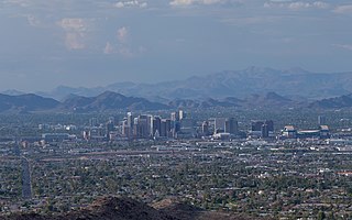
The Phoenix metropolitan area, also known as the Valley of the Sun, the Salt River Valley, metro Phoenix, or The Valley, is the largest metropolitan statistical area in the Southwestern United States, with its largest principal city being the city of Phoenix. It includes much of central Arizona. The United States Office of Management and Budget designates the area as the Phoenix–Mesa–Chandler Metropolitan Statistical Area (MSA), defining it as Maricopa and Pinal counties. It anchors the Arizona Sun Corridor megaregion along with the second-most populous metropolitan area in the state, the Tucson metropolitan area. The gross domestic product of the Phoenix metropolitan area was $255 billion in 2018, 16th highest amongst metro areas in the United States.
The Ak Chin Indian Community of the Maricopa (Ak-Chin) Indian Reservation is a federally recognized tribe and Native American community located in the Santa Cruz Valley in Pinal County, Arizona, 37 miles south of Phoenix and near the city of Maricopa. The Community is composed mainly of Akimel Oʼodham and Tohono Oʼodham, as well as some ethnic Hia-Ced Oʼodham members. According to the 2020 United States Census, the reservation has 1,070 residents. The Community comprises over 1,100 members that live on and off the reservation.
Laveen is a community in Maricopa County, Arizona, United States, situated eight miles (13 km) southwest of Downtown Phoenix, between South Mountain and the confluence of the Gila and Salt rivers. Parts of Laveen constitute an unincorporated community in Maricopa County, while the remainder falls within the city limits of Phoenix, constituting the city's "Laveen Village" an urban village within the city of Phoenix. Laveen Village is split between District 7 and District 8, both notable as minority-majority districts for the city. Although Laveen has been home to "pastoral alfalfa, cotton, and dairy farms" since the 1880s, housing and commercial developments have been increasingly urbanizing the area.
State Route 238, also known as SR 238, is an east–west state highway in central Arizona.
State Route 347 is a 28.69 miles (46.17 km) long, north–south state highway in central Arizona. The route begins at SR 84 and heads north. It passes through Maricopa, meeting SR 238. The route ends at an interchange with Interstate 10 (I-10) south of Chandler. It primarily serves as the major road to Maricopa; much of the road lies within the Gila River Indian Community, with another short stretch through the Ak-Chin Indian Community. The road was built in the late 1930s and established as a state highway in the 1990s. Most of it is also known as the John Wayne Parkway. On average, between 4,000 and 35,000 vehicles use the roadway daily.
The Salt River Pima–Maricopa Indian Community (SRPMIC) comprises two distinct Native American tribes—the Pima and the Maricopa —many of whom were originally part of the Halchidhoma (Xalchidom) tribe. The community was permanently created by an Executive Order of US President Rutherford B. Hayes on June 14th, 1879. The community area includes 53,600 acres (217 km2), of which 19,000 remain a natural preserve. As of 2022, the total population is 7,386. The community is a federally recognized tribe located in Arizona.
Many arterial roads in the Phoenix metropolitan area have the same name in multiple cities or towns. Some roads change names or route numbers across town borders, resulting in occasional confusion. For example, the road known as Apache Boulevard in Tempe continues east as Main Street in neighboring Mesa and then as Apache Trail in Apache Junction. Although Broadway Road maintains the same name through Goodyear, Avondale, Phoenix, Tempe, Mesa, and Apache Junction, each town uses a different reference point for address numbers.
Maricopa Wells is a former place (locale) situated in Pinal County, Arizona. It has an estimated elevation of 1,093 feet (333 m) above sea level. Historically, it was an oasis around a series of watering holes in the Sierra Estrella, eight miles north of present-day Maricopa, Arizona, and about a mile west of Pima Butte. It developed as a trading center and stopping place for travelers in the mid to late 19th century.
Sacate Village is a census-designated place in Pinal County, in the U.S. state of Arizona. The population was 169 at the 2010 census.
Sacate is a populated place in the Middle Gila River Valley area, within Pinal County, Arizona, United States. Located 8 mi (13 km) north of Maricopa on the south side of the Gila River near Pima Butte, Sacate was an Pima village, a railroad station of the Southern Pacific Railroad, and a Catholic mission. It had originally been called Sacaton Station but the name was shortened to its current version in 1904.
This page is based on this Wikipedia article Text is available under the CC BY-SA 4.0 license; additional terms may apply. Images, videos and audio are available under their respective licenses.