Gilbert, Arizona | |
---|---|
Motto(s): "Gilbert: Clean, Safe, Vibrant" | |
Coordinates: 33°21′10″N111°47′20″W / 33.35278°N 111.78889°W | |
Country | United States |
State | Arizona |
County | Maricopa |
Founded | 1891 |
Incorporated | July 6, 1920 |
Named for | Robert Gilbert |
Government | |
• Mayor | Brigette Peterson |
Area | |
• Total | 68.86 sq mi (178.35 km2) |
• Land | 68.66 sq mi (177.84 km2) |
• Water | 0.20 sq mi (0.53 km2) |
Elevation | 1,237 ft (377 m) |
Population | |
• Total | 267,918 |
• Estimate (2022) [4] | 275,346 |
• Rank | US: 80th AZ: 5th |
• Density | 4,010/sq mi (1,549/km2) |
Time zone | UTC–7 (Mountain (MST) (no DST)) |
ZIP Codes | 85233, 85234, 85295, 85296, 85297, 85298, 85299 |
Area code | 480 |
FIPS code | 04-27400 |
GNIS feature ID | 0005032 [2] |
Sales tax | 7.8% [5] |
Website | gilbertaz.gov |
Gilbert is a large town in Maricopa County, Arizona, United States, located southeast of Phoenix within the city's metropolitan area. Incorporated on July 6, 1920, Gilbert was once known as the "Hay Shipping Capital of the World". [6] The population was 267,918 at the 2020 census, [3] and was estimated to be 275,346 in 2022. [4] It is the fifth-largest municipality in Arizona, and the fourth-largest in the Phoenix metro area. It covers an area of nearly 69 square miles (179 km2).
Gilbert has made a rapid transformation from an agriculture-based community to an economically diverse suburban center located in the southeastern valley of the Greater Phoenix area. It has grown at an extremely high rate over the last three decades, increasing in population from 5,717 in 1980 to 267,918 as of the 2020 census. The town grew at an average annual rate of over 10% during this 40-year period. It is the largest incorporated town in the United States. [3]
Gilbert was established by William "Bobby" Gilbert, who provided land to the Arizona Eastern Railway in 1902 to construct a rail line between Phoenix and Florence, Arizona. Ayer's Grocery Store, the first store in Gilbert, opened in 1910 and became the location of the first post office in 1912. The location of the town post office moved several times before settling on the east side of Gilbert Road in downtown, where it still stands today. In 1912, many Mormons who had fled the Mormon colonies in Mexico due to the actions of the forces of Pancho Villa settled in Gilbert. By 1915, they began holding church meetings at the Gilbert Elementary School. In 1918, they were organized into the Gilbert Ward. [7]
Incorporated on July 6, 1920, Gilbert was primarily a farming community fueled by the rail line and construction of the Roosevelt Dam and the Eastern and Consolidated Canals. It remained an agricultural town for many years and was known as the "Hay Capital of the World" [8] from 1911 until the late 1920s.
In 2019, the town ranked highly on three national surveys, related to safety, livability and family life; it was named the fourth-safest (of 182 communities), twelfth-most livable town, and seventh-best place to raise a family in the United States. [9]
Gilbert is located in the southeast portion of the Phoenix metropolitan area. It is south of Mesa, northeast of Chandler, and northwest of Queen Creek. [10]
According to the United States Census Bureau, the town has a total area of 68.86 square miles (178.35 km2), of which, 68.65 square miles (177.80 km2) is land and 0.20 square miles (0.52 km2) is water. [1]
Gilbert has a subtropical, hot desert type of climate (Köppen climate classification BWh) with dry and hot summers, and mild to warm winters, with little rainfall.
Climate data for Gilbert, Arizona | |||||||||||||
---|---|---|---|---|---|---|---|---|---|---|---|---|---|
Month | Jan | Feb | Mar | Apr | May | Jun | Jul | Aug | Sep | Oct | Nov | Dec | Year |
Record high °F (°C) | 89 (32) | 95 (35) | 99 (37) | 106 (41) | 118 (48) | 116 (47) | 119 (48) | 115 (46) | 113 (45) | 107 (42) | 97 (36) | 86 (30) | 119 (48) |
Mean daily maximum °F (°C) | 67 (19) | 71 (22) | 77 (25) | 85 (29) | 94 (34) | 104 (40) | 106 (41) | 104 (40) | 99 (37) | 89 (32) | 75 (24) | 67 (19) | 87 (30) |
Mean daily minimum °F (°C) | 41 (5) | 45 (7) | 49 (9) | 54 (12) | 61 (16) | 70 (21) | 77 (25) | 76 (24) | 70 (21) | 59 (15) | 47 (8) | 40 (4) | 57 (14) |
Record low °F (°C) | 15 (−9) | 19 (−7) | 24 (−4) | 30 (−1) | 37 (3) | 43 (6) | 54 (12) | 51 (11) | 40 (4) | 30 (−1) | 22 (−6) | 17 (−8) | 15 (−9) |
Average precipitation inches (mm) | 1.01 (26) | 1.03 (26) | 1.19 (30) | 0.33 (8.4) | 0.13 (3.3) | 0.04 (1.0) | 0.89 (23) | 1.14 (29) | 0.89 (23) | 0.81 (21) | 0.77 (20) | 0.98 (25) | 9.21 (235.7) |
Source: The Weather Channel [11] |
Climate data for Gilbert | |||||||||||||
---|---|---|---|---|---|---|---|---|---|---|---|---|---|
Month | Jan | Feb | Mar | Apr | May | Jun | Jul | Aug | Sep | Oct | Nov | Dec | Year |
Mean daily daylight hours | 10.0 | 11.0 | 12.0 | 13.0 | 14.0 | 14.5 | 14.0 | 13.5 | 12.5 | 11.5 | 10.5 | 10.0 | 12.2 |
Source: Weather Atlas [12] |
Census | Pop. | Note | %± |
---|---|---|---|
1920 | 865 | — | |
1930 | 791 | −8.6% | |
1940 | 837 | 5.8% | |
1950 | 1,114 | 33.1% | |
1960 | 1,833 | 64.5% | |
1970 | 1,971 | 7.5% | |
1980 | 5,717 | 190.1% | |
1990 | 29,188 | 410.5% | |
2000 | 109,697 | 275.8% | |
2010 | 208,453 | 90.0% | |
2020 | 267,918 | 28.5% | |
2022 (est.) | 275,346 | [4] | 2.8% |
U.S. Decennial Census [13] 2020 Census [3] |
As of the 2020 census, there were 267,918 people and 88,896 households, and 69,603 families residing in the town. [14] There were 93,230 housing units.
As of the 2010 census, there were 208,453 people, 74,147 housing units, and 3.01 persons per household.
According to Nielsen's Claritas demographics, [17] in 2009 the estimated racial makeup of the town was:
2009 estimated population data by gender/age: [17]
2009 estimated population age 15+ by marital status: [17]
2009 estimated population age 25+ educational attainment: [17]
2009 estimated household by household income: [17]
Race / Ethnicity | Pop 2010 [18] | Pop 2020 [19] | % 2010 | % 2020 |
---|---|---|---|---|
White alone (NH) | 151,930 | 178,671 | 72.88% | 66.69% |
Black or African American alone (NH) | 6,606 | 9,601 | 3.17% | 3.58% |
Native American or Alaska Native alone (NH) | 1,394 | 1,998 | 0.67% | 0.75% |
Asian alone (NH) | 11,877 | 17,690 | 5.70% | 6.60% |
Pacific Islander alone (NH) | 406 | 574 | 0.19% | 0.21% |
Some Other Race alone (NH) | 264 | 1,211 | 0.13% | 0.45% |
Mixed Race/Multi-Racial (NH) | 4,902 | 13,041 | 2.35% | 4.87% |
Hispanic or Latino (any race) | 31,074 | 45,132 | 14.91% | 16.85% |
Total | 208,453 | 267,918 | 100.00% | 100.00% |
Various religious denominations are represented in Gilbert. The town has been known for its high population of members of the Church of Jesus Christ of Latter-day Saints, a fact evidenced by the building of the Gilbert Arizona Temple, which was dedicated on March 2, 2014. [20] [21]
According to the town's 2022 Comprehensive Annual Financial Report, [22] the top employers in the city are:
# | Employer | # of employees |
---|---|---|
1 | Gilbert Public Schools | 3,098 |
2 | Banner Health | 2,465 |
3 | Town Of Gilbert | 1,679 |
4 | Fry's Food and Drug | 1,518 |
5 | Higley Unified School District | 1,246 |
6 | Walmart | 1,218 |
7 | Go Daddy | 1,159 |
8 | Northrop Grumman | 1,078 |
9 | Dignity Health | 878 |
10 | Silent Aire USA | 778 |
Gilbert is home to a 9/11 Memorial, located at Town Hall [23] that features an eight-foot steel girder beam [24] which held up the North Tower of the World Trade Center.[ citation needed ] Former Gilbert Fire Chief Collin DeWitt fund-raised extensively for three years to create the memorial, and to bring the beam from New York City to Arizona. He drove to collect it himself along with his then Assistant Fire Chief Jim Jobusch. [25]
The design of the memorial angles the beam, which puts it in reach of everyone. Four granite walls bear the names of those lost to the attacks. Concrete was poured in the shape of a pentagon for the foundation of the memorial, [26] and is surrounded by bricks which carry names of some of those who helped to donate to bring the memorial to life. There was an unveiling ceremony of the memorial on the 10th anniversary of the attack on September 11, 2011. [27]
Gilbert Elementary School was built in 1913, and now houses the Gilbert Historical Museum. It is listed in the National Register of Historic Places. [28]
Gilbert Regional Park and Desert Sky Park were established in 2019 with multi-million dollar investments.
The Freestone Recreation Center, north of Freestone Park, was opened in 2002. It has a rock wall, a gymnasium, a steam room and dry sauna, and exercise equipment. [9]
Gilbert was recognized in 2010 as the "36th Best Place to Live in the nation", [29] as well as among the nation's "top places to live and learn", [29] by GreatSchools.org. Washington, DC-based CQ Press rated Gilbert the "safest municipality in Arizona, and 25th safest in the nation." [30]
Since Gilbert remains incorporated as a town, it lacks the additional powers possessed by nearby Mesa and Chandler, which are incorporated as cities. For instance, Arizona towns do not have as much power to regulate utilities and construction within their borders as cities possess. [31] Unlike most of its neighboring communities, Gilbert is theoretically vulnerable to annexation. [32]
The town is part of Arizona's 5th congressional district , which is represented by Republican and Gilbert resident Andy Biggs. [33] The mayor of Gilbert is Brigette Peterson. [34]
Mayors of Gilbert, Arizona | |||||||||||||||||||||||||||||||||||||||||||||||||||||||||||||||||||||||||||||||||||||||||||||||||||||||||||||||||||||||||||||||||||||||||||||
---|---|---|---|---|---|---|---|---|---|---|---|---|---|---|---|---|---|---|---|---|---|---|---|---|---|---|---|---|---|---|---|---|---|---|---|---|---|---|---|---|---|---|---|---|---|---|---|---|---|---|---|---|---|---|---|---|---|---|---|---|---|---|---|---|---|---|---|---|---|---|---|---|---|---|---|---|---|---|---|---|---|---|---|---|---|---|---|---|---|---|---|---|---|---|---|---|---|---|---|---|---|---|---|---|---|---|---|---|---|---|---|---|---|---|---|---|---|---|---|---|---|---|---|---|---|---|---|---|---|---|---|---|---|---|---|---|---|---|---|---|---|
|
Most of Gilbert is zoned to schools in the Gilbert Public Schools, while other portions are zoned to districts including the Chandler Unified School District, Mesa Public Schools, and the Higley Unified School District. Also in Gilbert are charter schools such as Eduprize (the first charter school in Arizona), American Leadership Academy, and Legacy Traditional School. The town is also home to Gilbert Christian Schools, a chain of private schools. In 2018, the Park University opened the Gilbert Campus Center after leasing 18,000-square-foot (1,700 m2) at the University Building in the city's Heritage District. [38]
Gilbert is primarily served by one area freeway—the Santan Freeway portion of Loop 202. A small section of the US 60 Superstition Freeway also skirts the northern boundary of the town at the Higley Road interchange (Exit 186). Several regional arterials also serve the area, including Williams Field Road, Chandler Boulevard, and Gilbert Road. The town enjoys relative closeness to Phoenix Mesa Gateway Airport, which is located in east Mesa, and is a 25-minute drive from Phoenix Sky Harbor International Airport.
Recently, a park-and-ride facility was constructed in downtown Gilbert for bus service and future commuter rail service. Although the facility borders the Union Pacific (formerly Southern Pacific) tracks and has provisions for commuter rail service, there is currently no such service. Bus service is limited in Gilbert, with some north–south routes in Mesa dead-ending at Baseline Road before entering Gilbert. Routes that serve portions of Gilbert include the 108-Elliot Road, 112-Country Club/Arizona Avenue, 136-Gilbert Road, 140-Ray Road, 156-Chandler Boulevard/Williams Field Road, 184-Power Road, and 531-Mesa/Gilbert Express, with most of these routes operating at 30-minute frequency on weekdays. Sunday service is only available on Routes 108, 112, 156, and 184. Most people get around by cars or bikes. The city of Gilbert has a low percentage of households without a car. In 2015, 1.9 percent of Gilbert households lacked a car, and the figure was virtually unchanged in 2016 (1.7 percent). The national average was 8.7 percent in 2016. Gilbert averaged 2.08 cars per household in 2016, compared to a national average of 1.8. [39]
In 2018 Waymo started testing in a small portion of the northwest portion of the town of Gilbert. [40]
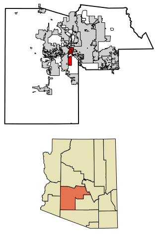
Maricopa County is in the south-central part of the U.S. state of Arizona. As of the 2020 census the population was 4,420,568, or about 62% of the state's total, making it the fourth-most populous county in the United States and the most populous county in Arizona, and making Arizona one of the nation's most centralized states. The county seat is Phoenix, the state capital and fifth-most populous city in the United States.
Page is a city in Coconino County, Arizona, United States, near the Glen Canyon Dam and Lake Powell. As of the 2010 census, the population of the city was 7,247.
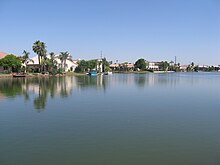
Apache Junction is a city in Pinal and Maricopa County, Arizona, United States. As of the 2020 census, the population was 38,499, most of whom lived in Pinal County. It is named for the junction of the Apache Trail and Old West Highway. The area where Apache Junction is located used to be known as Youngberg. Superstition Mountain, the westernmost peak of the Superstition Mountains, is to the east.
Avondale is a city in Maricopa County, Arizona, United States, adjacent to Phoenix. As of the 2020 census, the population of the city was 89,334, up from 76,238 in 2010 and 35,883 in 2000.
Cave Creek is a town in Maricopa County, Arizona, United States. It is part of the Phoenix metropolitan area. As of the 2020 census, the population of the town was 4,892.
Chandler is a city in Maricopa County, Arizona, United States, and a suburb in the Phoenix-Mesa-Chandler Metropolitan Statistical Area. Chandler is considered to be a part of the East Valley.
Glendale is a city in Maricopa County, Arizona, United States. Located about nine miles northwest of the state capital Phoenix, Glendale is known for State Farm Stadium, which is the home of the Arizona Cardinals football team. The city also contains the Arrowhead Towne Center shopping mall. As of the 2020 census, Glendale had a population of 248,325.
Goodyear is a city in Maricopa County, Arizona, United States. It is a suburb of Phoenix and at the 2020 census had a population of 95,294, up from 65,275 in 2010 and 18,911 in 2000. It was the third-fastest-growing city in Arizona between 1990 and 2000.
Mesa is a city in Maricopa County, Arizona, United States. It is the third-most populous city in Arizona, after Phoenix and Tucson, the 36th-most populous city in the U.S., and the most populous city that is not a county seat. The city is home to 504,258 people as of 2020. It is the most populous city in the East Valley of the Phoenix metropolitan area. It is bordered by Tempe on the west, the Salt River Pima–Maricopa Indian Community on the north, Chandler and Gilbert on the south along with Queen Creek, and Apache Junction on the east.
Queen Creek is a town in Maricopa and Pinal counties, Arizona, United States. The population was 59,519 at the 2020 census. It is a suburb of Phoenix, located in the far southeast area of the Phoenix Metropolitan Area. A large battery factory is being constructed.
Tempe is a city in Maricopa County, Arizona, United States, with the Census Bureau reporting a 2020 population of 180,587. The city is named after the Vale of Tempe in Greece. Tempe is located in the East Valley section of metropolitan Phoenix; it is bordered by Phoenix and Guadalupe on the west, Scottsdale and the Salt River Pima–Maricopa Indian Community on the north, Chandler on the south, and Mesa on the east. Tempe is also the location of the main campus of Arizona State University.
Youngtown is a town in Maricopa County, Arizona, United States. As of the 2020 census, the population of the town was 7,056, up from 6,156 in 2010. It is part of the Phoenix metropolitan area.
Kykotsmovi Village, also known as K-Town or New Oraibi is a census-designated place (CDP) in Navajo County, Arizona, United States. It is the seat of tribal government of the Hopi Reservation, a sovereign nation located in northeastern Arizona. The Hopi word is spelled Kiqötsmovi and means "mound of ruined houses". The population was 776 at the 2000 census. The Hopi reservation occupies part of Coconino and Navajo counties, encompasses more than 1.5 million acres, and is made up of 12 villages on three mesas. Kykotsmovi is one of the 12 villages located in third mesa. Third Mesa includes Hotvela (Hotevilla), Paaqavi (Bacavi), Munqapi (Moencopi), Kiqotsmovi (Kykotsmovi), and Orayvi (Oraibi).
Maricopa is a city in the Gila River Valley in Pinal County, Arizona, United States. With 66,290 residents as of 2022, Maricopa is the largest incorporated municipality in Pinal County.
Murrieta is a city in southwestern Riverside County, California, United States. The population of Murrieta was 110,949 as of the 2020 census. Murrieta experienced a 133.7% population increase between 2000 and 2010, making Murrieta one of the fastest-growing cities in the state during that period. Largely residential in character, Murrieta is typically characterized as a bedroom community. Murrieta is bordered by the city of Temecula to the south, the cities of Menifee and Wildomar to the north, and the unincorporated community of French Valley to the east. Murrieta is located in the center of the Los Angeles-San Diego mega-region. Murrieta is named for Juan Murrieta, a Californio ranchero who founded the town.
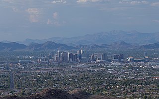
The Phoenix metropolitan area, also known as the Valley of the Sun, the Salt River Valley, metro Phoenix, or The Valley, is the largest metropolitan statistical area in the Southwestern United States, with its largest principal city being the city of Phoenix. It includes much of central Arizona. The United States Office of Management and Budget designates the area as the Phoenix–Mesa–Chandler Metropolitan Statistical Area (MSA), defining it as Maricopa and Pinal counties. It anchors the Arizona Sun Corridor megaregion along with the second-most populous metropolitan area in the state, the Tucson metropolitan area. The gross domestic product of the Phoenix metropolitan area was $255 billion in 2018, 16th highest amongst metro areas in the United States.
Anthem is a planned community partially located within Phoenix and partially located within New River, a census-designated place. The community is entirely located in Maricopa County, Arizona, United States, within the Phoenix Metropolitan Area. As of the 2020 census, the population of the Anthem was 23,190.
The Phoenix Metropolitan Area consists of a valley that has multiple city regions in it. The East Valley is a multi-city region within the Phoenix Metropolitan Area of Arizona. East Valley is a loosely defined region, with differing definition of what constitutes it.
The following is a timeline of the history of the area which today comprises the U.S. state of Arizona. Situated in the desert southwest, for millennia the area was home to a series of Pre-Columbian peoples. By 1 AD, the dominant groups in the area were the Hohokam, the Mogollon, and the Ancestral Puebloans. The Hohokam dominated the center of the area which is now Arizona, the Mogollon the southeast, and the Puebloans the north and northeast. As these cultures disappeared between 1000 and 1400 AD, other Indian groups settled in Arizona. These tribes included the Navajo, Apache, Southern Paiute, Hopi, Yavapai, Akimel O'odham, and the Tohono O'odham.
{{cite web}}
: CS1 maint: numeric names: authors list (link)