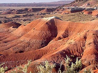
The Painted Desert is a United States desert of badlands in the Four Corners area, running from near the east end of Grand Canyon National Park and southeast into Petrified Forest National Park. It is most easily accessed from the north portion of Petrified Forest National Park. The Painted Desert is known for its brilliant and varied colors: these include the more common red rock, but also shades of lavender.

The Southwestern United States, also known as the American Southwest or simply the Southwest, is a geographic and cultural region of the United States that includes Arizona and New Mexico, along with adjacent portions of California, Colorado, Nevada, Oklahoma, Texas, and Utah. The largest cities by metropolitan area are Phoenix, Las Vegas, El Paso, Albuquerque, and Tucson. Before 1848, in the historical region of Santa Fe de Nuevo México as well as parts of Alta California and Coahuila y Tejas, settlement was almost non-existent outside of Nuevo México's Pueblos and Spanish or Mexican municipalities. Much of the area had been a part of New Spain and Mexico until the United States acquired the area through the Treaty of Guadalupe Hidalgo in 1848 and the smaller Gadsden Purchase in 1854.

The Sonoran Desert is a hot desert in North America and ecoregion that covers the northwestern Mexican states of Sonora, Baja California, and Baja California Sur, as well as part of the southwestern United States. It is the hottest desert in both Mexico and the United States. It has an area of 260,000 square kilometers (100,000 sq mi).

The Salt River is a river in Gila and Maricopa counties in Arizona, United States, that is the largest tributary of the Gila River. The river is about 200 miles (320 km) long. Its drainage basin covers about 13,700 square miles (35,000 km2). The longest of the Salt River's many tributaries is the 195-mile (314 km) Verde River. The Salt's headwaters tributaries, the Black River and East Fork, increase the river's total length to about 300 miles (480 km). The name Salt River comes from the river's course over large salt deposits shortly after the merging of the White and Black Rivers.

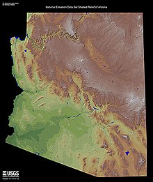
The Colorado Plateau, also known as the Colorado Plateau Province, is a physiographic and desert region of the Intermontane Plateaus, roughly centered on the Four Corners region of the southwestern United States. This province covers an area of 336,700 km2 (130,000 mi2) within western Colorado, northwestern New Mexico, southern and eastern Utah, northern Arizona, and a tiny fraction in the extreme southeast of Nevada. About 90% of the area is drained by the Colorado River and its main tributaries: the Green, San Juan, and Little Colorado. Most of the remainder of the plateau is drained by the Rio Grande and its tributaries.

The Tonto National Forest, encompassing 2,873,200 acres, is the largest of the six national forests in Arizona and is the ninth largest national forest in the United States. The forest has diverse scenery, with elevations ranging from 1,400 feet in the Sonoran Desert to 7,400 feet in the ponderosa pine forests of the Mogollon Rim. The Tonto National Forest is also one of the most visited "urban" forests in the United States.

Northern Arizona is an unofficial, colloquially defined region of the U.S. state of Arizona. Generally consisting of Apache, Coconino, Mohave, Navajo, and Yavapai counties, the region is geographically dominated by the Colorado Plateau, the southern border of which in Arizona is called the Mogollon Rim.

Greer is an unincorporated community and census-designated place in Apache County, Arizona, United States. Located within the White Mountains of Arizona and surrounded by the Apache-Sitgreaves National Forest, Greer is the highest town in the state at an elevation of approximately 8,400 feet. As of the 2020 census it had a population of 58. Greer was founded circa 1879 by Mormon settlers from Utah. The Greer post office has the ZIP code of 85927.

The history of Arizona encompasses the Paleo-Indian, Archaic, Post-Archaic, Spanish, Mexican, and American periods. About 10,000 to 12,000 years ago, Paleo-Indians settled in what is now Arizona. A few thousand years ago, the Ancestral Puebloan, the Hohokam, the Mogollon and the Sinagua cultures inhabited the state. However, all of these civilizations mysteriously disappeared from the region in the 15th and 16th centuries. Today, countless ancient ruins can be found in Arizona. Arizona was part of the state of Sonora, Mexico from 1822, but the settled population was small. In 1848, under the terms of the Mexican Cession the United States took possession of Arizona above the Gila River after the Mexican War, and became part of the Territory of New Mexico. By means of the Gadsden Purchase, the United States secured the northern part of the state of Sonora, which is now Arizona south of the Gila River in 1854.

The Spanish missions in the Sonoran Desert are a series of Jesuit Catholic religious outposts established by the Spanish Catholic Jesuits and other orders for religious conversions of the Pima and Tohono O'odham indigenous peoples residing in the Sonoran Desert. An added goal was giving Spain a colonial presence in their frontier territory of the Sonora y Sinaloa Province in the Viceroyalty of New Spain, and relocating by Indian Reductions settlements and encomiendas for agricultural, ranching, and mining labor.

The following is an alphabetical list of articles related to the U.S. state of Arizona.

Aridoamerica denotes an ecological region spanning Northern Mexico and the Southwestern United States, defined by the presence of the culturally significant staple foodstuff Phaseolus acutifolius, a drought-resistant bean. Its dry, arid climate and geography stand in contrast to the verdant Mesoamerica of present-day central Mexico into Central America to the south and east, and the higher, milder "island" of Oasisamerica to the north. Aridoamerica overlaps with both.

Bursera microphylla, known by the common name elephant tree in English or 'torote' in Spanish, is a tree in genus Bursera. It grows into a distinctive sculptural form, with a thickened, water-storing or caudiciform trunk. It is found in the southwestern United States and northwestern Mexico.

The Lower Colorado River Valley (LCRV) is the river region of the lower Colorado River of the southwestern United States in North America that rises in the Rocky Mountains and has its outlet at the Colorado River Delta in the northern Gulf of California in northwestern Mexico, between the states of Baja California and Sonora. This north–south stretch of the Colorado River forms the border between the U.S. states of California/Arizona and Nevada/Arizona, and between the Mexican states of Baja California/Sonora.

Arizona is a landlocked state situated in the southwestern region of the United States of America. It has a vast and diverse geography famous for its deep canyons, high- and low-elevation deserts, numerous natural rock formations, and volcanic mountain ranges. Arizona shares land borders with Utah to the north, the Mexican state of Sonora to the south, New Mexico to the east, and Nevada to the northwest, as well as water borders with California and the Mexican state of Baja California to the southwest along the Colorado River. Arizona is also one of the Four Corners states and is diagonally adjacent to Colorado.

Arizona is a landlocked state in the Southwestern region of the United States. Arizona is part of the Four Corners region with Utah to the north, Colorado to the northeast, and New Mexico to the east; its other neighboring states are Nevada to the northwest, California to the west and the Mexican states of Sonora and Baja California to the south and southwest. It is the 6th-largest and the 14th-most-populous of the 50 states. Its capital and largest city is Phoenix.
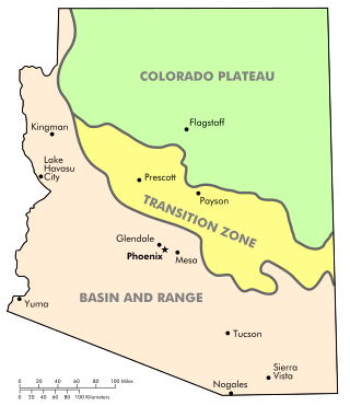
The Arizona transition zone is a diagonal northwest-by-southeast region across central Arizona. The region is a transition from the higher-elevation Colorado Plateau in Northeast Arizona and the Basin and Range region of lower-elevation deserts in the southwest and south.

Platanus wrightii, the Arizona sycamore, is a sycamore tree native to Arizona and New Mexico with its range extending south into the Mexican states of Sonora, Chihuahua, and Sinaloa.

This article details the history of Sonora. The Free and Sovereign State of Sonora is one of 31 states that, with the Federal District, comprise the 32 Federal Entities of Mexico. It is divided into 72 municipalities; the capital city is Hermosillo. Sonora is located in Northwest Mexico, bordered by the states of Chihuahua to the east, Baja California to the northwest and Sinaloa to the south. To the north, it shares the U.S.–Mexico border with the states of Arizona and New Mexico, and on the west has a significant share of the coastline of the Gulf of California.