Territorial evolution of Arizona

Last updated
An enlargeable map of the United States after the Constitution of the United States was ratified on March 4, 1789. United States 1789-03-1789-08.png
An enlargeable map of the United States after the Constitution of the United States was ratified on March 4, 1789.
An enlargeable map of the United States after the Treaty of Cordoba was signed on August 24, 1821. United States 1821-07-1821-08.png
An enlargeable map of the United States after the Treaty of Córdoba was signed on August 24, 1821.
An enlargeable map of the United States after the Treaty of Guadalupe Hidalgo was signed on February 2, 1848. United States 1848-02-1848-05.png
An enlargeable map of the United States after the Treaty of Guadalupe Hidalgo was signed on February 2, 1848.
An enlargeable map of the United States after the creation of the proposed State of Deseret on July 2, 1849. United States Central change 1849-03-12.png
An enlargeable map of the United States after the creation of the proposed State of Deseret on July 2, 1849.
An enlargeable map of the United States after the creation of the Territory of New Mexico and the Territory of Utah on September 9, 1850. United States 1850-1853-03.png
An enlargeable map of the United States after the creation of the Territory of New Mexico and the Territory of Utah on September 9, 1850.
An enlargeable map of the United States after Gadsden Purchase on December 30, 1853. United States 1853-12-1854.png
An enlargeable map of the United States after Gadsden Purchase on December 30, 1853.
An enlargeable map of the United States after the creation of the Territory of Colorado on February 28, 1861. United States 1861-02-28-1861-03.png
An enlargeable map of the United States after the creation of the Territory of Colorado on February 28, 1861.
An enlargeable map of the United States after the creation of the Confederate Territory of Arizona on February 24, 1862. United States 1862-1863-02.png
An enlargeable map of the United States after the creation of the Confederate Territory of Arizona on February 24, 1862.
An enlargeable map of the United States after the creation of the Territory of Arizona on June 19, 1862. United States 1864-05-1864-10.png
An enlargeable map of the United States after the creation of the Territory of Arizona on June 19, 1862.
An enlargeable map of the United States after the annexation of northwestern Arizona on January 18, 1867. United States 1867-01-1867-03.png
An enlargeable map of the United States after the annexation of northwestern Arizona on January 18, 1867.
An enlargeable map of the United States after the admission of Arizona to the Union on February 14, 1912. United States 1912-02-1912-08.png
An enlargeable map of the United States after the admission of Arizona to the Union on February 14, 1912.
An enlargeable map of the United States as it has been since Hawaii`i was admitted to the Union on August 21, 1959. United States 1959-08-present.png
An enlargeable map of the United States as it has been since Hawaiiʻi was admitted to the Union on August 21, 1959.

The following timeline traces the territorial evolution of the U.S. State of Arizona .

Contents

Timeline

See also

Flag of California.svg Territorial evolution of California
Flag of Colorado.svg List of territorial claims and designations in Colorado
Flag of Nevada.svg Territorial evolution of Nevada
Flag of New Mexico.svg Territorial evolution of New Mexico
Flag of Utah.svg Territorial evolution of Utah

Related Research Articles

<span class="mw-page-title-main">Gadsden Purchase</span> Land purchased from Mexico by the United States in 1854

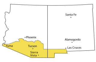
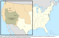
The Gadsden Purchase is a 29,670-square-mile (76,800 km2) region of present-day southern Arizona and southwestern New Mexico that the United States acquired from Mexico by the Treaty of Mesilla, which took effect on June 8, 1854. The purchase included lands south of the Gila River and west of the Rio Grande where the U.S. wanted to build a transcontinental railroad along a deep southern route, which the Southern Pacific Railroad later completed in 1881–1883. The purchase also aimed to resolve other border issues.

<span class="mw-page-title-main">Treaty of Guadalupe Hidalgo</span> 1848 agreement ending the Mexican–American War

The Treaty of Guadalupe Hidalgo officially ended the Mexican–American War (1846–1848). It was signed on 2 February 1848 in the town of Guadalupe Hidalgo.

<span class="mw-page-title-main">James Gadsden</span> American diplomat (1788–1858)

James Gadsden was an American diplomat, soldier and businessman after whom the Gadsden Purchase is named, pertaining to land which the United States bought from Mexico, and which became the southern portions of Arizona and New Mexico. James Gadsden served as Adjutant General of the U.S. Army from August 13, 1821 – March 22, 1822. Between 1853 and 1856, he served as U.S. Minister to Mexico. He was known commonly as General Gadsden, although he never had a rank above colonel.

<span class="mw-page-title-main">New Mexico Territory</span> Territory of the United States of America (1850–1912)

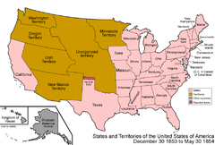
The Territory of New Mexico was an organized incorporated territory of the United States from September 9, 1850, until January 6, 1912. It was created from the U.S. provisional government of New Mexico, as a result of Nuevo México becoming part of the American frontier after the Treaty of Guadalupe Hidalgo. It existed with varying boundaries until the territory was admitted to the Union as the U.S. state of New Mexico. This jurisdiction was an organized, incorporated territory of the US for nearly 62 years, the longest period of any territory in the contiguous United States.

<span class="mw-page-title-main">Mexican Cession</span> Land the U.S. acquired from Mexico following war in 1848

The Mexican Cession is the region in the modern-day southwestern United States that Mexico originally controlled, then ceded to the United States in the Treaty of Guadalupe Hidalgo in 1848 after the Mexican–American War. This region had not been part of the areas east of the Rio Grande that had been claimed by the Republic of Texas, though the Texas annexation resolution two years earlier had not specified the southern and western boundary of the new state of Texas. At roughly 529,000 square miles (1,370,000 km2), the Mexican Cession was the third-largest acquisition of territory in U.S. history, surpassed only by the 827,000-square-mile (2,140,000 km2) Louisiana Purchase and the 586,000-square-mile (1,520,000 km2) Alaska Purchase.

<span class="mw-page-title-main">Arizona Territory</span> Territory of the United States from 1863 until statehood attained in 1912

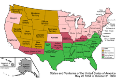
The Territory of Arizona was a territory of the United States that existed from February 24, 1863, until February 14, 1912, when the remaining extent of the territory was admitted to the Union as the state of Arizona. It was created from the western half of the New Mexico Territory during the American Civil War.

Events in the year 1848 in Mexico.

<span class="mw-page-title-main">Estado de Occidente</span> State of Mexico (1824–1830)

Estado de Occidente was a Mexican state established in 1824. The constitution was drafted in that year and the government was initially established with its capital at El Fuerte, Sinaloa. The first governor was Juan Miguel Riesgo. The state consisted of modern Sonora and Sinaloa, and also modern Arizona more or less south of the Gila River.

<span class="mw-page-title-main">Index of New Mexico–related articles</span>

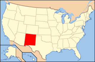
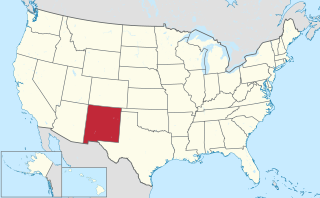
The following is an alphabetical list of articles related to the U.S. state of New Mexico.

The following outline is provided as an overview of and topical guide to the U.S. state of Arizona:

<span class="mw-page-title-main">Outline of Nevada</span> Overview of and topical guide to Nevada

The following outline is provided as an overview of and topical guide to the U.S. state of Nevada:

<span class="mw-page-title-main">Outline of New Mexico</span> Overview of and topical guide to New Mexico

The following outline is provided as an overview of and topical guide to the U.S. state of New Mexico:

<span class="mw-page-title-main">Outline of Wyoming</span> Overview of and topical guide to Wyoming

The following outline is provided as an overview of and topical guide to the U.S. state of Wyoming:

<span class="mw-page-title-main">Territorial evolution of New Mexico</span> Geographic chronology of New Mexico

The area currently occupied by the U.S. State of New Mexico has undergone numerous changes in occupancy and territorial claims and designations. This geographic chronology traces the territorial evolution of New Mexico.

<span class="mw-page-title-main">Outline of Wyoming territorial evolution</span>

The following outline traces the territorial evolution of the U.S. State of Wyoming.

<span class="mw-page-title-main">Territorial evolution of Utah</span>

The following timeline traces the territorial evolution of the U.S. State of Utah.

<span class="mw-page-title-main">Territorial evolution of Nevada</span>

The following outline traces the territorial evolution of the U.S. State of Nevada.

<span class="mw-page-title-main">Territorial evolution of California</span> Timeline

The following timeline traces the territorial evolution of California, the thirty-first state admitted to the United States of America, including the process of removing Indigenous Peoples from their native lands, or restricting them to reservations.

Hispanic and Latino Arizonians are residents of the state of Arizona who are of Hispanic or Latino ancestry. As of the 2010 U.S. Census, Hispanics and Latinos of any race were 30% of the state's population.

References

  1. Thirty-seventh United States Congress (February 24, 1863). "An Act to provide a temporary Government for the Territory of Arizona, and for other Purposes" . Retrieved June 5, 2009.
  2. Decisions of the Department of the Interior in cases relating to the public lands: 1927–1954. United States. Department of the Interior. Washington. For sale by the Supt. of Docs., U.S. Govt. Print. Off. pp. 25, 337. hdl:2027/mdp.39015084910804.