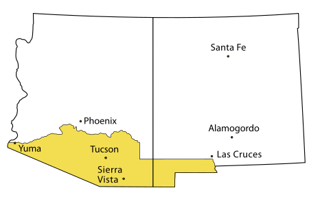
Tucson is a city in and the county seat of Pima County, Arizona, United States, and is home to the University of Arizona. It is the second largest city in Arizona, with a population of 542,629 in the 2020 United States Census, while the population of the entire Tucson metropolitan statistical area (MSA) is 1,043,433. The Tucson MSA forms part of the larger Tucson-Nogales combined statistical area (CSA). Tucson is the second most-populated city in Arizona behind Phoenix, both of which anchor the Arizona Sun Corridor. The city is 108 miles (174 km) southeast of Phoenix and 60 mi (97 km) north of the U.S.–Mexico border. Tucson is the 33rd largest city and the 58th largest metropolitan area in the United States (2014).
Interstate 19 (I-19) is a north–south Interstate Highway located entirely within the U.S. state of Arizona. I-19 travels from Nogales, roughly 300 feet (91 m) from the Mexican border, to Tucson, at I-10. The highway also travels through the cities of Rio Rico, Green Valley, and Sahuarita.

Pima County is a county in the south central region of the U.S. state of Arizona. As of the 2010 census, the population was 980,263, making it Arizona's second-most populous county. The county seat is Tucson, where most of the population is centered. The county is named after the Pima Native Americans who are indigenous to this area.
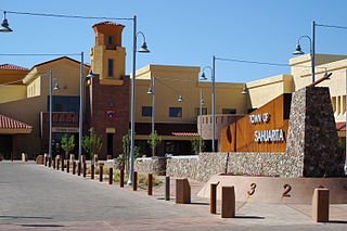
Sahuarita is a town in Pima County, Arizona, United States. Sahuarita is located south of the Tohono O'odham Nation and abuts the north end of Green Valley, 15 miles (24 km) south of Tucson. The population was 25,259 at the 2010 census.
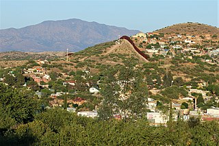
Nogales is a city in Santa Cruz County, Arizona. The population was 20,837 at the 2010 census and estimated 20,103 in 2019. Nogales forms part of the larger Tucson-Nogales combined statistical area, with a total population of 1,027,683 as of the 2010 Census. The city is the county seat of Santa Cruz County.
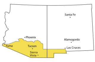
The Gadsden Purchase is a 29,670-square-mile (76,800 km2) region of present-day southern Arizona and southwestern New Mexico that the United States acquired from Mexico by the Treaty of Mesilla, which took effect on June 8, 1854. The purchase included lands south of the Gila River and west of the Rio Grande where the U.S. wanted to build a transcontinental railroad along a deep southern route, which the Southern Pacific Railroad later completed in 1881–1883. The purchase also aimed to resolve other border issues.
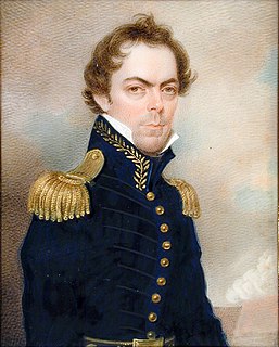
James Gadsden was an American diplomat, soldier and businessman after whom the Gadsden Purchase is named, pertaining to land which the United States bought from Mexico, and which became the southern portions of Arizona and New Mexico. James Gadsden served as Adjutant General of the U. S. Army from August 13, 1821 – March 22, 1822. Between 1853 and 1856, he served as U. S. Minister to Mexico. He was known commonly as General Gadsden, although he never had a rank above Colonel.
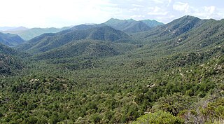
The Coronado National Forest is a United States National Forest that includes an area of about 1.78 million acres (7,200 km2) spread throughout mountain ranges in southeastern Arizona and southwestern New Mexico.
Interstate 11 (I-11) is an Interstate Highway that currently runs for 22.8 miles (36.7 km) on a predominantly northwest–southeast alignment in the U.S. state of Nevada, running concurrently with U.S. Route 93 (US 93) between the Arizona state line and Henderson. The freeway is tentatively planned to run from Nogales, Arizona, to the vicinity of Reno, Nevada, generally following the current routes of I-19, I-10, US 93 and US 95. Planners anticipate upgrading two existing highway segments to carry future I-11: US 93 in Arizona from Wickenburg to the Nevada state line on the Mike O'Callaghan–Pat Tillman Memorial Bridge over the Colorado River and US 95 in Nevada from the edge of the Las Vegas Valley to Tonopah. An exact alignment for I-11 has yet to be determined outside of these sections or through the Las Vegas Valley; however, a number of corridor alternatives have been identified for further study and refinement.
The CANAMEX corridor is a series of improvements to freeways and other transportation infrastructure linking Canada to Mexico through the United States. The corridor was established under the North American Free Trade Agreement. Currently the corridor is defined by a series of highways. However, the corridor is also proposed for use by railroads and fiber optic telecommunications infrastructure.

Area code 520 is a telephone area code in the North American Numbering Plan (NANP) for the U.S. state of Arizona. The numbering plan area comprises Tucson and most of the southeastern part of the state.
In the U.S. state of Arizona, Interstate 10 (I‑10), the major east–west Interstate Highway in the United States Sun Belt, runs east from California, enters Arizona near the town of Ehrenberg and continues through Phoenix and Tucson and exits at the border with New Mexico near San Simon. The highway also runs through the cities of Casa Grande, Eloy and Marana. Segments of the highway are referred to as either the Papago Freeway, Inner Loop or Maricopa Freeway within the Phoenix area and the Pearl Harbor Memorial Highway outside metro Phoenix.
Arizona State Route 93, abbreviated SR 93, was a state highway in Arizona that existed from 1946 to 1991. The route was co-signed with other highways along nearly all of its route from Kingman to the border at Nogales. SR 93 was the original designation for the highway from Kingman to Wickenburg, which was built in 1946. In 1965, the northern terminus of the state route was moved south to an unnamed desert junction with U.S. Route 89 just north of Wickenburg, and the southern terminus of U.S. Route 93 was moved south to the US 89 junction. The Arizona Highway Department sought U.S. Highway status for SR 93 across the rest of the state, but the proposal was never granted by AASHTO. On December 17, 1984, the SR 93 designation was removed south of the Grand Avenue/Van Buren Street/7th Avenue intersection in Phoenix. The route was completely decommissioned in 1991.
The transportation system of Arizona comprises car, rail, air, bus, and bicycle transport.

The Huachuca Mountains are part of the Sierra Vista Ranger District of the Coronado National Forest in Cochise County in southeastern Arizona, approximately 70 miles (110 km) south-southeast of Tucson and southwest of the city of Sierra Vista. Included in this area is the highest peak in the Huachucas, Miller Peak, and the region of the Huachucas known as Canelo Hills in eastern Santa Cruz County. The mountains range in elevation from 3,934 feet (1,199 m) at the base to 9,466 feet (2,885 m) at the top of Miller Peak. The second highest peak in this range is Carr Peak, elevation 9,200 feet (2,804 m). The Huachuca Mountain area is managed principally by the United States Forest Service (41%) and the U.S. Army (20%), with much of the rest being private land (32%). Sierra Vista is the main population center.

The West Silver Bell Mountains are a small 10 mile (16 km) long mountain range of south-central Arizona, United States. The range lies in the north-central arid Sonoran Desert; the Madrean Sky Islands region of southeast Arizona, around Tucson is adjacent to the southeast.
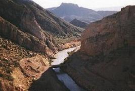
The Little Rincon Mountains are a small range of mountains, lying to the east of the Rincon Mountains, at Tucson, of eastern Pima County, Arizona. The range is located in northwest Cochise County and is part of the western border of the San Pedro River and Valley, the major valley and river of western Cochise County. The river is northward flowing to meet the Gila River; its headwaters are south of the US-Mexico border in northern Sonora. A small part of the Little Rincon range's southwest lies in Pima County.

The Arizona Sun Corridor, shortened Sun Corridor, is a megaregion, or megapolitan area, in the southern area of the U.S. state of Arizona. The Sun Corridor is comparable to Indiana in both size and population. It is one of the fastest growing conurbations in the country and is speculated to double its population by 2040. The largest metropolitan areas are the Phoenix metropolitan area - Valley of the Sun - and the Tucson metropolitan area. The regions' populace is nestled in the valley of a desert environment. Similar to Southern California, the urban area extends into Mexico, reaching the communities of Nogales and Agua Prieta.
The capital of the Arizona Territory was established in Prescott, but was moved to Tucson, back to Prescott, and finally to Phoenix over 25 years as political power shifted as the territory grew, developed, and stabilized. Each move was controversial.