Albuquerque metropolitan area

Last updated
Albuquerque Metropolitan Area
Albuquerque pano sunset.jpg
San Felipe de Neri Church Albuquerque.jpg
Abqdowntown.jpg
Belen harveyhouse.jpg
Moriarty New Mexico Municipal Center.jpg
Los Lunas New Mexico Public Library.jpg
Intel in Rio Rancho.jpg
Village Hall, Los Ranchos de Albuquerque New Mexico.jpg
BosqueNM.jpg
Route 66 east of Albuquerque.JPG
View to the southwest from Sandia Peak.jpg
(top-to-bottom, left-to-right) Panorama of the city of Albuquerque; San Felipe de Neri Church in Old Town Albuquerque; Downtown Albuquerque; Fred Harvey Company Harvey House museum in Belen; Moriarty municipal; Los Lunas; Intel Fab 11x in Rio Rancho; village hall in Los Ranchos; Rio Grande Bosque near Bernalillo; U.S. Route 66 in New Mexico; panorama from the Sandia Mountains peak
Albuquerque metropolitan area
Map of Albuquerque–Santa Fe–Los Alamos, NM
Country Flag of United States.svg United States
State Flag of New Mexico.svg New Mexico
Statistical Area Albuquerque-Santa Fe-Las Vegas, NM Combined Statistical Area
Principal counties
(cities)
Area
  Total9,297 sq mi (24,080 km2)
Elevation
(Average height)
5,312 ft (1,619 m)
Highest elevation10,678 ft (3,255 m)
Lowest elevation
(Near the Rio Grande, south of Jarales)
4,767 ft (1,453 m)
Population
  Total915,927 [1]
  Density95/sq mi (37/km2)
Time zone UTC−7 (MST)
  Summer (DST) UTC−6 (MDT)

The Albuquerque Metropolitan Statistical Area, sometimes referred to as Tiguex (named after the Southern Tiwa), [2] [3] [4] is a metropolitan area in central New Mexico centered on the city of Albuquerque. The metro comprises four counties: Bernalillo, Sandoval, Torrance, and Valencia. As of the 2010 United States Census, the MSA had a population of 887,077. [5] The population is estimated to be 923,630 as of July 1, 2020, [6] making Greater Albuquerque the 61st-largest MSA in the nation. The Albuquerque MSA forms a part of the larger Albuquerque–Santa Fe–Las Vegas combined statistical area with a 2020 estimated population of 1,165,181, ranked 49th-largest in the country.

Contents

History

It was the center of the Aztec legend of the Seven Cities of Gold, sometimes called the "cities of Cibola". The Tiguex Province of Santa Fe de Nuevo México was named after the Southern Tiwa speaking Puebloans in the area, they inhabited the area along with the Jemez and Keres people. The area between Bernalillo and Corrales was being farmed for sacramental wine since 1620, which started the New Mexico wine heritage. Following this early wine industry several Spanish towns were founded, including Barelas in 1662 and Bernalillo in 1695. The main city, Albuquerque, was founded on 1706 as La Villa de Alburquerque as the trade center for the region. During the 19th century, Nuevo México and its Tiguex Province were acquired by the United States as a part of the Treaty of Guadalupe Hidalgo. Becoming the New Mexico Territory it became a prominent aspect of the American frontier during the 19th century, being highlighted in Western fiction with Billy the Kid, Elfego Baca, and Geronimo becoming lasting icons in later adaptation to film. In the 20th century New Mexico gained statehood, and since then trade in the region grew due to growth in technology, media, and agriculture sectors, driven by the New Mexico Technology Corridor, media in Albuquerque, and New Mexican cuisine.

Counties

Communities

Cities

Towns

Villages

Census-designated places

Partial inclusions and future developments

Neighboring Laguna Pueblo borders the metropolitan area, and part of its boundaries are included the metropolitan population. Most notably the area surrounding Route 66 Resort and Casino.

Mesa del Sol in Albuquerque and Santolina on the West Mesa in rural Bernalillo County are planned for 100,000 inhabitants each and are New Mexico's largest such planned developments. [7] [8]

Demographics

Historical population
CensusPop.Note
1900 28,630
1910 23,606−17.5%
1920 29,85526.5%
1930 45,43052.2%
1940 69,39152.7%
1950 145,675109.9%
1960 321,982121.0%
1970 379,08517.7%
1980 523,10538.0%
1990 599,41614.6%
2000 729,64921.7%
2010 887,07721.6%
2020 916,5283.3%
U.S. Decennial Census [9] [10]

As of the 2010 United States Census, there were 887,077 people, 347,366 households, and 222,811 families residing within the MSA. The racial makeup of the MSA was 49.63% White, 2.68% African American, 5.86% Native American, 2.02% Asian, 0.10% Pacific Islander, 15.40% from one other race, and 4.32% from two or more races. Hispanic or Latino of any race were 46.70% of the population.

The median income for a household in the MSA was $47,383 and the median income for a family was $59,158. Males had a median income of $31,486 versus $20,497 for females. The per capita income for the MSA was $25,044. [11]

According to 2014-2018 census data, 89.7% of the population was a high school graduate or higher, and 34.7% had a bachelor's degree or higher. [12]

Labor force

Albuquerque MSA Estimated Employment (August 2006)

Bernalillo County304,855
Sandoval County48,055
Torrance County16,021
Valencia County30,591
Total399,522
Source: New Mexico Department of Labor [13]

See also

Related Research Articles

<span class="mw-page-title-main">Albuquerque, New Mexico</span> City in New Mexico, United States

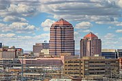
Albuquerque, also known as ABQ, Burque, and the Duke City, is the most populous city in the U.S. state of New Mexico. Founded in 1706 as La Villa de Alburquerque by Santa Fe de Nuevo México governor Francisco Cuervo y Valdés, and named in honor of Francisco Fernández de la Cueva, 10th Duke of Alburquerque and Viceroy of New Spain, it served as an outpost on El Camino Real linking Mexico City to the northernmost territories of New Spain.

<span class="mw-page-title-main">Sandoval County, New Mexico</span> County in New Mexico, United States

Sandoval County is located in the U.S. state of New Mexico. As of the 2020 census, the population was 148,834, making it the fourth-most populous county in New Mexico. The county seat is Bernalillo.

<span class="mw-page-title-main">Bernalillo County, New Mexico</span> County in New Mexico, United States

Bernalillo County is the most populous county in the U.S. state of New Mexico. As of the 2020 census, the population was 676,444. The county seat, Albuquerque, is the most populous city in New Mexico.

<span class="mw-page-title-main">Los Ranchos de Albuquerque, New Mexico</span> Village in New Mexico, United States

Los Ranchos de Albuquerque, known locally simply as "Los Ranchos" or "The Village," is a village in Bernalillo County, New Mexico. The population was 6,024 at the time of the 2010 Census.

<span class="mw-page-title-main">Bernalillo, New Mexico</span> Town in New Mexico, United States

Bernalillo is a town in and the county seat of Sandoval County, New Mexico, United States. As of the 2020 census, the town population was 8,977.

<span class="mw-page-title-main">Jemez Springs, New Mexico</span> Village in Sandoval County, New Mexico, United States

Jemez Springs is a village in Sandoval County, New Mexico, United States. The population was 250 at the 2010 census. Named for the nearby Pueblo of Jemez, the village is the site of Jemez State Monument and the headquarters of the Jemez Ranger District. The village and nearby locations in the Jemez Valley are the site of hot springs and several religious retreats.

<span class="mw-page-title-main">Pueblo of Sandia Village, New Mexico</span> Village in Sandoval County, New Mexico, US

Pueblo of Sandia Village is a census-designated place (CDP) in Sandoval County, New Mexico, United States. The population was 344 at the 2000 census. It is part of the Albuquerque Metropolitan Statistical Area.

<span class="mw-page-title-main">San Felipe Pueblo, New Mexico</span> CDP in New Mexico, United States

San Felipe Pueblo is a census-designated place (CDP) in Sandoval County, New Mexico, United States, and is located 10 miles (16 km) north of Bernalillo. As of the 2000 census, the CDP population was 2,080. It is part of the Albuquerque Metropolitan Statistical Area.

<span class="mw-page-title-main">Santa Ana Pueblo, New Mexico</span> CDP in New Mexico, United States

Santa Ana Pueblo is a census-designated place (CDP) in Sandoval County, New Mexico, United States. As of the 2000 census, the CDP had a total population of 479. It is part of the Albuquerque Metropolitan Statistical Area. The Pueblo, named Tamaya in Keres, administers a total reservation land of 73,000 acres (295 km2) in the Rio Grande valley and is composed of Native Americans who speak an eastern dialect of the Keresan languages.

<span class="mw-page-title-main">Corrales, New Mexico</span> Village in New Mexico, United States

Corrales is a village in southern Sandoval County, New Mexico, United States. First farmed by Tiquex Pueblo people, chosen due to its proximity to the Rio Grande, as documented by Hispano farmers of Nuevo México in the late 1500s. Despite being a part of the Albuquerque metropolitan area, the village maintains its rural character, while also being surrounded by the cities of Albuquerque and Rio Rancho. The population of Corrales was 8,329 at the 2010 Census.

<span class="mw-page-title-main">Pueblo</span> Native tribes of Southwestern United States

Pueblo refers to the settlements and to the Native American tribes of the Pueblo peoples in the Southwestern United States, currently in New Mexico, Arizona, and Texas. The permanent communities, including some of the oldest continually occupied settlements in the United States, are called pueblos (lowercased).

<span class="mw-page-title-main">Tiguex War</span> Military campaign during the Spanish exploration of the Americas

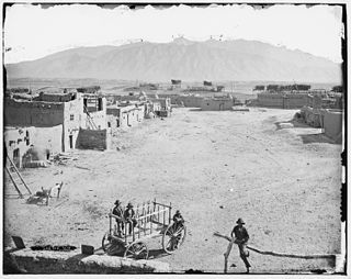
The Tiguex War was the first named war between Europeans and Native Americans in what is now part of the United States. The war took place in New Spain, during the colonization of Nuevo México. It was fought in the winter of 1540-41 by the expedition of Francisco Vázquez de Coronado against the twelve or thirteen Pueblos of what would become the Tiguex Province of Nuevo México. These villages were along both sides of the Rio Grande, north and south of present-day Bernalillo, New Mexico.

<span class="mw-page-title-main">Sandia Pueblo</span> Federally recognized Indian tribe of the United States

Sandia Pueblo is a federally recognized tribe of Native American Pueblo people inhabiting a 101-square-kilometre (40 sq mi) reservation of the same name in the eastern Rio Grande Rift of central New Mexico. It is one of 19 of New Mexico's Native American pueblos, considered one of the state's Eastern Pueblos. The population was 427 as of the 2010 census. The people are traditionally Tiwa speakers, a language of the Tanoan group, although retention of the traditional language has waned with later generations. They have a tribal government that operates Sandia Casino, Bien Mur Indian Market Center, and Sandia Lakes Recreation Area, as well as representing the will of the Pueblo in business and political matters.

<span class="mw-page-title-main">Rio Rancho, New Mexico</span> City in New Mexico, United States

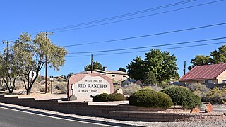
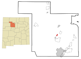
Rio Rancho is the largest and most populous city in Sandoval County, part of the expansive Albuquerque metropolitan area, in the U.S. state of New Mexico. A small portion of the city extends into northern Bernalillo County.

<span class="mw-page-title-main">Laguna Pueblo</span> Native American Pueblo tribe

The Pueblo of Laguna, New Mexico is a federally recognized tribe of Native American Pueblo people in west-central New Mexico, near the city of Albuquerque, in the United States. Part of the Laguna territory is included in the Albuquerque metropolitan area, chiefly around Laguna's Route 66 Resort and Casino. The name, Laguna, is Spanish and derives from the lake on their reservation. This body of water was formed by an ancient dam that was constructed by the Laguna people. After the Pueblo Revolt of 1680–1696, the Mission San José de la Laguna was erected by the Spanish at the old pueblo and finished around July 4, 1699.

<span class="mw-page-title-main">Albuquerque–Santa Fe–Los Alamos combined statistical area</span> Combined statistical area in New Mexico, United States

The Albuquerque–Santa Fe–Los Alamos combined statistical area is made up of eight counties in north central New Mexico. The combined statistical area consists of the Albuquerque and Santa Fe metropolitan statistical areas, and the Las Vegas, Los Alamos, and Española micropolitan statistical areas. The 2013 delineations included the Grants micropolitan statistical area, but it was removed in the 2018 revisions. As of the 2020 census, the CSA had a population of 1,162,523. Roughly 56% of New Mexico's residents live in this area. Prior to the 2013 redefinitions, the CSA consisted only of the Santa Fe metropolitan statistical area and the Española micropolitan statistical area. The total land area of the Albuquerque–Santa Fe–Las Vegas combined statistical area in the 2013 definition is 26,421 sq mi (68,430 km2).

Tigua, Tiguex, Tigüex, Tiwan, and Tiwesh may refer to:

<span class="mw-page-title-main">Coronado Historic Site</span> United States historic place

Coronado Historic Site is the Tiwa pueblo of Kuaua and a historic site that is part of the State-governed Museum of New Mexico system. It is located along U.S. Federal Route 550, 1 mile west of Bernalillo and 16 miles north of Albuquerque.

<span class="mw-page-title-main">Jemez Pueblo, New Mexico</span> CDP in New Mexico, United States

Jemez Pueblo is a census-designated place (CDP) in Sandoval County, New Mexico, United States. The population was 1,788 at the 2010 census. It is part of the Albuquerque Metropolitan Statistical Area.

References

  1. "Demographics". Albuquerque Business Expansion | Business Friendly Environment | Albuquerque Economic Development AED. Retrieved February 22, 2015.
  2. Casselle, T. (2010). Insiders' Guide® to Albuquerque. Insiders' Guide Series (in Kurdish). Insider's Guide. p. 34. ISBN   978-0-7627-6278-1 . Retrieved June 30, 2022.
  3. Lavender, D. (1984). The Southwest. University of New Mexico Press. p. 73. ISBN   978-0-8263-0736-1 . Retrieved June 30, 2022.
  4. Zimmerman, R.M. (2019). History Lover's Guide to Albuquerque, A. History and Guide Series. History Press. p. 23. ISBN   978-1-4671-4205-2 . Retrieved June 30, 2022.
  5. "Census data" (PDF). www.census.gov. 2010. Retrieved 2020-04-13.
  6. List of Metropolitan Statistical Areas
  7. Metcalf, Richard (March 1, 2008). "Mesa del Sol Reshapes Region". nreionline.com. Retrieved Mar 1, 2008.
  8. "Santolina Master Plan". www.bernco.gov.
  9. "U.S. Decennial Census". United States Census Bureau. Archived from the original on May 7, 2015. Retrieved May 28, 2013.
  10. "Cumulative Estimates of Resident Population Change and Rankings for Metropolitan Statistical Areas in the United States and Puerto Rico: April 1, 2010 to July 1, 2019" (PDF). United States Census Bureau. 2019. Retrieved May 31, 2020.
  11. "Explore Census Data". United States Census Bureau. Retrieved 26 May 2020.
  12. "Demographics". City of Albuquerque. Retrieved 2021-01-20.
  13. "New Mexico Department of Labor". Archived from the original on 2000-05-10. Retrieved 2020-04-13.