External links
-
 Central New Mexico travel guide from Wikivoyage
 - New Mexico Tourism Department Website for Central New Mexico
| | This New Mexico state location article is a stub. You can help Wikipedia by expanding it. |
Central New Mexico is the central region of the state of New Mexico. In the center of this region is Albuquerque, New Mexico, the largest city in the state.
The top seven largest cities in Central New Mexico are:
| | This New Mexico state location article is a stub. You can help Wikipedia by expanding it. |

New Mexico is a state in the Southwestern United States. It is one of the Mountain States of the southern Rocky Mountains, sharing the Four Corners region of the western U.S. with Utah, Colorado, and Arizona, and bordering Texas to the east and southeast, Oklahoma to the northeast, and the Mexican states of Chihuahua and Sonora to the south. New Mexico's largest city is Albuquerque, and its state capital is Santa Fe, which is the oldest state capital in the U.S., being founded in 1610 as the government seat of Nuevo México in New Spain.

Albuquerque, abbreviated ABQ, is the most populous city in the U.S. state of New Mexico. Its nicknames, The Duke City and Burque, both reference its founding in 1706 as La Villa de Alburquerque by Nuevo México governor Francisco Cuervo y Valdés. Named in honor of the Viceroy of New Spain, the 10th Duke of Alburquerque, the city was an outpost on El Camino Real linking Mexico City to the northernmost territories of New Spain.
Bernalillo County is the most populous county in the U.S. state of New Mexico. As of the 2020 census, the population was 676,444. The county seat, Albuquerque, is the most populous city in New Mexico.

The Southwestern United States, also known as the American Southwest or simply the Southwest, is a geographic and cultural region of the United States that generally includes Arizona, New Mexico, and adjacent portions of California, Colorado, Nevada, Oklahoma, Texas, and Utah. The largest cities by metropolitan area are Los Angeles, Phoenix, Las Vegas, Salt Lake City, El Paso, Albuquerque, Denver and Tucson. Before 1848, in the historical region of Santa Fe de Nuevo México as well as parts of Alta California and Coahuila y Tejas, settlement was almost non-existent outside of Nuevo México's Pueblos and Spanish or Mexican municipalities. Much of the area had been a part of New Spain and Mexico until the United States acquired the area through the Treaty of Guadalupe Hidalgo in 1848 and the smaller Gadsden Purchase in 1854.

The Mountain Time Zone of North America keeps time by subtracting seven hours from Coordinated Universal Time (UTC) when standard time (UTC−07:00) is in effect, and by subtracting six hours during daylight saving time (UTC−06:00). The clock time in this zone is based on the mean solar time at the 105th meridian west of the Greenwich Observatory. In the United States, the exact specification for the location of time zones and the dividing lines between zones is set forth in the Code of Federal Regulations at 49 CFR 71.

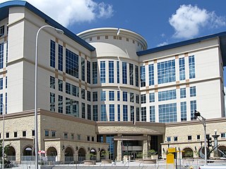
The Old Albuquerque High School is the historic former campus of Albuquerque High School in Albuquerque, New Mexico. It is located in the Huning Highlands neighborhood and is protected by the city as a historic landmark. It is located on the northeast corner of Central and Broadway NE, at the center of an area that has become known as East Downtown or EDo. The campus comprises five buildings, the oldest of which was built in 1914. After the school moved to a new location in 1974, the old buildings were left abandoned for decades before being renovated as loft apartments in the early 21st century. Old Albuquerque High was added to the New Mexico State Register of Cultural Properties in 1977.

Northern New Mexico in cultural terms usually refers to the area of heavy-Spanish settlement in the north-central part of New Mexico. However, New Mexico state government also uses the term to mean the northwest and north central, but to exclude both the northeastern high plains counties and Sandoval County. The five largest cities in Northern New Mexico are: Santa Fe, Las Vegas, Española, Los Alamos, and Raton.

The Alvarado Transportation Center (ATC) is a multimodal transit hub located at 100 1st Street SW in Downtown Albuquerque, New Mexico. The complex was built as a hub for Albuquerque's regional transit system and as a replacement for Albuquerque's previous bus depot and train station. The center serves ABQ RIDE, Amtrak, Greyhound Lines, and the New Mexico Rail Runner Express commuter rail line.
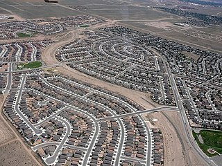
Rio Rancho is the most populous and only city in Sandoval County, part of the expansive Albuquerque metropolitan area, in the U.S. state of New Mexico. A small portion of the city extends into northern Bernalillo County.

Albuquerque is the primary media hub of the US state of New Mexico, which includes Santa Fe and Las Cruces. The vistas and adobe architecture of New Mexico are a major backdrop of Western fiction and the Western genre. The media of Albuquerque and New Mexico has international influence, including important production studios, newspapers, magazines, radio and television studios.

The Albuquerque Metropolitan Statistical Area, sometimes referred to as Tiguex, is a metropolitan area in central New Mexico centered on the city of Albuquerque. The metro comprises four counties: Bernalillo, Sandoval, Torrance, and Valencia. As of the 2010 United States Census, the MSA had a population of 887,077. The population is estimated to be 923,630 as of July 1, 2020, making Greater Albuquerque the 61st-largest MSA in the nation. The Albuquerque MSA forms a part of the larger Albuquerque–Santa Fe–Las Vegas combined statistical area with a 2020 estimated population of 1,165,181, ranked 49th-largest in the country.

Interstate 40 (I-40), a major east–west route of the Interstate Highway System, runs east–west through Albuquerque in the US state of New Mexico. It is the direct replacement for the historic U.S. Highway 66 (US 66).

New Mexico has a long history of wine production, within American wine, especially along the Rio Grande, from its capital Santa Fe, the city of Albuquerque with its surrounding metropolitan area, and in valleys like the Mesilla and the Mimbres River valleys. In 1629, Franciscan friar García de Zúñiga and a Capuchín monk named Antonio de Arteaga planted the first wine grapes in Santa Fe de Nuevo México, in what would become the modern Middle Rio Grande Valley AVA. Today, wineries exist in the aforementioned Middle Rio Grande Valley, as well as the Mesilla Valley AVA and the Mimbres Valley AVA.

With a total area of 121,590 square miles (314,900 km2), New Mexico is the fifth-largest state, after Alaska, Texas, California, and Montana. Its eastern border lies along 103°W longitude with the state of Oklahoma, and 2.2 miles west of 103°W longitude with Texas. On the southern border, Texas makes up the eastern two-thirds, while the Mexican states of Chihuahua and Sonora make up the western third, with Chihuahua making up about 90% of that. The western border with Arizona runs along the 109° 03'W longitude. The southwestern corner of the state is known as the Bootheel. The 37°N parallel forms the northern boundary with Colorado. The states of New Mexico, Colorado, Arizona, and Utah come together at the Four Corners in New Mexico's northwestern corner. Its surface water area is about 292 square miles (760 km2).

Oil and gas production, tourism, and federal government spending are important drivers of New Mexico's economy. The state government has an elaborate system of tax credits and technical assistance to promote job growth and business investment, especially in new technologies.
The 2014 United States House of Representatives elections in New Mexico were held on Tuesday, November 4, 2014 to elect the three U.S. representatives from the state of New Mexico, one from each of the state's three congressional districts. The elections coincided with the elections of other federal and state offices, including the Governor of New Mexico and a United States Senator.

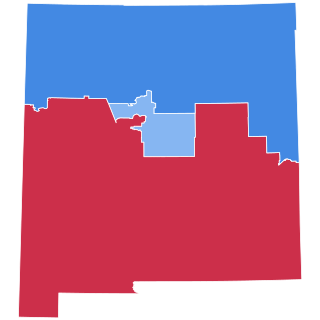
The 2016 United States presidential election in New Mexico was held on Tuesday, November 8, 2016, as part of the 2016 United States presidential election in which all 50 states plus the District of Columbia participated. New Mexico voters chose electors to represent them in the Electoral College via a popular vote, pitting the Republican Party's nominee, businessman Donald Trump, and running mate Indiana Governor Mike Pence against Democratic Party nominee, former Secretary of State Hillary Clinton, and her running mate Virginia Senator Tim Kaine. New Mexico has five electoral votes in the Electoral College.
The history of Albuquerque, New Mexico dates back up to 12,000 years, beginning with the presence of Paleo-Indian hunter-gatherers in the region. Gradually, these nomadic people adopted a more settled, agricultural lifestyle and began to build multi-story stone or adobe dwellings now known as pueblos by 750 CE. The Albuquerque area was settled by the Tiwa people beginning around 1250. By the 1500s, there were around 20 Tiwa pueblos along a 60-mile (97 km) stretch of the middle Rio Grande valley. The region was visited by Spanish conquistadores beginning with the expedition of Francisco Vázquez de Coronado in 1540–41, and began to be settled by Spanish colonists after the expedition of Juan de Oñate in 1598. By 1680, 17 Spanish estancias were reported along the Camino Real in the Albuquerque area.
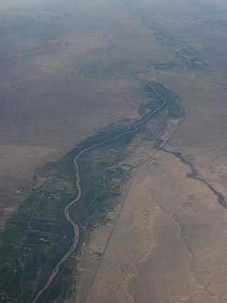
The Rio Grande Valley is the river valley carved out by the Rio Grande as it flows through the American Southwest and northeastern Mexico, forming a part of the border region. In the US state of New Mexico, the river flows mostly north to south, and forms a valley near Cochiti Pueblo to the state line near El Paso, Texas along the floors of the large sedimentary basins of the Rio Grande Rift, and includes the narrow sections between the basins. It has been historically settled first by the Pueblo peoples, the Spanish, the Mexicans, and finally Anglo-Americans. As the largest river in the state, some of its most populous cities are located wholly or partially in the valley, including Albuquerque, New Mexico's largest city.