Worcester County is the easternmost county of the U.S. state of Maryland. As of the 2020 census, the population was 52,460. Its county seat is Snow Hill.
In the United States, a metropolitan statistical area (MSA) is a geographical region with a relatively high population density at its core and close economic ties throughout the region. Such regions are not legally incorporated as a city or town would be and are not legal administrative divisions like counties or separate entities such as states. As a result, sometimes the precise definition of a given metropolitan area will vary between sources. The statistical criteria for a standard metropolitan area were defined in 1949 and redefined as a metropolitan statistical area in 1983.

The Blacksburg-Christiansburg Metropolitan Statistical Area, formerly the Blacksburg-Christiansburg-Radford Metropolitan Statistical Area, is a Metropolitan Statistical Area (MSA) as defined by the United States Office of Management and Budget (OMB) located in the New River Valley of Southwest Virginia. As of the 2020 census, the MSA had a population of 181,863.

The Lynchburg Metropolitan Statistical Area is a United States Metropolitan Statistical Area (MSA) in the state of Virginia, as defined by the Office of Management and Budget (OMB) as of June 2003. As of the 2000 census, the MSA had a population of 228,616. In 2009 this was estimated to have risen to 247,447; as of 2016, the Lynchburg MSA was estimated to have a population of 260,320, making it the fifth-largest metro area in the state.

The Beaumont–Port Arthur metropolitan statistical area is defined by the United States Census Bureau as a three-county region in Southeast Texas. The metropolitan area shares borders with the Houston–The Woodlands–Sugar Land metropolitan area to the west and the Lake Charles metropolitan area in the U.S. state of Louisiana to the east. The area is also known as the Golden Triangle. The "golden" refers to the wealth that came from the Spindletop oil strike near Beaumont in 1901, and "triangle" refers to the area among the cities of Beaumont, Port Arthur, and Orange.
The Charleston Metropolitan Statistical Area, as defined by the United States Census Bureau, is an area consisting of three counties in West Virginia, anchored by the city of Charleston. It is the largest metropolitan area entirely within the state of West Virginia. The Huntington Metro Area adds to the Charleston–Huntington, WV-OH-KY CSA and spans three states, while the core county of the Charleston area, Kanawha County, is more populous than the West Virginia portion of the Huntington area.
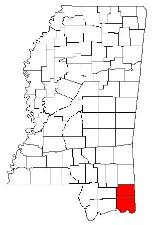
The Pascagoula Metropolitan Statistical Area was a metropolitan area in the southeastern corner of Mississippi that covered two counties - Jackson and George. As of the 2000 census, the MSA had a population of 150,564. The area was significantly impacted by Hurricane Katrina in 2005. A July 1, 2009 estimate placed the population at 155,603. Prior to the hurricane, the area had experienced steady population growth. It was also part of the larger Gulfport-Biloxi-Pascagoula Combined Statistical Area.

The Logan Metropolitan Statistical Area, as defined by the United States Census Bureau, is an area consisting of two counties – one in Utah and one in Idaho, anchored by the city of Logan. As of the 2010 census, the MSA had a population of 125,442. As of the 2020 Census, the population had risen to 147,908, and further expanded to an estimated 155,362 as of 2022. The Logan metropolitan area is colloquially called Cache Valley, where most of the population resides.

The Rockford Metropolitan Statistical Area, as defined by the United States Census Bureau, is an area consisting of four counties in north-central Illinois, anchored by the city of Rockford. As of the 2010 census, the MSA had a population of 349,431. The Rockford MSA abuts the southern portions of the Janesville-Beloit MSA and the Chicago MSA. It forms the main part of the larger Rockford–Freeport–Rochelle Combined Statistical Area.

The Manhattan–Junction City Combined Statistical Area, as defined by the United States Census Bureau, is an area consisting of three counties in northeastern Kansas, anchored by the city of Manhattan. It was upgraded from a Micropolitan Statistical Area (μSA) to a Metropolitan Statistical Area (MSA) by the Office of Management and Budget on November 20, 2008. It was changed from a Metropolitan Statistical Area (MSA) to a Combined Statistical Area (CSA) by the Office of Management and Budget on February 28, 2013.

The city of Portland, Maine, is the hub city of a metropolitan area in southern Maine. The region is commonly known as Greater Portland or the Portland metropolitan area. For statistical purposes, the U.S. federal government defines three different representations of the Portland metropolitan area. The Portland–South Portland, Maine, metropolitan statistical area is a region consisting of three counties in Maine, anchored by the city of Portland and the smaller city of South Portland. As of the 2020 census, the MSA had a population of 551,740. A larger combined statistical area (CSA), the Portland–Lewiston–South Portland combined statistical area, is defined as the combination of this metropolitan statistical area (MSA) with the adjacent Lewiston–Auburn MSA. The CSA comprises four counties in southern Maine. The Portland–South Portland metropolitan New England city and town area is defined on the basis of cities and towns rather than entire counties. It consists of most of Cumberland and York counties plus the town of Durham in Androscoggin County. The Greater Portland area has emerged as an important center for the creative economy, which is also bringing gentrification.

The Montgomery, Alabama Metropolitan Statistical Area is a metropolitan area in central Alabama. As of 2020, the MSA had a population of 386,047, ranking it 142nd among United States Metropolitan Statistical Areas. That number is up +3.07% from the 2010 census number of 374,536.

The Wichita, Kansas Metropolitan Statistical Area, as defined by the United States Office of Management and Budget, is an area consisting of four counties in south central Kansas, its only principal city is Wichita and its only central county is Sedgwick County. As of the 2013 American Community Survey, the MSA had a population of 637,989.

The Goldsboro Metropolitan Statistical Area, as defined by the United States Census Bureau, is an area consisting of one county – Wayne – in North Carolina, anchored by the city of Goldsboro. As of the 2000 census, the MSA had a population of 113,329.

The Paducah, KY–IL Metropolitan Statistical Area, as defined by the United States Census Bureau, is an area consisting of five counties – three in the Jackson Purchase region of Kentucky, a fourth Kentucky county bordering the Purchase, and one in Southern Illinois – anchored by the city of Paducah, Kentucky. The Paducah KY-IL Micropolitan Statistical Area was upgraded to Metropolitan Statistical Area (MSA) status on July 21, 2023, by the Office of Management and Budget.. Carlisle County, Kentucky, was added to the area following the 2020 Census of the Population. The total MSA population from the 2020 United States Census was 103,486.

The Dothan–Enterprise–Ozark Combined Statistical Area was a CSA made up of five counties in the southeastern corner of the U.S. state of Alabama. The once statistical area includes one metropolitan area and originally one micropolitan area which then was split off as two. As of the 2010 census, the CSA had a population of 245,838. Currently an updated area called the Dothan-Ozark Combined Statistical area is used instead and Enterprise micropolitan area is now split as its own statistical area.

The Columbus metropolitan area, officially the Columbus metropolitan statistical area, and colloquially known as the Chattahoochee Valley, is a metropolitan statistical area consisting of six counties in the U.S. state of Georgia and one county in Alabama, anchored by the city of Columbus.
The Mayagüez Metropolitan Statistical Area is a United States Census Bureau defined Metropolitan Statistical Area (MSA) in west central Puerto Rico. A July 1, 2009 Census Bureau estimate placed the population at 109,842, a 4.53% decrease from the 2000 census figure of 115,048.
The Kokomo Metropolitan Statistical Area, as defined by the United States Census Bureau, is an area consisting of Howard County in Indiana. Howard County had a population estimate of 83,831 in 2023. Kokomo is also the principal city of the area known as North Central Indiana, the area around Kokomo with economic ties. The six county area including Cass, Clinton, Fulton, Howard, Miami, and Tipton counties had population of 228,331 people in 2010.

The Rome Metropolitan Statistical Area in the U.S. state of Georgia, as defined by the United States Census Bureau, is an area consisting of one county – Floyd – in Northwest Georgia. As of the 2000 census, the MSA had a population of 90,565.