Mardela Springs, Maryland

Last updated

Mardela Springs, Maryland
Mardela Springs MD1.jpg
Flag of Mardela Springs, Maryland.png
Seal of Mardela Springs, Maryland.png
Wicomico County Maryland Incorporated and Unincorporated areas Mardela Springs Highlighted.svg
Location of Mardela Springs, Maryland
Coordinates: 38°27′36″N75°45′21″W / 38.46000°N 75.75583°W / 38.46000; -75.75583
Country United States
State Maryland
County Wicomico
Incorporated 1906 [1]
Area
[2]
  Total0.41 sq mi (1.07 km2)
  Land0.41 sq mi (1.05 km2)
  Water0.01 sq mi (0.02 km2)
Elevation
26 ft (8 m)
Population
 (2020)
  Total357
  Density879.31/sq mi (339.13/km2)
Time zone UTC-5 (Eastern (EST))
  Summer (DST) UTC-4 (EDT)
ZIP code
21837
Area code(s) 410, 443
FIPS code 24-50525
GNIS feature ID0590738
Website mardelasprings.org

Mardela Springs is a town in Wicomico County, Maryland, United States. The population was 357 at the 2010 census. It is included in the Salisbury, Maryland-Delaware Metropolitan Statistical Area.

Contents

History

The area around Mardela Springs was home to indigenous tribes. Europeans brought fur trading to the area. Mineral springs attracted tourists in the 19th century and a spring water company. [3]

Geography

Mardela Springs is located at 38°27′36″N75°45′21″W / 38.46000°N 75.75583°W / 38.46000; -75.75583 (38.460098, -75.755785). [4]

According to the United States Census Bureau, the town has a total area of 0.40 square miles (1.04 km2), of which 0.39 square miles (1.01 km2) is land and 0.01 square miles (0.03 km2) is water. [5]

Climate

The climate in this area is characterized by hot, humid summers and generally mild to cool winters. According to the Köppen Climate Classification system, Mardela Springs has a humid subtropical climate, abbreviated "Cfa" on climate maps. [6]

Demographics

Historical population
CensusPop.Note
1930 370
1940 41813.0%
1950 4282.4%
1960 380−11.2%
1970 356−6.3%
1980 320−10.1%
1990 36012.5%
2000 3641.1%
2010 347−4.7%
2020 3572.9%
U.S. Decennial Census [7]

2010 census

As of the census [8] of 2010, there were 347 people, 134 households, and 97 families living in the town. The population density was 889.7 inhabitants per square mile (343.5/km2). There were 160 housing units at an average density of 410.3 per square mile (158.4/km2). The racial makeup of the town was 88.2% White, 6.9% African American, 0.6% Asian, 0.6% Pacific Islander, 0.6% from other races, and 3.2% from two or more races. Hispanic or Latino of any race were 2.3% of the population.

There were 134 households, of which 36.6% had children under the age of 18 living with them, 53.7% were married couples living together, 14.2% had a female householder with no husband present, 4.5% had a male householder with no wife present, and 27.6% were non-families. 22.4% of all households were made up of individuals, and 11.9% had someone living alone who was 65 years of age or older. The average household size was 2.59 and the average family size was 3.00.

The median age in the town was 37.9 years. 27.1% of residents were under the age of 18; 6.7% were between the ages of 18 and 24; 27.9% were from 25 to 44; 25.3% were from 45 to 64; and 13% were 65 years of age or older. The gender makeup of the town was 50.7% male and 49.3% female.

2000 census

Barren Creek Springs springhouse Barren Creek Springs Mardela Springs MD1.jpg
Barren Creek Springs springhouse

As of the census [9] of 2000, there were 364 people, 135 households, and 93 families living in the town. The population density was 1,009.2 inhabitants per square mile (389.7/km2). There were 159 housing units at an average density of 440.8 per square mile (170.2/km2). The racial makeup of the town was 90.93% White, 5.49% African American, 0.55% Native American, 1.92% from other races, and 1.10% from two or more races. Hispanic or Latino of any race were 4.40% of the population.

There were 135 households, out of which 37.8% had children under the age of 18 living with them, 52.6% were married couples living together, 7.4% had a female householder with no husband present, and 30.4% were non-families. 23.0% of all households were made up of individuals, and 12.6% had someone living alone who was 65 years of age or older. The average household size was 2.67 and the average family size was 3.15.

In the town, the population was spread out, with 29.1% under the age of 18, 8.2% from 18 to 24, 30.2% from 25 to 44, 20.6% from 45 to 64, and 11.8% who were 65 years of age or older. The median age was 34 years. For every 100 females, there were 95.7 males. For every 100 females age 18 and over, there were 85.6 males.

The median income for a household in the town was $37,500, and the median income for a family was $46,250. Males had a median income of $35,125 versus $20,000 for females. The per capita income for the town was $17,580. About 6.8% of families and 6.9% of the population were below the poverty line, including 5.4% of those under age 18 and 2.9% of those age 65 or over.

Notable person

Related Research Articles

<span class="mw-page-title-main">Coffee Springs, Alabama</span> Town in Alabama, United States

Coffee Springs is a town in Geneva County, Alabama, United States. It was incorporated in 1900, and it is considered to be a part of the Dothan, Alabama Metropolitan Statistical Area. At the 2010 census the population was 228, down from 251.

<span class="mw-page-title-main">Double Springs, Alabama</span> City in and county seat of Winston County, Alabama

Double Springs is a town in Winston County, Alabama, United States. The city is the county seat of Winston County. The county seat was initially located at Houston, but by referendum in 1883, Double Springs prevailed and it was removed to there. It was incorporated on May 17, 1943. At the 2010 census the population was 1,083, up from 1,003 in 2000.

Upper Grand Lagoon is a census-designated place (CDP) in Bay County, Florida, United States. The population was 13,963 at the 2010 census. It is part of the Panama City–Lynn Haven–Panama City Beach Metropolitan Statistical Area.

<span class="mw-page-title-main">Hartford, Maine</span> Town in the state of Maine, United States

Hartford is a town in Oxford County, Maine, United States. Hartford is included in the Lewiston-Auburn, Maine metropolitan New England City and Town Area. The population was 1,203 at the 2020 census.

<span class="mw-page-title-main">Westernport, Maryland</span> Town in Maryland, United States

Westernport is a town in Allegany County, Maryland, United States, along the Georges Creek Valley. It is part of the Cumberland, MD-WV Metropolitan Statistical Area. The population was 1,888 at the 2010 census.

<span class="mw-page-title-main">Denton, Maryland</span> Town in Maryland

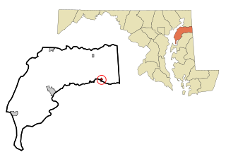
Denton is a town in Caroline County, Maryland, United States. The population of Denton was 4,418 as of the 2010 United States Census, and it is the county seat of Caroline County.

<span class="mw-page-title-main">Goldsboro, Maryland</span> Town in Maryland

Goldsboro is a town in Caroline County, Maryland, United States. William James Yeager is the current mayor. The population was 246 at the 2010 United States Census. The zip code is 21636. First known as Oldtown, it was renamed in 1870 for the prominent Goldsborough family who owned land in the area. Castle Hall was listed on the National Register of Historic Places in 1975.

<span class="mw-page-title-main">Greensboro, Maryland</span> Town in Maryland

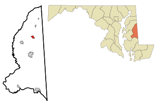
Greensboro is a town located on the banks of the Choptank River in Caroline County, Maryland, United States. The population was 1,931 at the 2010 United States Census. The ZIP code is 21639. The primary phone exchange is 482 and the area code is 410. The town is served by Maryland Routes 480 and 313.

<span class="mw-page-title-main">Hillsboro, Maryland</span> Town in Maryland

Hillsboro is a town in Caroline County, Maryland, United States. The population was 161 at the 2010 United States Census. Daffin House and St. Paul's Episcopal Church were listed on the National Register of Historic Places in 1975.

<span class="mw-page-title-main">Preston, Maryland</span> Town in Maryland

Preston is a town in Caroline County, Maryland, United States. The population was 719 at the 2010 census.

<span class="mw-page-title-main">Grantsville, Maryland</span> Town in Maryland, United States

Grantsville is a town in the northern part of Garrett County, Maryland, United States, near the Pennsylvania border. The population was 968 as of the 2020 census.

<span class="mw-page-title-main">Ashton-Sandy Spring, Maryland</span> Census-designated place in Maryland, United States

Ashton-Sandy Spring is a census-designated place (CDP) in Montgomery County, Maryland, United States. The CDP is designated to include the two unincorporated communities of Ashton and Sandy Spring, as well as the smaller community of Brinklow. It had a population of 5,746 as of the 2020 census.

<span class="mw-page-title-main">Hancock, Maryland</span> Town in Maryland, United States

Hancock is a town in Washington County, Maryland, United States. The population was 1,557 at the 2020 census. The Western Maryland community is notable for being located at the narrowest part of the state. The north–south distance from the Pennsylvania state line to the West Virginia state line is only 1.8 miles (2.9 km) at Hancock.

<span class="mw-page-title-main">Willards, Maryland</span> Town in Maryland, United States

Willards is a town in Wicomico County, Maryland, United States. The population was 958 at the 2010 census. It is included in the Salisbury, Maryland-Delaware Metropolitan Statistical Area.

<span class="mw-page-title-main">Ferrysburg, Michigan</span> City in Michigan, United States

Ferrysburg is a city in Ottawa County in the U.S. state of Michigan. The population was 2,892 at the 2010 census.

<span class="mw-page-title-main">Tieton, Washington</span> City in Washington, United States

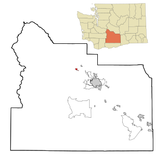
Tieton is a city in Yakima County, Washington, United States. The population was 1,389 at the 2020 census.

<span class="mw-page-title-main">Belington, West Virginia</span> City in West Virginia

Belington is a town in Barbour County, West Virginia, United States, situated along the Tygart Valley River. The population was 1,804 as of the 2020 census.

<span class="mw-page-title-main">Beech Bottom, West Virginia</span> Village in West Virginia, United States

Beech Bottom is a village in Brooke County, West Virginia, United States, situated along the Ohio River. The population was 523 at the 2010 census. It is part of the Weirton–Steubenville metropolitan area.

<span class="mw-page-title-main">Smithfield, West Virginia</span> Town in West Virginia, United States

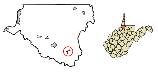
Smithfield is a town in Wetzel County, West Virginia, United States. The population was 103 at the 2020 census.

<span class="mw-page-title-main">Millington, Maryland</span> Town in Maryland, United States

Millington is a town in Kent and Queen Anne's counties in the U.S. state of Maryland. The population was 642 at the 2010 census. Millington is the head of navigation for the Chester River.

References

  1. "Mardela Springs". Maryland Manual. Retrieved June 28, 2017.
  2. "2020 U.S. Gazetteer Files". United States Census Bureau. Retrieved April 26, 2022.
  3. "History – Mardela Springs". mardelasprings.org.
  4. "US Gazetteer files: 2010, 2000, and 1990". United States Census Bureau. February 12, 2011. Retrieved April 23, 2011.
  5. "US Gazetteer files 2010". United States Census Bureau. Archived from the original on January 25, 2012. Retrieved January 25, 2013.
  6. "Mardela Springs, Maryland Köppen Climate Classification (Weatherbase)". Weatherbase.
  7. "Census of Population and Housing". Census.gov. Retrieved June 4, 2015.
  8. "U.S. Census website". United States Census Bureau . Retrieved January 25, 2013.
  9. "U.S. Census website". United States Census Bureau . Retrieved January 31, 2008.