Fruitland, Maryland

Last updated

Fruitland, Maryland
Flag of Fruitland, Maryland.png
Fruitland maryland seal.png
Wicomico County Maryland Incorporated and Unincorporated areas Fruitland Highlighted.svg
Location of Fruitland, Maryland
Coordinates: 38°19′25″N75°37′10″W / 38.32361°N 75.61944°W / 38.32361; -75.61944
Country United States
State Maryland
County Wicomico
Incorporated1947
Government
  Type Council–manager government
   City Manager Marc Henderson
   City Council
Member List
Area
[1]
  Total3.86 sq mi (10.00 km2)
  Land3.85 sq mi (9.98 km2)
  Water0.01 sq mi (0.02 km2)
Elevation
36 ft (11 m)
Population
 (2020)
  Total5,534
  Density1,435.54/sq mi (554.32/km2)
Time zone UTC-5 (Eastern (EST))
  Summer (DST) UTC-4 (EDT)
ZIP code
21826
Area code(s) 410, 443
FIPS code 24-30950
GNIS feature ID0584531
Website www.cityoffruitland.com

Fruitland is a city in Wicomico County, Maryland, United States. The population was 4,866 at the 2010 census. It is included in the Salisbury, Maryland-Delaware Metropolitan Statistical Area.

Contents

Geography

Fruitland is located at 38°19′25″N75°37′10″W / 38.32361°N 75.61944°W / 38.32361; -75.61944 (38.323555, -75.619557). [2]

According to the United States Census Bureau, the city has a total area of 3.79 square miles (9.82 km2), of which 3.78 square miles (9.79 km2) is land and 0.01 square miles (0.03 km2) is water. [3]

Demographics

Historical population
CensusPop.Note
1950 1,028
1960 1,14711.6%
1970 2,315101.8%
1980 2,69416.4%
1990 3,51130.3%
2000 3,7747.5%
2010 4,86628.9%
2020 5,53413.7%

The median income for a household in the city was $34,468, and the median income for a family was $36,181. Males had a median income of $28,495 versus $21,127 for females. The per capita income for the city was $17,774. About 15.2% of families and 18.3% of the population were below the poverty line, including 22.1% of those under age 18 and 16.3% of those age 65 or over.

2010 census

As of the census [4] of 2010, there were 4,866 people, 1,840 households, and 1,223 families residing in the city. The population density was 1,287.3 inhabitants per square mile (497.0/km2). There were 2,045 housing units at an average density of 541.0 per square mile (208.9/km2). The racial makeup of the city was 62.0% White, 30.3% African American, 0.6% Native American, 3.1% Asian, 1.4% from other races, and 2.6% from two or more races. Hispanic or Latino of any race were 3.3% of the population.

There were 1,840 households, of which 37.3% had children under the age of 18 living with them, 43.0% were married couples living together, 18.4% had a female householder with no husband present, 5.1% had a male householder with no wife present, and 33.5% were non-families. 23.2% of all households were made up of individuals, and 7.9% had someone living alone who was 65 years of age or older. The average household size was 2.64 and the average family size was 3.11.

The median age in the city was 32.5 years. 26.6% of residents were under the age of 18; 12.1% were between the ages of 18 and 24; 27.4% were from 25 to 44; 23.6% were from 45 to 64; and 10.2% were 65 years of age or older. The gender makeup of the city was 46.6% male and 53.4% female.

Population by Race in Fruitland Maryland (2010)
RacePopulation % of Total
Total4,866100
White 3,01862
African American 1,47230
Hispanic 1603
Asian 1503
Two or More Races 1282
[5]

Schools

Fruitland Intermediate School Fruitland intermediate school.jpg
Fruitland Intermediate School

Fruitland Primary School (K-2) and Fruitland Intermediate School (3-5) are within Fruitland's city limits and are operated by Wicomico County Public Schools, which serve the city and surrounding area. Students from Fruitland schools feed into Bennett Middle School (6-8) and then into either James M. Bennett High School or Parkside High School, all of which are located in Salisbury.

Climate

Climate is characterized by relatively high temperatures and evenly distributed precipitation throughout the year. The Köppen Climate Classification subtype for this climate is "Cfa" (Humid Subtropical Climate). [6]

Climate data for Fruitland, Maryland
MonthJanFebMarAprMayJunJulAugSepOctNovDecYear
Average high °C (°F)8
(47)
9
(48)
14
(57)
19
(67)
24
(76)
29
(84)
31
(87)
30
(86)
27
(80)
21
(70)
16
(60)
9
(49)
20
(68)
Average low °C (°F)−2
(28)
−2
(29)
2
(36)
7
(44)
12
(53)
17
(62)
19
(67)
19
(66)
15
(59)
9
(48)
4
(39)
−1
(31)
8
(47)
Average precipitation mm (inches)94
(3.7)
81
(3.2)
110
(4.2)
89
(3.5)
89
(3.5)
94
(3.7)
110
(4.2)
140
(5.4)
99
(3.9)
84
(3.3)
79
(3.1)
86
(3.4)
1,140
(44.9)
Source: Weatherbase [7]

Related Research Articles

<span class="mw-page-title-main">Dorchester County, Maryland</span> County in Maryland, United States

<span class="mw-page-title-main">Wicomico County, Maryland</span> County in Maryland, United States

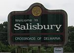
Wicomico County is located in the southeastern part of the U.S. state of Maryland, on the Delmarva Peninsula. As of the 2020 census, the population was 103,588. The county seat is Salisbury. The county was named for the Wicomico River, which in turn derives its name from the Algonquian language words wicko mekee, meaning "a place where houses are built," apparently referring to a Native American town on the banks. The county is included in the Salisbury, MD-DE Metropolitan Statistical Area.

<span class="mw-page-title-main">Worcester County, Maryland</span> County in Maryland, United States

Worcester County is the easternmost county of the U.S. state of Maryland. As of the 2020 census, the population was 52,460. Its county seat is Snow Hill.

<span class="mw-page-title-main">Brookwood, Alabama</span> City in Alabama, United States

Brookwood is a city in Tuscaloosa County, Alabama, United States. It incorporated in September 1977. As of the 2020 census, the population of the town is 2,504.

<span class="mw-page-title-main">Benton, Arkansas</span> City in Arkansas, United States

Benton is a city in and the county seat of Saline County, Arkansas, United States and a suburb of Little Rock. It was established in 1837. At the 2010 census, the city had a population of 30,681. In 2019 the population was estimated at 36,820. It is part of the Little Rock–North Little Rock–Conway Metropolitan Statistical Area. The city of Benton, first settled in 1833 and named after Missouri Senator Thomas Hart Benton, was formally chartered in 1836 when Arkansas became a state.

<span class="mw-page-title-main">Bethel, Delaware</span> Town in Delaware, United States

Bethel is a town in Sussex County, Delaware, United States. According to 2010 Census Bureau figures, the population of the town is 171. It is part of the Salisbury, Maryland-Delaware Metropolitan Statistical Area.

<span class="mw-page-title-main">Nashville, Georgia</span> City in Georgia, United States

Nashville is a city in and the county seat of Berrien County, Georgia, United States. The population was 7,029 at the 2022 census. It is called the "City of Dogwoods", as the tree grows in large numbers around the area.

<span class="mw-page-title-main">Delta, Louisiana</span> Village in Louisiana, United States

Delta is a village in Madison Parish, Louisiana, United States. The population was 232 at the 2020 census. It is part of the Tallulah Micropolitan Statistical Area.

<span class="mw-page-title-main">Converse, Louisiana</span> Village in Louisiana, United States

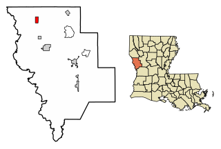
Converse is a village in Sabine Parish, Louisiana, United States. The population was 440 at the 2010 census.

<span class="mw-page-title-main">Potomac, Maryland</span> Census-designated place in Maryland, United States

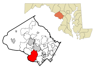
Potomac is an unincorporated community and census-designated place (CDP) in Montgomery County, Maryland. As of the 2020 census, it had a population of 47,018. It is named after the nearby Potomac River.

<span class="mw-page-title-main">Eden, Maryland</span> CDP in Maryland, United States

Eden is a census-designated place (CDP) in Somerset County, Maryland, United States. The Eden zip code (21822) also includes parts of Wicomico and Worcester counties. The population was 793 at the 2000 census. It is included in the Salisbury, Maryland-Delaware Metropolitan Statistical Area.

<span class="mw-page-title-main">Hancock, Maryland</span> Town in Maryland, United States

Hancock is a town in Washington County, Maryland, United States. The population was 1,557 at the 2020 census. The Western Maryland community is notable for being located at the narrowest part of the state. The north–south distance from the Pennsylvania state line to the West Virginia state line is only 1.8 miles (2.9 km) at Hancock.

<span class="mw-page-title-main">Delmar, Maryland</span> Town in Maryland, United States

Delmar is a town in Wicomico County, Maryland, United States. The population was 3,003 at the 2010 census. It is included in the Salisbury, Maryland-Delaware Metropolitan Statistical Area. When the population is added to Delmar, Delaware, the town's total population is 4,600.

<span class="mw-page-title-main">Mardela Springs, Maryland</span> Town in Maryland, United States

Mardela Springs is a town in Wicomico County, Maryland, United States. The population was 357 at the 2010 census. It is included in the Salisbury, Maryland-Delaware Metropolitan Statistical Area.

<span class="mw-page-title-main">Sharptown, Maryland</span> Town in Maryland, United States

Sharptown is a town in Wicomico County, Maryland, United States. The population was 651 at the 2010 census. It is included in the Salisbury, Maryland-Delaware Metropolitan Statistical Area.

<span class="mw-page-title-main">Chelsea, Michigan</span> City in Michigan, United States

Chelsea is a city in Washtenaw County in the U.S. state of Michigan. The population was 5,467 at the 2020 census.

<span class="mw-page-title-main">Drummond, Montana</span> Town in Montana, United States

Drummond is a town in Granite County, Montana, United States. The population was 272 at the 2020 census.

<span class="mw-page-title-main">Bowman, North Dakota</span> City in North Dakota, United States

Bowman is a city and county seat of Bowman County, North Dakota, United States. The population was 1,470 at the 2020 census.

<span class="mw-page-title-main">Loudon, Tennessee</span> City in Tennessee, United States

Loudon is a city in and the county seat of Loudon County, Tennessee, United States. Its population was 6,001 at the 2020 census. It is included in the Knoxville, Tennessee Metropolitan Statistical Area. The city is located in East Tennessee, southwest of Knoxville, on the Tennessee River. Fort Loudoun, the colonial era fort for which the city was named, is located several miles to the south in Monroe County.

<span class="mw-page-title-main">Knollwood, Texas</span> City in Texas, United States

Knollwood is a city in Grayson County, Texas, United States. The population was 432 at the 2010 census. It is part of the Sherman–Denison metropolitan statistical area.

References

  1. "2020 U.S. Gazetteer Files". United States Census Bureau. Retrieved April 26, 2022.
  2. "US Gazetteer files: 2010, 2000, and 1990". United States Census Bureau. February 12, 2011. Retrieved April 23, 2011.
  3. "US Gazetteer files 2010". United States Census Bureau. Archived from the original on July 2, 2012. Retrieved January 25, 2013.
  4. "U.S. Census website". United States Census Bureau . Retrieved January 25, 2013.
  5. "Fruitland Maryland Population Statistics". US Census Bureau. Retrieved June 9, 2014.
  6. Climate Summary for Fruitland, Maryland
  7. "Weatherbase.com". Weatherbase. 2013. Retrieved on August 7, 2013.