Whaleyville, Maryland

Last updated

Whaleyville, Maryland
CDP
Worcester County Maryland Incorporated and Unincorporated areas Whaleyville Highlighted.svg
Location of Whaleyville, Maryland
Coordinates: 38°23′47″N75°18′5″W / 38.39639°N 75.30139°W / 38.39639; -75.30139
CountryUnited States
State Maryland
County Worcester
Area
[1]
  Total1.01 sq mi (2.63 km2)
  Land1.01 sq mi (2.63 km2)
  Water0.00 sq mi (0.00 km2)
Elevation
30 ft (9 m)
Population
 (2020)
  Total192
  Density189.35/sq mi (73.13/km2)
Time zone UTC−5 (Eastern (EST))
  Summer (DST) UTC−4 (EDT)
ZIP code
21872
Area code(s) 410, 443
FIPS code 24-83746
GNIS feature ID0591697

Whaleyville is a census-designated place in Worcester County, Maryland, United States. The population was 149 at the 2010 census. It is part of the Salisbury, Maryland-Delaware Metropolitan Statistical Area.

Contents

Geography

Whaleyville is located at 38°23′47″N75°18′5″W / 38.39639°N 75.30139°W / 38.39639; -75.30139 (38.396470, 75.301292). [2]

According to the United States Census Bureau, the CDP has a total area of 1.0 square mile (2.6 km2), all land.

Demographics

Historical population
CensusPop.Note
2020 192
U.S. Decennial Census [3]

As of the census [4] of 2000, there were 124 people, 57 households, and 38 families residing in the CDP. The population density was 128.9 inhabitants per square mile (49.8/km2). There were 64 housing units at an average density of 66.5 per square mile (25.7/km2). The racial makeup of the CDP was 95.16% White, 2.42% African American, 2.42% from other races. Hispanic or Latino of any race were 2.42% of the population.

There were 57 households, out of which 22.8% had children under the age of 18 living with them, 52.6% were married couples living together, 12.3% had a female householder with no husband present, and 33.3% were non-families. 28.1% of all households were made up of individuals, and 17.5% had someone living alone who was 65 years of age or older. The average household size was 2.18 and the average family size was 2.66.

In the CDP, the population was spread out, with 16.1% under the age of 18, 7.3% from 18 to 24, 30.6% from 25 to 44, 26.6% from 45 to 64, and 19.4% who were 65 years of age or older. The median age was 43 years. For every 100 females, there were 103.3 males. For every 100 females age 18 and over, there were 96.2 males.

The median income for a household in the CDP was $35,250, and the median income for a family was $39,375. Males had a median income of $24,375 versus $40,682 for females. The per capita income for the CDP was $17,440. There were no families and 5.8% of the population living below the poverty line, including no under eighteens and none of those over 64.

Related Research Articles

<span class="mw-page-title-main">Mignon, Alabama</span> CDP in Alabama, United States

Mignon is a census-designated place (CDP) in Talladega County, Alabama, United States. At the 2020 census, the population was 1,186.

<span class="mw-page-title-main">Cohoe, Alaska</span> Census-designated place in Alaska, United States

Cohoe (Dena'ina: Qughuhnaz’ut) is a census-designated place (CDP) in Kenai Peninsula Borough, Alaska, United States. At the 2010 census the population was 1,364, up from 1,168 in 2000.

<span class="mw-page-title-main">Biola, California</span> Census-designated place in California, United States

Biola is a census-designated place (CDP) in Fresno County, California, United States. The population was 1,623 at the 2010 census, up from 1,037 in 2000. Biola is located 6 miles (9.7 km) north-northeast of Kerman, at an elevation of 253 feet.

<span class="mw-page-title-main">Lakewood Park, Florida</span> Census-designated place in Florida, United States

Lakewood Park is a Census-designated place in St. Lucie County, Florida, United States. The population was 11,323 at the 2010 census. It is part of the Port St. Lucie Metropolitan Statistical Area.

Rock Island Arsenal is a census-designated place (CDP) in Rock Island County, Illinois, United States. The population was 149 at the 2010 census. The island contains the Rock Island National Cemetery.

<span class="mw-page-title-main">Lake Summerset, Illinois</span> Census Designated Place in Illinois, United States

Lake Summerset is a census-designated place (CDP) in Stephenson and Winnebago counties in Illinois. The population was 2,048 at the 2010 census.

<span class="mw-page-title-main">Dames Quarter, Maryland</span> CDP in Maryland, United States

Dames Quarter is a census-designated place (CDP) in Somerset County, Maryland, United States. The population was 188 at the 2000 census. It is included in the Salisbury, Maryland-Delaware Metropolitan Statistical Area.

<span class="mw-page-title-main">Girdletree, Maryland</span> CDP in Maryland, United States

Girdletree is a census-designated place in Worcester County, Maryland, United States. The population was 149 at the 2010 census. It is part of the Salisbury, Maryland-Delaware Metropolitan Statistical Area.

<span class="mw-page-title-main">West Ocean City, Maryland</span> CDP in Maryland, United States

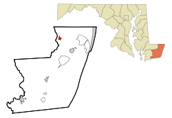
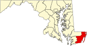
West Ocean City is a census-designated place (CDP) in Worcester County, Maryland, United States. The population was 4,375 at the 2010 census. It is part of the Salisbury, Maryland-Delaware Metropolitan Statistical Area.

<span class="mw-page-title-main">Matchwood Township, Michigan</span> Civil township in Michigan, United States

Matchwood Township is a civil township of Ontonagon County in the U.S. state of Michigan. The population was 90 at the 2020 census.

<span class="mw-page-title-main">Hayward, Missouri</span> Census-designated place in Missouri, United States

Hayward is a census-designated place and former village in Pemiscot County, Missouri, United States. The population was 131 at the 2010 census.

<span class="mw-page-title-main">Greenport West, New York</span> Census-designated place in New York, United States

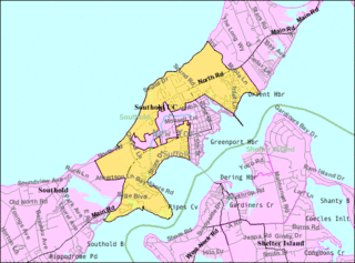
Greenport West is a census-designated place (CDP) in Suffolk County, New York, United States. The population was 2,124 at the 2010 census.

<span class="mw-page-title-main">Woodward, Pennsylvania</span> Census-designated place in Pennsylvania, United States

Woodward is an unincorporated community and census-designated place in Centre County, Pennsylvania, United States. It is part of the State College, Pennsylvania, Metropolitan Statistical Area. The population was 110 at the 2010 census.

<span class="mw-page-title-main">Jamison City, Pennsylvania</span> Census-designated place in Pennsylvania, United States

Jamison City is a census-designated place in Sugarloaf Township, Columbia County, Pennsylvania, United States. It is part of Northeastern Pennsylvania. The population was 134 at the 2010 census. It is part of the Bloomsburg-Berwick micropolitan area.

Arlington Heights is a census-designated place (CDP) in Monroe County, Pennsylvania, United States. The population was 6,331 at the 2020 census. One notable location in Arlington Heights is the Stroud Mall.

<span class="mw-page-title-main">Friedensburg, Pennsylvania</span> CDP in Pennsylvania, United States

Friedensburg is a census-designated place (CDP) in Schuylkill County, Pennsylvania, United States. The population was 828 at the time of the 2000 census.

Duncott is a census-designated place (CDP) in Schuylkill County, Pennsylvania, United States, near Minersville in the Coal Region. The population was 76 at the 2000 census. It is located in Cass Township.

<span class="mw-page-title-main">Suffield Depot, Connecticut</span> Census-designated place in Connecticut, United States

Suffield Depot is the name of a census-designated place (CDP) corresponding to the village of Suffield, the primary settlement of the town of Suffield, Connecticut, in Hartford County. The population of the CDP was 1,325 as of the 2010 census.

<span class="mw-page-title-main">Woodstock (CDP), New York</span> CDP in New York, United States

Woodstock is a hamlet in Ulster County, New York, United States. The population was 2,088 according to the 2010 census. The community of Woodstock is in the eastern part of the Town of Woodstock and is northwest of Kingston. It is located along NY 212 near its junction with NY 375. Although the name of the community and the town lent its name to the Woodstock Festival, that event did not take place in Woodstock.

<span class="mw-page-title-main">Clearbrook, New Jersey</span> Populated place in Middlesex County, New Jersey, US

Clearbrook is a gated community and census-designated place (CDP) located in Monroe Township, Middlesex County, in the U.S. state of New Jersey. It is in the western part of the township, bordered to the north by Encore at Monroe and to the east by Concordia and The Ponds. It is 3.5 miles (5.6 km) southwest of Jamesburg and 5 miles (8 km) northeast of Hightstown.

References

  1. "2020 U.S. Gazetteer Files". United States Census Bureau. Retrieved April 26, 2022.
  2. "US Gazetteer files: 2010, 2000, and 1990". United States Census Bureau. February 12, 2011. Retrieved April 23, 2011.
  3. "Census of Population and Housing". Census.gov. Retrieved June 4, 2016.
  4. "U.S. Census website". United States Census Bureau . Retrieved January 31, 2008.