Ross County | |
---|---|
Coordinates: 39°20′N83°04′W / 39.33°N 83.06°W | |
Country | United States |
State | Ohio |
Founded | August 20, 1798 [1] |
Named for | James Ross |
Seat | Chillicothe |
Largest city | Chillicothe |
Area | |
• Total | 693.03 sq mi (1,794.9 km2) |
• Land | 689.19 sq mi (1,785.0 km2) |
• Water | 3.84 sq mi (9.9 km2) 0.6% |
Population (2020) | |
• Total | 77,093 |
• Density | 110/sq mi (40/km2) |
Time zone | UTC−5 (Eastern) |
• Summer (DST) | UTC−4 (EDT) |
Congressional district | 2nd |
Website | www |
Ross County is a county in the Appalachian region of the U.S. state of Ohio. As of the 2020 United States Census, the population was 77,093. [2] Its county seat is Chillicothe, [3] the first and third capital of Ohio. Established on August 20, 1798, the county is named for Federalist Senator James Ross of Pennsylvania. [4] Ross County comprises the Chillicothe, OH Micropolitan Statistical Area, which is also included in the Columbus-Marion-Zanesville, OH Combined Statistical Area.
Ross County was described by Ephraim George Squier and Edwin Hamilton Davis as having almost "one hundred enclosures of various sizes, and five hundred mounds" in their book, Ancient Monuments of the Mississippi Valley (1848). They described the Indian-built earthworks as ranging from five to 30 feet in size, and enclosures of one to 50 acres large. These included Serpent Mound, Fort Ancient, Mound City, and Seip Earthworks (both now part of Hopewell Culture National Historical Park), and Newark Earthworks. [5]
The Scioto River flows southward through the east-central part of the county. Paint Creek drains the lower central part of the county, flowing eastward to its terminus with the Scioto at a point southeast of Chillicothe. The county terrain consists of frequent wooded hills, with the intermediate level areas devoted to agriculture. [6] The county's highest point is Farrell Hill, six miles (9.7 km) northeast of Bainbridge. [7] The county has a total area of 693 square miles (1,790 km2), of which 689 square miles (1,780 km2) is land and 3.8 square miles (9.8 km2) (0.6%) is water. [8] Ross County is the second-largest county by land area in Ohio, after Ashtabula County, as well as the fifth-largest by total area.
Census | Pop. | Note | %± |
---|---|---|---|
1800 | 8,540 | — | |
1810 | 15,514 | 81.7% | |
1820 | 20,619 | 32.9% | |
1830 | 24,068 | 16.7% | |
1840 | 27,460 | 14.1% | |
1850 | 32,074 | 16.8% | |
1860 | 35,071 | 9.3% | |
1870 | 37,097 | 5.8% | |
1880 | 40,307 | 8.7% | |
1890 | 39,454 | −2.1% | |
1900 | 40,940 | 3.8% | |
1910 | 40,069 | −2.1% | |
1920 | 41,556 | 3.7% | |
1930 | 45,181 | 8.7% | |
1940 | 52,147 | 15.4% | |
1950 | 54,424 | 4.4% | |
1960 | 61,215 | 12.5% | |
1970 | 61,211 | 0.0% | |
1980 | 65,004 | 6.2% | |
1990 | 69,330 | 6.7% | |
2000 | 73,345 | 5.8% | |
2010 | 78,064 | 6.4% | |
2020 | 77,093 | −1.2% | |
US Decennial Census [11] 1790-1960 [12] 1900-1990 [13] 1990-2000 [14] 2020 [2] |
As of the 2000 United States Census, [15] there were 73,345 people, 27,136 households, and 19,185 families in the county. The population density was 106 people per square mile (41 people/km2). There were 29,461 housing units at an average density of 42.7 units per square mile (16.5/km2). The racial makeup of the county was 91.74% White, 6.20% Black or African American, 0.31% Native American, 0.35% Asian, 0.02% Pacific Islander, 0.19% from other races, and 1.20% from two or more races. 0.58% of the population were Hispanic or Latino of any race.
There were 27,136 households, out of which 32.70% had children under the age of 18 living with them, 55.20% were married couples living together, 11.10% had a female householder with no husband present, and 29.30% were non-families. 24.90% of all households were made up of individuals, and 10.30% had someone living alone who was 65 years of age or older. The average household size was 2.50 and the average family size was 2.97.
The county population contained 24.00% under the age of 18, 8.60% from 18 to 24, 31.60% from 25 to 44, 23.60% from 45 to 64, and 12.20% who were 65 years of age or older. The median age was 37 years. For every 100 females there were 108.30 males. For every 100 females age 18 and over, there were 109.00 males.
The median income for a household in the county was $37,117, and the median income for a family was $43,241. Males had a median income of $35,892 versus $23,399 for females. The per capita income for the county was $17,569. About 9.10% of families and 12.00% of the population were below the poverty line, including 15.10% of those under age 18 and 10.20% of those age 65 or over.
As of the 2010 United States Census, there were 78,064 people, 28,919 households, and 19,782 families in the county. [16] The population density was 113 people per square mile (44 people/km2). There were 32,148 housing units at an average density of 46.6 units per square mile (18.0/km2). [17] The racial makeup of the county was 90.7% white, 6.2% black or African American, 0.4% Asian, 0.3% American Indian, 0.3% from other races, and 2.1% from two or more races. Those of Hispanic or Latino origin made up 1.0% of the population. [17] In terms of ancestry, 27.0% were German, 15.2% were Irish, 12.5% were American, and 10.5% were English. [18]
Of the 28,919 households, 32.8% had children under the age of 18 living with them, 50.2% were married couples living together, 12.6% had a female householder with no husband present, 31.6% were non-families, and 26.2% of all households were made up of individuals. The average household size was 2.48 and the average family size was 2.95. The median age was 39.8 years. [17]
The median income for a household in the county was $42,626 and the median income for a family was $50,081. Males had a median income of $42,721 versus $32,374 for females. The per capita income for the county was $20,595. About 13.1% of families and 17.3% of the population were below the poverty line, including 24.7% of those under age 18 and 8.2% of those age 65 or over. [19]
County officials are (as of June 2019):
Ross is a generally Republican county in Presidential and Congressional elections, although until recent years, Democratic candidates performed fairly well in the county. The last Democrat to win a majority in the county was Lyndon Johnson in 1964, while Bill Clinton won a plurality in 1996 and Barack Obama came within just 439 votes in 2012.
Ross is part of Ohio's 2nd congressional district, which is held by Republican Brad Wenstrup.
Year | Republican | Democratic | Third party | |||
---|---|---|---|---|---|---|
No. | % | No. | % | No. | % | |
2020 | 22,278 | 66.77% | 10,557 | 31.64% | 530 | 1.59% |
2016 | 18,652 | 61.02% | 10,356 | 33.88% | 1,557 | 5.09% |
2012 | 15,008 | 49.76% | 14,569 | 48.31% | 583 | 1.93% |
2008 | 16,759 | 52.49% | 14,455 | 45.28% | 711 | 2.23% |
2004 | 17,231 | 54.41% | 13,978 | 44.14% | 462 | 1.46% |
2000 | 13,706 | 52.68% | 11,662 | 44.83% | 648 | 2.49% |
1996 | 10,286 | 39.87% | 12,649 | 49.03% | 2,862 | 11.09% |
1992 | 10,825 | 39.84% | 10,452 | 38.46% | 5,896 | 21.70% |
1988 | 14,563 | 60.39% | 9,271 | 38.45% | 279 | 1.16% |
1984 | 17,015 | 66.60% | 8,020 | 31.39% | 513 | 2.01% |
1980 | 13,251 | 55.54% | 9,355 | 39.21% | 1,253 | 5.25% |
1976 | 11,477 | 50.45% | 10,743 | 47.22% | 531 | 2.33% |
1972 | 15,573 | 71.15% | 5,879 | 26.86% | 436 | 1.99% |
1968 | 11,284 | 50.72% | 6,873 | 30.90% | 4,089 | 18.38% |
1964 | 9,623 | 43.10% | 12,704 | 56.90% | 0 | 0.00% |
1960 | 14,075 | 60.90% | 9,036 | 39.10% | 0 | 0.00% |
1956 | 13,036 | 63.73% | 7,418 | 36.27% | 0 | 0.00% |
1952 | 13,431 | 61.01% | 8,585 | 38.99% | 0 | 0.00% |
1948 | 10,398 | 52.08% | 9,524 | 47.71% | 42 | 0.21% |
1944 | 11,424 | 53.50% | 9,928 | 46.50% | 0 | 0.00% |
1940 | 11,780 | 48.62% | 12,447 | 51.38% | 0 | 0.00% |
1936 | 9,817 | 43.75% | 12,503 | 55.71% | 121 | 0.54% |
1932 | 9,575 | 47.34% | 10,542 | 52.12% | 110 | 0.54% |
1928 | 11,179 | 64.59% | 6,062 | 35.02% | 67 | 0.39% |
1924 | 8,431 | 53.86% | 6,028 | 38.51% | 1,194 | 7.63% |
1920 | 9,330 | 56.46% | 7,063 | 42.74% | 133 | 0.80% |
1916 | 4,857 | 47.76% | 5,154 | 50.68% | 159 | 1.56% |
1912 | 3,600 | 36.76% | 4,494 | 45.89% | 1,698 | 17.34% |
1908 | 5,432 | 49.69% | 5,325 | 48.71% | 174 | 1.59% |
1904 | 5,472 | 54.60% | 4,387 | 43.77% | 163 | 1.63% |
1900 | 5,463 | 51.61% | 5,035 | 47.56% | 88 | 0.83% |
1896 | 5,562 | 52.32% | 4,967 | 46.73% | 101 | 0.95% |
1892 | 4,632 | 49.19% | 4,489 | 47.67% | 296 | 3.14% |
1888 | 4,942 | 50.70% | 4,584 | 47.03% | 221 | 2.27% |
1884 | 4,830 | 50.30% | 4,723 | 49.18% | 50 | 0.52% |
1880 | 4,734 | 50.81% | 4,551 | 48.85% | 32 | 0.34% |
1876 | 4,177 | 48.41% | 4,431 | 51.35% | 21 | 0.24% |
1872 | 3,650 | 49.55% | 3,711 | 50.38% | 5 | 0.07% |
1868 | 3,230 | 46.98% | 3,645 | 53.02% | 0 | 0.00% |
1864 | 3,380 | 51.34% | 3,204 | 48.66% | 0 | 0.00% |
1860 | 3,043 | 47.35% | 2,806 | 43.67% | 577 | 8.98% |
1856 | 2,436 | 42.69% | 2,681 | 46.99% | 589 | 10.32% |
Pickaway-Ross lies in the Northern part of the county. Students from the following affiliated Ross and Pickaway county districts attend the vocational school:
Ohio University established a regional campus in Chillicothe in 1966. The university has over 2,500 students enrolled as of 2010, ranging from traditional-aged students and non-traditional learners. [21]
Scioto County is a county along the Ohio River in the south-central part of the U.S. state of Ohio. At the 2020 census, the population was 74,008. Its county seat is Portsmouth. The county was founded on March 24, 1804, from Adams County and is named for a Native American word referring to deer or deer-hunting. Scioto County comprises the Portsmouth, OH Micropolitan Statistical Area. It is at the confluence of the Scioto and Ohio rivers.
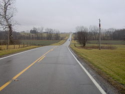
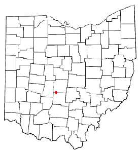
Pickaway County is a county in the U.S. state of Ohio. As of the 2020 census, the population was 58,539. Its county seat is Circleville. Its name derives from the Pekowi band of Shawnee Indians, who inhabited the area.
Jefferson County is a county located in the U.S. state of Ohio. As of the 2020 census, the population was 65,249. Its county seat is Steubenville. The county is named for Thomas Jefferson, who was vice president at the time of its creation.
Hocking County is a county located in the U.S. state of Ohio. As of the 2020 census, the population was 28,050. Its county seat is Logan. The county was organized on March 1, 1818, from land given by Athens, Fairfield, and Ross counties. Its name is from the Hocking River, the origins of which are disputed but is said to be a Delaware Indian word meaning "bottle river". Hocking County is included in the Columbus, OH Metropolitan Statistical Area.
Franklin County is a county in the U.S. state of Ohio. As of the 2020 census, the population was 1,323,807, making it the most populous county in Ohio. Most of its land area is taken up by its county seat, Columbus, the state capital and most populous city in Ohio. The county was established on April 30, 1803, less than two months after Ohio became a state, and was named after Benjamin Franklin. Originally, Franklin County extended north to Lake Erie before it was subdivided into smaller counties. Franklin County is the central county of the Columbus, Ohio Metropolitan Statistical Area.
Fayette County is a county located in the U.S. state of Ohio. As of the 2020 census, the population was 28,951. Its county seat and largest city is Washington Court House. The county was named for the Marquis de Lafayette, a Frenchman who was an officer in the American Army in the Revolution, when established on March 1, 1810.
Fairfield County is a county located in the U.S. state of Ohio. As of the 2020 census, the population was 158,921. Its county seat and largest city is Lancaster. Its name is a reference to the Fairfield area of the original Lancaster.
Enon is a village in Clark County, Ohio, United States. The population was 2,455 at the 2020 census. It is part of the Springfield, Ohio Metropolitan Statistical Area.
Ostrander is a village in Delaware County, Ohio, United States. The population was 1,094 at the 2020 census.
Ashville is a village in Pickaway County, Ohio, United States. The population was 4,621 at the 2020 census. Ashville is located 17 miles south of Columbus and 8 miles north of Circleville.
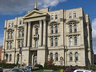
Circleville is a city in and the county seat of Pickaway County, Ohio, United States. The city is situated along the Scioto River, 25 miles (40 km) south of Columbus. The population was recorded to be 13,927 in the 2020 census.
Commercial Point is a village in Pickaway County, Ohio, United States. The population was 3,078 at the 2020 census. It is the fastest-growing affluent community in Pickaway County and one of the fastest-growing villages in central Ohio. It is a suburb of Columbus, OH
Orient is a census-designated place and former village in Pickaway County, Ohio, United States. The population was 246 at the 2020 census.
Waverly is a city in, and the county seat of, Pike County, Ohio, United States, located about 14 miles (23 km) south of Chillicothe. The population was 4,165 at the 2020 census. The town was formed in 1829, as the construction of the Ohio and Erie Canal along the west bank of the Scioto River brought new growth to the area. In 1861, the county seat was moved here from Piketon.
Bainbridge is a village in Ross County, Ohio, United States, along Paint Creek. The population was 765 at the 2020 census.
Chillicothe is a city in and the county seat of Ross County, Ohio, United States. Located along the Scioto River 45 miles (72 km) south of Columbus, Chillicothe was the first and third capital of Ohio. It is the only city in Ross County and is the center of the Chillicothe micropolitan area. The population was 22,059 at the 2020 census. Chillicothe is a designated Tree City USA by the National Arbor Day Foundation.
Frankfort is a village in Ross County, Ohio, United States, along the North Fork of Paint Creek. The village is located in Concord Township. The population was 1,084 at the 2020 census.
Kingston is a village in Ross County, Ohio, United States. The population was 1,262 at the 2020 census.
Franklin Furnace is a census-designated place (CDP) in Scioto County, Ohio, United States, along the Ohio River. The population was 1,525 at the 2020 census.
Adena is a village in southwestern Jefferson and southeastern Harrison counties in the U.S. state of Ohio. The population was 664 at the 2020 census. It is part of the Weirton–Steubenville metropolitan area.