Bath and North East Somerset (B&NES) is a unitary authority district in Somerset, South West England. Bath and North East Somerset Council was created on 1 April 1996 following the abolition of the county of Avon. It is part of the ceremonial county of Somerset.

Chilcompton is a village and civil parish in Somerset, England, situated in the Mendip Hills two miles south of Midsomer Norton and 3.0 miles south-west of Westfield. It is situated on the B3139 road between Radstock and Wells, close to the A37.

Richard de Beaufré comte de Guyon was a British-born Hungarian soldier, general in the Hungarian revolutionary army and Ottoman pasha.

Bathwick is an area and electoral ward in the city of Bath, in the Bath and North East Somerset district, in the ceremonial county of Somerset, England, on the opposite bank of the River Avon to the historic city centre.
Batheaston is a village and civil parish 2 miles (3.2 km) east of the English city of Bath, on the north bank of the River Avon. The parish had a population of 2,735 in 2011. The northern area of the parish, on the road to St Catherine, is an area known as Northend.
John Palmer was an English architect who worked on some of the notable buildings in the city of Bath, Somerset, UK. He succeeded Thomas Baldwin as City Architect in 1792. He died in Bath.
St Michael's Church is a Church of England parish church in Bath, Somerset.

The Paragon in the Walcot area of Bath, Somerset, England is a street of Georgian houses which have been designated as listed buildings. It was designed by Thomas Warr Attwood. It now forms part of the A4.

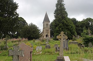
Locksbrook Cemetery is a municipal cemetery located in Lower Weston, Bath, England. It was opened in 1864 as Walcot Cemetery, and occupies 12 acres (4.9 ha), originally serving the parishes of Walcot, Weston and St Saviour's. The cemetery was closed for general use in 1937 with over 30,000 interments there, though additional burials in existing graves continue. The majority of the cemetery was for about 29,500 burials from Walcot parish, with the north of the cemetery for Weston and St Saviour parishes.
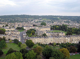
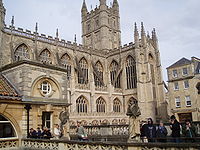
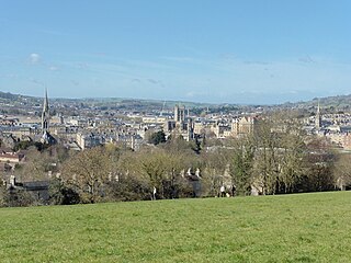
The buildings and architecture of Bath, a city in Somerset in the south west of England, reveal significant examples of the architecture of England, from the Roman Baths, to the present day. The city became a World Heritage Site in 1987, largely because of its architectural history and the way in which the city landscape draws together public and private buildings and spaces. The many examples of Palladian architecture are purposefully integrated with the urban spaces to provide "picturesque aestheticism". In 2021, the city was added to a second World Heritage Site, a group of historic spa towns across Europe known as the "Great Spas of Europe". Bath is the only entire city in Britain to achieve World Heritage status, and is a popular tourist destination.
The Anglican Bath Abbey Cemetery, officially dedicated as the Cemetery of St Peter and St Paul, was laid out by noted cemetery designer and landscape architect John Claudius Loudon (1783–1843) between 1843 and 1844 on a picturesque hillside site overlooking Bath, Somerset, England.

Kingsmead is an electoral ward within Bath, England, which encompasses most of Bath city centre and stretches west along the A4 to meet Newbridge and Weston wards. The ward elects two councillors to the Bath and North East Somerset unitary authority.
Abbey was an electoral ward covering the centre of Bath, England. It was abolished as part of the boundary changes effected at the elections held on 2 May 2019.

Westfield is a village and civil parish in Bath and North East Somerset in the ceremonial county of Somerset, England. The village lies on the Fosse Way between the towns of Radstock and Midsomer Norton.

Elections were held on 6 May 1999 to elect 65 local councillors for Bath and North East Somerset Council, the second election for the council. The results are show below. After the election, a minority Liberal Democrat administration was formed.

Elections were held on 1 May 2003 to elect 65 local councillors for Bath and North East Somerset Council. The results are shown below. Following the election, a coalition was formed between the Liberal Democrats and Conservative councillors. Cllr Paul Crossley became leader of the council.

Elections were held on 3 May 2007 to elect 65 local councillors for Bath and North East Somerset Council. The results are show below. Following the elections, a Conservative minority administration was formed. Cllr Francine Haeberling became leader of the council. This replaced the previous Liberal Democrat and Conservative coalition.

The following is a timeline of the history of the city of Bath, Somerset, England.

The 2015 Bath and North East Somerset Council election took place on 7 May 2015 to elect members of Bath and North East Somerset Council in England. This coincided with other local elections and the 2015 general election.
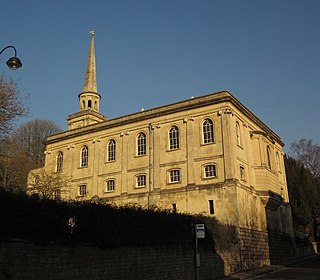
The Anglican Church of St Swithin on The Paragon in the Walcot area of Bath, England, was built between 1777 and 1790. It is a Grade II* listed building.