Weston, Bath

Last updated

Weston
High St, Weston, Bath.jpg
Southern High Street, Weston, 2010
Somerset UK location map.svg
Red pog.svg
Weston
Location within Somerset
Population5,237 (ward, 2011) [1]
OS grid reference ST728665
Unitary authority
Ceremonial county
Region
Country England
Sovereign state United Kingdom
Post town BATH
Postcode district BA1
Dialling code 01225
Police Avon and Somerset
Fire Avon
Ambulance South Western
UK Parliament
List of places
UK
England
Somerset
51°23′49″N2°23′35″W / 51.397°N 2.393°W / 51.397; -2.393

Weston is a suburb and electoral ward of Bath in Bath and North East Somerset, Somerset, England, located in the northwest of the city. [2] Originally a separate village, Weston has become part of Bath as the city has grown, first through the development of Lower Weston in Victorian times and then by the incorporation of the village into the city, with the siting of much local authority housing there in the period after World War II.

Contents

The ward includes Upper Weston, Weston village, Weston Park and the lower slopes of Primrose Hill. The area known as Lower Weston, south of Weston Road, is within Newbridge ward. [3]

History

The earliest evidence of occupation comes from two Celtic caddy spoons found in the village in 1825. There are believed to have been used as ceremonial anointing regalia. [4]

During the 10th century, Weston had been divided into two estates. One, on the slopes of Lansdown was given by Edmund I to Aethelare in 946. [5] Weston was the birthplace of Saint Alphege who was born around 954. [6] Two manors with 41 households are recorded in the Domesday Book of 1086: one held by Bath Abbey and the other by Arnulf de Hesding. [7]

During the 12th and 13th centuries Weston had close ties with the monks of the abbey, and in the late 13th century the first vicar of Weston was appointed by the church. [8] Weston was part of the hundred of Bath Forum, [9] [10] with a manorial court or halmote being held in the parish. [11] The land continued to be owned by the church and leased to tenants until the dissolution of the monasteries in 1539, [12] after which the estates in Weston reverted to the king. In 1628 the land was sold to the Corporation of London although the king continued to receive rent until 1671, when it was sold to Sir Walter Long, [13] Member of Parliament for Bath from 1679 (the Habeas Corpus Parliament) to 1681. Following the Battle of Lansdowne in 1643, some of the defeated Roundheads took refuge in Weston. [14]

The village expanded during the 19th century with many areas being drained, the church rebuilt and new schools established. The Georgian expansion of Bath saw many houses built in Weston, and in 1834 Partis College was built nearby in Newbridge. Developments continued into the Victorian era with Weston Park and Combe Park being developed. [15]

Weston was an ancient parish extending from the River Avon to the Gloucestershire boundary north of Lansdown. It became a civil parish in 1866. The southern parts of the parish were absorbed into Bath in 1911 and 1951, and the remaining, more rural, parts were absorbed into the civil parishes of Charlcombe and Kelston on 1 April 1953. [16] In 1951 the parish had a population of 175. [17]

Parts of Weston are at risk of flooding due to old watercourses, sinks and springs in the area. West Brook now runs underground below the High Street, but floods periodically. In 2013 the Weston Catchment alleviation scheme was announced to further protect the area. [18]

Services

Bath's main hospital, the Royal United Hospital, is just over the ward boundary in Newbridge, on one of the roads from central Bath into Weston.

Weston has two primary schools: Weston All Saints C.E. V.C Primary School, [19] and St Mary's Catholic Primary School. [20] Lower Weston is served by Newbridge School; an earlier primary school called Weston St John's closed when the primary departments at Newbridge expanded in the 1970s.

Weston has many local amenities, including a recreation ground [21] and youth club, and shops and services including a bakery, Spar off-licence, post office, pharmacy, a takeaway, a bike shop and a newsagents. There is also a carpet shop and two hair salons. The village is dominated by a Tesco Express supermarket.

Weston village is home to the 66th Bath Scout Group who meet at the former school on the High Street. [22] In Lower Weston, the 69th Bath Scout Group meet at the Methodist church. [23] Bath Scouts also own a campsite on the edge of Weston at Cleeve Hill. Rainbows, Brownies and Guides also meet within the village, along with a Boys' Brigade Company.

Religious sites

The Countess of Huntingdon's Chapel, an early Methodist chapel built by the Countess of Huntingdon, has now been converted into housing Countess of Huntingdon's Chapel, Weston, Bath.jpg
The Countess of Huntingdon's Chapel, an early Methodist chapel built by the Countess of Huntingdon, has now been converted into housing

The village parish church is All Saints, founded no later than 1156. The current church dates from 1832 and was designed by the local architect John Pinch the younger, except for the tower which dates from the 15th century. [26] The Lower Weston parish church is St John's, barely a mile from Bath's city centre, and now in Kingsmead ward. There is also a Moravian church sited at the bottom of Lansdown Lane; the nearest Catholic church is St. Mary's on Julian Road.

Transport

Weston is served by three main bus routes providing connections towards Lower Weston, Newbridge, Bath City Centre, Combe Down, and Odd Down.

Service 14 operates up to every 9 minutes on weekdays; up to every 12 minutes on Saturdays; and up to every 20 minutes on Sundays on the following route:

14: Eastfield Avenue → Lansdown Lane → High Street, Weston → Royal United Hospital → Combe Park → Chelsea Road → Upper Bristol Road for Royal Victoria Park and interchange with other services → City Centre James Street West → City Centre Bus Station for interchange with bus and rail services → Wells Road → Bear Flat → Bloomfield Road → Frome Road → Odd Down Noads Corner

Service 9 operates between Upper Weston and City Centre Bus Station via High Street, Weston, Penn Hill Road, Newbridge Hill, Upper Bristol Road, and Bath City Centre.

Services 20A/C are city circular services and provide connections to many parts of Bath.

The Weston (Bath) railway station was at Lower Weston and closed in 1953, although the platform building and the stationmaster's house still exist. The station was on the Midland Railway line from Bath to Bristol and to the north, which itself closed in 1966. [27]

Upper Weston, from Penn Hill Weston, Bath from Penn Hill.jpg
Upper Weston, from Penn Hill

Related Research Articles

<span class="mw-page-title-main">Bath, Somerset</span> City in Somerset, England

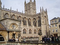
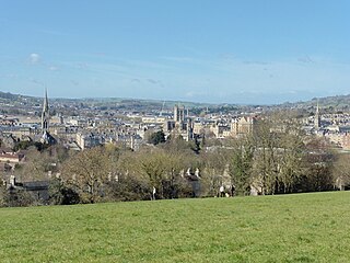
Bath is a city in the ceremonial county of Somerset, England, known for and named after its Roman-built baths. At the 2021 Census, the population was 94,092. Bath is in the valley of the River Avon, 97 miles (156 km) west of London and 11 miles (18 km) southeast of Bristol. The city became a UNESCO World Heritage Site in 1987, and was later added to the transnational World Heritage Site known as the "Great Spa Towns of Europe" in 2021. Bath is also the largest city and settlement in Somerset.

<span class="mw-page-title-main">Bath and North East Somerset</span> District in England

Bath and North East Somerset (B&NES) is a unitary authority district in Somerset, South West England. Bath and North East Somerset Council was created on 1 April 1996 following the abolition of the county of Avon. It is part of the ceremonial county of Somerset.

<span class="mw-page-title-main">North Somerset</span> District in England

North Somerset is a unitary authority in the ceremonial county of Somerset, England. The council is based in Weston-super-Mare, the area's largest town. The district also contains the towns of Clevedon, Nailsea and Portishead, along with a number of villages and surrounding rural areas. Some southern parts of the district fall within the Mendip Hills, a designated Area of Outstanding Natural Beauty.

<span class="mw-page-title-main">Backwell</span> Village in Somerset, England

Backwell is a village and civil parish in the unitary authority of North Somerset and in 2011 had a population of 4,589. The village lies about 7 miles (11 km) southwest of Bristol, south of the A370 to Weston-super-Mare. The parish includes the hamlets of Backwell Common, Backwell Green, and Backwell Farleigh, and the districts of Backwell West Town and Downside.

<span class="mw-page-title-main">Long Ashton</span> Human settlement in England

Long Ashton is a village and civil parish in Somerset, England. It falls within the unitary authority of North Somerset and is one of a number of large villages just outside the boundary of city of Bristol urban area. The parish has a population of 6,044. The parish includes the hamlet of Yanley, and the residential area of Leigh Woods.

<span class="mw-page-title-main">Combe Down</span> Village on the outskirts of Bath, United Kingdom

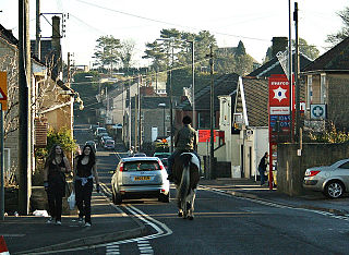
Combe Down is a village on the outskirts of Bath, England, in the Bath and North East Somerset unitary authority area, within the ceremonial county of Somerset.

<span class="mw-page-title-main">Monkton Combe</span> Human settlement in England

Monkton Combe is a village and civil parish in north Somerset, England, 3 miles (4.8 km) south of Bath. The parish, which includes the hamlet of Tucking Mill, had a population of 554 in 2013. It was formerly known as Combe, owing to its geography, while it was also known as Monckton Combe and Combe Monckton until last century.

<span class="mw-page-title-main">Peasedown St John</span> Human settlement in England

Peasedown St John is a village and civil parish in Somerset, England, standing on a hilltop roughly 5 miles (8 km) south-southwest of the city of Bath, and 2 miles (3 km) north-east of the town of Radstock at the foot of the Mendip Hills. Peasedown used to be a coal mining village, and after the last of the mines shut in the 1970s it became a dormitory village for Bath, Trowbridge and to a lesser extent Bristol. Its size was increased by substantial housing developments in the 1960s, 1970s and late 1990s, making it one of the largest villages in Somerset.

<span class="mw-page-title-main">Lansdown, Bath</span> Suburb of Bath, England

Lansdown is a suburb of the World Heritage City of Bath, England, that extends northwards from the city centre up a road of the same name. Among its most distinctive architectural features are Lansdown Crescent and Sion Hill Place, which includes a campus of Bath Spa University.

<span class="mw-page-title-main">Churchill, Somerset</span> Village and civil parish in Somerset, England

Churchill is a village and civil parish in the unitary authority of North Somerset, part of the ceremonial county of Somerset. It is located on the western edge of the Mendip Hills, about 8 miles (12.9 km) east of Weston-super-Mare, and about 15 miles (24.1 km) south-west of Bristol. The parish, which includes the village of Lower Langford and the hamlet of Upper Langford, has a population of 2,250.

<span class="mw-page-title-main">High Littleton</span> Village in Somerset, England

High Littleton is a village and civil parish in Somerset, England, about 1.2 miles (1.9 km) north of Paulton and 7.5 miles (12 km) south-west of Bath. The parish includes the small village of Hallatrow and the hamlets of White Cross, Greyfield and Mearns; the northeastern part of High Littleton village is known as Rotcombe.

<span class="mw-page-title-main">Worle</span> Human settlement in England

Worle is a village in the civil parish of Weston-Super-Mare, in the North Somerset district, in the ceremonial county of Somerset, England. It is joined to the seaside town of Weston-super-Mare on its western edge. It, however, maintains a very separate identity, and may now be bigger than its more famous neighbour. Worle pre-dates Weston and was mentioned in the Domesday Book of 1086. In the book, it is said that Worle was owned by Walter of Douai, and consisted of 750 acres (3.0 km2) and valued at 6.5 hides. "Walter of Douai holds of the King, Worle. Edgar held it in the time of King Edward, and gelded for six hides and a half." The parish church of St Martin's sits on the side of Worlebury Hill and overlooks the village.

<span class="mw-page-title-main">Royal United Hospital</span> Hospital in Somerset, England

The Royal United Hospital (RUH) is a major acute-care hospital in the Weston suburb of Bath, England, which lies approximately 1.5 miles (2.4 km) west of the city centre. The hospital has 565 beds and occupies a 52 acres (21 ha) site. It is the area's major accident and emergency hospital, with a helicopter landing point on the adjacent Lansdown Cricket Club field. The hospital is operated by the Royal United Hospitals Bath NHS Foundation Trust.

<span class="mw-page-title-main">Newbridge, Bath</span> Electoral ward in Bath, United Kingdom

Newbridge is a largely residential electoral ward on the western edge of Bath, Somerset, England.

<span class="mw-page-title-main">Farmborough</span> Human settlement in England

Farmborough is a small village and civil parish, 6 miles (9.7 km) south west of Bath in Somerset, England. It straddles both the A39 and A368 roads. The parish has a population of 1,035.

<span class="mw-page-title-main">Charlcombe</span> Human settlement in England

Charlcombe is a civil parish and small village just north of Bath in the Bath and North East Somerset unitary authority, Somerset, England. The parish had a population of 422 in 2011, and includes the villages of Woolley and Langridge and the hamlet of Lansdown.

<span class="mw-page-title-main">Sparkford</span> Village in Somerset, England

Sparkford is a village and civil parish in Somerset, England. The parish includes the village of Weston Bampfylde.

<span class="mw-page-title-main">Kingsmead, Bath</span> Electoral ward in Bath, United Kingdom

Kingsmead is an electoral ward within Bath, England, which encompasses most of Bath city centre and stretches west along the A4 to meet Newbridge and Weston wards. The ward elects two councillors to the Bath and North East Somerset unitary authority.

<span class="mw-page-title-main">2015 Bath and North East Somerset Council election</span>

The 2015 Bath and North East Somerset Council election took place on 7 May 2015 to elect members of Bath and North East Somerset Council in England. This coincided with other local elections and the 2015 general election.

References

  1. "Weston". UKCrimeStats.com. Retrieved 12 January 2012.
  2. "Ward Maps". Bath & North East Somerset Council. Archived from the original on 3 April 2011. Retrieved 10 March 2011.
  3. "Election Maps". Ordnance Survey. Retrieved 17 October 2020.
  4. Hargood-Ash page 6
  5. Hargood-Ash pages 9-12
  6. Knowles pages 28, 241
  7. Weston in the Domesday Book
  8. Hargood-Ash pages 19-28
  9. Collinson page 97
  10. "Somerset Hundreds". GENUKI. Retrieved 9 September 2011.
  11. Hargood-Ash page 29
  12. Hargood-Ash page 39
  13. Hargood-Ash page 53
  14. Hargood-Ash page 84
  15. Hargood-Ash pages 100-110
  16. Great Britain Historical GIS / University of Portsmouth, Weston CP/AP . Retrieved 17 March 2020.
  17. "Population statistics Weston AP/CP through time". A Vision of Britain through Time . Retrieved 30 March 2024.
  18. "2m flood relief project go-ahead in Bath". Bath Chronicle. 8 February 2013. Retrieved 10 February 2013.
  19. "Weston All Saints C.E. V.C Primary School". BANES. Retrieved 5 July 2008.
  20. "St Marys Catholic Primary School". BANES. Retrieved 5 July 2008.
  21. "Weston Recreation Ground, registered charity no. 304672". Charity Commission for England and Wales.
  22. "66th Bath (Weston Village) Scout Group" . Retrieved 12 September 2019.
  23. "69th Bath (Lower Weston) Scout Group" . Retrieved 12 September 2019.
  24. Historic England. "Countess of Huntingdon's Chapel (Grade II) (1395382)". National Heritage List for England .
  25. Memorial Plaques at Lady Huntingdon's Chapel, Trafalgar Road, Weston, Bath (PDF) (Report). Bath Record Office. 2016. Retrieved 14 July 2017.
  26. "All Saints Weston". Images of England. English Heritage. Archived from the original on 11 October 2012. Retrieved 5 July 2008.
  27. Oakley

Bibliography