Wales, South Yorkshire

Last updated

Wales
Wales, St John The Baptist - geograph.org.uk - 235481.jpg
St. John the Baptist church
South Yorkshire UK location map.svg
Red pog.svg
Wales
Location within South Yorkshire
Area10.29 km2 (3.97 sq mi)
Population1,260 (2011 census) Civil parish: 7,069 [1]
  Density 122/km2 (320/sq mi)
OS grid reference SK480829
Civil parish
  • Wales
Metropolitan borough
Metropolitan county
Region
Country England
Sovereign state United Kingdom
Post town SHEFFIELD
Postcode district S26
Dialling code 01909
Police South Yorkshire
Fire South Yorkshire
Ambulance Yorkshire
UK Parliament
List of places
UK
England
Yorkshire
53°20′N1°17′W / 53.33°N 1.29°W / 53.33; -1.29

Wales is a village and a civil parish in the Metropolitan Borough of Rotherham in South Yorkshire, England. [2] Historically part of the West Riding of Yorkshire, it borders to the south Derbyshire and is astride the M1 motorway. The civil parish of Wales, which has a population of 6,455, [3] increasing to 7,069 at the 2011 Census, [1] encompasses the village and neighbouring settlement Kiveton Park. [4]

Contents

Etymology

The village shares its name with the country of Wales, and it is likely that the two placenames share a derivation (see: Etymology of Wales). As such, the village name derives from the Germanic word *Walhaz, a term used by Germanic people across Europe to refer to the Romanised inhabitants of the former Empire. It is suggested therefore, that the name records the continuation of a "British" population in this area, which survived the arrival of the Anglo-Saxons, and remained distinctively Romano-British in language and culture. An alternative explanation suggests that the settlement's name may be derived from the word Waelas, meaning "field of battle". [2]

History

The first written reference to the village is as Walesho when the Saxon thegn, Wulfric Spot is recorded as possessing it in 1002, by the time of the Doomsday Book, the village is recorded as Walise. Sir William Hewet, Lord Mayor of London in 1559, was born in Wales, and his descendants, the Dukes of Leeds, would come to dominate the area. The collieries at Waleswood and Kiveton Park historically provided employment in the area, including to migrants from Wales' namesake country, until Kiveton Park Colliery was closed in September 1994. [2]

Waleswood

Waleswood is a small hamlet located to the north-west of Wales. Historically the hamlet was known for Waleswood Hall, and later Waleswood Colliery, which also featured a railway station. Much of the former colliery site is now occupied by the Gulliver's Valley theme park. [5]

Wales Bar

Wales Bar is another hamlet, located to the west of Wales. The village contains typical 20th Century miners housing, with many of the former occupants working in the surrounding collieries at Waleswood and Brookhouse. [6]

Geography

The village of Wales itself is located at approximately 53°20′30″N1°16′45″W / 53.34167°N 1.27917°W / 53.34167; -1.27917 , at an elevation of around 300 feet (100 m) above sea level. It lies on the A618 and B6059 roads. The M1 motorway bisects the parish, while the southern boundary is partly marked by the Chesterfield Canal whose Norwood Tunnel runs under meadowland to the south. To the west of the village is Rother Valley Country Park.

Education and employment

Education in Wales is provided by Wales Primary School and Wales High School. The industrial estate at Wales Common continues to be a large source of employment (not least the food manufacturer Greencore Prepared Foods) & LuK, part of the multi-national manufacturing group producing clutch & automotive parts. [7]

See also

Related Research Articles

Anston is a civil parish in South Yorkshire, England, formally known as North and South Anston. The parish of Anston consists of the settlements of North Anston and South Anston, divided by the Anston Brook.

<span class="mw-page-title-main">Metropolitan Borough of Rotherham</span> Metropolitan borough in South Yorkshire, England

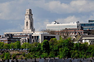
The Metropolitan Borough of Rotherham is a metropolitan borough of South Yorkshire, England. It is named after its main settlement of Rotherham. The wider borough spans a larger area and covers the outlying towns of Maltby, Swinton, Wath-upon-Dearne, Dinnington. As well as the villages of Rawmarsh and Laughton. A large valley spans the entire borough and is referred to as the "Rother Valley".

<span class="mw-page-title-main">Metropolitan Borough of Barnsley</span> Metropolitan borough in England

The Metropolitan Borough of Barnsley is a metropolitan borough in South Yorkshire, England; the main settlement is Barnsley and other notable towns include Penistone, Wombwell and Hoyland.

<span class="mw-page-title-main">Maltby, South Yorkshire</span> Town and civil parish in South Yorkshire, England

Maltby is a former mining town and civil parish in the Metropolitan Borough of Rotherham, South Yorkshire, England. It was historically in the West Riding of Yorkshire. It is located 6 miles (10 km) east of Rotherham and 10 miles (16 km) north-east of Sheffield. It forms a continuous urban area with Hellaby, separated from the rest of Rotherham by the M18 motorway. It had a population of 16,688 at the 2011 Census.

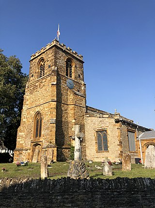
Kiveton Park is a village within the Metropolitan Borough of Rotherham, in South Yorkshire, England. Historically a part of the West Riding of Yorkshire, from the Norman conquest to 1868, Kiveton was a hamlet of the parish of Harthill-with-Woodall. It subsequently transferred to the civil parish of Wales which takes its name from the neighbouring village.

Ecclesfield is a village and civil parish in the City of Sheffield, South Yorkshire, England, about 4 miles (6 km) north of Sheffield City Centre. Ecclesfield civil parish had a population of 32,073 at the 2011 Census. Ecclesfield wards of the City of Sheffield had a population of 35,994 in 2011. The population of Ecclesfield village stood at 7,163 in the most recent census.

<span class="mw-page-title-main">Adwick le Street</span> Village in South Yorkshire, England

Adwick le Street is a village in the City of Doncaster, South Yorkshire, England. The Adwick ward of Doncaster Metropolitan Borough Council had a population of 15,911 at the 2011 Census. It is situated north-west of Doncaster. Under the 2011 census, the settlement had a population of 10,507.

<span class="mw-page-title-main">Treeton</span> Village and civil parish in South Yorkshire, England

Treeton is a village and civil parish of the Metropolitan Borough of Rotherham in South Yorkshire, England. It is located about 4 miles (6 km) south of the town of Rotherham and 5 miles (8 km) east of Sheffield City Centre.

<span class="mw-page-title-main">Killamarsh</span> Village and civil parish in Derbyshire, England

Killamarsh is a village and civil parish in North East Derbyshire, England, bordering Rotherham to the north and Sheffield to the north-west.

<span class="mw-page-title-main">Kiveton Park F.C.</span> Association football club in England

Kiveton Park Football Club is a football club based in Kiveton Park, South Yorkshire, England. They are currently members of the Sheffield & Hallamshire County Senior League Division One and play at Wales High School.

<span class="mw-page-title-main">Collingtree</span> Village in Northamptonshire, England

Collingtree is a village and civil parish in the West Northamptonshire district of Northamptonshire, England. It is part of the Northampton built-up area.

<span class="mw-page-title-main">Todwick</span> Village in South Yorkshire, England

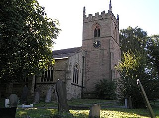
Todwick is a village in the Metropolitan Borough of Rotherham in South Yorkshire, England. It has a population of 1,637, reducing marginally to 1,634 at the 2011 Census, and contains a primary school and a nursery, Todwick Early Years. Todwick also is home to a pub, The Red Lion, and a church. There is a village hall adjacent to the primary school, and this is on the corner of Kiveton Lane and The Pastures. The Pastures has the only shops in the village on it; Cyprus Gardens pizza house and Heaven Is Homemade Vintage Tea Room.

Waleswood Colliery was a coal mine situated between Swallownest and Wales Bar, near Rotherham, South Yorkshire, England. The colliery was adjacent to the Rotherham to Clowne road and the main line of the Manchester, Sheffield and Lincolnshire Railway about 2 miles east of Woodhouse.

<span class="mw-page-title-main">Woodall, South Yorkshire</span> Hamlet in South Yorkshire, England

Woodall is a small hamlet in the civil parish of Harthill with Woodall situated in the Metropolitan Borough of Rotherham, South Yorkshire England. In the 2001 government census the parish as a whole had 1,909 inhabitants. It is home to a Welcome Break service station of the same name.

Ulley is a village and civil parish of the Metropolitan Borough of Rotherham in South Yorkshire, England. The population of the civil parish as of the 2011 census was 172. It is located about 4 miles (6 km) south of the town of Rotherham and 7 miles (11 km) east of Sheffield City Centre.

<span class="mw-page-title-main">Brookhouse Colliery</span> Former coal mine in South Yorkshire

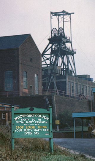
Brookhouse Colliery was a coal mine within the Metropolitan Borough of Rotherham, South Yorkshire, England. It was operational between 1929 and 1985.

Aston Colliery was a small coal mine sunk on Aston Common, within Rotherham Rural District but six miles east of Sheffield in the 1840s. In 1864 its workings were taken over and developed by the North Staveley Colliery Company, part of the Staveley Coal and Iron Company, based in North Derbyshire. It was later acquired by the Sheffield Coal Company.

<span class="mw-page-title-main">Woolley, West Yorkshire</span> Human settlement in England

Woolley is a village and civil parish in the City of Wakefield in West Yorkshire, England. It had a population of 575 in 2001, which increased to 1,339 at the 2011 Census. It is 6 miles (10 km) north of Barnsley, and 7 miles (11 km) south of Wakefield.

<span class="mw-page-title-main">Tinsley, South Yorkshire</span> Human settlement in England

Tinsley is a suburb of north-eastern Sheffield, South Yorkshire, England; it falls within the Darnall ward of the city.

<span class="mw-page-title-main">Harry Crofts Colliery</span> Former coal mine in South Yorkshire, England

Harry Crofts Colliery was a small, short lived coal mine within the parish of South Anston, near Rotherham, South Yorkshire.

References

  1. 1 2 UK Census (2011). "Local Area Report – Wales Parish (E04000122)". Nomis. Office for National Statistics . Retrieved 26 August 2018.
  2. 1 2 3 "Wales namesakes: The country and the Yorkshire village". BBC News. Retrieved 25 August 2018.
  3. "Census 2001 : Parish Headcounts : Rotherham". Neighbourhood Statistics. Office for National Statistics. Retrieved 28 August 2009.
  4. Wales is made up of four output areas in the Wales ward http://www.ukcensusdata.com/wales-e05001035#sthash.Dj7dOifD.QR4CsRRh.dpbs
  5. Record Series (Yorkshire Archaeological Society). Yorkshire Archaeological Society. 1898.
  6. "Kiveton Park & Wales History Society - Buildings & Architecture". www.kivetonwaleshistory.co.uk. Retrieved 14 December 2020.
  7. "Schaeffler United Kingdom | Worldwide | Locations | List". Schaeffler UK. Retrieved 2 January 2018.