Walled villages of Hong Kong

Last updated

Main entrance of Tai Wai Village. TaiWaiVillage MainEntrance Front 2007.JPG
Main entrance of Tai Wai Village.
Model of San Wai (
Xin Wei ) aka. Kun Lung Wai (
Jin Long Wei ), displayed in Hong Kong Heritage Museum. Model of Kun Lung Wai, Fanling (Exhibit of HKHM).jpg
Model of San Wai (新圍) aka. Kun Lung Wai (覲龍圍), displayed in Hong Kong Heritage Museum.
Location of walled villages in Hong Kong Location of walled villages of Hong Kong.jpg
Location of walled villages in Hong Kong

Most of the walled villages of Hong Kong are located in the New Territories.

Contents

History

During the Ming and Qing dynasties, the shore of Guangdong suffered from pirates, and the area of present-day Hong Kong was particularly vulnerable to pirates' attacks. Winding shores, hilly lands and islands and remoteness from administrative centres made the territory of Hong Kong an excellent hideout for pirates. Villages, both Punti and Hakka, built walls against them. Some villages even protected themselves with cannons. Over time, the walls of most walled villages have been partly or totally demolished.

Names

In Punti Cantonese, Wai (, Walled) and Tsuen (, Village) were once synonyms, hence most place names which include the word 'wai', were at some point in time a walled village.

Conservation

Two heritage trails of Hong Kong feature walled villages:

Features

Walled villages in Hong Kong are characterised by row houses arranged in a square or rectangular block, where the parallel rows of houses are separated by narrow lanes. [2]

Notable walled villages

Kat Hing Wai

Historic plan of Kat Hing Wai walled village in Kam Tin. Kat hing wai kamtin.png
Historic plan of Kat Hing Wai walled village in Kam Tin.

Kat Hing Wai (吉慶圍) is a noted Punti walled village in Yuen Long District of Hong Kong.[ citation needed ] It often mistakenly believed to be Hakka, whose people have similar traditions.[ citation needed ] However the Punti people were from Southern China and the first to settle in Hong Kong. Kat Hing Wai's residents speak Cantonese, rather than Hakka.[ citation needed ] Popularly known as Kam Tin , from the name of the area, it is home to about 400 descendants of the Tang Clan, who built the village back in the 17th century.

Kat Hing Wai is a rectangular (100 m x 90 m) walled village. As a family stronghold, Kat Hing Wai has served the Tangs well through the centuries, protecting the residents against bandits, rival clans, and wild tigers. During the Qing dynasty, a five-metre high blue brick wall and four cannon towers were added to defend against bandits. Today, the village is still completely surrounded by 18-inch-thick walls,[ citation needed ] outside which are the remains of a moat. However, most houses within the walls have been rebuilt in recent years. There is only one narrow entrance, with a pair of iron gates.

Tsang Tai Uk

External view of Tsang Tai Uk. Tsang Tai Uk Ceng Da Wu o.jpg
External view of Tsang Tai Uk.

Tsang Tai Uk (曾大屋), also known as Shan Ha Wai (山下圍), [3] is another well-known Hakka walled village in Hong Kong, and one of the best preserved. It is located in Sha Tin, close to the south of the Pok Hong Estate, not far from the Lion Rock Tunnel Road. Built as a stronghold for the Tsang Clan, its construction started in 1847 and took around 20 years to complete. The village is built with granite, grey bricks, and solid timber.

Sheung Shui Wai

Sheung Shui Wai (上水圍), also known as Sheung Shui Heung (上水鄉), is one of the very few rural settlements having retained its original moat which was built in 1646. Characterized by its magnificent moat and landscape setting, the walled village is the core of the Liu clan, of which ancestors came originally from Fujian during the Yuan dynasty (1271–1368). The village is located in Sheung Shui.

Fanling Wai

Houses reflecting in a pond at Fanling Wai. Fanling Wai 2005.jpg
Houses reflecting in a pond at Fanling Wai.

Fanling Wai (粉嶺圍) is a walled village in Fanling built by the Pang () Clan. It is recognisable with the distinctive pond and layout including features such as cannons and watchtowers. All these elements were crafted to form an integral part of the village setting. Fanling Wai is the centre of the Pang Clan who arrived in Hong Kong late during the Song dynasty. [4]

Nga Tsin Wai Tsuen

Nga Tsin Wai Tsuen (衙前圍村) is a walled village in Wong Tai Sin, New Kowloon. It is the only walled village left in the urban built-up areas of Hong Kong. Nga Tsin Wai Tsuen is also the only remaining walled village in Kowloon. It is located near San Po Kong. On 18 July 2007, the government announced its plans to redevelop Nga Tsin Wai Tsuen. [5]

List of walled villages

Remaining walled villages in Hong Kong include:

North District

NameAlternate nameArea and
coordinates
NotesGateShrine or
ancestral hall
Watch tower
Fanling Ching Wai
(正圍)
Fanling Chung Wai
(中圍)
Fanling

22°29′51″N114°08′07″E / 22.4975°N 114.1353°E / 22.4975; 114.1353 (Fanling Wai)
See "Notable walled villages" above: Fanling Wai.
Fanling Ching Wai 09.jpg
NA cap icon.svg
Fanling Ching Wai 01.jpg
Hung Leng
(孔嶺)
Kuk Fung Leng
(谷豐嶺)
Fanling

22°30′53″N114°10′04″E / 22.514732°N 114.167813°E / 22.514732; 114.167813 (Hung Leng)
The Hung Shing Temple of Hung Leng was probably built in 1763. It is the centre of the Four Yeuk (四約; four villages alliance), namely Loi Tung, Lung Yeuk Tau, Lin Ma Hang and Tan Chuk Hang. [6]
HK Fanling HungLeng.JPG
Hung Leng 16.jpg
NA cap icon.svg
San Uk Tsai
(新屋仔)
Tam Chuk Hang San Uk Tsai
(丹竹坑新屋仔) [7]
Fanling

22°30′37″N114°10′45″E / 22.510144°N 114.179228°E / 22.510144; 114.179228 (San Uk Tsai)
San Uk Tsai was probably established before 1688. [7]
HK Bei Qu North District Fen Ling Fanling Xin Wu Zi Cun San Uk Tsai January 2023 Px3 09.jpg
San Uk Tsai (North District) 01.jpg
NA cap icon.svg
Tan Chuk Hang Lo Wai
(丹竹坑老圍)
Fanling

22°30′48″N114°10′33″E / 22.513414°N 114.175723°E / 22.513414; 114.175723 (Tan Chuk Hang Lo Wai)
Tan Chuk Hang Lo Wai was probably established before 1688. Together with Tan Chuk Hang San Wai, it forms Tan Chuk Hang (丹竹坑) village. [7]
Tan Chuk Hang Lo Wai 05.jpg
Tan Chuk Hang Lo Wai 11.jpg
NA cap icon.svg
Lo Wai
(老圍)
Lung Yeuk Tau, Fanling

22°29′52″N114°09′07″E / 22.497808°N 114.151892°E / 22.497808; 114.151892 (Lo Wai)
One of the "Five Wais" of Lung Yeuk Tau. [1]
LungYeukTau LoWai Outside.jpg
NA cap icon.svg
NA cap icon.svg
Ma Wat Wai
(麻笏圍) [8] [9]
鬱蔥圍 Lung Yeuk Tau, Fanling

22°29′56″N114°09′00″E / 22.499027°N 114.149998°E / 22.499027; 114.149998 (Ma Wat Wai)
One of the "Five Wais" of Lung Yeuk Tau. [1]
HK Fanling Ma Wat Wai 1.jpg
No image available 600 x 200.svg
San Wai
(新圍)
Kun Lung Wai
(覲龍圍) [10] [11] [12]
Lung Yeuk Tau, Fanling

22°30′26″N114°08′54″E / 22.507121°N 114.14842°E / 22.507121; 114.14842 (San Wai)
One of the "Five Wais" of Lung Yeuk Tau. [1]
Lung Yeuk Tau - San Wai 4.jpg
Kun Lung Wai temple.JPG
Lung Yeuk Tau - San Wai 1.jpg
Tung Kok Wai
(東閣圍) [13]
Ling Kok Wai
(嶺角圍) [1]
Lung Yeuk Tau, Fanling

22°30′02″N114°09′13″E / 22.500589°N 114.153543°E / 22.500589; 114.153543 (Tung Kok Wai)
One of the "Five Wais" of Lung Yeuk Tau. [1] The watchtowers in the four corners of the village have collapsed, leaving their bases. [14]
TungKokWai.jpg
NA cap icon.svg
Tung Kok Wai 2013 04 27.jpg
Wing Ning Wai
(永寧圍) [15]
六屋 Lung Yeuk Tau, Fanling

22°30′06″N114°09′01″E / 22.501585°N 114.150191°E / 22.501585; 114.150191 (Wing Ning Wai)
One of the "Five Wais" of Lung Yeuk Tau. [1]
Lung Yeuk Tau - Wing Ning Wai 2.jpg
NA cap icon.svg
No image available 600 x 200.svg
Ha Wo Hang
(下禾坑)
Sha Tau Kok

22°31′38″N114°11′55″E / 22.527322°N 114.198658°E / 22.527322; 114.198658 (Ha Wo Hang)
No image available 600 x 200.svg
NA cap icon.svg
Kuk Po Lo Wai
(谷埔老圍)
Sha Tau Kok

22°31′43″N114°14′18″E / 22.528632°N 114.238294°E / 22.528632; 114.238294 (Kuk Po Lo Wai)
No image available 600 x 200.svg
NA cap icon.svg
Ma Tseuk Leng San Uk Ha
(麻雀嶺新屋下)
Sha Tau Kok

22°31′55″N114°12′12″E / 22.531864°N 114.203458°E / 22.531864; 114.203458 (Ma Tseuk Leng San Uk Ha)
Ma Tseuk Leng San Uk Ha 07.jpg
Ma Tseuk Leng San Uk Ha 10.jpg
NA cap icon.svg
Man Uk Pin
(萬屋邊)
Sha Tau Kok

22°31′35″N114°11′04″E / 22.526382°N 114.184367°E / 22.526382; 114.184367 (Man Uk Pin)
No image available 600 x 200.svg
NA cap icon.svg
Sheung Wo Hang
(上禾坑)
Wo Hang
(禾坑)
Sha Tau Kok

22°31′23″N114°11′40″E / 22.522956°N 114.194339°E / 22.522956; 114.194339 (Sheung Wo Hang)
HK SheungWoHang LiAncestralHall.JPG
NA cap icon.svg
NA cap icon.svg
Hakka Wai
(客家圍)
Sheung Shui

22°30′11″N114°07′09″E / 22.503143°N 114.119060°E / 22.503143; 114.119060 (Hakka Wai)
A Hakka walled village located in the Tsung Pak Long area. Construction of the village started in the 1900s–1910s and was completed by 1920. [16]
HK PakLong HakkaWai Entrance.JPG
Tsung Pak Long.jpg
NA cap icon.svg
Ho Sheung Heung Lo Wai
(河上鄉老圍)
Pak Pin Wai
(北邊圍)
Sheung Shui

22°30′39″N114°06′31″E / 22.510704°N 114.108594°E / 22.510704; 114.108594 (Ho Sheung Heung)
There are four villages in Ho Sheung Heung, namely Nam Pin Wai, Pak Pin Wai, Chung Sum Tsuen and Chung Wai Tsuen (San Tsuen). [17]
Ho Sheung Heung Lo Wai 01.jpg
No image available 600 x 200.svg
Ping Kong
(丙岡)
Cheung Lung Wai
(祥龍圍)
Sheung Shui

22°29′26″N114°07′21″E / 22.490513°N 114.122497°E / 22.490513; 114.122497 (Ping Kong)
The village has a Tin Hau Temple. [18] [19]
No image available 600 x 200.svg
HK PingKongTinHauTemple.JPG
No image available 600 x 200.svg
Tai Tau Leng
(大頭嶺)
Sheung Shui

22°30′08″N114°07′21″E / 22.50216°N 114.122628°E / 22.50216; 114.122628 (Tai Tau Leng)
HK TaiTauLeng.JPG
NA cap icon.svg
NA cap icon.svg
Wai Loi Tsuen
(圍內村)
Sheung Shui Wai
(上水圍)
Sheung Shui

22°30′35″N114°07′21″E / 22.509757°N 114.122589°E / 22.509757; 114.122589 (Wai Loi Tsuen (Sheung Shui Wai))
Built around 1584, [20] Wai Loi Tsuen is the original settlement of Sheung Shui Wai. [21] It is one of the very few rural settlements having retained its original moat. [22] It features a Tin Hau and a Hung Shing temple. [23]
HK WaiNoiTsuen2.JPG
HK WaiLoiTsuenTinHauTemple.JPG
No image available 600 x 200.svg
Heung Yuen Wai
(香園圍)
Ta Kwu Ling

22°33′12″N114°09′52″E / 22.55343°N 114.16455°E / 22.55343; 114.16455 (Heung Yuen Wai)
Heung Yuen Wai1.jpg
NA cap icon.svg
Heung Yuen Wai1.jpg
Muk Wu
(木湖)
Ta Kwu Ling

22°32′22″N114°07′59″E / 22.539359°N 114.1331°E / 22.539359; 114.1331 (Muk Wu)
Muk Wu door 047.jpg
No image available 600 x 200.svg
NA cap icon.svg

Sha Tin District

NameAlternate nameArea and
coordinates
NotesGateShrine or
ancestral hall
Watch tower
Tsang Tai Uk
(曾大屋)
Shan Ha Wai
(山下圍) [3]
Sha Tin

22°22′26″N114°11′26″E / 22.3738°N 114.1906°E / 22.3738; 114.1906 (Tsang Tai Uk)
(see "Notable walled villages" above)
HK TsangTaiUk MainEntrance.jpg
TsangTaiUk view.jpg
HK TsangTaiUk CornerBlockhouse.JPG
Chik Chuen Wai
(積存圍)
Tai Wai
(大圍)
Tai Wai

22°22′35″N114°10′44″E / 22.376275°N 114.178783°E / 22.376275; 114.178783 (Tai Wai)
TaiWaiVillage MainEntrance Front 2007.JPG
Hau Wong Temple, Tai Wai Village 01.jpg
NA cap icon.svg
Tin Sam Wai
(田心圍)
Tai Wai

22°22′09″N114°10′40″E / 22.369298°N 114.177826°E / 22.369298; 114.177826 (Tin Sam Wai)
Tin Sam was founded during the late Ming dynasty. [24] Historic buildings in the village include the Choi, [25] [26] Leung [27] [28] and Liu ancestral halls, [25] and the Entrance Gate, built during the Qing dynasty. [29]
Entrance gate of Tin Sam Tsuen, Sha Tin District 01.jpg
NA cap icon.svg
NA cap icon.svg

Tai Po District

NameAlternate nameArea and
coordinates
NotesGateShrine or
ancestral hall
Watch tower
Kei Ling Ha Lo Wai
(企嶺下老圍)
Shap Sze Heung, Sai Kung Peninsula

22°24′40″N114°16′27″E / 22.411001°N 114.274177°E / 22.411001; 114.274177 (Kei Ling Ha Lo Wai)
Entrance gate of Kei Ling Ha Lo Wai 01.jpg
Ho Ancestral Hall (Kei Ling Ha Lo Wai) 03.jpg
NA cap icon.svg
Chung Sum Wai
(中心圍)
Tsing Chuen Wai
(青磚圍)
Tai Hang (Tai Po)

22°28′09″N114°08′59″E / 22.469228°N 114.149808°E / 22.469228; 114.149808 (Chung Sum Wai)
HK ChungSamWai.JPG
NA cap icon.svg
Lanes of Chung Sum Wai (Tai Hang) 07.jpg
Fui Sha Wai
(灰沙圍)
Tai Hang (Tai Po)

22°28′12″N114°09′06″E / 22.469915°N 114.151535°E / 22.469915; 114.151535 (Fui Sha Wai)
The walls of Fui Sha Wai were built by the local villagers during the mid-Ming dynasty. Four watchtowers were built in each corner for fortification. Nowadays, Fui Sha Wai still remains as a village exclusively for the Man clan.
HK TaiHang FuiShaWai.JPG
NA cap icon.svg
Watchtower (east) of Fui Sha Wai (Tai Hang) 03.jpg
Pan Chung
(泮涌)
Tai Po

22°26′43″N114°09′57″E / 22.445308°N 114.165748°E / 22.445308; 114.165748 (Pan Chung)
A multi-clan village.

#1403
Pan Chung 06.jpg
Village shrine of Pan Chung 03.jpg
NA cap icon.svg
Tai Po Tau Shui Wai
(大埔頭水圍)
Tai Po Tau Lo Wai
(大埔頭老圍) [30]
Tai Wo

22°27′09″N114°09′27″E / 22.452524°N 114.157438°E / 22.452524; 114.157438 (Tai Po Tau Shui Wai)
Tai Po Tau Shui Wai was established during the Song dynasty by a branch of the Tang Clan of Kam Tin. The enclosing walls were constructed during the Ming dynasty. [30]
HK TaiPoTau ShuiWai.JPG
Tai Po Tau Shui Wai 34.jpg
Tai Po Tau Shui Wai 21.jpg

Tsuen Wan District

NameAlternate nameArea and
coordinates
NotesGateShrine or
ancestral hall
Watch tower
Sam Tung Uk
(三棟屋)
Tsuen Wan

22°22′19″N114°07′13″E / 22.371934°N 114.120223°E / 22.371934; 114.120223 (Sam Tung Uk)
The former Hakka walled village has been converted into the Sam Tung Uk Museum, and is now a declared monument.
SamTungUk.JPG
Sam Tung Uk Ancentral Hall 202007.jpg
NA cap icon.svg

Tuen Mun District

NameAlternate nameArea and
coordinates
NotesGateShrine or
ancestral hall
Watch tower
Chung Uk Tsuen
(鍾屋村)
Kwong Tin Wai
(廣田圍)
Lam Tei

22°25′44″N113°59′33″E / 22.428791°N 113.992418°E / 22.428791; 113.992418 (Chung Uk Tsuen)
The Chungs of Chung Uk Tsuen moved from Dongguan during the Ming dynasty. [31]
Entrance gate of Chung Uk Tsuen (Tuen Mun District) 02.jpg
Village shrine of Chung Uk Tsuen (Tuen Mun District) 02.jpg
NA cap icon.svg
Lam Tei Tsuen
(藍地村)
Wing On Tsuen
(永安村)
Lam Tei

22°25′09″N113°59′02″E / 22.419186°N 113.984023°E / 22.419186; 113.984023 (Lam Tei Tsuen)
Established by the To () Clan [32]
HK LamTei WingOnTsuen.JPG
Lam Tei Tsuen 06.jpg
NA cap icon.svg
Nai Wai
(泥圍)
Wong Kong Wai
(黃崗圍) [32]
Lam Tei

22°25′24″N113°59′19″E / 22.423307°N 113.988609°E / 22.423307; 113.988609 (Nai Wai)
Established by the To () Clan [32]

#1229 #1252

HK LamTei NaiWai.JPG
Village shrine of Nai Wai 02.jpg
Former watchtowers of Nai Wai 02.jpg
Sun Fung Wai
(順風圍)
(順豐圍) Lam Tei

22°25′28″N113°59′19″E / 22.424334°N 113.988679°E / 22.424334; 113.988679 (Sun Fung Wai)
A multi-lineage village established around 300 years ago. [33]

#875 #1262

Entrance gate of Sun Fung Wai 02.jpg
Village shrine of Sun Fung Wai 02.jpg
Sun Fung Wai 02.jpg
Tsing Chuen Wai
(青磚圍)
Mak Yuen Wai
(麥園圍) [32]
Lam Tei

22°25′22″N113°58′55″E / 22.422667°N 113.981861°E / 22.422667; 113.981861 (Tsing Chuen Wai)
Established by the To () Clan about 300 years ago. Tin Hau, Kwan Tai and a Qing official are worshipped in the village shrine.

Paifang of Tsing Chuen Wai part 5 in November 2023.jpg
Tsing Chuen Wai 13.jpg
Watchtower of Tsing Chuen Wai 01.jpg
Tuen Mun San Tsuen
(屯門新村)
San Tsuen Wai
(新村圍)
Tai Yuen Wai
(大園圍) [32]
Lam Tei

22°25′06″N113°59′04″E / 22.418229°N 113.984436°E / 22.418229; 113.984436 (Tuen Mun San Tsuen)
Established by the To () Clan [32]
Tai Yuen Wai 02.jpg
Tai Yuen Wai 06.jpg
NA cap icon.svg
Tuen Tsz Wai
(屯子圍)
Tin Tsz Wai
(田子圍) [32] [34]
Lam Tei

22°25′18″N113°58′53″E / 22.42174°N 113.98127°E / 22.42174; 113.98127 (Tuen Tsz Wai)
The village was built by the Siu () Clan. It was later settled by the To () Clan during the Qing dynasty. [35] The entrance gate was demolished and was rebuilt further east for feng shui reasons. [34]
Paifang of Tuen Tsz Wai in November 2023.jpg
Village shrine of Tuen Tsz Wai 05.jpg
Entrance gate of Tuen Tsz Wai 08.jpg

Wong Tai Sin District

NameAlternate nameAreaNotesGateShrine Coordinates
and References
Nga Tsin Wai Tsuen
(衙前圍村)
Hing Yau Yu Tsuen
(慶有餘村)


(餘慶圍)

Wong Tai Sin

22°20′06″N114°11′36″E / 22.335042°N 114.193354°E / 22.335042; 114.193354 (Nga Tsin Wai Tsuen)
See also "Notable walled villages" above.
HK NgaTsinWaiTsuen2.JPG
HK NgaTsinWaiTinHauTemple.JPG
No image available 600 x 200.svg

Yuen Long District

NameAlternate nameArea and
coordinates
NotesGateShrine or
ancestral hall
Watch tower
San Wai
(新圍)
San Hing Wai
(新慶圍) [36]
Ha Tsuen

22°27′06″N113°59′26″E / 22.451724°N 113.990628°E / 22.451724; 113.990628 (San Wai, Ha Tsuen)
No image available 600 x 200.svg
NA cap icon.svg
NA cap icon.svg
Sik Kong Wai
(錫降圍)
Ha Tsuen

22°26′57″N113°59′31″E / 22.449158°N 113.991985°E / 22.449158; 113.991985 (Sik Kong Wai)
Sik Kong Wai 08.jpg
Yeung Hau Temple, Sik Kong Wai 01.jpg
Sik Kong Wai 17.jpg
Tseung Kong Wai
(祥降圍)
Sai Tau Lei
(西頭里) [37]
Lo Wai
(老圍)
Ha Tsuen

22°27′01″N113°59′16″E / 22.450331°N 113.987727°E / 22.450331; 113.987727 (Tseung Kong Wai)
Tseung Kong Wai 02.jpg
Mo Tai Temple, Tseung Kong Wai 02.jpg
No image available 600 x 200.svg
Tin Sam Tsuen
(田心村)
Tin Sam Wai
(田心圍)
Hung Shui Kiu

22°26′07″N113°59′31″E / 22.435152°N 113.991898°E / 22.435152; 113.991898 (Tin Sam Tsuen)
HK HaTsuen TinSamTsuen.JPG
HK HungShuiKiu TinSamTsuen Shrine.JPG
NA cap icon.svg
Kat Hing Wai
(吉慶圍)
Fui Sha Wai
(灰沙圍)
Kam Tin

22°26′23″N114°03′50″E / 22.43971°N 114.064011°E / 22.43971; 114.064011 (Kat Hing Wai)
(see "Notable walled villages" above)

pp.56–58

HK KatHingWai EntranceGate 2014.jpg
Ji Qing Wei 2.JPG
Kat Hing Wai982 (brighter and cropped).jpg
Tai Hong Wai
(泰康圍)
Kam Tin

22°26′27″N114°03′55″E / 22.440821°N 114.065154°E / 22.440821; 114.065154 (Tai Hong Wai)
pp.56–58
HK KamTin TaiHongWai EntranceGate.jpg
HK KamTin TaiHongWai MainShrine.jpg
HK KamTin TaiHongWai Watchtower northwest2.jpg
Wing Lung Wai
(永隆圍)
Sha Lan Mei
(沙欄尾) or
Wing Lung Wai
(永龍圍)
Present name since 1905. [38]
Kam Tin

22°26′24″N114°04′02″E / 22.440042°N 114.067235°E / 22.440042; 114.067235 (Wing Lung Wai)
The village was founded in the Chenghua reign (1465–1487). The enclosing wall was built in the Kangxi reign (1661–1722). The moat was reclaimed in the 1960s. [38]
HK KamTin WingLungWai EntranceGate.JPG
HK KamTin WingLungWai ChungShingTemple.jpg
No image available 600 x 200.svg
Kam Hing Wai
(錦慶圍)
Kam Tin

22°26′36″N114°03′41″E / 22.443324°N 114.061466°E / 22.443324; 114.061466 (Kam Hing Wai)
NA cap icon.svg
No image available 600 x 200.svg
NA cap icon.svg
Sha Po Tsuen
(沙埔村)
Kam Tin

22°27′12″N114°03′17″E / 22.453374°N 114.054795°E / 22.453374; 114.054795 (Sha Po Tsuen)
HK KamTin ShaPoTsuen.jpg
No image available 600 x 200.svg
NA cap icon.svg
Mong Tseng Wai
(輞井圍)
Lau Fau Shan

22°28′39″N114°00′12″E / 22.477555°N 114.003347°E / 22.477555; 114.003347 (Mong Tseng Wai)
Entrance gate of Mong Tseng Wai 06.jpg
Mong Tseng Wai village shrine 02.jpg
NA cap icon.svg
Sha Kong Wai
(沙江圍)
Nam She
(蚺蛇)
Lau Fau Shan

22°27′50″N113°59′27″E / 22.463893°N 113.990761°E / 22.463893; 113.990761 (Sha Kong Wai)
HK ShaKongWai MainEntrance.JPG
HK ChiHongPoJai ShaKongWai.jpg
NA cap icon.svg
Hop Shan Wai
(合山圍)
Pat Heung

22°25′41″N114°05′13″E / 22.428009°N 114.086948°E / 22.428009; 114.086948 (Hop Shan Wai)
The walled village forms the core of Lin Fa Tei (蓮花地) Village.
HK LinFaTei PatHeung.JPG
No image available 600 x 200.svg
NA cap icon.svg
Kiu Tau Wai
(橋頭圍)
Ping Shan

22°26′35″N114°00′15″E / 22.443011°N 114.004257°E / 22.443011; 114.004257 (Kiu Tau Wai)
One of the "Three Wais" of this part of Ping Shan. [39]
Kiu Tau Wai 05.jpg
Kiu Tau Wai 09.jpg
No image available 600 x 200.svg
Fui Sha Wai
(灰沙圍)
Ping Shan

22°26′18″N114°00′23″E / 22.438439°N 114.006388°E / 22.438439; 114.006388 (Fui Sha Wai)
One of the "Three Wais" of this part of Ping Shan. [39]
Fui Sha Wai (Yuen Long District) 07.jpg
Fui Sha Wai (Yuen Long District) 15.jpg
NA cap icon.svg
Sheung Cheung Wai
(上璋圍)
Sheung Cheung Wai
(上章圍)
Ping Shan

22°26′48″N114°00′24″E / 22.446739°N 114.006539°E / 22.446739; 114.006539 (Sheung Cheung Wai)
One of the "Three Wais" of this part of Ping Shan. [39] Built about 200 years ago by a line of the Tang Clan from nearby Hang Tau Tsuen. [40] The lower storey of the southwest watchtower remains. [41]
HK PingShan SheungCheungWai.JPG
Sheung Cheung Wai 06.jpg
Ping Shan - Sheung Cheung Wai.jpg
Shek Po Tsuen
(石埔村)
Shek Po Wai
(石步圍)
Ping Shan

22°26′27″N113°59′46″E / 22.440731°N 113.996217°E / 22.440731; 113.996217 (Shek Po Tsuen)
HK EntranceGate ShekPoWai (sharper version).jpg
No image available 600 x 200.svg
NA cap icon.svg
Lam Hau Tsuen
(欖口村)
Ping Shan

22°26′06″N114°01′06″E / 22.434992°N 114.018248°E / 22.434992; 114.018248 (Lam Hau Tsuen)
HK PingShan EntranceGate LamHauTsuen.JPG
HK Shrine LamHauTsuen PingShan.JPG
NA cap icon.svg
Shan Ha Tsuen
(山下村)
山廈村 Ping Shan [42]

22°25′56″N114°00′59″E / 22.432301°N 114.016279°E / 22.432301; 114.016279 (Shan Ha Tsuen)
HK PingShan ShanHaTsuen.JPG
No image available 600 x 200.svg
NA cap icon.svg
Yan Shau Wai
(仁壽圍)
San Tin

22°30′06″N114°04′30″E / 22.501667°N 114.074958°E / 22.501667; 114.074958 (Yan Shau Wai)
No image available 600 x 200.svg
Shek Wu Wai
(石湖圍)
San Tin

22°29′31″N114°04′21″E / 22.491963°N 114.072452°E / 22.491963; 114.072452 (Shek Wu Wai)
HK SanTin EntranceGate ShekWuWai.JPG
No image available 600 x 200.svg
NA cap icon.svg
Pok Wai
(壆圍)
San Tin

22°27′56″N114°03′08″E / 22.465567°N 114.052331°E / 22.465567; 114.052331 (Pok Wai)
No image available 600 x 200.svg
Ma Tin Tsuen
(馬田村)
Shap Pat Heung

22°26′22″N114°01′25″E / 22.439415°N 114.023600°E / 22.439415; 114.023600 (Ma Tin Tsuen)
HK ShapPatHeung MaTinTsuen.JPG
No image available 600 x 200.svg
NA cap icon.svg
Tin Liu Tsuen
(田寮村)
Shap Pat Heung

22°25′58″N114°01′29″E / 22.432659°N 114.024738°E / 22.432659; 114.024738 (Tin Liu Tsuen)
The main shrine of the village is dedicated to Tai Wong, who is considered to be the protective deity of the village. Rebuilt in 1935, it lies on the central axis of the village together with the Entrance Gate. [43]
HK ShapPatHeung TinLiuTsuen EntranceGate.JPG
HK ShapPatHeung TinLiuTsuen MainShrine.JPG
NA cap icon.svg
Muk Kiu Tau Tsuen
(木橋頭村)
Shap Pat Heung

22°25′45″N114°01′29″E / 22.429304°N 114.024706°E / 22.429304; 114.024706 (Muk Kiu Tau Tsuen)
HK ShapPatHeung MukKiuTauTsuen EntranceGate.JPG
No image available 600 x 200.svg
NA cap icon.svg
Shui Tsiu San Tsuen
(水蕉新村)
Shap Pat Heung

22°25′32″N114°01′41″E / 22.425522°N 114.028128°E / 22.425522; 114.028128 (Shui Tsiu San Tsuen)
Front gate was destroyed and rebuilt in 2017 by village residents. Some ruins from original buildings still remain.
HK ShapPatHeung ShuiChiuSanTsuen.JPG
HK ShapPatHeung ShuiTsiuSanTsuen FukHingTong (Shrine).JPG
NA cap icon.svg
Pak Sha Tsuen
(白沙村)
Shap Pat Heung

22°25′17″N114°01′17″E / 22.421452°N 114.021485°E / 22.421452; 114.021485 (Pak Sha Tsuen)
HK PakShaWai Entrance.JPG
No image available 600 x 200.svg
NA cap icon.svg
Shui Pin Wai
(水邊圍)
鴨乸圍 Wang Chau

22°26′41″N114°01′07″E / 22.444826°N 114.01853°E / 22.444826; 114.01853 (Shui Pin Wai)
NA cap icon.svg
Shui Pin Wai 04.jpg
NA cap icon.svg
Chung Sam Wai
(中心圍)
Wang Chau

22°27′14″N114°01′37″E / 22.453761°N 114.026896°E / 22.453761; 114.026896 (Chung Sam Wai)
HK WangChau ChungSamWai.JPG
Chung Sum Wai (Wang Chau) 05.jpg
NA cap icon.svg
Tai Tseng Wai
(大井圍)
Wang Chau

22°27′47″N114°01′14″E / 22.462993°N 114.020643°E / 22.462993; 114.020643 (Tai Tseng Wai)
Tai Tseng Wai 05.jpg
Tai Tseng Wai 10.jpg
NA cap icon.svg
Nam Pin Wai
(南邊圍)
Yuen Long Kau Hui

22°26′51″N114°01′59″E / 22.447448°N 114.033032°E / 22.447448; 114.033032 (Nam Pin Wai)
HK NamPinWai.JPG
Tai Wong Temple Cheung Shing Street 01.jpg
NA cap icon.svg
Sai Pin Wai
(西邊圍)
Yuen Long Kau Hui

22°26′53″N114°01′56″E / 22.448132°N 114.03221°E / 22.448132; 114.03221 (Sai Pin Wai)
HK SaiPinWai.JPG
YuenKwanYiTaiTemple2014.JPG
NA cap icon.svg
Tai Wai Tsuen
(大圍村)
Yuen Long Kau Hui

22°26′49″N114°02′16″E / 22.447055°N 114.037670°E / 22.447055; 114.037670 (Tai Wai Tsuen)
The village was founded by the Wong clan and the Choi clan around the early 16th century. [44]
HK ShapPatHeung TaiWaiTsuenN.JPG
Tai Wai Tsuen 08.jpg
NA cap icon.svg
Ying Lung Wai
(英龍圍)
Yuen Long Kau Hui

22°26′50″N114°02′13″E / 22.447188°N 114.036905°E / 22.447188; 114.036905 (Ying Lung Wai)
The village was established by a branch of the Kam Tin Tangs, who were originally in Nam Pin Wai but moved to the area to establish the village due to feng shui reasons. [45]
HK ShapPatHeung YingLunWai.JPG
Ying Lung Wai 16.jpg
NA cap icon.svg
Tai Kiu
(大橋)
West of Yuen Long Kau Hui

22°26′48″N114°01′37″E / 22.446695°N 114.026855°E / 22.446695; 114.026855 (Tai Kiu)
Tai Kiu Tsuen 10.jpg
NA cap icon.svg
NA cap icon.svg

Unconfirmed

The following villages are likely to have been walled villages, although it is not confirmed: [46]

NameAlternate nameArea and
coordinates
NotesGateShrine or
ancestral hall
Watch tower
Sai Tau Wai
(西頭圍)
Wang Chau, Yuen Long District

22°27′11″N114°01′33″E / 22.452931°N 114.025916°E / 22.452931; 114.025916 (Sai Tau Wai)
NA cap icon.svg
Sai Tau Wai 09.jpg
NA cap icon.svg
Tsz Tin Wai
(子田圍)
Lam Tei, Tuen Mun District

22°24′58″N113°58′29″E / 22.416147°N 113.974632°E / 22.416147; 113.974632 (Tsz Tin Wai)
The village has been engulfed by Tsz Tin Tsuen (紫田村)
NA cap icon.svg
Village shrine of Tsz Tin Wai 05.jpg
NA cap icon.svg

Other fenced villages

A number of old villages in Hong Kong have a wall, built for defensive or feng shui purposes, and an entrance gate, but are not considered as traditional walled villages. They include:

NameAlternate nameArea and
coordinates
NotesGateShrine or
ancestral hall
Watch tower
Pak Mong
(白芒)
Lantau Island, Islands District

22°17′43″N113°58′17″E / 22.29537°N 113.97129°E / 22.29537; 113.97129 (Pak Mong)
The entrance gate (18th century), an enclosing wall extending to the east and north of the village and the watch tower (1940s), were built to protect the village against pirates and bandits. [47]
Da Yu Shan Bai Mang Wei Men .JPG
NA cap icon.svg
HK TungChung PakMongTsuen Watchtower.jpg
Sha Lo Wan Tsuen
(沙螺灣村)
Lantau Island, Islands District

22°17′07″N113°54′09″E / 22.285178°N 113.902587°E / 22.285178; 113.902587 (Sha Lo Wan Tsuen)
A linear wall was built at the mouth of the village to protect it from attacks by pirates and bandits. It was later demolished, leaving the entrance gate only. [48]
Sha Lo Wan Tsuen Entrance Gate 02.jpg
NA cap icon.svg
NA cap icon.svg
Siu Hang Tsuen
(小坑村)
Lung Yeuk Tau, Fanling, North District

22°30′34″N114°08′50″E / 22.50951°N 114.14721°E / 22.50951; 114.14721 (Siu Hang Tsuen)
The wall in front of the village was built, together with the archway at the eastern entrance, for feng shui purposes around 1960. [49]
Siu Hang Tsuen2.JPG
Lung Yeuk Tau - Fook Tak Tsz 1.jpg
NA cap icon.svg
Wing Ning Tsuen
(永寧村)
Tai Tang
(大廳) [1]
Lung Yeuk Tau, Fanling, North District

22°30′04″N114°09′03″E / 22.50103°N 114.1508°E / 22.50103; 114.1508 (Wing Ning Tsuen)
Lung Yeuk Tau - Wing Ning Tsuen.jpg
NA cap icon.svg
NA cap icon.svg
Chow Tin Tsuen
(週田村)
Ta Kwu Ling, North District

22°32′10″N114°08′43″E / 22.535984°N 114.145249°E / 22.535984; 114.145249 (Chow Tin Tsuen)
No image available 600 x 200.svg
NA cap icon.svg
Lai Chi Wo
(荔枝窩)
Sha Tau Kok, North District

22°31′37″N114°15′34″E / 22.526811°N 114.259333°E / 22.526811; 114.259333 (Lai Chi Wo)
Hakka village.
HK LaiChiWo MainEntranceGateway.JPG
HK LaiChiWo HipTinTemple & HokShanMonastery.JPG
NA cap icon.svg
Sheung Yiu Village
(上窰村)
Pak Tam Chung, Sai Kung District

22°23′33″N114°19′18″E / 22.392464°N 114.321689°E / 22.392464; 114.321689 (Sheung Yiu)
Hakka village. Built in the late 19th century. It has been converted into a museum.
Sheung Yiu Folk Museum 01.jpg
NA cap icon.svg
NA cap icon.svg
Pak Sha O
(白沙澳)
Sai Kung North, Tai Po District

22°26′56″N114°19′10″E / 22.4489°N 114.31955°E / 22.4489; 114.31955 (Pak Sha O)
HK PakShaO HoResidence EntranceHall.JPG
No image available 600 x 200.svg
HK PakShaO HoResidence Watchtower.JPG
Pak Sha O Ha Yeung
(白沙澳下洋)
Sai Kung North, Tai Po District

22°27′13″N114°19′29″E / 22.453599°N 114.324640°E / 22.453599; 114.324640 (Pak Sha O Ha Yeung)
No image available 600 x 200.svg
Ng Tung Chai
(梧桐寨)
Wong Fung Chai
(黃峰寨)
Lam Tsuen, Tai Po District
22°26′15″N114°07′41″E / 22.437389°N 114.127917°E / 22.437389; 114.127917 (Ng Tung Chai)
The village features 3 ancestral halls.
Ng Tung Chai 07.jpg
NA cap icon.svg
NA cap icon.svg
Tung Tau Tsuen
(東頭村)
Tung Tau Lei
(東頭里) [37]
Ha Tsuen, Yuen Long District

22°27′11″N113°59′34″E / 22.452966°N 113.99272°E / 22.452966; 113.99272 (Tung Tau Tsuen (Ha Tsuen))
HK HaTsuen TungTauTsuen EntranceGate.jpg
HK YeungHauTemple HaTsuen.JPG
NA cap icon.svg
San Uk Tsuen
(新屋村)
Ha Tsuen, Yuen Long District

22°26′43″N113°59′31″E / 22.445373°N 113.991962°E / 22.445373; 113.991962 (San Uk Tsuen (Ha Tsuen))
San Uk Tsuen (Yuen Long District) 02.jpg
NA cap icon.svg
NA cap icon.svg
Wang Toi Shan Wing Ning Lei
(橫台山永寧里)
Pat Heung, Yuen Long District

22°26′31″N114°05′45″E / 22.442013°N 114.095724°E / 22.442013; 114.095724 (Wang Toi Shan Wing Ning Lei)
HK WangToiShan WingNingLei EntranceGate.JPG
No image available 600 x 200.svg
Wing Ping Tsuen
(永平村)
San Tin, Yuen Long District

22°30′02″N114°04′35″E / 22.50061°N 114.076515°E / 22.50061; 114.076515 (Wing Ping Tsuen)
No image available 600 x 200.svg
Sheung Yau Tin Tsuen
(上攸田)
Shap Pat Heung, Yuen Long District

22°26′19″N114°02′08″E / 22.438521°N 114.03556°E / 22.438521; 114.03556 (Sheung Yau Tin Tsuen)
Sheung Yau Tin Tsuen Village Office part 1 in July 2023 (cropped).jpg
NA cap icon.svg
NA cap icon.svg
Yeung Ka Tsuen
(楊家村)
Shap Pat Heung, Yuen Long District

22°24′40″N114°01′14″E / 22.411001°N 114.020630°E / 22.411001; 114.020630 (Yeung Ka Tsuen)
Tai Tong - Yeung Ka Tsuen Old House (cropped).jpg
No image available 600 x 200.svg
Ng Uk Tsuen
(吳屋村)
Tai Tseng Ng Uk Tsuen
(大井吳屋村)
Wang Chau, Yuen Long District

22°27′53″N114°01′17″E / 22.464680°N 114.021255°E / 22.464680; 114.021255 (Ng Uk Tsuen)
The entrance gate of the village was built in 1862 for defense purposes. [50] The village features a Tin Hau Temple.
Entrance gate of Ng Uk Tsuen, Yuen Long District 01.jpg
Tin Hau Temple, Tai Tseng Wai 01.jpg
NA cap icon.svg

Non-walled 'wai'

The following villages are neither current nor former walled villages, despite the wai in their name: [46]

See also

Related Research Articles

<span class="mw-page-title-main">Sheung Shui</span> Area of Hong Kong

Sheung Shui is an area in the New Territories, Hong Kong. Sheung Shui Town, a part of this area, is part of the Fanling–Sheung Shui New Town in the North District of Hong Kong. Fanling Town is to its southeast.

<span class="mw-page-title-main">Ping Shan Heritage Trail</span> Heritage Trail in Ping Shan, Hong Kong

Ping Shan Heritage Trail is a heritage trail located in the Ping Shan area of Yuen Long District, in Hong Kong. The trail was inaugurated on 12 December 1993 and was the first of its kind in Hong Kong. It passes through the villages of Hang Tau Tsuen, Hang Mei Tsuen and Sheung Cheung Wai and it includes several declared monuments and graded buildings.

<span class="mw-page-title-main">Sheung Shui Wai</span> Area in Hong Kong, Peoples Republic of China

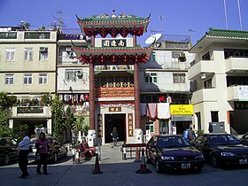
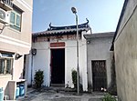
Sheung Shui Wai, also known as Sheung Shui Heung (上水鄉) is an area in Sheung Shui, in the northern part of the New Territories of Hong Kong. Its population is around 6,000 people.

<span class="mw-page-title-main">Lam Tsuen</span> Human settlement in Tai Po District, Hong Kong

Lam Tsuen is an area in Tai Po District, Hong Kong, noted for its Lam Tsuen wishing trees. The nearby Lam Tsuen River, empties into Tai Po Hoi.

<span class="mw-page-title-main">Shap Pat Heung</span> Human settlement in Hong Kong

Shap Pat Heung is an area in the New Territories of Hong Kong. Located south of Yuen Long and northeast of Tai Tong, the area occupies the plain north of hills of Tai Lam. The Cantonese name 'Shap Pat Heung' means 'eighteen villages' at its beginning. It was later expanded to thirty villages. Administratively, it is part of the Yuen Long District.

The Tang Clan of Hong Kong is one of the Five Great Clans of the New Territories (新界五大氏族). The others are Man, Hau, Pang and Liu.

<span class="mw-page-title-main">Lung Yeuk Tau</span> Area northeast of Luen Wo Hui in Fanling, New Territories, Hong Kong

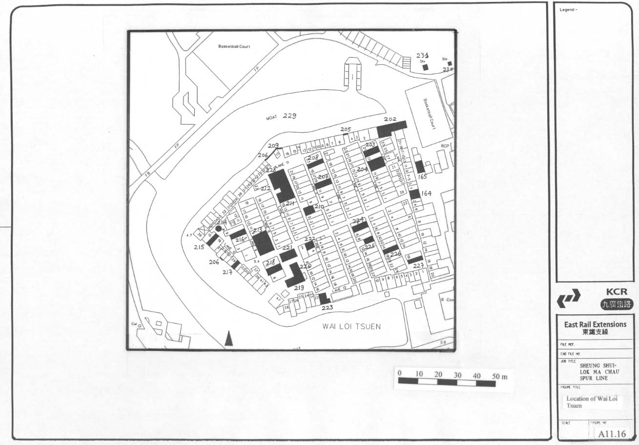
Lung Yeuk Tau, commonly known as Lung Ku Tau and also called Lung Ling is an area located northeast of Luen Wo Hui in Fanling, New Territories, Hong Kong.

<span class="mw-page-title-main">Tin Hau temples in Hong Kong</span>

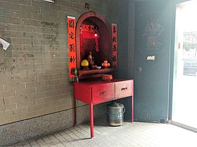
Tin Hau temples in Hong Kong are dedicated to Tin Hau (Mazu). Over 100 temples are dedicated to Tin Hau in Hong Kong. A list of these temples can be found below.

<span class="mw-page-title-main">Ying Lung Wai</span> Walled village in the Yuen Long District, Hong Kong

Ying Lung Wai is a walled village in the Yuen Long Kau Hui area of Yuen Long District, Hong Kong.

<span class="mw-page-title-main">Yuen Long Kau Hui</span> Area in Yuen Long, Yuen Long District, Hong Kong

Yuen Long Kau Hui is an area in Yuen Long, Yuen Long District, in the western New Territories of Hong Kong.

<span class="mw-page-title-main">Nam Pin Wai (Yuen Long)</span> Walled village in the Yuen Long District, Hong Kong

Nam Pin Wai, sometimes transliterated as Nam Bin Wai, is a walled village in the Yuen Long Kau Hui area of Yuen Long District, Hong Kong.

<span class="mw-page-title-main">Wing Lung Wai</span> Walled village in Hong Kong

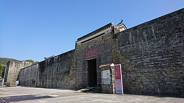
Wing Lung Wai is a walled village located in the Kam Tin area of Yuen Long District, in Hong Kong. Three other walled villages, Kat Hing Wai, Tai Hong Wai, and Kam Hing Wai are located nearby and were built around the same time.

<span class="mw-page-title-main">Tin Sam Tsuen, Sha Tin District</span> Village in Hong Kong

Tin Sam Village or Tin Sam Tsuen, sometimes transliterated as Tin Sum, is a village in Tai Wai, Sha Tin District, Hong Kong. It is located west of Sun Chui Estate, north of Lung Hang Estate, and southeast of Festival City. Part of Tin Sam Village consists of Tin Sam Wai (田心圍), a historic walled village.

<span class="mw-page-title-main">Tan Chuk Hang</span> Village in Hong Kong

Tan Chuk Hang is a village of Hong Kong, located in Fanling, North District. It comprises Tan Chuk Hang Lo Wai and Tan Chuk Hang San Wai aka. Sheung Tan Chuk Hang.

<span class="mw-page-title-main">Wing Ning Wai</span> Walled village in Lung Yeuk Tau, Fanling, Hong Kong

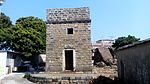
Wing Ning Wai is a walled village in Lung Yeuk Tau, Fanling, Hong Kong. It is one of the Five Wai and Six Tsuen (villages) in Lung Yeuk Tau.

<span class="mw-page-title-main">Ho Sheung Heung</span> Area in Sheung Shui, North District, Hong Kong

Ho Sheung Heung is an area in Sheung Shui, North District, Hong Kong.

<span class="mw-page-title-main">San Wai (San Tin)</span>

San Wai or San Wai Tsuen (新圍村) is a village in the San Tin area of Yuen Long District, Hong Kong.

The Nine Alliances of Lek Yuen or Kau Yeuk was a regional organization of various groups in Sha Tin Valley, Hong Kong.

References

  1. 1 2 3 4 5 6 7 8 Antiquities and Monuments Office. Lung Yeuk Tau Heritage Trail
  2. Jeffrey W. Cody and James R. Richardson (1997). "Urbanizing forest and Village Trees in Hong Kong's Sha Tin Valley, 1976–1997" (PDF). Traditional Dwellings and Settlements Review. IX (1): 24. Archived from the original (PDF) on 9 January 2016.
  3. 1 2 Hill, Ronald D. (1985). "Fragments and speculations: the walled villages of Hong Kong". Journal of the Hong Kong Archaeological Society. 11. Hong Kong Archaeological Society: 25-38. OCLC   02465191.
  4. Planning Department – Historical Background
  5. HK Yahoo News
  6. Antiquities Advisory Board. Historic Building Appraisal: Hung Shing Temple, Hung Leng Tsuen
  7. 1 2 3 Agreement No. CE 45/2008 (CE) Liantang / Heung Yuen Wai Boundary Control Point and Associated Works -Environmental Impact Assessment Report. Appendix 12.2f: Detailed Records of Identified Built Heritage Features within CHIA Study Area of the Lau Shui Heung Tunnel Section (South Tunnel)
  8. Antiquities and Monuments Office: Ma Wat Wai: Declared monument on AMO website
  9. Antiquities and Monuments Office. Lung Yeuk Tau Heritage Trail - Ma Wat Wai
  10. Antiquities and Monuments Office: Kun Lung Gate Tower: Declared monument
  11. Antiquities and Monuments Office: Kun Lung Walls
  12. Antiquities and Monuments Office. Lung Yeuk Tau Heritage Trail - San Wai
  13. Antiquities and Monuments Office. Lung Yeuk Tau Heritage Trail - Tung Kok Wai
  14. Antiquities Advisory Board. Historic Building Appraisal. Tung Kok Wai, Lung Yeuk Tau
  15. Antiquities and Monuments Office. Lung Yeuk Tau Heritage Trail. Lung Yeuk Tau Heritage Trail - Wing Ning Wai
  16. Antiquities Advisory Board. Historic Building Appraisal: Hakka Wai – Residential Houses
  17. Antiquities and Monuments Office: Ho Sheung Heung: History
  18. Lonely Planet : Ping Kong
  19. Chinese Temples Committee: Tin Hau Temple, Ping Kong
  20. Antiquities and Monuments Offices: Ha Pak Tsuen – History
  21. Christopher DeWolf, "At the end of the line: Sheung Shui Village", CNN GO, 5 May, 2010
  22. Planning Department: Fanling & Sheung Shui – Historical Background
  23. East Rail Extension Project: Test Pits Results and Cross-Section Drawings. Items #219, 220, 221 on map:
  24. Antiquities Advisory Board. Historic Building Appraisal: Entrance Gate, Tin Sam
  25. 1 2 Antiquities Advisory Board. Historic Building Appraisal: Choi Ancestral Hall, No. 142 Tin Sam
  26. Antiquities Advisory Board. Historic Building Appraisal: Che Kung Temple, Che Kung Miu Road, Tai Wai
  27. SCL – NEX/2206 EIA Study for Tai Wai to Hung Hom Section. Environmental Impact Assessment Report.Appendix 4.3. Built Heritage Survey. October 2011
  28. East Rail Extensions – Tai Wai to Ma On Shan. Environmental Impact Assessment Report. Archaeological and Cultural Resources, 1999
  29. SCL – NEX/2206 EIA Study for Tai Wai to Hung Hom Section, Final Environmental Impact Assessment Report, Figure 4.2.1. Locations of Known Built Heritages (Sheet 1 of 8), October 2011. Shows the location of the historic buildings of Tin Sam Village.
  30. 1 2 Antiquities and Monuments Office: Tai Po Tau Shui Wai
  31. Brief Information_ on proposed Grade III Items. Item #689 Archived 21 March 2012 at the Wayback Machine
  32. 1 2 3 4 5 6 7 Antiquities and Monuments Office: Tsing Chuen Wai – History
  33. Brief Information on proposed Grade III Items. Item #875 Archived 21 March 2012 at the Wayback Machine
  34. 1 2 Tuen Tsz Wai Building Complex, Hulu Culture
  35. Antiquities and Monuments Office: Tuen Tsz Wai – History
  36. Antiquities Advisory Board. Historic Building Appraisal. Yeung Hau Temple, San Wai, Ha Tsuen
  37. 1 2 "Ha Tsuen Tang Clan's Historic Building compound". Hulu Culture.
  38. 1 2 Antiquities Advisory Board. Historic Building Appraisal. Entrance Gate, Wing Lung Wai, Kam Tin
  39. 1 2 3 Antiquities and Monuments Office: Ping Shan Heritage Trail
  40. Antiquities and Monuments Office: Sheung Cheung Wai
  41. Antiquities Advisory Board. Historic Building Appraisal: Entrance Gate, Sheung Cheung Wai, Hang Tau Tsuen
  42. Brief history of Shan Ha Tsuen
  43. Introduction to 1444 Historic Buildings, p.913
  44. Antiquities Advisory Board. Historic Building Appraisal: Entrance Gate, Tai Wai Tsuen, Yuen Long
  45. Antiquities Advisory Board. Historic Building Appraisal: No. 24 Lee Yick Street, Yuen Long Kau Hui
  46. 1 2 Ip, Hing-fong (1995). An historical geography of the walled villages of Hong Kong (Postgraduate Thesis, Master of Philosophy). University of Hong Kong.
  47. Antiquities Advisory Board. Historic Building Appraisal. Entrance Gate, Pak Mong
  48. Antiquities Advisory Board. Historic Building Appraisal. Entrance Gate, Sha Lo Wan Tsuen
  49. Antiquities and Monuments Office. Lung Yeuk Tau Heritage Trail - Siu Hang Tsuen
  50. Antiquities and Monuments Office. Historic Building Appraisal. Entrance Gate, Tai Tseng Ng Uk Tsuen

Further reading