Walton and Ivythorn Hills

Last updated

Walton and Ivythorn Hills
Site of Special Scientific Interest
Viewpoint on Walton Hill.jpg
Somerset UK location map.svg
Red pog.svg
Location within Somerset
Area of Search Somerset
Grid reference ST475346
Coordinates 51°06′30″N2°45′05″W / 51.10828°N 2.75129°W / 51.10828; -2.75129 Coordinates: 51°06′30″N2°45′05″W / 51.10828°N 2.75129°W / 51.10828; -2.75129
InterestBiological
Area34.9 hectares (0.349 km2; 0.135 sq mi)
Notification 1953
Natural England website

Walton and Ivythorn Hills is a 34.9 hectares (86 acres) biological Site of Special Scientific Interest near Street at the south-eastern end of the Polden Hills in the English county of Somerset. Walton Hill is south of the village of Walton, and Ivythorn Hill is south of Street. Notified in 1953, the site is now owned and managed by the National Trust who acquired the freehold in 1988.

Contents

The hills which rise to 80 metres (260 ft) above Ordnance datum (mean sea level) are made up of limestone, rheatic clay and Keuper marl covered with calcareous grassland, scrubland and coppiced woodland. A quarry existed in the Middle Ages. This supports a variety of Butterflies, Leafhoppers, Spiders, Soldier Flies and Great Green Bush Crickets living on the vegetation. Notable buildings include Ivythorne Manor, which was originally built for Glastonbury Abbey, Walton windmill and a small sanatorium which became the first youth hostel in Somerset. In 1977 a short lived hippie camp was set up on Ivythorne Hill. The camp was a Free Festival to celebrate 7/7/77. The festival was attended by an estimated 3,000 people and was basically a one-day affair, with some people arriving early and the hangers on eventually evicted by the council. [1]

Geography

The Polden Hills a long, low ridge, extending for 10 miles (16 km), and separated from the Mendip Hills, to which they are nearly parallel, by a marshy tract, known as the Somerset Levels. The ridge is underlain by Blue Lias with alternating strata of limestone, rheatic clay and Keuper marl. [2]

At the highest point on Walton Hill, which reaches 80 metres (260 ft) above Ordnance datum (mean sea level), [2] there is a topograph or orientation stone used as a triangulation point and highlighting key features of the surrounding landscape including the Somerset Levels and the Admiral Hood Monument. [3] [4] It forms the starting point for the 6 miles (9.7 km) long footpath known as the Polden Way. [5]

History

Walton windmill The old mill on Walton Hill - geograph.org.uk - 1508528.jpg
Walton windmill

A quarry on Ivythorn Hill produced stone for Street Manor in 1403. [6] Ivythorne Manor is a Grade II* listed building which was built as a monastic dwelling in the medieval era and rebuilt in 1488 by John Selwood, Abbot of Glastonbury Abbey. It later became a country house and was revised and extended from the 16th to 20th centuries by the Marshall and Sydenham families which owned it. [7] Within the grounds is a dovecote which was probably built around 1578 for John Sydenham. [8]

Walton windmill on Walton Hill was described as "new-erected" in 1741, although there had been a mill erected on the site in 1342. [6] It was worked until 1906. [9] It is now a Grade II listed building and private residence. [10] [11] There was also a windmill on Ivythorne Hill. [12]

The shoe manufacturer C. & J. Clark, through the Society of Friends, had a small sanatorium and convalescent home on Ivythorn Hill overlooking Street. In 1931, this chalet style building was leased to the Youth Hostel Association and became the first youth hostel in Somerset. It is still used for this purpose. [13] [14]

The youth hostel Street Youth Hostel - geograph.org.uk - 1178893.jpg
The youth hostel

This site is owned and managed by the National Trust. They acquired the freehold of 0.248 hectares (0.61 acres) of Ivythorn Hill in 1988 from Street Estates, which followed 16.606 hectares (41.03 acres) of Walton Hill in 1940 from Polden Farms Ltd and the initial 18.751 hectares (46.33 acres) of Ivythorn Hill and Wood in 1919 from Baron St Audries. [15]

In 1977 Ivythorne Hill was the site of a hippie camp following summer solstice celebrations at Stonehenge. They were evicted by Mendip District Council. [16]

Ecology

Walton and Ivythorn Hills are covered by a variety of semi-natural habitats. These include unimproved calcareous grassland, scrubland and coppiced woodland including field maple and Ash. The range of habitats are home to many species of invertebrate. Butterflies, Leafhoppers, Spiders and Soldier Flies are particularly well represented. There is also a population of Great Green Bush Cricket (Tettigonia viridissima). [2]

Between 2011 and 2013 a project was undertaken to increase the population of Large blue butterflies on the Polden Hills. This included planting Wild Thyme and managing the grazing on Walton Hill. [17] [18]

Related Research Articles

Somerset County in South West England

Somerset is a county in South West England which borders Gloucestershire and Bristol to the north, Wiltshire to the east, Dorset to the south-east and Devon to the south-west. It is bounded to the north and west by the Severn Estuary and the Bristol Channel, its coastline facing southeastern Wales. Its traditional border with Gloucestershire is the River Avon. Somerset's county town is Taunton.

Street, Somerset Human settlement in England

Street is a large village and civil parish in the county of Somerset, England. The 2011 census recorded the parish as having a population of 11,805. It is situated on a dry spot in the Somerset Levels, at the end of the Polden Hills, 2 miles (3.2 km) south-west of Glastonbury. There is evidence of Roman occupation. Much of the history of the village is dominated by Glastonbury Abbey until the Dissolution of the Monasteries, and a 12th-century causeway from Glastonbury was built to transport local Blue Lias stone from what is now Street to rebuild the Abbey.

Polden Hills

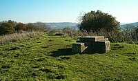
Polden Hills in Somerset, England are a long, low ridge, extending for 10 miles (16 km), and separated from the Mendip Hills, to which they are nearly parallel, by a marshy tract, known as the Somerset Levels. They are now bisected at their western end by the M5 motorway and a railway, the Bristol and Exeter Railway, part of the Great Western Main Line.

Shapwick, Somerset Human settlement in England

Shapwick is a village on the Polden Hills overlooking the Somerset Moors, in the Sedgemoor district of Somerset, England. It is situated to the west of Glastonbury.

St Cuthbert Out Human settlement in England

St Cuthbert Out, sometimes Wells St Cuthbert Out, is a civil parish in the Mendip district of Somerset, England. It entirely surrounds the city and parish of Wells. According to the 2011 census it had a population of 3,749.

Dolebury Warren

Dolebury Warren is a 90.6 hectares biological Site of Special Scientific Interest (SSSI) and ancient monument near the villages of Churchill and Rowberrow in North Somerset, part of South West England. It is owned by the National Trust, who acquired the freehold in 1983, and managed by the Avon Wildlife Trust.

Draycott Sleights

Draycott Sleights is a 61.95 hectares biological Site of Special Scientific Interest at Draycott in the Mendip Hills, Somerset, England, notified in 1987. The name is pronounced locally as "Slates", presumably a variation on the Saxon word Slade meaning amongst other things hillside, rather than in the same manner as the Yorkshire place of the same spelling.

Great Breach and Copley Woods

Great Breach and Copley Woods is a 64.8 hectare biological Site of Special Scientific Interest 1 km south of Compton Dundon and 5 km south-east of Street in Somerset, England, notified in 1972.

Meare Human settlement in England

Meare is a village and civil parish 3 miles (4.8 km) north west of Glastonbury on the Somerset Levels, in the Mendip district of Somerset, England. The parish includes the village of Westhay.

Walton, Somerset Human settlement in England

Walton is a village and civil parish, on the Polden Hills, 1.5 miles (2.4 km) west of Street in the Mendip district of Somerset, England. The parish includes the hamlet of Asney.

West Pennard Human settlement in England

West Pennard is a village and civil parish east of Glastonbury, situated at the foot of Pennard Hill, in the Mendip district of Somerset, England. The parish includes the hamlets of Coxbridge and Woodlands.

Moorlinch Human settlement in England

Moorlinch is a village and civil parish where the Polden Hills meet the Somerset Levels in the Sedgemoor district of Somerset, England.

Mendip is a local government district in the English county of Somerset. The Mendip district covers a largely rural area of 285 square miles (738 km2) ranging from the Mendip Hills through on to the Somerset Levels. It has a population of approximately 11,000. The administrative centre of the district is Shepton Mallet.

The Abbots Fish House, Meare Grade I listed building and Scheduled Ancient Monument in Meare, Somerset, England

The Abbot's Fish House in Meare, Somerset, England, was built in the 14th century and has been designated as a Grade I listed building and Scheduled Ancient Monument. It is the only surviving monastic fishery building in England.

Manor Farmhouse, Meare

The Manor Farmhouse in Meare, Somerset, England, was built in the 14th century as the summer residence of the Abbots from Glastonbury Abbey and is now a farmhouse. Along with its outbuildings the farmhouse has been designated as a Grade I listed building.

Geography of Somerset

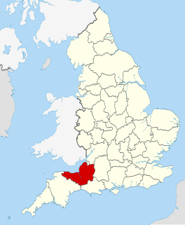
The county of Somerset is in South West England, bordered by the Bristol Channel and the counties of Bristol and Gloucestershire to the north, and Wiltshire to the east, Dorset to the south, and Devon to the west. The climate, influenced by its proximity to the Atlantic Ocean and the prevailing westerly winds, tends to be mild, damp and windy.

Scheduled monuments in Mendip

Mendip is a local government district of Somerset in England. The Mendip district covers a largely rural area of 285 square miles (738 km2) ranging from the Mendip Hills through on to the Somerset Levels. It has a population of approximately 110,000. The administrative centre of the district is Shepton Mallet but the largest town is Frome.

References

  1. "Glastonbury free festival 1977".
  2. 1 2 3 "Walton and Ivythorn Hills SSSI citation sheet" (PDF). English Nature. Retrieved 24 May 2015.
  3. "TP9460 - Walton Hill". Trig Pointing UK. Retrieved 24 May 2015.
  4. "Assessment of Special Landscape Features". Mendip District Council. Retrieved 25 May 2015.
  5. "The heart of the West: a land of heroes and windmills". Western Daily Press. 3 February 2011. Retrieved 25 May 2015.
  6. 1 2 Siraut, M.C; Thacker, A.T.; Wliiamson, Elizabeth. "Parishes: Walton. A History of the County of Somerset: Volume 9, Glastonbury and Street". British History Online. Victoria County History. Retrieved 24 May 2015.
  7. Historic England. "Ivythorn Manor (1176171)". National Heritage List for England . Retrieved 25 May 2015.
  8. Historic England. "Dovecote in Grounds East of Ivythorn Manor (1345094)". National Heritage List for England . Retrieved 25 May 2015.
  9. Coulthard, Alfred J, and Watts, Martin (1978). Windmills of Somerset and the men who worked them. London: The Research Publishing Co. p. 62. ISBN   0-7050-0060-5.
  10. Historic England. "Walton Windmill (1058724)". National Heritage List for England . Retrieved 8 February 2009.
  11. Historic England. "Walton Windmill (1058724)". National Heritage List for England . Retrieved 24 May 2015.
  12. "Windmill site, Ivy Thorn Wood, Street". Somerset Historic Environment Record. Somerset County Council. Retrieved 25 May 2015.
  13. "Youth Hostel, Street". Youth Hostel Association. Retrieved 24 May 2015.
  14. Siraut, M. C.; Thacker, A. T.; Williamson, Elizabeth. "Parishes: Street In A History of the County of Somerset: Volume 9, Glastonbury and Street". British History Online. Victoria County History. Retrieved 25 May 2015.
  15. "Acquisitions Up to December 2011" (PDF). National Trust. Retrieved 24 May 2015.
  16. "Looking Back: Calls for army to deal with Street Hill hippy invasion in 1977". Central Somerset Gazette. 7 September 2014. Retrieved 25 May 2015.
  17. "Expanding the Large Blue Landscape in the Polden Hills. Project Update" (PDF). Butterfly Conservation. Retrieved 24 May 2015.
  18. "Large Blue butterfly at Collard Hill". National Trust. Retrieved 25 May 2015.