Ebbor Gorge

Last updated

Ebbor Gorge
Site of Special Scientific Interest
EbborGorge.jpg
Somerset UK location map.svg
Red pog.svg
Location within Somerset
Location Somerset
Grid reference ST525485
Coordinates 51°14′02″N2°40′55″W / 51.234°N 2.682°W / 51.234; -2.682 Coordinates: 51°14′02″N2°40′55″W / 51.234°N 2.682°W / 51.234; -2.682
InterestBiological
Area156.8 acres (0.635 km2; 0.2450 sq mi)
Notification 1952
Natural England website

Ebbor Gorge is a limestone gorge in Somerset, England, designated and notified in 1952 as a 63.5-hectare (157-acre) biological Site of Special Scientific Interest in the Mendip Hills. It was donated to the National Trust in 1967 and is now managed by Natural England as a national nature reserve.

Contents

The gorge was cut mostly into the Clifton Down Limestone, part of the Lower Carboniferous Pembroke Group, by water. The site was occupied by humans in the Neolithic Era and their tools and flint arrow heads have been discovered, along with pottery from the Bronze Age. There are also fossils of small mammals from the Late Devensian. The nature reserve provides a habitat for a variety of flora and fauna, including flowers, butterflies and bats.

Geology

Ebbor Gorge lies on the southwest-facing slope of the Mendip Hills and consists of a steep-sided ravine cut into 350-million-year-old Carboniferous Limestone of the Dinantian. The gorge was cut into Clifton Down Limestone by meltwater in the Pleistocene Epoch. [1] [2] The lowest part of the gorge is formed in the Namurian Quartzitic Sandstone Group and the South Wales Lower Coal Measures, over which younger limestones have been thrust to the north-east, as demonstrated by the BGS maps (1:50,000 sheet 280, Wells). An example of the rare mineral mendipite was found at the head of the gorge. [3]

A stream issuing to the west of the site runs down the tributary valley of Hope Wood before joining the main gorge. The original watercourse which may have cut the gorge into the limestone became diverted underground and now emerges at Wookey Hole Caves to form the River Axe. [4]

History

Various caves within the gorge were inhabited by neolithic people from which flint tools are held in the Wells and Mendip Museum. [5] [6] [7] One particularly fine flint flake can be seen in the museum at King John's Hunting Lodge in Axbridge. [8] Human and animal bones from the Neolithic were recovered from Outlook Cave in 1907. [9] Bones from the Palaeolithic have been found at Savory's Hole. [10]

Several caves occur within the Gorge, of which Bridged Pot and Gully Cave provide some of the best Late Devensian small-mammal assemblages known from Britain. Most of the deposits remain in situ and include steppe pika, Arctic lemming, Norway lemming, various voles, red deer and reindeer. [11] [12] [13] [14] Bronze Age finds include pottery from the Beaker culture, [15] a stone axe and flint knife. [16]

Current use

Plaque at Ebbor Gorge commemorating the donation of the land Ebborgrogeplaque.jpg
Plaque at Ebbor Gorge commemorating the donation of the land

A 40-hectare (99-acre) area of the gorge is owned by the National Trust, and managed by Natural England as a national nature reserve. [17] [18] The land was donated to the National Trust by Mrs G.W. Hodgkinson, in 1967, in memory of Winston Churchill. [19] The site was purchased in 1931 by Wookey Hole Caves Ltd. [20]

The site is close to Wookey Hole village and caves and offers views across the Somerset Levels to Glastonbury Tor and beyond. There are three marked trails of varying lengths around the steeply wooded gorge, the longest being 3 kilometres (1.9 mi) long, [7] the shortest of which is suitable for wheelchair users. [21]

Biology and ecology

The path into the gorge Ebbor Gorge 2.jpg
The path into the gorge

Because of the ecology of the area 63.5 hectares (157 acres) was designated as a biological Site of Special Scientific Interest in 1952. [11] The ground flora is indicative of the calcareous nature of the site, with dog's mercury (Mercurialis perennis) being locally dominant. Many of the associated species are characteristic of ancient woodland. Wood anemone (Anemone nemorosa) and common bluebell (Hyacinthoides non-scripta) are both locally abundant. The valley of the main gorge is humid and provides ideal conditions for fungi and ferns. It contains a substantial assemblage of bryophytes with over 120 species recorded including the nationally rare Bryum canariense and the very rare Amblystegiella confervoides . [11]

The varied age and canopy structure of woodland encourages a high diversity of butterflies, nationally scarce species including the white-letter hairstreak (Strymonidia walbum) and high brown fritillary (Fabriciana adippe), while species such as the chalkhill blue (Lysandra coridon) and brown argus (Aricia agestis) occur on the limestone grassland. [22] Greater horseshoe bats (Rhinolophus ferrumequinum) and lesser horseshoes (Rhinolophus hipposideros) regularly use sites in the Gorge as hibernacular roosts. [11] The site also supports birds of prey and a few red deer. [23]

Related Research Articles

Cheddar, Somerset Human settlement in England

Cheddar is a large village and civil parish in the Sedgemoor district of the English county of Somerset. It is situated on the southern edge of the Mendip Hills, 9 miles (14 km) north-west of Wells, 11 miles (18 km) south-east of Weston-super-Mare and 18 miles (29 km) south-west of Bristol. The civil parish includes the hamlets of Nyland and Bradley Cross. The parish had a population of 5,755 in 2011 and an acreage of 8,592 acres (3,477 ha) as of 1961.

Wookey Hole Caves Series of limestone caverns in Somerset county, England

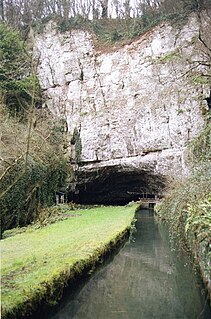
Wookey Hole Caves are a series of limestone caverns, a show cave and tourist attraction in the village of Wookey Hole on the southern edge of the Mendip Hills near Wells in Somerset, England. The River Axe flows through the cave. It is a Site of Special Scientific Interest (SSSI) for both biological and geological reasons. Wookey Hole cave is a "solutional cave", one that is formed by a process of weathering in which the natural acid in groundwater dissolves the rocks. Some water originates as rain that flows into streams on impervious rocks on the plateau before sinking at the limestone boundary into cave systems such as Swildon's Hole, Eastwater Cavern and St Cuthbert's Swallet; the rest is rain that percolates directly through the limestone. The temperature in the caves is a constant 11 °C (52 °F).

Cheddar Gorge Valley in Somerset, England

Cheddar Gorge is a limestone gorge in the Mendip Hills, near the village of Cheddar, Somerset, England. The gorge is the site of the Cheddar show caves, where Britain's oldest complete human skeleton, Cheddar Man, estimated to be 9,000 years old, was found in 1903. Older remains from the Upper Late Palaeolithic era have been found. The caves, produced by the activity of an underground river, contain stalactites and stalagmites. The gorge is part of a Site of Special Scientific Interest called Cheddar Complex.

Mendip Hills Range of limestone hills to the south of Bristol and Bath in Somerset, England

The Mendip Hills is a range of limestone hills to the south of Bristol and Bath in Somerset, England. Running from Weston-super-Mare and the Bristol Channel in the west to the Frome valley in the east, the hills overlook the Somerset Levels to the south and the Chew Valley and other tributaries of the Avon to the north. The hills give their name to the local government district of Mendip, which administers most of the area. The higher, western part of the hills, covering 198 km2 (76 sq mi) has been designated an Area of Outstanding Natural Beauty (AONB), which gives it a level of protection comparable to a national park.

River Axe (Bristol Channel) River in Somerset, England

The River Axe is a river in South West England. The river is formed by water entering swallets in the limestone and rises from the ground at Wookey Hole Caves in the Mendip Hills in Somerset, and runs through a V-shaped valley. The geology of the area is limestone and the water reaches Wookey Hole in a series of underground channels that have eroded through the soluble limestone. The river mouth is in Weston Bay on the Bristol Channel.

Geology of Somerset

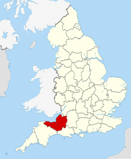
Somerset is a rural county in the southwest of England, covering 4,171 square kilometres (1,610 sq mi). It is bounded on the north-west by the Bristol Channel, on the north by Bristol and Gloucestershire, on the north-east by Wiltshire, on the south-east by Dorset, and on the south west and west by Devon. It has broad central plains with several ranges of low hills. The landscape divides into four main geological sections from the Silurian through the Devonian and Carboniferous to the Permian which influence the landscape, together with water-related features.

Priddy Human settlement in England

Priddy is a village in Somerset, England in the Mendip Hills, close to East Harptree and 4 miles (6 km) north-west of Wells. It is in the local government district of Mendip.

Brimble Pit and Cross Swallet Basins is a 154.3 hectare geological Site of Special Scientific Interest between Wookey Hole and Priddy in the Mendip Hills, Somerset, notified in 1987.

Crook Peak to Shute Shelve Hill Geological and biological Site of Special Scientific Interest in Somerset, England

Crook Peak to Shute Shelve Hill is a 332.2 hectare (820.9 acre) geological and biological Site of Special Scientific Interest near the western end of the Mendip Hills, Somerset. The line of hills runs for approximately 5 kilometres (3.1 mi) from west to east and includes: Crook Peak, Compton Hill, Wavering Down, Cross Plain and Shute Shelve Hill. Most of the site is owned by the National Trust, which bought 725 acres (293 ha) in 1985, and much of it has been designated as common land. It was notified as an SSSI by Natural England in 1952.

King Johns Hunting Lodge, Axbridge Wool-merchants house in Axbridge, built c. 1460

King John's Hunting Lodge is a wool-merchant's house built c. 1460, long after the death of King John in 1216, in Axbridge, a town in the English county of Somerset. It is a jettied timber-frame building of three storeys, occupying a corner plot on the town square. The building has served a variety of purposes with shops on the ground floor and workshops and living quarters on the first and second floors. At one time part of the building was occupied by the King's Head Inn; a sculpture of a king's head, which acted as a sign for the pub, is preserved within and a replica is attached to the outside. The lodge was bequeathed to the National Trust in 1971, and repairs were undertaken to reverse significant deterioration to the building.

Cheddar Complex Site of Special Scientific Interest in Somerset, England

The Cheddar Complex is a 441.3 hectare biological Site of Special Scientific Interest near Cheddar around the Cheddar Gorge and north east to Charterhouse in the Mendip Hills, Somerset, England, notified in 1952.

Charterhouse, Somerset Human settlement in England

Charterhouse, also known as Charterhouse-on-Mendip, is a hamlet in the Mendip Hills Area of Outstanding Natural Beauty (AONB) in the English county of Somerset. The area between Charterhouse and Cheddar Gorge including Velvet Bottom and Ubley Warren is covered by the Cheddar Complex Site of Special Scientific Interest.

Caves of the Mendip Hills

The caves of the Mendip Hills are formed by the particular geology of the Mendip Hills: large areas of limestone worn away by water makes it a national centre for caving. The hills conceal the largest underground river system in Britain.

St Cuthberts Swallet Cave in the Mendip Hills, Somerset, England

St Cuthbert's Swallet is the second longest, and most complex, cave on the Mendip Hills, in Somerset, England. It forms a major part of the Priddy Caves system and water entering this swallet re-emerges at Wookey Hole. St Cuthbert's Swallet is part of, and lies underneath, the Priddy Pools Site of Special Scientific Interest.

Wookey Hole Human settlement in England

Wookey Hole is a village in Somerset, England. It is the location of the Wookey Hole show caves.

The Mendip Way is an 80-kilometre (50 mi) long-distance footpath across the Mendip Hills from Weston-super-Mare to Frome. It is divided into two sections.

Geography of Somerset

The county of Somerset is in South West England, bordered by the Bristol Channel and the counties of Bristol and Gloucestershire to the north, and Wiltshire to the east, Dorset to the south, and Devon to the west. The climate, influenced by its proximity to the Atlantic Ocean and the prevailing westerly winds, tends to be mild, damp and windy.

Cheddar Yeo River in Somerset, England

The Cheddar Yeo is a small river in Somerset, England. Beneath the limestone of the Mendip Hills it forms the largest underground river system in Britain. After emerging into Cheddar Gorge it flows through the village of Cheddar, where it has been used in the past to power mills. From the Middle Ages until the 19th century the river had ports for seagoing vessels but is no longer navigable. Some of the water, which is of good quality, is diverted into Cheddar Reservoir to provide drinking water for Bristol.

Picken's Hole is a small cave on the southern side of Crook Peak in the Mendip Hills in the English county of Somerset. It has been designated as a scheduled monument. It has sometimes been confused with a nearby cave called Scragg's Hole, including by the Somerset Historic Environment Record.

References

  1. "Wookey Hole and Ebbor Gorge". British Geological Survey. Retrieved 22 December 2013.
  2. Donovan, D.T. (1988). "The late pleistocene sequence at Wells, Somerset" (PDF). Proceedings of the University of Bristol Speleological Society. 18 (2): 241–257.
  3. Toulson, Shirley (1984). The Mendip Hills: A Threatened Landscape. Victor Gollanz Ltd. p. 32. ISBN   978-0-575-03453-2.
  4. Smith, David Ingle (1975). Limestone and Caves of the Mendip Hills. David & Charles. p. 120. ISBN   978-0-7153-6572-4.
  5. Lewis, Jodie (1998). "The Everton flint collection in Wells Museum" (PDF). Proceedings of the University of Bristol Speleological Society. 21 (2): 141–148.
  6. Brown, Graham. "Dispersed settlements on the southern Mendip escarpment. The earthwork evidence" (PDF). Research Department Report Series no 72-2008. English Heritage. Archived from the original (PDF) on 24 December 2013. Retrieved 22 December 2013.
  7. 1 2 "Ebbor Gorge NNR". Natural England. Retrieved 19 May 2014.
  8. Bond, Clive Jonathon (2013). "The later upper palaeolithic open sites and settlement trajectories. The evidence from the Mendip Hills, south-west Britain". Notae Praehistoricae. 33: 179–192.
  9. Historic England. "Outlook Cave (1010711)". National Heritage List for England . Retrieved 15 February 2015.
  10. Historic England. "Savory's Hole (1012061)". National Heritage List for England . Retrieved 22 February 2015.
  11. 1 2 3 4 "Ebbor Gorge" (PDF). English Nature. Retrieved 22 December 2013.
  12. Papworth, Martin. "Deep Time in Ebbor Gorge". Archeology. National Trust. Retrieved 22 December 2013.
  13. "Wolves and wildcats: surviving the end of the last ice age in Somerset". Harrow and Hillingdon Geological Society. Retrieved 19 May 2014.
  14. "Learning & Leading Fieldwork Apprentices" (PDF). Royal Geographical Society. Retrieved 19 May 2014.
  15. "Bridged Pot Shelter, Ebbor Gorge, Wookey, Somerset". A Gazetteer of English Caves, Fissures and Rock Shelters Containing Human Remains. University of Sheffield. Archived from the original on 4 February 2012. Retrieved 22 December 2013.
  16. "Bridged Pot Hole, Ebbor Gorge". Somerset Historic Environment Record. Somerset County Council. Retrieved 4 October 2014.
  17. "Ebbor Gorge NNR". Natural England. Archived from the original on 5 June 2014. Retrieved 31 January 2010.
  18. "Things to see and do". National Trust. Retrieved 21 December 2013.
  19. Leete-Hodge, Lornie (1985). Curiosities of Somerset. Bodmin: Bossiney Books. p. 24. ISBN   0-906456-98-3.
  20. "Beauty Spot Known to Few Bristolians" . Western Daily Press. 17 July 1931. p. 4. Retrieved 4 October 2014 via British Newspaper Archive.
  21. Toulson, Shirley (1984). The Mendip Hills: A Threatened Landscape. Victor Gollanz Ltd. pp. 128–129. ISBN   978-0-575-03453-2.
  22. "Ebbor Gorge". United Kingdom Butterfly Monitoring Scheme. Archived from the original on 19 May 2014. Retrieved 19 May 2014.
  23. Toulson, Shirley (1984). The Mendip Hills: A Threatened Landscape. Victor Gollanz Ltd. p. 128. ISBN   978-0-575-03453-2.