Washington Avenue (Minneapolis)

Last updated
Washington Avenue
County 152 (MN).svg
North end Lyndale Ave at N 41st Ave, Minneapolis
South end Hennepin County 152.svg Cedar Avenue (Washington Ave SE continues east of river)

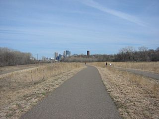
Washington Avenue is a major thoroughfare in Minneapolis, Minnesota. Starting north of Lowry Avenue, the street runs straight south, with Interstate 94 running alongside it until just south of West Broadway, when the freeway turns to the west. Washington continues running straight until just south of Plymouth Avenue, where it turns in a southeasterly direction heading for Downtown Minneapolis. It forms the main thoroughfare through the Warehouse District.

Interstate 94 Interstate across upper Midwest

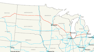
Interstate 94 (I-94) is an east–west Interstate Highway connecting the Great Lakes and northern Great Plains regions of the United States. Its western terminus is in Billings, Montana, at a junction with I-90; its eastern terminus is in Port Huron, Michigan, where it meets with I-69 and crosses the Blue Water Bridge into Sarnia, Ontario, Canada, where the route becomes Ontario Highway 402. It thus lies along the primary overland route from Seattle to Toronto, and is the only east–west Interstate highway to form a direct connection into Canada.

North Loop, Minneapolis Neighborhood in Hennepin, Minnesota, United States

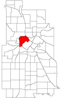
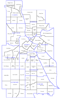
The North Loop is a neighborhood of the Central community of Minneapolis, Minnesota. The neighborhood is commonly known as the Warehouse District from the city's shipping hub years. It includes the Minneapolis Warehouse Historic District which is listed on the National Register of Historic Places. The North Loop is located just northwest of the central business district between downtown Minneapolis and the Mississippi River. Streets in the North Loop are oriented to be parallel to the river, which means that they run at a 45-degree angle relative to the grid of the rest of the city.

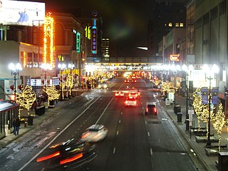
The scenery changes at Hennepin Avenue. This area, once known as the Gateway District, was heavily affected by urban renewal policies of the 1950s, destroying what had at one point been the heart of the city. Dozens of city blocks were bulldozed and replaced with modern glass structures - or in many cases, surface parking lots. The portion of the street from Hennepin to what is now Interstate 35W was widened and a median was added.

Hennepin Avenue street in Minneapolis, Minnesota

Hennepin Avenue is a major street in Minneapolis, Minnesota, United States. It runs from Lakewood Cemetery, north through the Uptown District of Southwest Minneapolis, through the Virginia Triangle, the former "Bottleneck" area west of Loring Park. It then goes through the North Loop in the city center, to Northeast Minneapolis and the city's eastern boundary, where it becomes Larpenteur Avenue as it enters Lauderdale in Ramsey County at Highway 280. Hennepin Avenue is a Minneapolis city street south/west of Washington Avenue, and is designated as Hennepin County Road 52 from Washington Avenue to the county line.

Gateway District (Minneapolis) Human settlement in Minneapolis, Minnesota, US

The Gateway District of Minneapolis is centered at the convergence of Hennepin Avenue, Nicollet Avenue, and Washington Avenue. Its borders are not officially designated or recognized, but are visible as the Mississippi River to the northeast, First Avenue North to the northwest, Fifth Avenue South to the southeast. and Fourth Street South to the southwest. The district includes a significant part of the Downtown West neighborhood and five blocks of the North Loop.

Interstate 35W (I-35W) is an Interstate Highway in the U.S. state of Minnesota, passing through downtown Minneapolis. It is one of two through routes for I-35 through the Twin Cities of Minneapolis and Saint Paul, the other being I-35E through downtown Saint Paul. I-35 splits into two branch routes: I-35W, which serves Minneapolis, and I-35E, which serves Saint Paul.

Further changes occurred to the east of the Interstate. Washington used to turn at the Seven Corners intersection (where Washington meets Cedar Avenue) and continue across the old Washington Avenue Bridge into Southeast Minneapolis. However, the old bridge was replaced in the 1960s with a new one which meets Washington east of the Mississippi River but doesn't connect with Washington west of it, instead connecting to a short freeway stub into downtown. There is a one-block portion of the old alignment between Cedar and 19th Avenues that is branded as Washington Avenue, but to continue east of the river, one must travel down Cedar one block and turn east at 3rd Street and get on an entrance ramp to the bridge.

Cedar Avenue is a roadway that runs from Minneapolis to Northfield, Minnesota. It is Minnesota State Highway 77 in the busiest portion of the route, from Minneapolis to Apple Valley. The portions north and south of this are county roads, Hennepin County 152 and Dakota County 23, respectively. Its northern terminus in Minneapolis is at Washington Avenue in Cedar-Riverside, though its alignment is briefly interrupted by an interchange at Hiawatha Avenue to the south.

Washington Avenue Bridge (Minneapolis) bridge in Minneapolis, Minnesota

The Washington Avenue Bridge carries County Road 122 and the METRO Green Line light rail across the Mississippi River in Minneapolis, Minnesota and connects the East Bank and West Bank portions of the University of Minnesota's main campus. The bridge has two decks, with the lower deck designated for motor vehicle traffic and light rail trains and the upper deck used for pedestrians and bicycles. It is a utilitarian structure with simple architecture, but it has cultural significance because thousands of students, faculty, staff, and visitors walk across it every day.

County Road 122 (Hennepin County, Minnesota) highway in Hennepin County, Minnesota

Hennepin County Road 122 or County State-Aid Highway 122 is an unsigned county state-aid highway within the city of Minneapolis, Hennepin County, Minnesota, United States, crossing the Mississippi River on the Washington Avenue Bridge.

East of the river, Washington Avenue acts as a major thoroughfare through the University of Minnesota campus; much of this section has been converted to a transit mall to facilitate the METRO Green Line, opened in June 2014. At the intersection of Oak Street and Washington is the Stadium Village area. The street continues east for a few more blocks before ending at University Avenue.

Transit mall urban street reserved for public transit vehicles, bicycles, and pedestrians

A transit mall is a street, or set of streets, in a city or town along which automobile traffic is prohibited or greatly restricted and only public transit vehicles, bicycles, and pedestrians are permitted.

Stadium Village, Minneapolis commercial district in Minneapolis, Minnesota, USA

Stadium Village is an area of Minneapolis, Minnesota near the East Bank campus of the University of Minnesota. While not an official neighborhood of Minneapolis, the area is an important commercial district that serves university students with many bars and restaurants. There are plans to incorporate it into an official neighborhood of Minneapolis along with the surrounding area. It is part of Southeast Minneapolis, that part of Minneapolis on the East Bank of the Mississippi River and south of Hennepin Avenue

The city and Minneapolis mayor R. T. Rybak have assembled a design team who propose a park, trees and a 10-year action plan for the avenue. [1]

R. T. Rybak American politician

Raymond Thomas "R. T." Rybak Jr. is an American politician, journalist, businessperson, and activist who served as the 46th mayor of Minneapolis. In the 2001 election Rybak defeated incumbent Sharon Sayles Belton by a margin of 65% to 35%, the widest margin of victory over an incumbent mayor in city history. He took office in January 2002, and won a second term in 2005 and a third in 2009. In late December 2012, he announced he would not run for another term and was going to be concentrating on his family. Rybak called being mayor his "dream job."

Notes

  1. VanDerVeen, Kari (2007-06-25). "Mayor Rybak's Great City Design Team releases vision for a Washington Boulevard". Downtown Journal. Minnesota Premier Publications. and Collins, Terry (2007-06-12). "Washington Avenue: A makeover plan with a touch of Paris". Star Tribune. Avista Capital Partners. and "The Washington Boulevard Great City Design Team". American Institute of Architects Minnesota (AIA Minnesota). Retrieved 2007-06-30.

Related Research Articles

Minnesota State Highway 36 is a highway in Minnesota, which runs from its interchange with Interstate 35W in Roseville and continues east to its eastern terminus at the Wisconsin state line, where it becomes Wisconsin Highway 64 upon crossing the St. Croix River at the St. Croix Crossing bridge. A portion of Highway 36 is a major freeway in suburban Minneapolis – Saint Paul.

Minnesota State Highway 65 is a highway in the east–central and northeast parts of the U.S. state of Minnesota, which starts at its split from I-35W, skipping past the downtown Minneapolis core, only to resume at the intersection with Washington Avenue at the north end of downtown Minneapolis to continue north to its northern terminus at its intersection with U.S. Highway 71 (US 71) in Littlefork near International Falls.

Neighborhoods of Minneapolis One of the 81 official neighborhoods of Minneapolis

The city of Minneapolis, Minnesota is officially defined by the Minneapolis City Council as divided into eleven communities, each containing multiple official neighborhoods. Informally, there are city areas with colloquial labels. Residents may also group themselves by their city street suffixes, North, Northeast, South, Southeast, and Southwest.

Interstate 395 (I-395) is an Interstate Highway in the U.S. state of Maryland. Known as Cal Ripken Way, the highway runs 1.33 miles (2.14 km) from I-95 north to Howard Street and Camden Street in Baltimore. I-395 is a spur that heads north from I-95 over the Middle Branch of the Patapsco River toward Downtown Baltimore, where it provides access to the Inner Harbor and the Baltimore Convention Center. The Interstate also serves the Camden Yards Sports Complex, which contains M&T Bank Stadium and Oriole Park at Camden Yards, homes of the Baltimore Ravens and Baltimore Orioles, respectively. I-395 also serves as the southern terminus of Martin Luther King Jr. Boulevard, an urban arterial that provides a western bypass of downtown Baltimore and connects I-95 with U.S. Route 40, US 1, and I-83. The Interstate is maintained by the Maryland Transportation Authority (MDTA) and, like all Interstates, is a part of the National Highway System.

Minnesota State Highway 77 (MN 77) is a highway in Minnesota, which runs from its intersection with 138th Street in Apple Valley and continues north to its northern terminus at its interchange with State Highway 62 in Minneapolis. The route is 11 miles (18 km) in length. MN 77 is also known as Cedar Avenue.

Harbor Drive


Harbor Drive is a short roadway in Portland, Oregon, functioning mainly as a ramp to and from Interstate 5. It was once much longer, running along the western edge of the Willamette River in the downtown area. Most of the road was replaced with Tom McCall Waterfront Park in the 1970s. Signed as U.S. Route 99W, it had been the major route through the city and its removal is often cited as the first instance of freeway removal in the USA and as a milestone in urban planning.

Lake Street (Minneapolis) street in Minneapolis, Minnesota

Lake Street is a major east-west thoroughfare in Minneapolis, Minnesota which is located between 29th and 31st Streets in south Minneapolis. It was named such because it runs through the Chain of Lakes area on the west side of town and passes over a small channel linking Lake Calhoun and Lake of the Isles.

Cedar Lake Trail

The Cedar Lake Regional Trail is America's first bicycle freeway. It is a rail trail that runs about 4.3 miles (6.9 km) from downtown Minneapolis, Minnesota (44°59′11″N 93°16′01″W) west to Minnesota State Highway 100 in the neighboring suburb of St. Louis Park(44°57′43″N 93°20′36″W). The trail was inaugurated on February 17, 1995. At the trail's west end, pavement continues for another 4.2 miles (6.8 km) as the Hutchinson Spur Trail through St. Louis Park to Hopkins. In 2009, the "Hutch Spur" was renamed "North Cedar Lake Trail." The two trails are paved for their entire lengths.

Midtown Greenway

The Midtown Greenway is a 5.7-mile (9.2 km) rail trail in Minneapolis, Minnesota. It is considered under segregated cycle facilities.

Foothill Boulevard is a major road in the city and county of Los Angeles, as well as an arterial road in the city and county of San Bernardino, stretching well over 60 miles (97 km) in length, with some notable breaks along the route. Like its name implies, Foothill Boulevard runs across the foothills of the San Gabriel and San Bernardino Mountains.

Minnesota State Highway 280 is a highway in the Twin Cities region of Minnesota that runs from its interchange with Interstate 94 in Saint Paul to its interchange with Interstate 35W in Roseville. The route is about 4 miles (6.4 km) long.

Minnesota State Highway 101 is a state highway in the U.S. state of Minnesota. The present day route currently has three separate segments. The roadway was a continuous route until 1988.

U.S. Highway 52 enters the state of Minnesota at the unincorporated community of Prosper, north of the town of Burr Oak, Iowa. The route is marked north–south in Minnesota along its independent segment from the Iowa state line to downtown St. Paul. Highway 52 is not signed along the length of its concurrency with Interstate 94 (I-94) from downtown St. Paul to the North Dakota state line at Moorhead and Fargo.

Hennepin County, Minnesota, United States maintains a number of county roads, many of them county state aid highways (CSAH). This includes a number of streets through the city of Minneapolis.

Interstate 90 Business may refer to several business routes of the Interstate Highway System that connects Interstate 90 with the central business district of various cities bypassed by I-90. Each business route can be either a business loop or a business spur, depending on whether both ends connect to I-90. The business route in each community is considered a unique route. In many cases, these routes are a former section of a U.S. Route.

Lyndale Avenue is a major street in Minneapolis, Brooklyn Center, Richfield, and Bloomington, Minnesota, in the United States. A noncontinuous portion exists in Faribault, part of Highway 21. There are several commercial districts along it, including Lyn-Lake in South Minneapolis, Shops at Lyndale in Richfield, and the Oxboro area in Bloomington. Portions of both Interstate 94 and Interstate 35 run on the right-of-way of Lyndale Avenue.