Weather lore

Last updated
Cumulus humilis indicates a dry day ahead. Bluesky.jpg
Cumulus humilis indicates a dry day ahead.

Weather lore is the body of informal folklore related to the prediction of the weather and its greater meaning.

Contents

Much like regular folklore, weather lore is passed down through speech and writing from normal people without the use of external measuring instruments. The origin of weather lore can be dated back to primeval men and their usage of star studying in navigation. [1] However, more recently during the Late Middle Ages, the works of two Greek philosopher-poets, Theophrastus of Eresus on Lesbos and Aratus of Macedonia, are known for shaping the prediction of weather. Theophrastus and Aratus collated their works in two main collections for weather lore: On Weather Signs and On Winds. These were used for helping farmers with harvest, merchants for trade and determining the weather the next day. [2]

Astrology and weather lore have been closely interlinked for many years - with each planet often being associated with a weather state. For example, Mars is red and must therefore be hot and dry. Prevalent in ancient Roman thought, astrologists used weather lore to teach commoners of the star and cloud formations and how they can be used to see the future. [2] From this, three main schools of weather lore thoughts developed during the Late Middle Ages as Astrology became more popular throughout Europe. [3] One which related to winds and clouds and had some scientific basis. A second type connected with saints' days possessed doubtful validity but was quite popular nonetheless during the Middle Ages. A third type treated the behaviour of birds and animals, which has been found to be controlled more by past and present weather rather than to be a true indication of the future. [1]

Before the invention of temperature measuring devices, such as the mercury thermometer, it was difficult to gather predictive, numerical data. Therefore, communities used their surroundings to predict and explain the weather in upcoming days. [4]

Today, the majority of weather lore can be found in proverbs. However, much of the weather lore fantasy is still prevalent in today's seasonal calendar, with mentions such as the annual saints' days, the passage of the months, and weather predictions made from animal behaviour. The creation of the astrological signs in Babylonian mythology can also be attributed to the study of stars and its association with weather lore. [2]

Various instances of weather lore from 1899 Weather lore (1899).jpg
Various instances of weather lore from 1899

The occurrence of 'weather'

Marestail shows moisture at high altitude, signalling the later arrival of wet weather. Marestail.jpg
Marestail shows moisture at high altitude, signalling the later arrival of wet weather.

Weather can be defined as the constant shift in conditions relating to temperature, cloudiness, rainfall etc. at a particular time and place. [5] A significant portion of weather occurs in Earth's middle latitudes, between roughly 30° to 60° North and South.

A great percentage of the world's population lives in the equatorial regions, [6] but for the most part, these regions do not experience weather as it is understood by this definition. The Sahara in northern Africa, for instance, is almost uniformly hot, sunny and dry all year long especially due to the non-stop presence of high atmospheric pressure aloft, whereas weather trends on the Indian subcontinent and in the western Pacific, for instance, the monsoonal belt, occur gradually over the very long term, and the diurnal weather patterns remain constant.

Weather folklore, therefore, refers to this mid-latitude region of daily variability. While most of it applies equally to the Southern Hemisphere, the Southern Hemisphere resident may need to take into account the fact that weather systems rotate opposite to those in the North. For instance, the "crossed winds" [7] rule (see below) must be reversed for the Australian reader.

Common proverbs

When clouds look like black smoke

When clouds look like black smoke
A wise man will put on his cloak

Thick, moisture-laden storm clouds absorb sunlight. It gives them an appearance that somewhat resembles black smoke.

Red sky at night

A red sunset probably means dry weather the next day. Redskyatnight.jpg
A red sunset probably means dry weather the next day.
Red sky at night, shepherd's delight.
Red sky in the morning, shepherd's warning.

(In a common variation, "shepherd" is replaced by "sailor")

A red sky – in the morning or evening – is a result of high pressure air in the atmosphere trapping particles of dust or soot. Air molecules scatter the shorter blue wavelengths of sunlight, but particles of dust, soot and other aerosols scatter the longer red wavelength of sunlight in a process called Rayleigh scattering. At sunrise and sunset, the sun is lower in the sky causing the sunlight to travel through more of the atmosphere so scattering more light. [9] This effect is further enhanced when there are at least some high level clouds to reflect this light back to the ground. [10]

When weather systems predominantly move from west to east, a red sky at night indicates that the high pressure air (and better weather) is westwards. In the morning the light is eastwards, and so a red sky then indicates the high pressure (and better weather) has already passed, and an area of low pressure is following behind. [11]

A red sunrise. Red sunrise 1.jpg
A red sunrise.

Low-pressure regions

Cold, blustery northerly winds typically accompany a low pressure system. Northwindbig.jpg
Cold, blustery northerly winds typically accompany a low pressure system.
When the wind is blowing in the North
No fisherman should set forth,
When the wind is blowing in the East,
'Tis not fit for man nor beast,
When the wind is blowing in the South
It brings the food over the fish's mouth,
When the wind is blowing in the West,
That is when the fishing's best!

In western European seas, this description of wind direction is an excellent illustration of how the weather events of an active low pressure area [12] present themselves. With the approach of a low, easterly winds typically pick up. These gusty winds can be unpleasant for a number of reasons; they are often uncomfortably warm, dry, and dusty in the summer and bitterly cold in the winter. Northerly winds, which follow around a low, are cold and blustery. Sailing in conditions of northerly winds requires expertise and a boat capable of handling heavy waves. Southerly winds usually bring warm temperatures, and though they may not necessarily feed the fish, they do provide pleasant fishing weather. Wind and weather observations will be different for a low passing to the north of the observer than for one passing to the south. When a low passes to the north, the winds typically pick up from the east, swing to southerly (possibly accompanied by light precipitation, usually not) with the passage of the low's warm front, and then switch to northwesterly or westerly as the cold front passes. Typically, if there is any heavy precipitation, it will accompany the passage of the cold front. When a low passes to the south, on the other hand, winds will initially pick up from the east, but will gradually shift to northerly. Overcast skies and steady precipitation often occur as the center of the low passes due south, but skies will clear and winds will gradually become westerly as the low moves off to the east. No observer will experience all the weather elements of a low in a single passage. [13]

Calm conditions

No weather is ill if the wind be still.

Calm conditions, especially with clear skies, indicate the dominance of a high pressure area. Because highs are broad regions of descending air, they discourage the formation of phenomena typically associated with weather, such as clouds, wind, and precipitation. Calm conditions, though, may also result from a circumstance known as "the calm before the storm," in which a large thunderstorm cell to the west may be updrafting the westerly surface wind before it can arrive locally. This situation is readily identifiable by looking to the west – such an approaching storm will be close enough to be unmistakable. In winter, though, calm air and clear skies may signal the presence of an Arctic high, [14] typically accompanied by very cold air, and it is difficult to imagine describing a temperature of –35 °C (–31 °F) as pleasant.

A ring around the Moon

When halo rings the Moon or Sun, rain's approaching on the run
Solar halo is precursor to rain Sunset Solar Halo at Keys View of Joshua Tree National Park.jpg
Solar halo is precursor to rain
Lunar corona Lunar Corona.jpg
Lunar corona

A halo around the Sun or Moon is caused by the refraction of that body's light by ice crystals at high altitude. Such high-level moisture is a precursor to moisture moving in at increasingly lower levels, and is a good indicator that an active weather system is on its way. Halos typically evolve into what is known as "milk sky", when the sky appears clear, but the typical blue is either washed-out or barely noticeable. This high, thick cirrostratus cloud is a clear indicator of an approaching low. In the coldest days of winter, a halo around the Sun is evidence of very cold and typically clear air at and above the surface. But sun dogs are indicators that weather conditions are likely to change in the next 18 to 36 hours. [15] [ citation needed ]

Humidity indicators

When windows won't open and the salt clogs the shaker,
The weather will favour the umbrella maker!

Moisture in the air causes wood to swell, making doors and windows sticky, and salt is a very effective absorber of moisture. With a high level of moisture in the air, the likelihood of precipitation is increased. [16] The magnesium carbonate and later calcium silicate in iodized salt acts as an anti-clumping agent in humid conditions, leading to Morton Salt's umbrella girl logo and slogan "When it rains, it pours".

Fog

A summer fog for fair,
A winter fog for rain.
A fact most everywhere,
In valley or on plain.

Fog is formed when the air cools enough that the vapour pressure encourages condensation over evaporation. In order for the air to be cool on a summer night, the sky must be clear, so excess heat can be radiated into space. Cloudy skies act like a blanket, absorbing and reradiating the heat, keeping it in. So if it is cool enough (and clear enough) for fog to form, it will probably be clear the next day.[ citation needed ] Winter fog is the result of two entirely different circumstances. Above the ocean or a large lake, air is typically more humid than above land. When the humid air moves over cold land, it will form fog and precipitation. (To the east of the North American Great Lakes, this is a common phenomenon, and is known as the "lake effect.") [17] In northerly climates, ice fog may form when the temperature drops substantially below freezing. It is almost exclusively an urban phenomenon, when the air is so cold that any vapor pressure results in condensation, and additional vapour emitted by automobiles, household furnaces, and industrial plants simply accumulates as fog.

Clouds loom over as seen from Caldera port, in the Pacific coast of Costa Rica. Caldera afternoon.jpg
Clouds loom over as seen from Caldera port, in the Pacific coast of Costa Rica.

Cloud movement

If clouds move against the wind, rain will follow.

This rule may be true under a few special circumstances, otherwise it is false. By standing with one's back to the ground-level wind and observing the movement of the clouds, it is possible to determine whether the weather will improve or deteriorate. [13] For the Northern Hemisphere, it works like this: If the upper-level clouds are moving from the right, a low-pressure area has passed and the weather will improve; if from the left, a low pressure area is arriving and the weather will deteriorate. (Reverse for the Southern Hemisphere.) This is known as the "crossed-winds" rule. [7] Clouds traveling parallel to but against the wind may indicate a thunderstorm approaching. Outflow winds typically blow opposite to the updraft zone, and clouds carried in the upper level wind will appear to be moving against the surface wind. However, if such a storm is in the offing, it is not necessary to observe the cloud motions to know rain is a good possibility. The nature of airflows directly at a frontal boundary can also create conditions in which lower winds contradict the motions of upper clouds, and the passage of a frontal boundary is often marked by precipitation. Most often, however, this situation occurs in the lee of a low pressure area, to the north of the frontal zones and convergence region, and does not indicate a change in weather, but rather, that the weather, fair or showery, will remain so for a period of hours at least. [13]

Fallibility of lore

One of the problems in testing the veracity of traditions about the weather is the wide variety to be found in the details of sayings and traditions. Some variations are regional, while others exhibit less of a pattern.

Empirical studies

One case where weather lore has been studied for reliability against actual weather observations is the Groundhog Day lore. It predicts that if the groundhog sees its shadow on this day (February 2), six weeks of winter remain. One analysis concluded the creature demonstrated no ability to predict. [18] Other studies gave accuracy percentages, but differing figures. [lower-alpha 1] and some of the numbers were slightly better than hazarded guess (33% accurate), according to one source. [21] In other words, there is no appreciable correlation between cloud cover on that day, and the imminence of springlike weather.

There are some meteorological basis suggested, but is a fuzzy mechanism, and fixing a precise date compromises the effectiveness. [21]

Calendrical lore

There are weather lore marked by dates on the year's calendar.

January

The Hispanic tradition of cabañuelas predicts the weather for the year based on the 12, 18 or 24 days of January or August. [23]

February

There are weather lore around February 2, known as Candlemas, Brigid's Day, or St. Blaise's Day (St. Blaze's Day). One French lore says that if it rains on Candlemas (Chandeleur) there will be forty more days of rainy day: Quand il pleut pour la Chandeleur, il pleut pendant quarante jours. [24] Groundhog Day also falls on this day.

Candlemas and animal

Groundhog Day, observed in the U. S. and Canada, also falls on February 2 and is thought to derive from the Candlemas weather lore in Europe, particularly the German which features the badger as the predictor. An example of such German weather rhyme translates as:

If the badger is in the sun at Candlemas,
he will have to go back into his hole for another four weeks. [lower-alpha 2] [25]

There are also French counterparts. One for Saint-Vallier in Lorraine states:

If it is fair weather on Candlemas,
the bear returns to its cave for six weeks [lower-alpha 3]

And another from Courbesseaux says that if it is sunny on Candlemas the wolf returns to its cave for six weeks, and if not, for forty days. [26]

In French Canada, it may be a marmot or groundhog (siffleux), bear, skunk, otter etc. which if it sees its shadow on Candlemas, causes winter to prolong for 40 days. [27]

English traditional weather lore recites, "If Candlemas Day be fair and bright Winter will have another fight If Candlemas Day brings cloud and rain Winter won't come again" [28]

March

Lion and Lamb

An English proverb describes typical March weather:

March comes in like a lion and goes out like a lamb. [lower-alpha 4] [29]

In the 19th century it was used as a prediction contingent on a year's early March weather:

If March comes in like a lion, it will go out like a lamb. [30]

March thunderstorms

When March blows its horn,
your barn will be filled with hay and corn.

"Blows its horn" refers to thunderstorms. While March thunderstorms indicate that the weather is unusually warm for that time of year (thunderstorms can occur only with a sufficiently large temperature difference between ground and sky and sufficient amounts of moisture to produce charge differential within a cloud). [31]

July

In the British Isles, Saint Swithun's day (July 15) is said to forecast the weather for the rest of the summer. If St Swithun's day is dry, then the legend says that the next forty days will also be dry: "St.Swithin's Day if thou be fair, 'Twill rain for forty days no mair; St. Swithin's Day if thou dost rain, For forty days it will remain.". If however it rains, the rain will continue for forty days.

There is a scientific basis to the legend of St Swithun's day. Around the middle of July, the jet stream settles into a pattern which, in the majority of years, holds reasonably steady until the end of August. When the jet stream lies north of the British Isles then continental high pressure is able to move in; when it lies across or south of the British Isles, Arctic air and Atlantic weather systems predominate. [32]

August

The Hispanic tradition of cabañuelas predicts the weather for the year based on the first 12, 18 or 24 days of January or August. [23]

November

A Swedish proverb uses 30 November (St Andrew's day, referencing the name day of Anders, a localised variant) as an indicator of the weather over Christmas (Anders slaskar, julen braskar, translation: Slushy Anders [St. Andrew's day], frozen Christmas). [33]

Other feast days

In France, Saint Medard (June 8), Urban of Langres (April 2), and Saint Gervase and Saint Protais (June 19) are credited with an influence on the weather almost identical with that attributed to St Swithun in England, while in Flanders there is St Godelieve (July 6) and in Germany the Seven Sleepers Day (June 27).

In Russia, the weather on the feast of the Protecting Veil is popularly believed to indicate the severity of the forthcoming winter. [34]

There was an old proverb from Romagna that ran: "Par San Paternian e' trema la coda a e' can."[ citation needed ] ("On St. Paternian's day, the dog's tail wags"). This Cervian proverb refers to the fact that the cold began to be felt around the saint's feast day.[ citation needed ] A farmers' saying associated with Quirinus' feast day of March 30 was "Wie der Quirin, so der Sommer" ("As St. Quirinus' Day goes, so will the summer"). [35]

The Ice Saints is the name given in German, Austrian, and Swiss folklore to a period noted to bring a brief spell of colder weather in the Northern Hemisphere under the Julian Calendar in May, because the Roman Catholic feast days of St. Mamertus, St. Pancras, and St. Servatus fall on the days of May 11, May 12, and May 13 respectively.

In Northern Spain, the four yearly periods of ember days (témporas) are used to predict the weather of the following season.[ citation needed ]

Biological signs

Animal signs

Seagulls

Sometimes the lore is concurrent with existing conditions, more than prediction, as in:

Seagull, seagull sit on the sand.
It's never good weather when you're on land.

Seagulls tend to sleep on the water. However, seagulls, like people, find gusty, turbulent wind difficult to contend with, and under such circumstances, the water is also choppy and unpleasant. Seagulls huddled on the ground may be a sign that the weather is already bad.

Cows in pasture

"When cows are lying down in a field, rain is on its way" may not be a scientific prediction, and yet animal behavior at times of changing pressure systems makes for interesting theories. Are cool updrafts or the hovering of flies on their bellies a factor? Do cows know if it's going to rain^ - geograph.org.uk - 993288.jpg
"When cows are lying down in a field, rain is on its way" may not be a scientific prediction, and yet animal behavior at times of changing pressure systems makes for interesting theories. Are cool updrafts or the hovering of flies on their bellies a factor?
A cow with its tail to the West makes the weather best,
A cow with its tail to the East makes the weather least

Cows prefer not to have the wind blowing in their faces, and so typically stand with their backs to the wind. Since westerly winds typically mean arriving or continuing fair weather and easterly winds usually indicate arriving or continuing unsettled weather, a cowvane is as good a way as any of knowing what the weather will be up to for the next few hours.

Pets eating grass

Cats and dogs eat grass before a rain.

While it is true that cats and dogs eat grass, it has nothing to do with the weather and is because cats and dogs are not exclusively carnivorous. Some researchers believe that dogs eat grass as an emetic when feeling ill. [36] [ citation needed ]

Frogs

Good weather!, etching published in Die Gartenlaube, 1887 Die Gartenlaube (1887) b 385.jpg
Good weather!, etching published in Die Gartenlaube , 1887

Centered in the German-speaking world, there was the belief that frogs could predict the weather. It grew from observing European tree frogs climb up vegetation in sunny weather, and led to frogs being held inside jars equipped with a small ladder. The term Wetterfrosch (weather frog) has survived as a humorous, if somewhat derogatory epithet for meteorologists, insinuating their predictions can not be trusted.

Leeches

Some early barometers used leeches in a jar to predict when a storm was coming. This is because leeches tend to climb and become agitated when low pressure is approaching. Ref

Plant signs

Onion skins

Onion skins very thin
Mild winter coming in;
Onion skins thick and tough
Coming winter cold and rough. [37]

This verse, and so many others like it, attempts to predict long-range conditions. These predictions have stood the test of time only because they rely on selective memory: people remember when they have predicted correctly and forget when predictions don't hold. [38] One possible factor which could provide these predictions with a thin edge of credibility is that there is some degree of consistency in weather from year to year. Drought cycles or El Niño winters are a perfect example of such circumstances. A pattern of cool summers and warm winters, for instance, can produce patterns in other natural events sensitive enough to be affected by changes in temperature or precipitation.

Meteorological signs

Early-morning rain

Rain before seven, clear by eleven.

Late-night rains and early morning rains may simply be the last precipitation of a passing weather front. However, since fronts pass at night as often as they do in the day, morning rain is no predictor of a dry afternoon. However, this lore can describe non-frontal weather. Given sufficient surface heating, a late-day rainstorm may continue to develop into the night, produce early precipitation, then dissipate by late morning. This, though, is the exception rather than the rule. Only 40% of rain is produced by convective events – 60% is the result of a frontal passage. [39]

Explanatory notes

  1. Some figures are "exactly 50 percent" accurate ( Farmer's Almanac ); [19] 28% (The National Geographic Society); [20] 39 % (National Climatic Data Center); [21] But a Middlebury College team in its analysis method found 70% accuracy in temperature high/low predictions. [22]
  2. Wenn sich der Dachs zu Lichtmeß sonnt, so gehet er wieder auf vier Wochen in sein Loch.
  3. French (Lorraine patois): "Quand i fat bé és Chandolles, l'ours se r'tire dos sè grotte pu hée semaines".
  4. In Wales this proverb is applied to the month of April more often than March, especially in the borders.

Related Research Articles

<span class="mw-page-title-main">Weather</span> Short-term state of the atmosphere

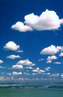
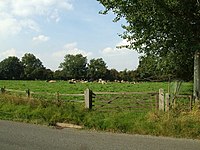
Weather is the state of the atmosphere, describing for example the degree to which it is hot or cold, wet or dry, calm or stormy, clear or cloudy. On Earth, most weather phenomena occur in the lowest layer of the planet's atmosphere, the troposphere, just below the stratosphere. Weather refers to day-to-day temperature, precipitation, and other atmospheric conditions, whereas climate is the term for the averaging of atmospheric conditions over longer periods of time. When used without qualification, "weather" is generally understood to mean the weather of Earth.

<span class="mw-page-title-main">Fog</span> Atmospheric phenomenon

Fog is a visible aerosol consisting of tiny water droplets or ice crystals suspended in the air at or near the Earth's surface. Fog can be considered a type of low-lying cloud usually resembling stratus, and is heavily influenced by nearby bodies of water, topography, and wind conditions. In turn, fog affects many human activities, such as shipping, travel, and warfare.

<span class="mw-page-title-main">Surface weather analysis</span> Type of weather map

Surface weather analysis is a special type of weather map that provides a view of weather elements over a geographical area at a specified time based on information from ground-based weather stations.

<span class="mw-page-title-main">Weather forecasting</span> Science and technology application

Weather forecasting is the application of science and technology to predict the conditions of the atmosphere for a given location and time. People have attempted to predict the weather informally for millennia and formally since the 19th century.

<span class="mw-page-title-main">Winter storm</span> Low-temperature extreme weather events of high winds and freezing precipitation forms

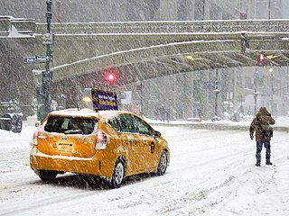
A winter storm is an event in which wind coincides with varieties of precipitation that only occur at freezing temperatures, such as snow, mixed snow and rain, or freezing rain. In temperate continental climates, these storms are not necessarily restricted to the winter season, but may occur in the late autumn and early spring as well. A snowstorm with strong winds and other conditions meeting certain criteria is called a blizzard.

<span class="mw-page-title-main">Synoptic scale meteorology</span> 1000-km-order method of measuring weather systems

In meteorology, the synoptic scale is a horizontal length scale of the order of 1,000 km (620 mi) or more. This corresponds to a horizontal scale typical of mid-latitude depressions. Most high- and low-pressure areas seen on weather maps are synoptic-scale systems, driven by the location of Rossby waves in their respective hemisphere. Low-pressure areas and their related frontal zones occur on the leading edge of a trough within the Rossby wave pattern, while high-pressure areas form on the back edge of the trough. Most precipitation areas occur near frontal zones. The word synoptic is derived from the Ancient Greek word συνοπτικός (sunoptikós), meaning "seen together".

<span class="mw-page-title-main">Warm front</span> Boundary of advancing mass of warm air

A warm front is a density discontinuity located at the leading edge of a homogeneous warm air mass, and is typically located on the equator-facing edge of an isotherm gradient. Warm fronts lie within broader troughs of low pressure than cold fronts, and move more slowly than the cold fronts which usually follow because cold air is denser and less easy to remove from the Earth's surface. This also forces temperature differences across warm fronts to be broader in scale. Clouds ahead of the warm front are mostly stratiform, and rainfall generally increases as the front approaches. Fog can also occur preceding a warm frontal passage. Clearing and warming is usually rapid after frontal passage. If the warm air mass is unstable, thunderstorms may be embedded among the stratiform clouds ahead of the front, and after frontal passage thundershowers may continue. On weather maps, the surface location of a warm front is marked with a red line of semicircles pointing in the direction of travel.

<span class="mw-page-title-main">June Gloom</span> Weather phenomenon where clouds develop and temperatures cool over coastal California

June Gloom is a California term for a weather pattern that results in cloudy, overcast skies with cool temperatures during the late spring and early summer. While it is most common in the month of June, it can occur in surrounding months, giving rise to other colloquialisms, such as “Graypril,” "May Gray," "No-Sky July," and "Fogust." Low-altitude stratus clouds form over the cool water of the California Current, and spread overnight into the coastal regions of California.

<span class="mw-page-title-main">Index of meteorology articles</span>

This is a list of meteorology topics. The terms relate to meteorology, the interdisciplinary scientific study of the atmosphere that focuses on weather processes and forecasting.

<span class="mw-page-title-main">Weather front</span> Boundary separating two masses of air of different densities

A weather front is a boundary separating air masses for which several characteristics differ, such as air density, wind, temperature, and humidity. Disturbed and unstable weather due to these differences often arises along the boundary. For instance, cold fronts can bring bands of thunderstorms and cumulonimbus precipitation or be preceded by squall lines, while warm fronts are usually preceded by stratiform precipitation and fog. In summer, subtler humidity gradients known as dry lines can trigger severe weather. Some fronts produce no precipitation and little cloudiness, although there is invariably a wind shift.

<span class="mw-page-title-main">San Francisco fog</span> Common weather phenomenon in San Francisco

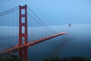
Fog is a common weather phenomenon in the San Francisco Bay Area as well as along the entire coastline of California extending south to the northwest coast of the Baja California Peninsula. The frequency of fog and low-lying stratus clouds is due to a combination of factors particular to the region that are especially prevalent in the summer. Another type of fog, tule fog, can occur during the winter. There are occasions when both types can occur simultaneously in the Bay Area. The prevalence of fog in the San Francisco Bay Area has decreased, and this trend is typically attributed to climate change.

The climate of Delhi is an overlap between monsoon-influenced humid subtropical and semi-arid, with high variation between summer and winter temperatures and precipitation. Delhi's version of a humid subtropical climate is markedly different from many other humid subtropical cities such as São Paulo, Houston, and Brisbane in that the city features dust storms and wildfire haze due to its semi-arid climate.

<span class="mw-page-title-main">Precipitation types</span> Characters, formations, and phases of water condensed in the atmosphere

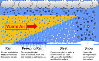
In meteorology, the different types of precipitation often include the character, formation, or phase of the precipitation which is falling to ground level. There are three distinct ways that precipitation can occur. Convective precipitation is generally more intense, and of shorter duration, than stratiform precipitation. Orographic precipitation occurs when moist air is forced upwards over rising terrain and condenses on the slope, such as a mountain.

<span class="mw-page-title-main">Western Disturbance</span> Extratropical storm over north India

A western disturbance is an extratropical storm originating in the Mediterranean region that brings sudden winter rain to the northwestern parts of the Indian subcontinent, which extends as east as up to northern parts of Bangladesh and South eastern Nepal. It is a non-monsoonal precipitation pattern driven by the westerlies. The moisture in these storms usually originates over the Mediterranean Sea, the Caspian Sea and the Black Sea. Extratropical storms are a global phenomena with moisture usually carried in the upper atmosphere, unlike their tropical counterparts where the moisture is carried in the lower atmosphere. In the case of the Indian subcontinent, moisture is sometimes shed as rain when the storm system encounters the Himalayas. Western disturbances are more frequent and stronger in the winter season.

<span class="mw-page-title-main">Cold front</span> Leading edge of a cooler mass of air

A cold front is the leading edge of a cooler mass of air at ground level that replaces a warmer mass of air and lies within a pronounced surface trough of low pressure. It often forms behind an extratropical cyclone, at the leading edge of its cold air advection pattern—known as the cyclone's dry "conveyor belt" flow. Temperature differences across the boundary can exceed 30 °C (54 °F) from one side to the other. When enough moisture is present, rain can occur along the boundary. If there is significant instability along the boundary, a narrow line of thunderstorms can form along the frontal zone. If instability is weak, a broad shield of rain can move in behind the front, and evaporative cooling of the rain can increase the temperature difference across the front. Cold fronts are stronger in the fall and spring transition seasons and are weakest during the summer.

<span class="mw-page-title-main">Groundhog Day</span> Popular North American tradition

Groundhog Day is a tradition observed in the United States and Canada on February 2 of every year starting in the 16th century. It derives from the Pennsylvania Dutch superstition that if a groundhog emerges from its burrow on this day and sees its shadow, it will retreat to its den and winter will go on for six more weeks; if it does not see its shadow, spring will arrive early.

<span class="mw-page-title-main">2013–14 North American winter</span>

The 2013–14 North American winter was one of the most significant for the United States, due in part to the breakdown of the polar vortex in November 2013, which allowed very cold air to travel down into the United States, leading to an extended period of very cold temperatures. The pattern continued mostly uninterrupted throughout the winter and numerous significant winter storms affected the Eastern United States, with the most notable one being a powerful winter storm that dumped ice and snow in the Southeastern United States and the Northeastern United States in mid-February. Most of the cold weather abated by the end of March, though a few winter storms did affect the Western United States towards the end of the winter.

<span class="mw-page-title-main">Glossary of meteorology</span> List of definitions of terms and concepts commonly used in meteorology

This glossary of meteorology is a list of terms and concepts relevant to meteorology and atmospheric science, their sub-disciplines, and related fields.

<span class="mw-page-title-main">Backdoor cold front</span>

A backdoor cold front, or backdoor front, is a cold front moving south or southwest along the northeast of the Atlantic seaboard in North America, particularly in the Northeastern United States and the Great Lakes. Typically occurring in spring, the front drives cool Atlantic air from the east or northeast into northeastern US that supersedes the warmer continental air. The front is termed "backdoor" because it arrives from the east, meaning it originates from the opposite direction of a typical cold front and therefore comes through the region's "back door."

References

  1. 1 2 Hazen, H. A. (July 1900). "The Origin and Value of Weather Lore". The Journal of American Folklore. 13 (50): 191–198. doi:10.2307/533883. JSTOR   533883.
  2. 1 2 3 Encyclopedia of climate and weather. Schneider, Stephen Henry., Root, Terry Louise., Mastrandrea, Michael D. (2nd ed.). New York: Oxford University Press. 2011. ISBN   978-0-19-531386-4. OCLC   714802771.{{cite book}}: CS1 maint: others (link)
  3. F.R.S, D. Brunt SC D. (1946-06-01). "Meteorology and Weather Lore". Folklore. 57 (2): 66–74. doi:10.1080/0015587X.1946.9717813. ISSN   0015-587X.
  4. Bergen, Fanny D.; Newell, W. W. (1889). "Weather-Lore". The Journal of American Folklore. 2 (6): 203–208. doi:10.2307/534149. ISSN   0021-8715. JSTOR   534149.
  5. Bridgewater, S. (January 1976). "Criteria for selection of nursing textbooks". The Journal of Nursing Education. 15 (1): 3–5. ISSN   0148-4834. PMID   1477.
  6. United States Department of Agriculture (retrieved 2006 November 27)
  7. 1 2 Sailnet.com (Retrieved 2006 April 24)
  8. WXSYS (retrieved 2007 February 15)
  9. Augustine, John; Smith, Lisa (September 2014). "The Red sky in morning sailor take warning". National Oceanic and Atmospheric Administration, Earth System Research Laboratory Global Monitoring Division.
  10. Corfidi, Stephen F. (September 2014). "The Colors of Sunset and Twilight". National Oceanic and Atmospheric Administration. (expanded from Weatherwise magazine, June/July 1996)
  11. "Red sky at night and other weather lore".
  12. Morehead Planetarium and Science Centre (Retrieved 2006 April 24)
  13. 1 2 3 Watts, Alan (1968). Instant Weather Forecasting in Canada . pp. 191–192. LCCN   68-9173.
  14. nsidc.colorado.edu (retrieved 2007 February 26)
  15. The Weather Network (retrieved 2007 February 15)
  16. Dotson, J. Dianne. "How Temperature & Humidity are Related". Sciencing.
  17. The Weather Doctor (Retrieved 2006 April 24)
  18. National Oceanic and Atmospheric Administration (January 29, 2002). "Climate-Watch, Special: Groundhog Day 2002". NOAA. Archived from the original on 2002-02-19. The table shows no predictive skill for the groundhog during the most recent years of this analysis
  19. Thomas, R. B. (1998), The Farmer's Almanac, p. 67, cited in Aaron et al. (2001), p. 28
  20. Allison, Christine (1995), 365 days of gardening, p. 353, cited in Aaron et al. (2001), p. 28
  21. 1 2 3 "Le jour de la marmotte, science ou folklore?". Radio-Canada. February 2, 2017. Retrieved December 26, 2015.
  22. Aaron, Michael A.; Boyd, Brewster B. Jr.; Curtis, Melanie J.; Sommers, Paul M. (January 2001), "Punxsutawney's Phenomenal Phorecaster", The College Mathematics Journal, 32 (1): 26–29, doi:10.1080/07468342.2001.11921847, JSTOR   2687216, S2CID   123766510 . doi:10.2307/2687216.
  23. 1 2 Diccionario de la lengua española (in Spanish) (23rd ed.). Real Academia Española. Retrieved 19 September 2019.
  24. "It's going to rain for 40 days..." The Connexion. 2 February 2017.
  25. "Wenn sich der Dachs zu Lichtmeß sonnt, so gehet er wieder auf vier Wochen in sein Loch." In: Lewenau, Joseph Arnold Ritter von (1823), Der angewandte Fresenius; oder, Sammlung geordneter allgemeiner Witterungs- und sogenannter Bauernregeln , Vienna, J.G. Mösle, p. 20.
  26. Adam, Lucien (1881). Les patois lorrains. Vol. 1. Maisonneuve. p. 386.
  27. Rodrigue, Denise (1983). Le cycle de Pâques au Québec et dans l'Ouest de la France. Presses Université Laval. pp. 34, 36. ISBN   9782763769035.
  28. "BBC - Religions - Christianity: Candlemas".
  29. Thomas Fuller (1732). Gnomologia. B. Barker.
  30. Punch v. 48. Tom Taylor. 1865.
  31. uwsp.edu Archived 2007-05-29 at the Wayback Machine (retrieved 2007 February 26)
  32. Tom Coghlan Last updated at 12:01AM, April 16, 2012. "The Times, Follow St Swithin: book a British break". Timesonline.co.uk. Retrieved 2012-04-16.{{cite news}}: CS1 maint: multiple names: authors list (link)
  33. Anders slaskar, julen braskar from SMHI (Swedish Meteorological and Hydrological Institute), accessed on 16 July 2015.
  34. wscsd.org Archived 2007-02-27 at the Wayback Machine (retrieved 2006 November 27)
  35. Quirinus von Rom (von Neuss) – Ökumenisches Heiligenlexikon
  36. Petstyle.com (retrieved 2007 February 15)
  37. About Onions: Quotes (retrieved 2006 November 27)
  38. "Weather wise - Everything2.com". everything2.com. Retrieved 2017-10-31.
  39. Alberta Agriculture (retrieved 2007 February 26)

Further reading