West Menlo Park, California

Last updated

West Menlo Park
San Mateo County California Incorporated and Unincorporated areas West Menlo Park Highlighted.svg
Location in San Mateo County and the state of California
Coordinates: 37°26′1″N122°12′11″W / 37.43361°N 122.20306°W / 37.43361; -122.20306
Country United States
State California
County San Mateo
Area
[1]
  Total0.486 sq mi (1.259 km2)
  Land0.486 sq mi (1.259 km2)
  Water0 sq mi (0 km2)  0%
Elevation
112 ft (34 m)
Population
 (2020)
  Total3,930
  Density8,100/sq mi (3,100/km2)
Time zone UTC-8 (PST)
  Summer (DST) UTC-7 (PDT)
ZIP code
94025
Area code 650
FIPS code 06-84536
GNIS feature ID1867071

West Menlo Park is a census-designated place and an Unincorporated community in San Mateo County, California, located between the majority of City of Menlo Park, the Town of Atherton, the Sharon Heights neighborhood of Menlo Park and Stanford University (in Santa Clara County). As of the 2020 census, the community had a population of 3,930.

Contents

The area consists of suburban housing and a small business district along Alameda de las Pulgas (literally, "Avenue of the Fleas"), often just referred to as "the Alameda", which extends the length of the Rancho de las Pulgas land granted to the Argüello family. West Menlo Park is served by the Las Lomitas School District and Menlo Park Fire District.

Geography

According to the United States Census Bureau, the CDP has a total area of 0.5 square miles (1.3 km2), all of it land. West Menlo Park has a mild climate.

Demographics

2010

The 2010 United States Census [2] reported that West Menlo Park had a population of 3,659. The population density was 7,526.9 inhabitants per square mile (2,906.2/km2). The racial makeup of West Menlo Park was 2,983 (81.5%) White, 28 (0.8%) African American, 2 (0.1%) Native American, 416 (11.4%) Asian, 4 (0.1%) Pacific Islander, 52 (1.4%) from other races, and 174 (4.8%) from two or more races. Hispanic or Latino of any race were 201 persons (5.5%).

The Census reported that 3,650 people (99.8% of the population) lived in households, 5 (0.1%) lived in non-institutionalized group quarters, and 4 (0.1%) were institutionalized.

There were 1,356 households, out of which 574 (42.3%) had children under the age of 18 living in them, 830 (61.2%) were opposite-sex married couples living together, 98 (7.2%) had a female householder with no husband present, 42 (3.1%) had a male householder with no wife present. There were 61 (4.5%) unmarried opposite-sex partnerships, and 11 (0.8%) same-sex married couples or partnerships. 292 households (21.5%) were made up of individuals, and 122 (9.0%) had someone living alone who was 65 years of age or older. The average household size was 2.69. There were 970 families (71.5% of all households); the average family size was 3.17.

The population was spread out, with 1,069 people (29.2%) under the age of 18, 101 people (2.8%) aged 18 to 24, 998 people (27.3%) aged 25 to 44, 1,004 people (27.4%) aged 45 to 64, and 487 people (13.3%) who were 65 years of age or older. The median age was 40.4 years. For every 100 females, there were 95.7 males. For every 100 females age 18 and over, there were 91.1 males.

There were 1,422 housing units at an average density of 2,925.2 per square mile (1,129.4/km2), of which 1,091 (80.5%) were owner-occupied, and 265 (19.5%) were occupied by renters. The homeowner vacancy rate was 0.9%; the rental vacancy rate was 5.3%. 2,999 people (82.0% of the population) lived in owner-occupied housing units and 651 people (17.8%) lived in rental housing units.

2000

As of the census [3] of 2000, there were 3,629 people, 1,420 households, and 955 families residing in the CDP. The population density was 7,299.8 inhabitants per square mile (2,818.5/km2). There were 1,451 housing units at an average density of 2,918.7 per square mile (1,126.9/km2). The racial makeup of the CDP in 2010 was 77.6% non-Hispanic White, 0.7% non-Hispanic African American, 0.1% Native American, 11.4% Asian, 0.1% Pacific Islander, 0.3% from other races, and 4.3% from two or more races. Hispanic or Latino of any race were 5.5% of the population. There were 1,420 households, out of which 34.7% had children under the age of 18 living with them, 57.6% were married couples living together, 7.0% had a female householder with no husband present, and 32.7% were non-families. 25.0% of all households were made up of individuals, and 8.7% had someone living alone who was 65 years of age or older. The average household size was 2.55 and the average family size was 3.04.

In the CDP, the population was spread out, with 25.3% under the age of 18, 3.6% from 18 to 24, 32.1% from 25 to 44, 25.8% from 45 to 64, and 13.3% who were 65 years of age or older. The median age was 39 years. For every 100 females, there were 96.0 males. For every 100 females age 18 and over, there were 91.1 males.

The median income for a household in the CDP was $125,881, and the median income for a family was $145,946. Males had a median income of $100,000+ versus $70,486 for females. The per capita income for the CDP was $62,302. 2.9% of the population and 0.4% of families were below the poverty line. 0.3% of those under the age of 18 and 4.1% of those 65 and older were living below the poverty line.

Politics

In the California State Legislature, West Menlo Park is in the 13th Senate District , represented by Democrat Josh Becker, and in the 24th Assembly District , represented by Democrat Alex Lee. [4]

In the United States House of Representatives, West Menlo Park is in California's 16th congressional district , represented by Democrat Anna Eshoo per the 2020 redistricting cycle.

Education

For primary schools, West Menlo Park is served by the Las Lomitas Elementary School District. For high school, West Menlo Park is served by the Sequoia Union High School District, with all of West Menlo Park falling into the boundaries of Menlo-Atherton High School.

Related Research Articles

<span class="mw-page-title-main">West Bishop, California</span> Census-designated place in California, United States

West Bishop is a census-designated place (CDP) in Inyo County, California, United States. The population was 2,607 at the 2010 census, down from 2,807 at the 2000 census.

<span class="mw-page-title-main">Alondra Park, California</span> Census designated place in California, United States

Alondra Park, also known as El Camino Village, is a census designated place (CDP) in Los Angeles County, California, United States. It is the unincorporated area north of Alondra Community Regional Park and El Camino College. It is east of Lawndale, south of Hawthorne, west of Gardena, and north of Torrance. Manhattan Beach Boulevard and Crenshaw Boulevard are the two major cross streets in the area. The population was 8,569 at the 2020 census, down from 8,592 at the 2010 census. There is an official Alondra Park Post Office of the U.S. Postal Service in nearby Gardena, California. Urbanized cement-lined Dominguez Creek bisects a portion of Alondra Park.

<span class="mw-page-title-main">South San Gabriel, California</span> Census-designated place in California, United States

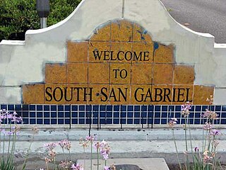
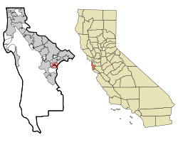
South San Gabriel is a census-designated place (CDP) in Los Angeles County, California, United States. The population was 8,070 at the 2010 census, up from 7,595 at the 2000 census.

<span class="mw-page-title-main">West Athens, California</span> Unincorporated community in California, United States

West Athens is a census-designated place (CDP) in Los Angeles County, California. The population was 9,393 at the 2020 census. It is an unincorporated community within the 2nd Supervisorial District of Los Angeles County. West Athens is served by the Los Angeles County Sheriff's Department, operating out of the South Los Angeles Station. The approximate boundaries for West Athens are: 87th Street to the north, Vermont Avenue to the east, El Segundo Boulevard to the south, and approximately Western Avenue to Van Ness Avenue to the west. West Athens is predominantly residential, with commercial uses along its main corridors. Los Angeles Southwest Community College lies within the West Athens neighborhood and city limits.

<span class="mw-page-title-main">West Rancho Dominguez, California</span> Unincorporated community in California, United States

West Rancho Dominguez, formerly known as West Compton, is an unincorporated census-designated place (CDP) located in southern Los Angeles County, California. Per the 2020 census, the population was 24,347. The community lies to the west of the city of Compton. The ZIP Codes encompassing the CDP area are 90220 & 90248.

<span class="mw-page-title-main">West Puente Valley, California</span> Census-designated place in California, United States

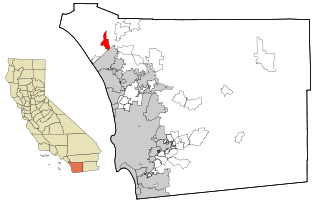
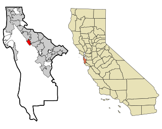
West Puente Valley is an unincorporated community and census-designated place in Los Angeles County, California, USA, northwest of La Puente. The population was 22,636 at the 2010 census, up from 22,589 at the 2000 census. The community is probably named for its location related to the city of La Puente.

<span class="mw-page-title-main">Lagunitas-Forest Knolls, California</span> Census-designated place in California, United States

Lagunitas-Forest Knolls is a census-designated place, composed of two unincorporated areas in the western half of the San Geronimo Valley in Marin County, California. It is located to the west of San Geronimo and Woodacre. The population was 1,924 at the 2020 census.

<span class="mw-page-title-main">San Geronimo, California</span> Census-designated place in California, United States

San Geronimo is a census-designated place (CDP) located in the San Geronimo Valley in Marin County, California in the United States. San Geronimo is bordered by Lagunitas-Forest Knolls to its west and Woodacre to its east. It is 8 miles (13 km) southwest of downtown Novato at an elevation of 292 feet (89 m). The population was 510 at the 2020 census.

<span class="mw-page-title-main">Tamalpais-Homestead Valley, California</span> Census-designated place in California, United States

Tamalpais-Homestead Valley is a census-designated place (CDP) in Marin County, California, United States. The population was 11,492 at the 2020 census.

<span class="mw-page-title-main">Lake Almanor West, California</span> Census-designated place in California, United States

Lake Almanor West is a census-designated place (CDP) in Plumas County, California, United States. The population was 270 at the 2010 census, down from 329 at the 2000 census.

<span class="mw-page-title-main">Big River, California</span> Census-designated place in California, United States

Big River is a census-designated place (CDP) in San Bernardino County, California, United States. The population was 1,327 at the 2010 census, up from 1,266 at the 2000 census.

<span class="mw-page-title-main">Camp Pendleton Mainside, California</span> Census-designated place in California, United States

Camp Pendleton Mainside is a census-designated place (CDP) in San Diego County, California, located at the southeast corner of the Marine Corps Base Camp Pendleton. Per the 2020 census, the population was 9,683. It was formerly known as Camp Pendleton North, but its name was changed for the 2020 Census. Along with Camp Pendleton South, it is one of two CDPs located on the base.

<span class="mw-page-title-main">Highlands-Baywood Park, California</span> Unincorporated community in California, United States

Highlands-Baywood Park is an unincorporated community in San Mateo County, California, United States. The population was 4,027 at the 2010 census.

<span class="mw-page-title-main">Lexington Hills, California</span> Census-designated place in California, United States

Lexington Hills is a census-designated place and an unincorporated area in Santa Clara County, California, United States. The population was 2,492 at the 2020 census. The area is located in the Santa Cruz Mountains, about five miles south of Los Gatos and about 14 miles (23 km) north of Santa Cruz. Lexington Hills is the name assigned by the United States Census Bureau to the area, which actually comprises several small communities, including Redwood Estates, Holy City, Chemeketa Park, and Aldercroft Heights.

<span class="mw-page-title-main">Riverdale Park, California</span> Census-designated place in California, United States

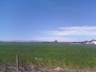
Riverdale Park is a census-designated place (CDP) in Stanislaus County, California, United States. The population was 1,128 at the 2010 census, up from 1,094 at the 2000 census. It is part of the Modesto Metropolitan Statistical Area.

<span class="mw-page-title-main">West Modesto, California</span> Census-designated place in California, United States

West Modesto is a census-designated place (CDP) in Stanislaus County, California, United States. The population was 5,682 at the 2010 census, down from 6,096 at the 2000 census. It is part of the Modesto Metropolitan Statistical Area.

<span class="mw-page-title-main">Jamestown, California</span> Census-designated place in California, United States

Jamestown is a census-designated place (CDP) in Tuolumne County, California, United States. The population was 3,433 at the 2010 census, up from 3,017 at the 2000 census. Formerly a California Gold Rush town, Jamestown is a California Historical Landmark since March 16, 1949. It is the home of Railtown 1897 State Historic Park and the Sierra Railway, which operates steam passenger trains.

Grandwood Park is a census-designated place (CDP) in Warren Township, Lake County, Illinois, United States. Per the 2020 census, the population was 5,297.

<span class="mw-page-title-main">Menlo, Iowa</span> City in Iowa, United States

Menlo is a city in Guthrie County, Iowa, United States. The population was 345 at the time of the 2020 census. It is part of the Des Moines–West Des Moines Metropolitan Statistical Area.

<span class="mw-page-title-main">Garden City Park, New York</span> Hamlet and census-designated place in New York, United States

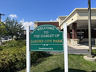
Garden City Park is a hamlet and census-designated place (CDP) located in the Town of North Hempstead in Nassau County, on Long Island, in New York, United States. The population was 7,806 at the 2010 census.

References

  1. U.S. Census
  2. "2010 Census Interactive Population Search: CA - West Menlo Park CDP". U.S. Census Bureau. Archived from the original on July 15, 2014. Retrieved July 12, 2014.
  3. "U.S. Census website". United States Census Bureau . Retrieved January 31, 2008.
  4. "Statewide Database". UC Regents. Retrieved January 7, 2015.