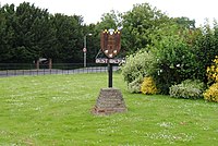
Blakeney is a coastal village and civil parish in the English county of Norfolk. Blakeney lies within the Norfolk Coast AONB and the North Norfolk Heritage Coast. The North Norfolk Coastal Path travels along its quayside. The village is 21.1 mi (34 km) north west of Norwich, 4.6 mi (7.4 km) NNW of the larger settlement of Holt, 11.5 mi (18.5 km) west of Cromer and 112 mi (180 km) NNE of London.

Anmer is a small village and civil parish in the English county of Norfolk. It is around 12 miles (19 km) north-east of the town of King's Lynn and 35 miles (56 km) north-west of the city of Norwich. The parish is in the district of King's Lynn and West Norfolk and at the 2001 census had a population of 63 in 29 households.

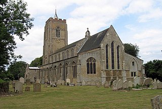
Antingham is a village and civil parish in the north of the English county of Norfolk. The village is located about 6 miles (9.7 km) south of Cromer and 3 miles (4.8 km) north of North Walsham. The civil parish has an area of 6.12 square kilometres and in the 2001 census had a population of 287 in 120 households, the population increasing to 355 at the 2011 Census. For the purposes of local government, the parish falls within the district of North Norfolk.
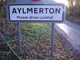
Aylmerton is a village in the county of Norfolk, England. It is in the area of North Norfolk and lies 2.2 miles (3.5 km) south of the North Sea, 3.2 miles (5.1 km) south-west of Cromer and 7.5 miles (12.1 km) east of Holt. The parish is bordered by the parishes of Beeston Regis and Runton to the north, West Beckham to the west, Felbrigg to the east and Gresham and Sustead to the south. The centre of the village is ¾ miles south of the A148 King’s Lynn to Cromer road with Sandy Lane and Beechwood Avenue north of it. The nearest railway stations are West Runton at the bottom of Sandy Lane, Cromer at 2.9 miles (4.7 km) and Roughton Road at 4.1 miles (6.6 km). The civil parish has an area of 6.86 square kilometres and in the 2001 census the population was 435 in 178 households, increasing to 458 at the 2011 Census. For the purposes of local government, the parish is in North Norfolk, whose headquarters are in Cromer.

Barton Bendish is a civil parish and small ancient village in the English county of Norfolk. It has two medieval parish churches, and once had three. The parish includes the old hamlet of Eastmoor, and covers 3936 acres.
Wimbotsham is a village and civil parish in the English county of Norfolk. It is situated close to the River Great Ouse, 2 km (1.2 mi) north of the town of Downham Market, 18 km (11 mi) south of the town of King's Lynn, and 60 km (37 mi) west of the city of Norwich. It covers an area of 6.04 km2 (2.33 sq mi) and had a population of 558 in 262 households at the 2001 census, the population including Bexwell and increasing to 664 at the 2011 Census. For the purposes of local government, it falls within the district of King's Lynn and West Norfolk.

North Runcton is a village and a civil parish in the English county of Norfolk. The village is 43.2 miles (69.5 km) west of Norwich, 4.3 miles (6.9 km) south-south-west of King's Lynn and 102 miles (164 km) north of London. The village is located a small distance south-west of the A47 between King's Lynn and Swaffham. The nearest railway station is at King's Lynn for the Fen Line which runs between King's Lynn and Cambridge. The nearest airport is Norwich International Airport. The parish of North Runcton in the 2001 census, has a population of 266, increasing to 549 at the 2011 Census. For the purposes of local government, the parish falls within the district of King's Lynn and West Norfolk.

Gunthorpe is a village and a civil parish in the English county of Norfolk. The village is 8.6 miles east north east of the town of Fakenham, 14.9 miles west south west of Cromer and 122 miles north north east of London. The nearest railway station is at Sheringham for the Bittern Line which runs between Sheringham, Cromer and Norwich. The nearest airport is Norwich International Airport.
Stody is a village and a civil parish in the English county of Norfolk. The village is 13.2 miles (21.2 km) west south west of Cromer, 21.8 miles (35.1 km) north north west of Norwich and 125 miles (201 km) north north east of London. The village lies 4.1 miles (6.6 km) south west of the town of Holt. The nearest railway station is at Sheringham for the Bittern Line which runs between Sheringham, Cromer and Norwich. The nearest airport is Norwich International Airport.

Knapton is a village and a civil parish in the English county of Norfolk. The village is 8.9 miles (14.3 km) southeast of Cromer, 19.4 miles (31.2 km) northeast of Norwich and 134 miles (216 km) northeast of London. The Village is located alongside the B1145 a route which runs between King's Lynn and Mundesley. The nearest railway station is at North Walsham for the Bittern Line which runs between Sheringham, Cromer and Norwich. The nearest airport is Norwich International Airport.

Babingley is a hamlet and abandoned village in Norfolk, England, about 1 mile (1.6 km) northwest of Castle Rising and 5+1⁄2 miles (9 km) north-north-east of King's Lynn.

Swafield is a village and a civil parish in the English county of Norfolk. The village is 16.4 miles (26.4 km) north north east of Norwich, 10.1 miles (16.3 km) south south east of Cromer and 133 miles (214 km) north-east of London. The village lies 1.4 miles (2.3 km) north of the town of North Walsham. The village sits astride the B1145 Kings Lynn to Mundesley road that bisects North Norfolk west to east. The nearest railway station is at North Walsham for the Bittern Line which runs between Sheringham and Norwich. The nearest airport is Norwich International Airport. The parish had in 2001 census, a population of 273, including Bradfield and increasing to 315 at the 2011 Census. For the purposes of local government, the parish falls within the district of North Norfolk.

Little Ellingham is a village and civil parish in the English county of Norfolk. The village is 4.6 miles (7.4 km) north-west of Attleborough, 2 miles (3.2 km) north-west of its sister village of Great Ellingham, 18.8 miles (30.3 km) west-south-west of Norwich and 105 miles (169 km) north-east of London. The nearest railway station is at Attleborough for the Breckland Line which runs between Cambridge and Norwich. The nearest airport is Norwich International Airport.
Outwell is a village and civil parish in the borough of King's Lynn and West Norfolk, in the English county of Norfolk.
Emneth is a village and a civil parish in the English county of Norfolk. The village is 58 miles (93 km) west of Norwich, 15.4 miles (24.8 km) south-west of King's Lynn and 99.6 miles (160.3 km) north of London. The nearest town is Wisbech which is 3.3 miles (5.3 km) north-north-west of the village. The village lies to the south-west of the route of the A47 between Peterborough and King's Lynn. Since 1968, the nearest railway station is over 7 miles east, at Downham Market for the Fen Line which runs between King's Lynn and Cambridge. The nearest airport is Cambridge International Airport. The parish of Emneth in the 2001 census, has a population of 2,466, increasing to 2,617 at the 2011 Census. For the purposes of local government, the parish falls within the district of King's Lynn and West Norfolk.

Tilney St Lawrence is a village and a civil parish in the English county of Norfolk The village is 52.3 miles (84.2 km) west of Norwich, 9.7 miles (15.6 km) south-south-west of King's Lynn and 104 miles (167 km) north of London. The nearest town is Wisbech which is 8.3 miles (13.4 km) west-south-west of the village. The village lies to the south of the route of the A47 between Peterborough and Kings Lynn. The parish of Tilney St Lawrence in the 2001 census had a population of 1,465, increasing to 1,576 at the 2011 Census. For the purposes of local government, the parish falls within the district of King's Lynn and West Norfolk.

Walsoken is a settlement and civil parish in Norfolk, England, which is conjoined as a suburb at the northeast of the town of Wisbech, Isle of Ely, Cambridgeshire.

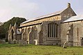
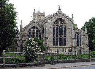
St Mary's Church is a ruined redundant Anglican church in the civil parish of Tilney St Lawrence, Norfolk, England. It is recorded in the National Heritage List for England as a designated Grade II* listed building, and is under the care of the Churches Conservation Trust. The ruins stand in an isolated position adjacent to Islington Hall Farm, immediately to the south of the A47 road between King's Lynn and Wisbech.

St John the Baptist's Church is a redundant Anglican church in the village of Parson Drove, Cambridgeshire, England. It is recorded in the National Heritage List for England as a designated Grade II* listed building, and is under the care of the Churches Conservation Trust. The church stands at the east end of the village, on the north side of the B1169 road, some 6 miles (10 km) west of Wisbech.

St Mary's Church is in Walton, Liverpool, Merseyside, England. It is an active Anglican parish church in the deanery of Walton, the archdeaconry of Liverpool and the diocese of Liverpool. Its benefice is united with those of St Nathanael, Walton-on-the-Hill, and St Aidan, Walton-on-the-Hill, to form the Walton Team Ministry. The church is recorded in the National Heritage List for England as a designated Grade II listed building.