Breckland District

Last updated
Breckland District
Dereham market place.JPG
Dereham, the administrative centre of the district and the second-largest settlement in the district
Breckland UK locator map.svg
Breckland shown within Norfolk
Sovereign state Flag of the United Kingdom.svg  United Kingdom
Constituent country Flag of England.svg  England
Region East of England
Non-metropolitan county Norfolk
Status Non-metropolitan district
Admin HQ Dereham
Incorporated1 April 1974
Government
  TypeNon-metropolitan district council
  BodyBreckland District Council
   MPs George Freeman
Liz Truss
Area
  Total1,035.1 km2 (399.7 sq mi)
  Rank17th (of 296)
Population
 (2021)
  Total142,164
  Rank158th (of 296)
  Density140/km2 (360/sq mi)
Ethnicity (2021)
[1]
   Ethnic groups
List
Religion (2021)
[1]
   Religion
List
Time zone UTC0 (GMT)
  Summer (DST) UTC+1 (BST)
ONS code 33UB (ONS)
E07000143 (GSS)
OS grid reference TG018081

Breckland is a local government district in Norfolk, England. Its council is based in Dereham, although the largest town is Thetford. The district also includes the towns of Attleborough, Swaffham and Watton, along with numerous villages and surrounding rural areas.

Contents

The district derives its name from the Breckland landscape region, a gorse-covered sandy heath of south Norfolk and north Suffolk. The term "Breckland" dates back to at least the 13th century.

The neighbouring districts are King's Lynn and West Norfolk, North Norfolk, Broadland, South Norfolk, Mid Suffolk and West Suffolk.

History

The district was created on 1 April 1974 under the Local Government Act 1972, covering six former districts which were all abolished at the same time: [2]

The new district was named Breckland after the distinctive landscape which covers parts of the area. [3] The name was chosen following a competition organised by the outgoing authorities which invited local schools, organisations and individuals to put forward suggested names. [4]

Governance

Breckland Council
Breckland Council logo.svg
Type
Type
Leadership
Peter Wilkinson,
Conservative
since 18 May 2023 [5]
Sam Chapman-Allen,
Conservative
since 16 May 2019
Maxine O'Mahony
since 2021 [6]
Structure
Seats49 councillors
Political groups
Administration (30)
  Conservative (30)
Other parties (19)
  Labour (12)
  Independent (5)
  Green (1)
  Liberal Democrats (1)
Elections
Last election
4 May 2023
Next election
6 May 2027
Meeting place
Elizabeth House, Walpole Loke, Dereham, NR19 1EE
Website
www.breckland.gov.uk
Thetford is the largest settlement in the district Cmglee Thetford market.jpg
Thetford is the largest settlement in the district

Breckland District Council, which styles itself "Breckland Council", provides district-level services. County-level services are provided by Norfolk County Council. The whole district is also covered by civil parishes, which form a third tier of local government. [7] [8]

Political control

The council has been under Conservative majority control since 1999.

The first election to the council was held in 1973, initially operating as a shadow authority alongside the outgoing authorities until the new arrangements took effect on 1 April 1974. Political control of the council since 1974 has been as follows: [9]

Party in controlYears
No overall control 1974–1979
Conservative 1979–1995
No overall control 1995–1999
Conservative 1999–present

Leadership

The leaders of the council since 1998 have been: [10]

CouncillorPartyFromTo
Cliff Jordan [11] Conservative 19982005
William Nunn [12] Conservative 20055 Sep 2013
Michael Wassell [13] [14] Conservative 11 Sep 201331 Mar 2016
William Nunn [15] [16] Conservative 31 Mar 201616 May 2019
Sam Chapman-Allen Conservative 16 May 2019

Composition

Following the 2023 election the composition of the council was: [17]

PartyCouncillors
Conservative 30
Labour 12
Independent 5
Liberal Democrats 1
Green 1
Total49

The next election is due in 2027.

Attleborough, the third-largest settlement in the district St Mary's church Attleborough - geograph.org.uk - 3269362.jpg
Attleborough, the third-largest settlement in the district
Swaffham, the fourth-largest settlement in the district The buttercross at Swaffham Market Place - geograph.org.uk - 2108169.jpg
Swaffham, the fourth-largest settlement in the district

Elections

Since the last boundary changes in 2015 the council has comprised 49 councillors representing 27 wards, with each ward electing one, two or three councillors. Elections are held every four years. [18]

UK Youth Parliament

Although the UK Youth Parliament is an apolitical organisation, the elections are run in a way similar to that of the Local Elections. The votes come from 11 to 18 year olds and are combined to make the decision of the next, 2 year Member of Youth Parliament. The elections are run at different times across the country with Breckland's typically being in early Spring and bi-annually. [19] [20] [21]

Watton, the fifth-largest settlement in the district St. Mary, the parish church of Watton - geograph.org.uk - 2967395.jpg
Watton, the fifth-largest settlement in the district

Premises

The council has its headquarters at Elizabeth House, a modern office building on the edge of Dereham; the council moved its main offices there in 2003. [22] Prior to that it had been based at the Guildhall on St Withburga Lane in Dereham, which had previously been the offices of Mitford and Launditch Rural District Council, one of the council's predecessors. [23] [24]

Breckland House, St Nicholas Street, Thetford: Council's area office in Thetford, built 1992. Minstergate, Thetford - geograph.org.uk - 4726382.jpg
Breckland House, St Nicholas Street, Thetford: Council's area office in Thetford, built 1992.

The council also maintains an area office at Breckland House on St Nicholas Street in Thetford, which was completed in 1992 and formally opened on 20 May 1993 by Elizabeth II. [25] [26]

Towns and parishes

The district is entirely divided into 113 civil parishes. The parish councils for Attleborough, Dereham, Swaffham, Thetford and Watton have declared their parishes to be towns, allowing them to take the style "town council". Some of the smaller parishes have a parish meeting rather than a parish council. The parishes are: [27]

Related Research Articles

<span class="mw-page-title-main">Swaffham</span> Town in Norfolk, England

Swaffham is a market town and civil parish in the Breckland District and English county of Norfolk. It is situated 12 miles east of King's Lynn and 31 miles west of Norwich.

<span class="mw-page-title-main">King's Lynn and West Norfolk</span> Borough and non-metropolitan district in England

King's Lynn and West Norfolk is a local government district with borough status in Norfolk, England. Its council is based in the town of King's Lynn. The district also includes the towns of Downham Market and Hunstanton, along with numerous villages and surrounding rural areas. The population of the district at the 2021 census was 154,325.

<span class="mw-page-title-main">Attleborough</span> Human settlement in England

Attleborough is a market town and civil parish located on the A11 between Norwich and Thetford in Norfolk, England. The parish is in the district of Breckland and has an area of 21.9 square kilometres (8.5 sq mi).

<span class="mw-page-title-main">South West Norfolk (UK Parliament constituency)</span> Parliamentary constituency in the United Kingdom, 1885 onwards

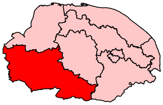
South West Norfolk is a constituency represented in the House of Commons of the UK Parliament since 2010 by Liz Truss of the Conservative Party, who briefly served as Prime Minister of the United Kingdom from September to October 2022.

<span class="mw-page-title-main">Mid Norfolk (UK Parliament constituency)</span> Parliamentary constituency in the United Kingdom, 1885-1918 & 1983 onwards

Mid Norfolk is a constituency represented in the House of Commons of the UK Parliament since 2010 by George Freeman, a Conservative.

<span class="mw-page-title-main">Watton, Norfolk</span> Human settlement in England

derham is a market town in the district of Breckland in the English county of Norfolk, about 25 miles (40 km) west-southwest of Norwich and 15 miles (24 km) northeast of Thetford. The annual Wayland Agricultural Show in its west is one of the oldest one-day such shows in England.

<span class="mw-page-title-main">Bawdeswell</span> Small rural village and civil parish in Norfolk, England

Bawdeswell is a small rural village and civil parish in Norfolk, England. At the time of the 2011 census it had a population of 828 and an area of 487 hectares. The village is situated almost in the centre of Norfolk about 14 miles (23 km) northwest of Norwich. For the purposes of local government it falls within the Upper Wensum Ward of Breckland District Council and the Elmham and Mattishall Division of Norfolk County Council. It is on a Roman road that ran east–west between Durobrivae near modern Peterborough and Smallburgh, crossing the Fen Causeway.

<span class="mw-page-title-main">Litcham</span> Human settlement in England

Litcham is a village and civil parish in the English county of Norfolk. It is situated some 10 km (6.2 mi) north-east of the town of Swaffham and 40 km (25 mi) west of the city of Norwich. The village is located on the B1145 a route which runs between King's Lynn and Mundesley.

Norfolk County Council in England is elected every four years. Since the last boundary changes in 2005, 84 councillors have been elected from 84 wards.

<span class="mw-page-title-main">North Pickenham</span> Human settlement in England

North Pickenham is a village in the Breckland district of mid-Norfolk, East Anglia, England. It lies three miles from the Georgian market town of Swaffham.

<span class="mw-page-title-main">Little Cressingham</span> Human settlement in England

Little Cressingham lies 2.5 miles (4.0 km) south east by road from Great Cressingham, 3 miles (4.8 km) west of Watton and 8 miles (13 km) south of Swaffham in the Breckland District of Norfolk. It covers an area of 11.90 km2 (4.59 sq mi) and had a population of 157 in 70 households at the 2001 census It is in the civil parish of Great Cressingham. The village is located on the edge of the Stanford Battle Area.

<span class="mw-page-title-main">East Tuddenham</span> Human settlement in England

East Tuddenham is a village in the English county of Norfolk. The village is located 5.6 miles (9.0 km) south-west of Dereham and 9.5 miles (15.3 km) north-west of Norwich and is bisected by the A47 between Birmingham and Lowestoft.

<span class="mw-page-title-main">2009 Norfolk County Council election</span>

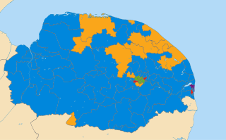
The Norfolk County Council election took place on 4 June 2009, coinciding with local elections for all county councils in England.

<span class="mw-page-title-main">Bury and Thetford (Swaffham Branch)</span>

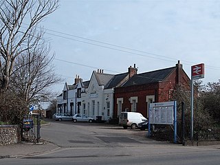
The Bury and Thetford, also known as the Crab and Winkle Line, was a railway line in England. It was formed of the Watton and Swaffham Railway, founded in 1866 as an independent venture by the Thetford and Watton Railway Company. Freight services commenced in January 1869, with passenger services in October 1869. The line ran from Thetford, via Watton to a junction with the Lynn and Dereham Railway at Swaffham and was completed in 1875. The extension to Swaffham cost £72,000,

<span class="mw-page-title-main">2019 Breckland District Council election</span>

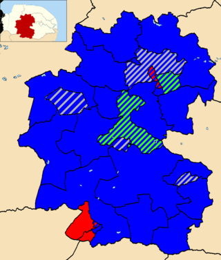
The 2019 Breckland District Council election took place on 2 May 2019 to elect members of Breckland District Council in England. This was on the same day as other local elections. The boundaries for this election were the same as those used in 2015.

<span class="mw-page-title-main">2023 Breckland District Council election</span>

The 2023 Breckland District Council election took place on 4 May 2023 to elect members of Breckland District Council in England. This was on the same day as other local elections. The boundaries for this election were the same as those used in 2015 and 2019.

References

  1. 1 2 UK Census (2021). "2021 Census Area Profile – Breckland Local Authority (E07000143)". Nomis. Office for National Statistics . Retrieved 5 January 2024.
  2. "The English Non-metropolitan District (Definition) Order 1972", legislation.gov.uk , The National Archives, SI 1972/2039, retrieved 17 November 2023
  3. "The English Non-metropolitan Districts (Names) Order 1973", legislation.gov.uk , The National Archives, SI 1973/551, retrieved 31 May 2023
  4. "Breckland may be name of new council". Lynn Advertiser. 8 December 1972. p. 8. Retrieved 3 December 2023.
  5. "Council minutes, 18 May 2023". Breckland Council. Retrieved 4 December 2023.
  6. Webb, Allister (14 October 2021). "Breckland Council confirms new chief executive". Lynn News. Retrieved 4 December 2023.
  7. "Local Government Act 1972", legislation.gov.uk , The National Archives, 1972 c. 70, retrieved 31 May 2023
  8. "Election Maps". Ordnance Survey. Retrieved 21 September 2023.
  9. "Compositions calculator". The Elections Centre. 4 March 2016. Retrieved 1 June 2023.
  10. "Council minutes". Breckland District Council. Retrieved 24 June 2022.
  11. Hannant, David (18 May 2018). "Norfolk County Council leader Cliff Jordan resigns following lung cancer diagnosis". Eastern Daily Press. Retrieved 24 June 2022.
  12. "Breckland Council leader William Nunn to resign". BBC News. 20 August 2013. Retrieved 24 June 2022.
  13. McMahon, Rosa (12 September 2013). "Breckland Council's new leader and deputy vow to innovate". Eastern Daily Press. Retrieved 24 June 2022.
  14. Lazzari, Adam (11 March 2016). "Breckland Council leader stands down for 'personal and private reaons'". Eastern Daily Press. Retrieved 24 June 2022.
  15. Ward, Zach (1 April 2016). "Breckland Council has confirmed previous leader William Nunn has retaken the role". Diss Express. Retrieved 24 June 2022.
  16. Parkin, Simon (4 May 2019). "Breckland council leader stands down day after local elections". Eastern Daily Press. Retrieved 24 June 2022.
  17. "Local elections 2023: live council results for England". The Guardian.
  18. "The Breckland (Electoral Changes) Order 2014", legislation.gov.uk , The National Archives, SI 2014/3290, retrieved 4 December 2023
  19. "Members of Youth Parliament - Norfolk County Council". www.norfolk.gov.uk.
  20. "Your Norfolk -". yournorfolk.norfolkpublications.org.uk.
  21. Cope, Lauren (30 March 2018). "Norfolk's four new Members of Youth Parliament are announced". Eastern Daily Press.
  22. "Welcome to Breckland". Breckland Council. Archived from the original on 18 June 2003. Retrieved 4 December 2023.
  23. "No. 34648". The London Gazette (Supplement). 25 July 1939. p. 5122.
  24. "New twist to Guildhall saga". Dereham Times. 9 January 2008. Retrieved 4 December 2023.
  25. "A Royal Splash". Bury Free Press. 21 May 1993. p. 1. Retrieved 4 December 2023.
  26. "Visit us". Breckland Council. Retrieved 4 December 2023.
  27. "Town and parish councils". Breckland Council. Retrieved 4 December 2023.

52°38′N0°59′E / 52.633°N 0.983°E / 52.633; 0.983