Uttlesford

Last updated

Uttlesford District
St Mary the Virgin, Saffron Walden - geograph.org.uk - 3494445.jpg
Saffron Walden, the administrative centre of the district
Uttlesford UK locator map.svg
Uttlesford shown within Essex
Sovereign state United Kingdom
Constituent country England
Region East of England
Non-metropolitan county Essex
Status Non-metropolitan district
Admin HQ Saffron Walden
Incorporated1 April 1974
Government
  TypeNon-metropolitan district council
  BodyUttlesford District Council
  LeadershipAlternative - Sec. 31 (Conservative)
   MPs Kemi Badenoch
Area
  Total247.56 sq mi (641.18 km2)
  Rank54th (of 296)
Population
 (2022)
  Total92,578
  Rank259th (of 296)
  Density370/sq mi (140/km2)
Ethnicity (2021)
[1]
   Ethnic groups
List
Religion (2021)
[1]
   Religion
List
Time zone UTC0 (GMT)
  Summer (DST) UTC+1 (BST)
ONS code 22UQ (ONS)
E07000077 (GSS)
OS grid reference TL541387

Uttlesford is a local government district in Essex, England. Its council is based in the town of Saffron Walden. The district also includes the town of Great Dunmow and numerous villages, including Stansted Mountfitchet, Takeley, Elsenham, Thaxted, and Newport. The district covers a largely rural area in the north-west of Essex. London Stansted Airport lies within the district.

Contents

The neighbouring districts are Braintree, Chelmsford, Epping Forest, East Hertfordshire, North Hertfordshire and South Cambridgeshire.

History

The district was formed on 1 April 1974 under the Local Government Act 1972 as one of 14 districts within Essex. The new district covered the area of three former districts, which were all abolished at the same time: [2]

The new district was named after the ancient hundred of Uttlesford, which had covered much of the area. [3]

The hundred had been named after a ford on the London Road (now the B1383, formerly the A11) at Wendens Ambo, since replaced by a bridge. The ford appears to derive its name from "Udel's ford". The stream at the ford is sometimes informally called the River Uttle as a back-formation from the name of the ford. [4] [5] [6]

Hundreds gradually lost their functions to other bodies from the seventeenth century onwards, with their final administrative function ceasing in 1886. The name Uttlesford continued to have occasional use in the area between then and 1974, such as the Uttlesford Orchestra, founded in 1956, which played in and around Saffron Walden. [7]

Governance

Uttlesford District Council
Uttlesford District Council logo.png
Type
Type
History
Founded1 April 1974
Leadership
Geof Driscoll,
R4U
since 23 May 2023
Petrina Lees,
R4U
since 7 December 2021
Peter Holt
since October 2021 [8]
Structure
Seats39 councillors
Political groups
Administration (22)
  R4U (22)
Opposition (17)
  Conservative (11)
  Liberal Democrats (4)
  Independent (2)
Length of term
Whole council elected every four years
Elections
Last election
4 May 2023
Next election
2027
Meeting place
Uttlesford Council Offices.jpg
Council Offices, London Road, Saffron Walden, CB11 4ER
Website
www.uttlesford.gov.uk

Uttlesford District Council provides district-level services. County-level services are provided by Essex County Council. The whole district is also covered by civil parishes, which form a third tier of local government. [9]

Political control

The council has been controlled by local party Residents for Uttlesford (R4U) since the 2019 election.

The first election to the council was held in 1973, initially operating as a shadow authority alongside the outgoing authorities until the new arrangements came into effect on 1 April 1974. Political control of the council since 1974 has been as follows: [10]

Party in controlYears
Conservative 1974–1995
No overall control 1995–2003
Liberal Democrats 2003–2007
Conservative 2007–2019
Residents for Uttlesford 2019–present

Leadership

The leaders of the council since 1995 have been: [11]

CouncillorPartyFromTo
Alan Dean Liberal Democrats 16 May 199513 May 1997
Robert Chambers Conservative 13 May 199720 May 2003
Alan Dean Liberal Democrats 20 May 200319 Jul 2005
Mark Gayler Liberal Democrats 19 Jul 200522 May 2007
Jim Ketteridge Conservative 22 May 200715 Jul 2014
Howard Rolfe Conservative 15 Jul 201421 May 2019
John Lodge Residents for Uttlesford 21 May 20197 Dec 2021
Petrina Lees Residents for Uttlesford 7 Dec 2021

Composition

Following the 2023 election, the composition of the council was: [12]

PartyCouncillors
Residents for Uttlesford 22
Conservative 11
Liberal Democrats 4
Independent 2
Total39

The next election is due in 2027.

Premises

The council is based at the Council Offices on London Road in Saffron Walden. [13] When the council was created in 1974 it inherited offices at 46 High Street, Dunmow from the Dunmow Rural District Council, at 5 Hill Street, Saffron Walden from Saffron Walden Borough Council and at 52 Debden Road, Saffron Walden from the Saffron Walden Rural District Council. In 1988 the former Saffron Walden General Hospital on London Road closed and the site was bought by the council. The original hospital building of 1865 was renovated and a large extension built to its west to become a new headquarters for the council, which opened in May 1990. [14]

Elections

Since the last full review of boundaries in 2015 the council has comprised 39 councillors representing 22 wards, each electing one, two or three councillors. Elections are held every four years. [15]

Parishes

The district is entirely covered by civil parishes. The parish councils for Great Dunmow and Saffron Walden are styled "town councils". The four parishes of Chickney, Lindsell, Strethall and Wicken Bonhunt have parish meetings rather than parish councils due to their small populations. The two parishes of Elmdon and Wenden Lofts share a parish council called "Elmdon, Duddenhoe End and Wenden Lofts", and the two parishes of Great Easton and Tilty also share a grouped parish council. Great Sampford and Little Sampford share a parish council called "The Sampfords". The parishes are: [16]

Economy

Apart from considerable agriculture, retail and office premises in towns, Uttlesford District includes London Stansted Airport, which is its largest employer. For more detailed analysis of strengths and specializations in the economy see individual settlements, for instance the article: Saffron Walden. In October 2008, the airport won a 40% increase in permitted flights under the flight cap which operates in relation to the airport, from the UK government. [17]

Aside from countryside hotels close to and aircraft maintenance vital to Stansted Airport, airlines have also used a small adjoining business park. Titan Airways has its head office in the Enterprise House in the grounds in Stansted Mountfitchet. [18]

Several airlines, including Buzz, [19] AirUK (later KLM uk), [20] [21] AB Airlines, [22] Go Fly had its head office at the Enterprise House. [23] and Lloyd International Airways had their head offices on the property of Stansted Airport. [24]

Media

Television

In terms of television, the area is served by BBC East and ITV Anglia broadcasting from the Sudbury [25] and Sandy Heath transmitters. [26] However, some southern parts of the district such as Stansted Mountfitchet and Takeley including Stansted Airport is also served by BBC London and ITV London which broadcast from the Crystal Palace transmitter. [27]

Radio

Radio stations for the area are:

Transport

Rail

The West Anglia Main Line passes through Uttlesford. There are stations at:

From all stations, there are regular services northbound towards Cambridge, operated by Greater Anglia. At certain times, trains continue towards Ely and King's Lynn. CrossCountry also operates northbound trains from Stansted Airport and Audley End to Cambridge, Peterborough, Leicester and Birmingham New Street.

From Stansted Airport, a southbound train is operated towards Bishop's Stortford, Harlow, Tottenham Hale and London Liverpool Street, operated by Greater Anglia under the Stansted Express brand. This train sometimes calls at Stansted Mountfitchet.

Greater Anglia operates southbound trains from other stations in the district to Bishop's Stortford, Harlow, Tottenham Hale and Liverpool Street. A southbound hourly fast-train also calls at Audley End, with additional services at peak times towards London from this station. [28]

Road

Roads in the district are managed by Essex County Council, with some routes controlled by National Highways. [29]

The M11 motorway between London and Cambridge passes through the district, with junctions at Stansted Airport (junction 8) and Stump Cross, near Saffron Walden (9). This places the district in the M11 corridor for innovation. [30] Northbound from Stump Cross, the A11 forms part of the northern boundary of the district, carrying traffic to Newmarket and Norwich.

The A120 runs east-west through the district between Stansted Airport and Braintree, via Great Dunmow. This connects the district to Hertford, Colchester and Harwich.

Other roads in the district are B-class roads. This includes:

Charity Uttlesford Community Travel [31] provides road transport services to the residents of Uttlesford who find it difficult to access normal public transport: they support the over 60s, the disabled and those who are rurally isolated.

Air

Stansted Airport is in the district. Stansted is the fourth-busiest UK airport, with flights to over 200 destinations. [32]

Bus & Coach

There are several bus routes which cross the district and which connect the district to neighbouring destinations, [33] including:

Great Dunmow and Stansted Airport are on the First Essex and Arriva Shires & Essex networks. First bus 42A calls operates from both destinations to Chelmsford, and X10 and X30 connect Stansted Airport to Chelmsford, Basildon and Southend-on-Sea. Arriva bus 133 connects Stansted and Great Dunmow to Colchester.

Arriva Bus 510 links Stansted Mountfitchet and Stansted Airport to Bishop's Stortford and Harlow. [34] [35]

Saffron Walden is on the Stagecoach Cambridge network, served by the Citi 7, although Megarider tickets are not valid in the district. [36]

Stansted Airport is served by National Express and Airport Bus Express coaches to destinations in London and across the UK. [37]

Cycling

Flitch Way, a bridleway following a dismantled railway which carries NCR 16 in the district. Flitch Way at Takeley - geograph.org.uk - 349436.jpg
Flitch Way, a bridleway following a dismantled railway which carries NCR 16 in the district.

Several cycle routes cross the district, linking towns in the district to the National Cycle Network.

National Cycle Route 11 (NCR 11) crosses the district north-south, from Ickleton to Stansted Mountfitchet, running mostly on rural lanes. NCR 11 eventually links the district to the River Stort towpath in Bishop's Stortford (towards Harlow, NCR 1 and London). Northbound, the route continues towards Cambridge, Ely and Downham Market. A spur of the route leads into Saffron Walden, running for much of its length on a segregated cycle route.

National Cycle Route 16 runs east-west between Stansted Mountfitchet and Braintree, via Great Dunmow town centre. The route runs for much of its length on segregated cycle track converted from the course of the former Bishop's Stortford to Braintree railway, and it runs unbroken through the district, mostly parallel to the A120.

National Cycle Network 50 runs north-south between Takeley and Quendon in Uttlesford. The route ultimately runs between Quendon and Ulting (near Maldon) running entirely on country lanes.

Unique features

The district is the only British local authority (excluding parishes) to begin with the letter 'u'. The only other initial letter used by only one UK local authority is 'y' for York. [38]

See also

Related Research Articles

<span class="mw-page-title-main">London Stansted Airport</span> Tertiary international airport serving London, England, United Kingdom

London Stansted Airport is the tertiary international airport serving London, the capital of England and the United Kingdom. It is located near Stansted Mountfitchet, Essex, 42 mi (68 km) northeast of Central London.

<span class="mw-page-title-main">Saffron Walden</span> Town in Essex, England

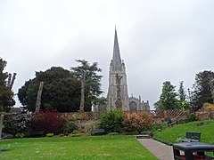
Saffron Walden is a market town in the Uttlesford district of Essex, England, 12 miles (19 km) north of Bishop's Stortford, 15 miles (24 km) south of Cambridge and 43 miles (69 km) north of London. It retains a rural appearance and some buildings of the medieval period. The population was 15,504 at the 2011 census and 16,613 in the 2021 census.

<span class="mw-page-title-main">Bishop's Stortford</span> Commuter town in Hertfordshire, England

Bishop's Stortford is a historic market town in the London commuter belt. Located in Hertfordshire near the border with Essex, just west of the M11 motorway and Stansted Airport, it is 22 miles north-east of Central London and 34 minutes away by rail from Liverpool Street station. The town had an estimated population of 41,088 in 2020. The district of East Hertfordshire, where the town centre is located, has been ranked as the best place to live in the UK by the Halifax Quality of Life annual survey in 2020. The town is commonly known as Stortford by locals.

<span class="mw-page-title-main">Great Dunmow</span> Human settlement in England

Great Dunmow is a historic market town and civil parish in the Uttlesford district of Essex, England. It lies to the north of the A120 road, approximately midway between Bishop's Stortford and Braintree, 5 mi (8 km) east of London Stansted Airport.

<span class="mw-page-title-main">Takeley</span> Human settlement in England

Takeley (Also known as Kervin town) is a village and civil parish in the Uttlesford district of Essex, England.

Saffron Walden Rural District was a rural district in the county of Essex, England. It was created in 1894 and later enlarged by the addition of the parishes of Berden, Birchanger, Elsenham, Farnham, Henham-on-the-Hill, Manuden, Stansted Mountfitchet and Ugley from the disbanded Stansted Rural District. It was named after and administered from Saffron Walden.

<span class="mw-page-title-main">Stansted Mountfitchet</span> Village in Essex, England

Stansted Mountfitchet is an English village and civil parish in Uttlesford district, Essex, near the Hertfordshire border, 35 miles (56 km) north of London. According to the 2001 census it had a population of 5,533, increasing to 6,011 at the 2011 census. By the 2021 census it had increased to 8621. The village is served by Stansted Mountfitchet railway station.

<span class="mw-page-title-main">Saffron Walden (UK Parliament constituency)</span> Parliamentary constituency in the United Kingdom since 1885

Saffron Walden is a constituency in Essex, represented in the House of Commons of the UK Parliament since 2017 by Kemi Badenoch, a Conservative.

<span class="mw-page-title-main">Birchanger</span> Human settlement in England

Birchanger is a village in Essex, England, 3 km (1.9 mi) northeast of Bishop's Stortford and 25 km (16 mi) northwest of the county town, Chelmsford. The village is in the district of Uttlesford and the parliamentary constituency of Saffron Walden. There is a Parish Council.

Stansted was a rural district in Essex, England from 1894 to 1934.

<span class="mw-page-title-main">Molehill Green</span> Human settlement in England

Molehill Green is a hamlet in Takeley parish in Essex, England, close to the perimeter of London Stansted Airport, The hamlet consists of approximately forty houses and lies about 2.2 miles (3.5 km) north of Takeley village.

<span class="mw-page-title-main">A120 road</span> Road in the east of England

The A120 is an A-road in England, which runs between Puckeridge in Hertfordshire and Harwich in Essex.

<span class="mw-page-title-main">Wendens Ambo</span> Human settlement in England

Wendens Ambo is a village in the Uttlesford district of Essex, England. The population at the 2011 census was measured at 473. Its name originates from the merging of two originally separate villages called Wenden Magna and Wenden Parva, ambo being the Latin for "both".

Bentfield Bury is a small village in Essex, England. It is one of over 100 villages in the district of Uttlesford and is within Stansted Mountfitchet parish. Nearby towns include Saffron Walden and Bishop's Stortford.

<span class="mw-page-title-main">The Hundred Parishes</span> Area of eastern England

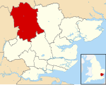
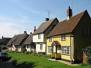
The Hundred Parishes is an area of the East of England with no formal recognition or status, albeit that the concept has the blessing of county and district authorities. It encompasses around 450 square miles of northwest Essex, northeast Hertfordshire and southern Cambridgeshire. The area comprises just over 100 administrative parishes, hence its name. It contains over 6,000 listed buildings and many conservation areas, village greens, ancient hedgerows, protected features and a historical pattern of small rural settlements in close proximity to one another.

Residents for Uttlesford (R4U) is a localist political party in the United Kingdom. The party was launched in 2014, and formed from a number of residents groups in the area. The party is based in the Uttlesford administrative district in Essex and promotes a localist agenda that seeks to give residents a greater say in the future of their district. Residents for Uttlesford has elected representation at multiple levels of local government: Uttlesford District Council, Essex County Council and various town and parish councils, including the councils for both towns in Uttlesford, Saffron Walden and Great Dunmow.

North West Essex is a proposed constituency of the House of Commons in the UK Parliament. Further to the completion of the 2023 Periodic Review of Westminster constituencies, it will first be contested at the next general election.

References

  1. 1 2 UK Census (2021). "2021 Census Area Profile – Uttlesford Local Authority (E07000077)". Nomis. Office for National Statistics . Retrieved 5 January 2024.
  2. "The English Non-metropolitan Districts (Definition) Order 1972", legislation.gov.uk , The National Archives, SI 1972/2039, retrieved 31 May 2023
  3. "The English Non-metropolitan Districts (Names) Order 1973", legislation.gov.uk , The National Archives, SI 1973/551, retrieved 31 May 2023
  4. Samuel Lewis (1848). "A Topographical Dictionary of England". Institute of Historical Research. Retrieved 4 December 2012.
  5. Open Domesday: Hundred of Uttlesford. Accessed 6 January 2022.
  6. "Meaning of Parish Names Villages in NW Essex".
  7. "History of the Society – Saffron Walden Symphony Orchestra".
  8. Dunderdale, Louise (14 September 2021). "Peter Holt is appointed as the new district council chief executive". Saffron Walden Reporter. Retrieved 12 June 2023.
  9. "Local Government Act 1972", legislation.gov.uk , The National Archives, 1972 c. 70, retrieved 31 May 2023
  10. "Compositions calculator". The Elections Centre. Retrieved 1 June 2023.
  11. "Council minutes". Uttlesford District Council. Retrieved 31 May 2022.
  12. "Local elections 2023: live council results for England". The Guardian.
  13. "Contact us". Uttlesford District Council. Retrieved 12 June 2023.
  14. "Bright new future for old town hospital". Saffron Walden Weekly News. 3 May 1990. p. 29. Retrieved 12 June 2023.
  15. "The Uttlesford (Electoral Changes) Order 2014", legislation.gov.uk , The National Archives, SI 2014/1334, retrieved 12 June 2023
  16. "Town and parish councils". Uttlesford District Council. Retrieved 12 June 2023.
  17. "London airports given green light to expand". The Times. 9 October 2008. Retrieved 11 August 2015.
  18. "Contact Us". Titan Airways. Retrieved 11 August 2015.
  19. "Contact Us." Buzz. Retrieved on 2 September 2009.
  20. "Home-page."[ sic ] AirUK. Retrieved on 28 February 2010.
  21. "World Airline Directory." Flight International . 18–24 March 1998. 82.
  22. An Introduction to AB Airlines AB Airlines article 30 January 1998. Retrieved on 7 February 2011. "AB Airlines - Internet Enquiry Office Enterprise House, Stansted Airport Essex. CM24 1QW"
  23. "World Airline Directory." Flight International . 27 March-2 April 2001. 77. ibid. however postcode: CM241SB
  24. "World Airline Directory." Flight International later "Lloyd International Airways" were established at Lloyd House, Stansted from 10 April 1969. 580. "Head Office: Lloyd House, First Avenue, Stansted Airport, Essex."
  25. "Full Freeview on the Sudbury (Suffolk, England) transmitter". May 2004.
  26. "Sandy Heath (Central Bedfordshire, England) Full Freeview transmitter". May 2004.
  27. "Crystal Palace (Greater London, England) Full Freeview transmitter". May 2004.
  28. "London & the South East Rail Services" (PDF). National Rail . Archived from the original (PDF) on 17 April 2019.
  29. "Highways Information Map | Essex County Council". essexhighways.org. Retrieved 17 April 2019.
  30. "The UK's Innovation Corridor | About". The UK's Innovation Corridor. Archived from the original on 17 April 2019.
  31. "Uttlesford Community Travel | Uttlesford Community Travel". uttlesfordcommunitytravel.org. Retrieved 13 March 2023.
  32. "Facts and figures". London Stansted Airport. Retrieved 17 April 2019.
  33. "Essex Bus | Bus Routes and Timetables". Essex Bus. Archived from the original on 17 April 2019.
  34. "First Essex | Chelmsford Network Map" (PDF). First Bus.
  35. "Arriva | Our services in Bishop's Stortford & Stansted" (PDF). Arriva Bus. Archived from the original (PDF) on 17 April 2019.
  36. "Cambridge out of town links" (PDF). Stagecoach Bus. Archived from the original (PDF) on 17 April 2019.
  37. "Coach and Bus Services at London Stansted". London Stansted Airport. Retrieved 17 April 2019.
  38. "In Depth | UK House Prices | Uttlesford". BBC News. 21 October 2013. Retrieved 11 August 2015.

Commons-logo.svg Media related to Uttlesford at Wikimedia Commons

52°01′08″N0°14′12″E / 52.0190°N 0.2367°E / 52.0190; 0.2367