Wildcat Mountain State Park

Last updated

Wildcat Mountain State Park
TypicalDriftless.jpg
A view of the Driftless Area from Wildcat Mountain State Park
USA Wisconsin relief location map.svg
Red pog.svg
Location of Wildcat Mountain State Park in Wisconsin
Usa edcp relief location map.png
Red pog.svg
Wildcat Mountain State Park (the United States)
Location Vernon, Wisconsin, United States
Coordinates 43°41′53″N90°33′45″W / 43.69806°N 90.56250°W / 43.69806; -90.56250
Area3,643 acres (14.74 km2)
Established1948
Governing bodyWisconsin Department of Natural Resources
Website Wildcat Mountain State Park

Wildcat Mountain State Park is a state park of Wisconsin, United States, on the Kickapoo River in the Driftless Area. Sandstone bluffs topped with limestone, two of which are Wildcat Mountain and Mount Pisgah, provide views over the narrow valley of the river and its tributaries. The Kickapoo Valley Reserve is immediately adjacent and forms a continuous protected area. Wildcat Mountain State Park is open for year-round recreation including hiking, canoeing, fishing, and cross-country skiing. The 3,643-acre (1,474 ha) park is located in Vernon County near the town of Ontario, Wisconsin.

Contents

History

Wildcat Mountain State Park is in the Kickapoo Valley. Archaeologists have found evidence of human occupation in the area dating back to 2000 BCE. [2] Indian rock shelters and mounds have been found in and around the park. Most archaeologists believe that the shelters and mounds are remnants of temporary hunting camps. No evidence of agricultural practices have been found in the vicinity. Historians believe that the Natives used the Kickapoo Valley as a hunting area and held more permanent settlements near Tomah to the north and near the confluence of the Kickapoo and Wisconsin Rivers to the south. [2]

The Kickapoo River was known as the "river of canoes" to the Indians who lived in the area. It was canoes that brought the first European explorers to the area. French voyageurs from New France explored the area and called the area Bateaux. The first English-speakers to see it were British fur traders who made use of the area after the end of the French and Indian War. When English-speaking settlers arrived in the area they pronounced it as Bad Axe. In fact, Vernon County was originally known as Bad Axe County and the name was not changed until 1862 to Vernon, which means greenness. [2]

When the first American pioneers arrived in the Kickapoo Valley it was home to the Meskwaki and Sac Indians and later the Ho-Chunk. The Native Americans were forced from their land in 1837 when the government of the United States compelled the Ho-Chunk to move to points west of the Mississippi River. [2] The land was covered with vast expanses of old-growth forests that were to soon fall under the axe of the lumberman. The first several waves of Americans to settle permanently in the area were "Yankee" settlers, that is to say they were from the New England states and were descended from the English Puritans who settled that region in the colonial era. The first "Yankee" settlers were overwhelmingly Congregationalist, and a few Congregationalist churches remain in the area to this day. When the New Englanders came to the area around Wildcat Mountain they were coming primarily as lumbermen and also as farmers. The second wave were Cornish miners who had come to the region as tin miners.

The need for lumber as the United States was growing was tremendous. Trees in New England were among the first to fall as they were nearest the early settlements of Boston and New York City. The forests of Pennsylvania fed the need for lumber in Philadelphia, Baltimore, Pittsburgh and the coal mines of the region. The lumber industry reached Wisconsin by 1844. [2]

John Ostrander and William Saubert bought up many acres of land on what is now Wildcat Mountain State Park. Their lumber company purchased the land for $1.25 an acre from the government. Ostrander and Saubert clear-cut the forests and then sold the cleared land to new settlers for $2.50 an acre. [2] A small community of lumberjacks and their families remained in the area as long as there were trees to be bought. Their settlement included a gristmill, post office and school. The community was abandoned by 1900. [2]

Many people remained in the area and established small family farms. They used the natural resources of the Driftless Area in the Kickapoo Valley to provide them with many of their needs. They built their homes near streams that provided a steady supply of fresh water and fish for eating. [2]

The lumber industry had a negative effect on the environment. Over harvesting of timber affected the water table in the Kickapoo Valley. The lack of trees and their extensive root systems underground caused an increase in runoff. Instead of soaking into the ground and trees the water was flushed out of the valley and down the river. The water level of the streams dropped and many natural springs dried up. Over use of the natural resources forced some of the early settlers to move on and the lumber towns were abandoned. [2]

A thriving ginseng business was once prominent in the economy of Vernon County. The root of the plant was widely used by Chinese people to cure and ward off various types of disease. Residents of the area harvested the naturally growing ginseng and sold it at market in Woodstock, Illinois. For a time Vernon County was the greatest producer of ginseng in the United States. [2]

The protection of what became Wildcat Mountain State Park started off in 1938 when a local man, Amos Saunders, donated 20 acres (8.1 ha) of land for the establishment of a park. The park grew to 60 acres (24 ha) in 1947 when it was acquired by the state of Wisconsin for a state park. The park, formally established in 1948, has since grown to a size of 3,643 acres (1,474 ha). [2]

Geology

A sandstone outcrop on the flanks of Mount Pisgah Mount Pisgah sandstone.JPG
A sandstone outcrop on the flanks of Mount Pisgah

Wildcat Mountain State Park lies within the Driftless Area. This is an area of Wisconsin, Minnesota, Iowa and Illinois that was not covered by glaciers in the Last Ice Age. [3] The term "driftless" indicates a lack of glacial drift, the material left behind by retreating continental glaciers. The hills of the Driftless Area are made of Precambrian sandstone that is topped with limestone. Overall the region is characterized by an eroded plateau with bedrock overlain by varying thicknesses of loess. Most characteristically, the river valleys are deeply dissected. The bluffs lining this reach of the Mississippi River drainage basin currently climb to not quite 600 feet (180 m). [4]

Ecology

Wildcat Mountain State Park has a woodland ecosystem. The Kickapoo River Valley and the park provide a habitat for many animals typically found in the woods of the Upper Midwest. Common birds include tundra swans, Canada geese, great blue herons, sandpipers, wild turkeys, red-tailed hawks, bald eagles and turkey vultures. Reptiles are also found in the park including, five-lined skinks, red-bellied snakes and eastern hog-nosed snakes. White-tailed deer, red squirrels, and beaver are among the mammals found in the park. [5]

Mount Pisgah in Wildcat Mountain State Park has been preserved. It is covered with old-growth white pine and hemlock trees. The hill was never logged off by lumbermen and never grazed by the livestock of farmers in the area. The park is also home to ferns including maidenhair, interrupted and the unusual walking fern. [5]

Recreation

Wildcat Mountain State Park is open for year-round recreation. The Kickapoo River is known for its many miles of slow moving waters that flow through wild areas. The river attracts canoeing enthusiasts to the park. Canoeists can observe rare plants growing on the banks of the river and observe wildlife that live on the riverbanks including muskrats, belted kingfishers, green herons and great blue herons. [5] Biologic surveys on the river have documented up to 46 species of fish. The Kickapoo has been designated a Class II trout stream. Brown trout spawn in tributaries of the river within the park. [6]

Wildcat Mountain State Park has more than 20 miles (32 km) of trails that are open to hiking, snow shoeing, horseback riding and cross-country skiing. Additionally the park offers interpretative programs, an amphitheater, picnic facilities, stations for bird and wildlife viewing, and an outlook viewing the lower valley and Kickapoo River. [6]

Related Research Articles

<span class="mw-page-title-main">Vernon County, Wisconsin</span> County in Wisconsin, United States

Vernon County is a county in the U.S. state of Wisconsin. As of the 2020 census, the population was 30,714. Its county seat is Viroqua.

<span class="mw-page-title-main">Cedarburg (town), Wisconsin</span> Town in Ozaukee County, Wisconsin

Cedarburg is a town in Ozaukee County, Wisconsin, United States, and is in the Milwaukee metropolitan area. The town was created in 1849 and at the time of the 2020 census had a population of 6,162.

<span class="mw-page-title-main">Driftless Area</span> Geological region in the Midwestern US

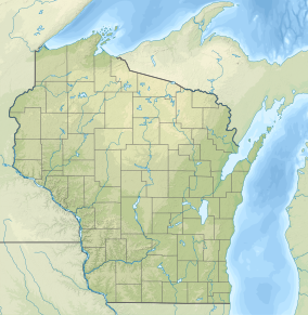
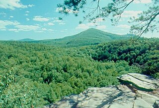
The Driftless Area, also known as Bluff Country and the Paleozoic Plateau, is a topographical and cultural region in the Midwestern United States that comprises southwestern Wisconsin, southeastern Minnesota, northeastern Iowa, and the extreme northwestern corner of Illinois. The Driftless Area is a USDA Level III Ecoregion: Ecoregion 52. The Driftless Area takes up a large portion of the Upper Midwest forest–savanna transition. The Blufflands refers to the eastern section of the Driftless area in Minnesota, due to the steep bluffs and cliffs around the river valleys. The western half is known as the Rochester Plateau, which is flatter than the Blufflands. The Coulee Region refers to the southwestern part of the Driftless Area in Wisconsin. It is named for its numerous ravines.

<span class="mw-page-title-main">Kickapoo River</span> River in Wisconsin, United States

The Kickapoo River is a 126-mile-long (203 km) tributary of the Wisconsin River in the state of Wisconsin, United States. It is named for the Kickapoo Indians who occupied Wisconsin before the influx of white settlers in the early 19th century.

<span class="mw-page-title-main">Western Upland</span> Geographical region of Wisconsin

The Western Upland is a geographical region covering much of the western half of the U.S. state of Wisconsin. It stretches from southern Polk County, Wisconsin in the north to the state border with Illinois in the south, and from Rock County in the east to the Mississippi River in the west.

<span class="mw-page-title-main">Chippewa River (Wisconsin)</span> River in Wisconsin, United States

The Chippewa River in Wisconsin flows approximately 183 miles (294 km) through west-central and northwestern Wisconsin. It was once navigable for approximately 50 miles (80 km) of its length, from the Mississippi River, by Durand, northeast to Eau Claire. Its catchment defines a portion of the northern boundary of the Driftless Area. The river is easily accessible for bikers and pleasure seekers via the Chippewa River State Trail, which follows the river from Eau Claire to Durand.

<span class="mw-page-title-main">William O'Brien State Park</span> State park in Minnesota

William O'Brien State Park is a 1,520-acre (6.2 km2) state park of Minnesota, USA, along the St. Croix River. Its hiking trails traverse rolling glacial moraine, riparian zones, restored oak savanna, wooded areas and bogs. It is a popular place for birdwatching, picnics, camping, cross-country skiing, canoeing, fishing, and other typical outdoor recreational activities.

<span class="mw-page-title-main">Saint Croix State Park</span> United States historic place

St. Croix State Park is a state park in Pine County, Minnesota, USA. The park follows the shore of the St. Croix River for 21 miles (34 km) and contains the last 7 miles (11 km) of the Kettle River. At 33,895 acres (13,717 ha) it is the largest Minnesota state park. It was developed as a Recreational Demonstration Area in the 1930s, and is one of the finest surviving properties of this type in the nation. 164 structures built by the Civilian Conservation Corps and the Works Progress Administration survive, the largest collection of New Deal projects in Minnesota. As a historic district they were listed on the National Register of Historic Places and proclaimed a National Historic Landmark in 1997.

<span class="mw-page-title-main">Perrot State Park</span> State Park in Trempealeau County, Wisconsin

Perrot State Park is a state park in Wisconsin's Driftless Area at the confluence of the Trempealeau and Mississippi rivers. The 1,270-acre (514 ha) park features views of steep limestone bluffs and the river valleys. It has observation platforms for watching wildlife, including the variety of birds which inhabit or migrate through the park. Hiking trails and camping are available. Mountain bike trails penetrate deep inside the park.

<span class="mw-page-title-main">Wisconsin Highway 131</span> State highway in Wisconsin, United States

State Trunk Highway 131 is a 78.9-mile (127.0 km) state highway in the U.S. state of Wisconsin. The highway is located in Wisconsin's Driftless Area, passing through Crawford, Vernon, Richland, and Monroe counties. It runs from WIS 60 near Wauzeka north to US Highway 12 and WIS 16 in Tomah. WIS 131 is maintained by the Wisconsin Department of Transportation (WisDOT).

<span class="mw-page-title-main">Trough Creek State Park</span> State park in Huntingdon County, Pennsylvania

Trough Creek State Park is a 554 acres (224 ha) Pennsylvania state park in Cass, Penn and Todd Townships, Huntingdon County, Pennsylvania in the United States. The majority of the park is in Todd Township along Pennsylvania Route 994, east of the unincorporated village of Entriken. Huntingdon is the nearest borough. The park borders Rothrock State Forest and Raystown Lake National Recreation Area. There is a growing population of bald eagles at the lake. Fourteen eagles were spotted in January 2007. This is up from two that were spotted in 1990, the first year that an eagle survey was taken. These three sections of state and federal owned property combine together to provide hunting, hiking and fishing opportunities for the outdoorsman.

<span class="mw-page-title-main">Wyalusing State Park</span> State park in Grant County, Wisconsin

Wyalusing State Park is a 2,628-acre (1,064 ha) Wisconsin state park at the confluence of the Mississippi and Wisconsin rivers in the village Bagley, just south of Prairie du Chien.

<span class="mw-page-title-main">Geography of Minnesota</span> Overview of the geography of Minnesota

The U.S. State of Minnesota is the northernmost state outside Alaska; its isolated Northwest Angle in Lake of the Woods is the only part of the 48 contiguous states lying north of the 49th parallel north. Minnesota is in the U.S. region known as the Upper Midwest in interior North America. The state shares a Lake Superior water border with Michigan and Wisconsin on the northeast; the remainder of the eastern border is with Wisconsin. Iowa is to the south, South Dakota and North Dakota are to the west, and the Canadian provinces of Manitoba and Ontario are to the north. With 87,014 square miles (225,370 km2), or approximately 2.26% of the United States, Minnesota is the 12th largest state.

<span class="mw-page-title-main">Black River State Forest</span> State Forest in Jackson County, WIsconsin

Black River State Forest is a state forest located in the western half of Jackson County, Wisconsin near Black River Falls, Wisconsin, U.S.A.. It is administered by the Wisconsin Department of Natural Resources. The park has campsites, trails, and allows for hunting, ATV, and canoeing. It is at the edge of the Driftless Area of Wisconsin, and is more rugged than what is found in the eastern half of the county.

<span class="mw-page-title-main">Mount Vernon, Wisconsin</span> Unincorporated community in Wisconsin, United States

Mount Vernon is an unincorporated community in the town of Springdale, Dane County, Wisconsin, United States.

Kickapoo State Recreation Area is an Illinois state park on 2,842 acres (1,150 ha) in Vermilion County, Illinois, United States. Located between Oakwood, Illinois and Danville, Illinois, this park is easily accessible through route I-74. It is 28 miles (45 km) away from the University of Illinois at Urbana-Champaign and 95 miles (153 km) from Indianapolis. According to the Illinois Department of Natural Resources, the name Kickapoo originated from the Kickapoo village that once existed near the junction of the Salt Fork and Middle Fork branches of the Vermilion River. After Europeans settled in the area and displaced the Native Americans, the Europeans began to dig wells to harvest salt from salt springs, called salines. In the early 20th century the land was then strip-mined for coal. Kickapoo State Park was the first park in the United States to be located on strip-mined land. The state of Illinois purchased the Kickapoo State Park Area in 1939 with donation money from Danville residents and the land has since recovered from the extraction of these resources.

<span class="mw-page-title-main">Pennsylvania Lumber Museum</span>

The Pennsylvania Lumber Museum is near Galeton, Potter County, Pennsylvania in the United States. It documents the history and technology of the lumber industry that was a vital part of the economic development and ecological destruction of Pennsylvania.

<span class="mw-page-title-main">Patapsco Valley State Park</span> State park in Maryland, United States

Patapsco Valley State Park is a Maryland state park extending along 32 miles (51 km) of the Patapsco River south and west of the city of Baltimore, Maryland. The park encompasses multiple developed areas on over 14,000 acres (5,700 ha) acres of land, making it Maryland's largest state park. In 2006, it was officially celebrated as Maryland's first state park, its first formation being in 1906. Patapsco Valley State Park is managed by the Maryland Department of Natural Resources.

<span class="mw-page-title-main">Weister Creek</span> River in Wisconsin, United States

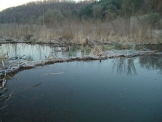
Weister Creek is a stream, some 25 miles (40 km) long, in Vernon County in southwestern Wisconsin in the United States and is a tributary of the Kickapoo River. It lies in the Driftless Area which is characterized by hills and valleys apparently missed by the last glacial advance during the Pleistocene. Much of the lower half of Weister Creek is surrounded by wetlands and lies in the Kickapoo Valley Reserve.

Menominee River State Recreation Area is a state-managed protected area located in Breitung and Norway townships in Dickinson County and Faithorn Township in Menominee County, Michigan, southeast of Iron Mountain. It is 2,354 acres (953 ha) in area and is currently undeveloped. The park comprises a 145.35-acre (58.82 ha) tract along 1.5 miles (2.4 km) of the Menominee River south of the City of Norway and the 2,208.83-acre (893.88 ha) Quiver Falls Tract along eight miles (13 km) of the river farther downstream. In 2016, an additional 525-acre (212 ha) of Escanaba State Forest land was transferred from the Forestry Division to the DNR's Parks and Recreation Division and became the Pemene Falls Unit of the park, matching a similarly named unit on the Wisconsin side of the river.

References

  1. Protected Planet. "Wildcat Mountain State Park". United Nations Environment World Conservation Monitoring Centre. Retrieved December 26, 2018.
  2. 1 2 3 4 5 6 7 8 9 10 11 "History". Wildcat Mountain State Park. Wisconsin DNR. Retrieved January 21, 2013.
  3. "Geology". Wildcat Mountain State Park. Wisconsin DNR. Retrieved January 21, 2013.
  4. "Regional Landscape Ecosystems of Michigan, Minnesota, and Wisconsin, Section IV, Driftless Area". Northern Prairie Wildlife Research Center. Retrieved July 3, 2010.
  5. 1 2 3 "Nature". Wildcat Mountain State Park. Wisconsin DNR. Retrieved January 21, 2013.
  6. 1 2 "Activities and recreation". Wildcat Mountain State Park. Wisconsin DNR. Retrieved January 21, 2013.