
Sullivan County is a county in the U.S. state of New York. As of the 2010 census, the population was 77,547. The county seat is Monticello. The county's name honors Major General John Sullivan, who was a hero in the American Revolutionary War.
Mamakating is a town in the southeast part of Sullivan County, New York, United States. The population was 12,085 at the 2010 census.
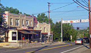
Wurtsboro is a village located on U.S. Route 209 in the town of Mamakating in Sullivan County, New York, United States, near its junction with New York State Route 17. The population was 1,246 at the 2010 census. Since 1927 the area has been served by Wurtsboro-Sullivan County Airport. From spring through the fall, the area provides a scenic backdrop and destination for motorcyclists in conjunction with events sponsored by the Wurtsboro chapter of the Harley Owners Group.

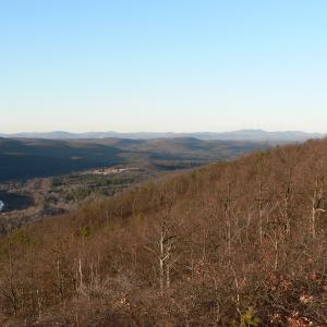
The Catskill Mountains, also known as the Catskills, are a physiographic province of the larger Appalachian Mountains, located in southeastern New York. As a cultural and geographic region, the Catskills are generally defined as those areas close to or within the borders of the Catskill Park, a 700,000-acre (2,800 km2) forest preserve forever protected from many forms of development under New York state law.

New York State Route 17M (NY 17M) is an east–west state highway in Orange County, New York, in the United States. It extends for 26.63 miles (42.86 km) from west of the city of Middletown to what is currently the north–south section of NY 17 just southeast of the village of Harriman. It is a busy main street in Middletown and the village of Monroe; in the former, it divides into a parkway for several blocks and forms the city's major commercial strip, located between the downtown district and an interchange with Interstate 84 (I-84). The rest of the road is a two-lane rural route. Between New Hampton and Goshen, the highway overlaps with U.S. Route 6 (US 6). The easternmost section of that overlap near Goshen is routed on the Quickway, making a three-route concurrency with NY 17.

Westbrookville is a hamlet in the town of Deerpark, Orange County, New York, United States, along US 209. Westbrookville was named for Dirck Van Keuren Westbrook, an early settler. Fort Westbrook, dating back to the American Revolution, is extant. The 1900-1940 US Census lists it as part of Mamakating in Sullivan County, New York. Situated between Port Jervis and Wurtsboro, it is close to the borders of Pennsylvania and New Jersey. It is located within the Port Jervis City School district. It contains many small businesses and Westbrookville Cemetery.
WZAD(The Wolf) is country music radio station licensed to Wurtsboro, New York that serves the Catskill Mountains region, Orange County, New York, and Pike County, Pennsylvania. The station is owned by Townsquare Media and broadcasts on 97.3 MHz with 620 watts ERP from a tower between Wurtsboro and Monticello. Its studios are in Poughkeepsie, New York.

The Middletown–Town of Walkill station, often just referred to as the Middletown station, is a stop on the Metro-North Railroad's Port Jervis Line serving Middletown and Town of Wallkill in Orange County, New York. Service is to Hoboken, 71.9 miles (116 km); travel time is an hour and 40 minutes. Like all Port Jervis Line stations, this station serves commuters from a wide area. Many commuters use nearby NY 17 to reach the station from communities in Sullivan County such as Wurtsboro and Monticello. Two trains end at this station on weekdays, with one Hoboken-bound train departing Middletown as well. New Jersey Transit departure boards and announcements may list the station as Middletown NY to distinguish it from the identically named station in Monmouth County, New Jersey.

Black Mountain is a large hill which overlooks the city of Belfast, Northern Ireland.

Alander Mountain, 2,239 feet (682 m), is a prominent peak of the south Taconic Mountains; it is located in southwest Massachusetts and adjacent New York. Part of the summit is grassy and open and part is covered with scrub oak and shrubs; the sides of the mountain are wooded with northern hardwood tree species. Views from the top include the southern Taconic Mountains, the Hudson River Valley including the Catskills. Several trails traverse Alander Mountain, most notably the 15.7 mi (25.3 km) South Taconic Trail, which passes just beneath the summit.
Berry Hill, 2,200 feet (670 m), is a prominent mountain in the Taconic Mountains of western Massachusetts. The mountain is located in Pittsfield State Forest and is traversed by a short spur trail from a park automobile road. The Taconic Crest hiking trail and the multi-use Taconic Skyline Trail are located nearby. The mountain is known for its wild azalea fields. Its slopes are wooded with northern hardwood forest species. A park loop automobile road nearly encircles the summit, and a campground, maintained for summer use, is located just to the south of the summit. Berry Pond, 2,150 feet (660 m), presumed the highest natural pond in the state of Massachusetts, is located on the ridge between Berry Hill and Berry Mountain to the south.

Haven is a hamlet south of Wurtsboro, New York, on route 209 and Haven Road which crosses the Basha Kill to the South Rd. The area is known by the old Moose Lodge which now appears to be closed. The Brownsville cemetery is at the end of Tow Path Road, a cemetery from the 1830s situated in the woods above the Basha Kill. The hamlet also has Giovanni's Inn, which is an Italian restaurant.
Mountain Meadow Preserve is a 176-acre (71 ha) open space preserve located in the Berkshires and Green Mountains of northwest Massachusetts and adjacent Vermont in the towns of Williamstown and Pownal. The property, acquired in 1998 by the land conservation non-profit organization The Trustees of Reservations, includes highland meadows, wetlands, forested hills, and 4 miles (6.4 km) of trails.
Wurtsboro–Sullivan County Airport is a privately owned, public use airport located two nautical miles (4 km) northeast of the central business district of Wurtsboro, in Sullivan County, New York, United States. It is privately owned by Shalom Lamm. It is commonly called Wurtsboro Airport.

The New River Mountains are a small 14-mi (23 km) long, mountain range in central Arizona, and on the north border of the Phoenix valley; the range is located on the southwest perimeter of the Arizona transition zone. The range is a sub-part of landforms extending south from the Black Hills of Yavapai County. Rivers and canyons border east and west; the south of the range is located in Maricopa County, the location of much of the Phoenix metropolitan area.
Wurtsboro Hills is a hamlet in the town of Mamakating, New York in Sullivan County, New York, United States. The hamlet is located along old NY 17 west of the Village of Wurtsboro. The telephone exchange is primarily 888 and along with 647 in Area Code 845. The hamlet consists for over 100 bungalows primarily from the 1920s to the 1960s.
Gross Hill is a mountain in the Central New York Region of New York. It is located northwest of Garrattsville, New York. Crystal Lake is located south and Wooley Hill is located northeast of Gross Hill.

Fox Hill is a mountain located in Adirondack Mountains of New York located in the Town of Indian Lake east of Indian Lake.
Wilders Hill is a mountain located in Central New York Region of New York east of Richfield Springs, New York. Waiontha Mountain is located southeast of Wilders Hill.
Red Hill is a mountain located in the Catskill Mountains of New York east-south of Frost Valley. Woodhull Mountain is located northeast of Red Hill.

